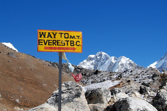
Mt. Everest Base Camp trek - walk among some of the highest mountains in the world
If there is one mountain that has captivated people it must be Mt. Everest (8.848m) the highest mountain in the world. Legends as George Mallory, Sir Edmund Hillary and Tenzing Norgay inspired many mountaineers. To reach the top of Everest became a dream to many.
Several trails lead to the roof of the world. In the early 1900s, Nepal was closed to people from the West. When George Mallory tried to reach the top of Everest in 1924, he had to do it from the Tibetan side. In 1948 Nepal opened up, permitting teams to visit the Everest region. When Hillary and Norgay conquered Everest in 1953, it was from the Nepalese side. Thousands have followed them in an attempt to reach the top. Many sacrifices have been made. Many have died in the attempt. But the interest in the Himalayas grew. In the 1960s the region started to attract others than mountaineers. Since then, walking to Everest Base Camp have come to be regarded as the ultimate trek. Still it is one of the world's best-known treks.
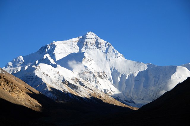
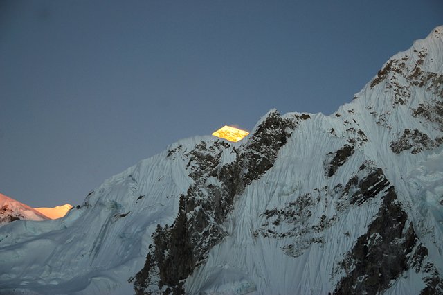
Everest seen from Rongbuk in Tibet
When travelled in the Himalaya region, I went to both Tibet and Nepal. Driving from Lhasa to Katmandu, crossing the Himalayas and visited Everest Base Camp (5.200m) on the Tibetan side. It is possible to drive up to Rongbuk guesthouse. From here it is only a few kilometers to walk to base camp. You see Everest from the guesthouse (photo above) To visit Tibet first, also helped me to acclimatize. The first days in Lhasa I felt the altitude, but was fine in Nepal.
In Nepal you cannot drive to base camp. The only way is walking. I joined a tour, starting and ending in Lukla, following more or less the same route both up and down. It took 8 days up and 4 days down. Because of the altitude one has to ascend slowly. Booking through a tour agent ensured everything was taken care of: transportation, accommodation, meals, permits, a list of what to pack and how to prepare. You can prepare for the walk, but not for altitude unless you do as I did by visiting Tibet first. Now, a brief describtion day by day.
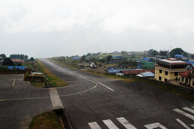
Lukla airstrip
Day 1: Katmandu – Lukla (2.800m) – Phakding (2.300m)
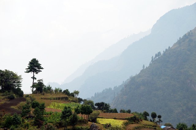
After a few days in Katmandu, I left the city and the noise of it behind me, to seek solace in the Himalayas. Started with a short flight to Lukla. A small town on the mountainside. It has one of the most amazing airfields I have seen! A runway which is angled upwards! Supposedly to help the planes slow down since the runway is short. The first day was a pleasant walk in a green landscape with vegetable fields.
On the way to Phakding
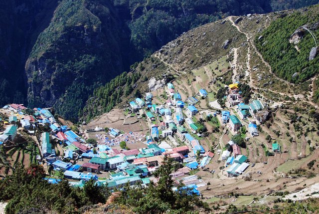
Namche Bazar
Day 2 & 3: Phakding – Namche Bazar (3.440m)
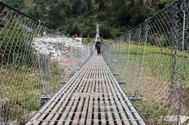
On our second day we entered Sagarmartha National Park, which was established in 1976 to protect this area of 1.148 km2 and UNESCO world heritage site. The permit was obtained here. Crossing the last and highest suspension bridge was a real dizzying experience! I stared right into the back of the guy in front of me! Then a long, tough climb up to Namche started. 700 m. uphill! I was completely exhausted when we arrived our tea-house. Most people stay two nights here, to acclimatize and help the body adapt to altitude. Namche Bazar is the main town and the largest of the Sherpa settlements in the Khumbu region. It has a large number of hotels, tourist shops, bakery, internet cafes etc. It has everything a trekker might need, so no worries if you have forgotten something! Great to have an extra day in the “city”!
Phortse

Lhotse & Everest to the left. Ama Dablam to the right
Arriving Dingboche
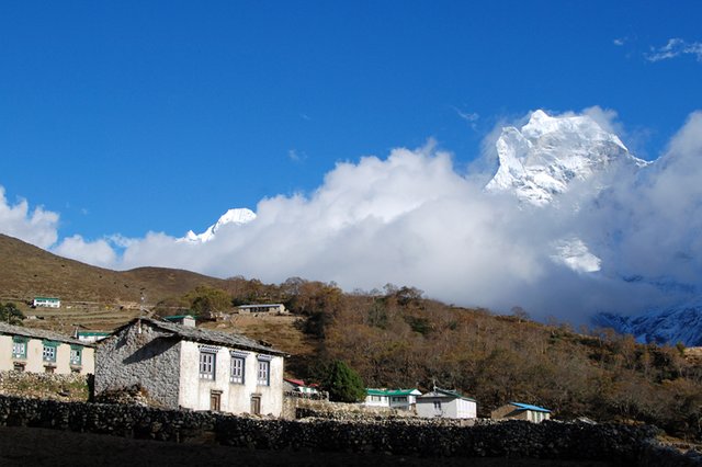
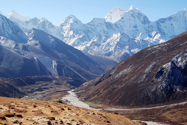
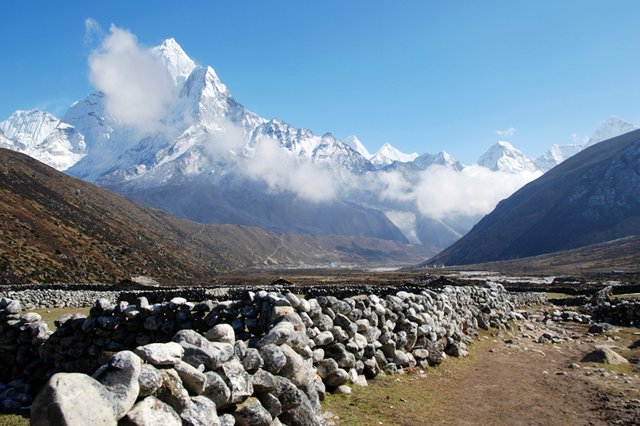
Day 4, 5 & 6: Namche Bazar – Phortse (3.800m) – Dingboche (4.410m)
The trail to Phortse follows a yak trail on the edge of the mountain side. An easy trek. We also got the first glimpse of Everest. Next day we continued to Dingboche. That was a long day, but we got a closer view of some of the worlds highest mountains. Dingboche is located in a valley between Lhotse (8.501m) on one side and Ama Dablam (6.856m) on the other side. Amazing sight! Again an acclimatization day. At this height some started getting light headaches.
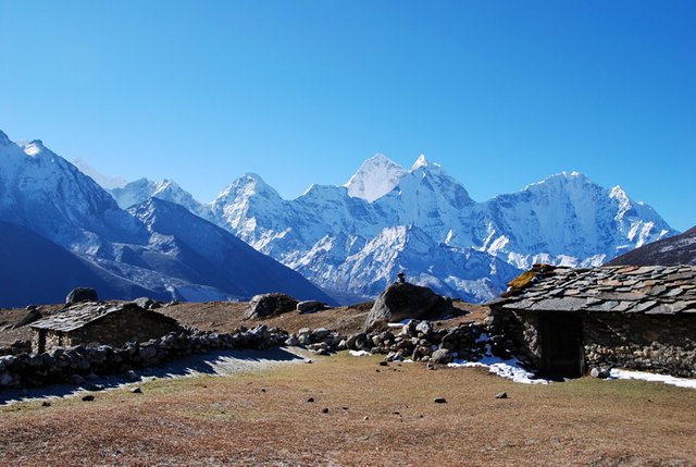
Shelters for yak herdsmen
Pherice in the Khumbu valley
In memory of those who died on Everest
The mountains which marks the border to Tibet
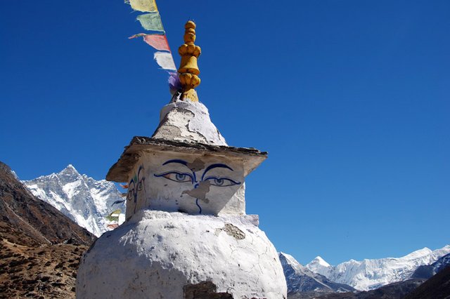
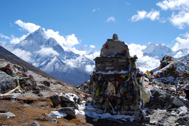
Day 7: Dingboche – Lobuche (4.940m)
The trail follows the ridge above the Khumbu valley. From here we saw the village of Pherice. The terraine is wild and desolate with dramatic mountain views. The morraine of the Khumbu glacier, became a walk in a boulder- strewn slope as we walked to reach Chupki Lhara (4.840m) – a ridge which on top have large heaps of stones with prayer flags in memory of mountaineers who died trying to reach the top of Mt. Everest. One of them is built in memory of Scott Fischer. The American mountaineer and guide who died along with seven others in the May 1996 Everest tradegy. The deadliest season in the history of Everest. The journalist Jon Krakauer attended this climb. He tells his story in the book “ Into thin Air”.
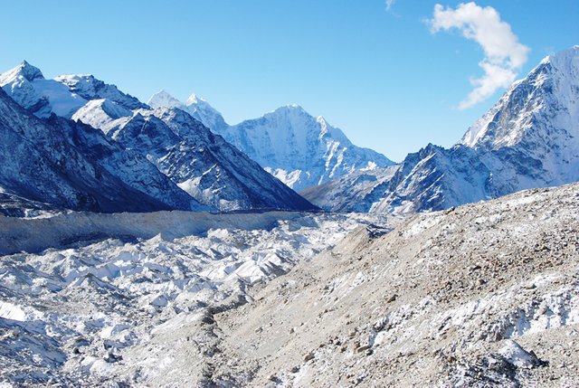
Khumbu glacier
Gorak Shep with the trail to Kala Patar
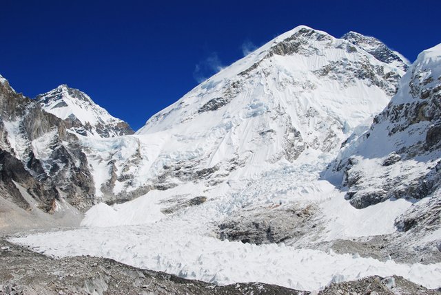
The glacier and the South Col
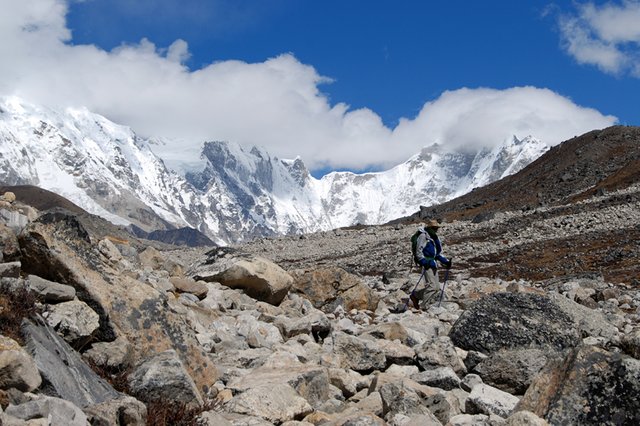
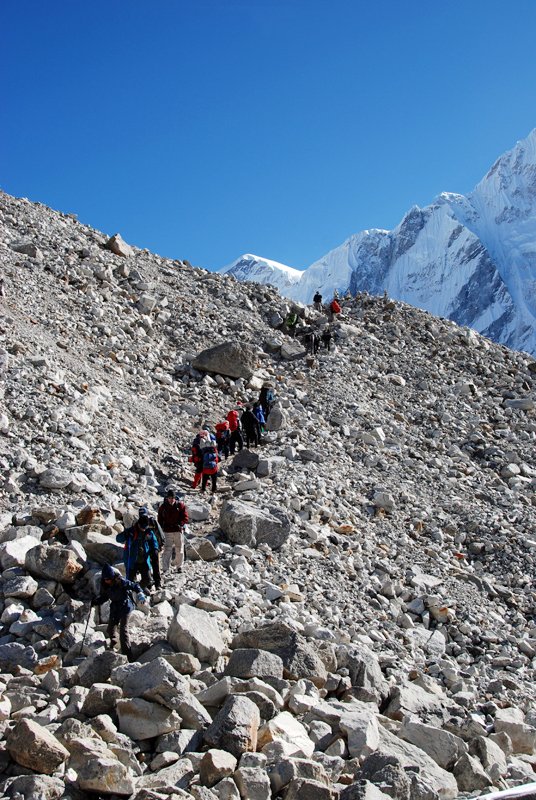
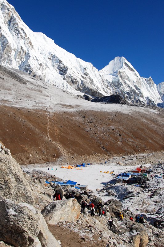
Day 8: Lobuche – Gorak Shep (5.170m) – Base Camp (5.300m) – Gorak shep
The hardest part. The distance itself is not long, but rocky terrain along with altitude made this a long and hard day. The last few kilometers was done only on willpower. It is not possible to see Everest from here, but the South Col of Everest, the starting point of climbing expeditions, is right in front. One can only imagine how it feels climbing up that glacier! A dramatic sight. I wondered how it must be to climb the mountain. Many trek from Gorak Shep to Kala Patar because the view of Everest is better from there. Back in Gorak Shep we did see the sun set on Everest.
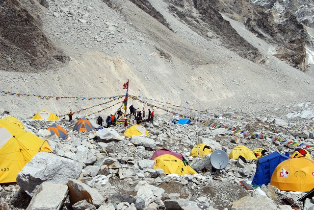
Everest Base Camp
Sunset on Everest
Day 9-12: Gorak Shep - Orsho (4.000m)– Namche Bazar – Phakding – Lukla
The way back to Lukla takes much less time, because of going downhill. We stayed one night in Orsho before crossing to the other side of the river the next day, visiting beautiful Tengboche monastery, which has been important to most Everest expeditions, starting with the one in 1953. The trail follows the river, more or less back at the starting point.
Walking through the village of Pherice
The last bridge
After spending so many days in the mountains, returning to “civilization” and the chaos and noise in Katmandu was almost a chock! My next trekking tour is Patagonia in 2019.
Please do follow if you want to keep up with my next travel story. Any upvotes or resteems are hugely appreciated!
Other travel stories, check out :
PALMYRA - ancient city in the syrian desert
MYANMAR - watching the world go by on the yangon circular railway
THE NAMIB DESERT - an otherworldly landscape
GREENLAND - continue to disko island (part 2)
GREENLAND - a world of ice and snow (part 1)
ILE AUX COCOS - an island in the sun (Roderique part 2)
THE ISLAND OF RODERIQUE - part 1 - a hidden gem in the indian ocean
THE ANCIENT TEMPLES OF BAGAN - from sunrise to sunset
AN ARCTIC ISLAND RETREAT – and one of the most extreme places
PORLWI BY NATURE – a cultural festival and a feast for the senses
«FOOD ON FOOT» - Street food in Hanoi
GHOSTTOWN – when people moved out, the sand moved in....
U.J
Kristiansand, Norway
All the photoes are mine, Ulla Jensen (flickr, Instagram and facebook)
[//]:# (!steemitworldmap 27.986715 lat 86.917421 long Mt. Everest Base Camp trek - walk among some of the highest mountains in the world d3scr)
Excellent article. What a great adventure! Thanks for these marvellous photos!
I'd like to ask you to participate in my Art Curation Initiative #5
Thank you :) leaving for Chile and Argentina in 2 weeks.....7 weeks of travelling.
I am jealous!! I love south america, and those are two countries I would love to visit!!
will check you Art Curation :)
This story was recommended by Steeve to its users and upvoted by one or more of them.
Check @steeveapp to learn more about Steeve, an AI-powered Steem interface.
This post was shared in the Curation Collective Discord community for curators, and upvoted and resteemed by the @c-squared community account after manual review.
@c-squared runs a community witness. Please consider using one of your witness votes on us here
Thank you so much!
This is very cool!
I have seen so much about Everest over the years. I think there was a time I may have desired to ascend it. I am not as ambitious anymore. This past summer I climbed up two very small mountains in Montana, and drove up two more. I realize how many great treasures are here much closer to home. And really, I felt lucky climbing these two mountains. The views were gorgeous, and I would not be surprised if many fewer have climbed them than Everest! So I will settle with my small adventures.
I think one day I would like to climb 2 or 3 of North America's tallest mountains. To do a camping trip with friends!
And ...after reading your comment about visiting South America... Reminded me of a trip I took up into the Andes Mountains...but by car. That IS a trek I would love to make on foot. The views on the way up were simply breathtaking!!!!
Thanks so much for sharing this with us!!!
Peace
Thanks for stopping by. I love hiking. Live in Norway with so many possiblities. Have been on top of many smaller mountains here, and of course the highest. In between I do go abroad, like treking in Nepal. My first top ascend was actually Kilimanjo in Africa. Once I had the ambition on doing Aconcaqua, but on my trip in a few weeks, I will setle for driving up and just a day trek. Have only been to Peru in South America. this will be my second to this continent. I am looking forward to see the Andes again :)
The dream about to get there is well spark even in Aceh Indonesia, our team just on prepare to go there, and expected to execute the plan in 2022. I wish I could joint the team. @digi-me you just made me jealous man!!
I hope you get the oportunity again. It was a real adventure. Stunning landscape. There is so much power in the feeling of standing in front of those mountains.
Congratulations, Your Post Has Been Added To The Steemit Worldmap!
Author link: http://steemitworldmap.com?author=digi-me
Post link: http://steemitworldmap.com?post=mt-everest-base-camp-trek-walk-among-some-of-the-highest-mountains-in-the-world
Want to have your post on the map too?
Dear @digi-me,
Thank you for the submission for our project – 1001 Places to Remember. Hooray, your story is now listed in our project publication, you can check through our progressive report either from our @fundition project page or @archisteem account. We will be sorting out the seasonal shortlist authors and make an announcement soon for the seasonal reward.
Stay tuned and Steem on!
@archisteem and team
Wow @digi-me, what a lovely view when i read your post. You been to Tibet. How you cope with it? The air in top always very thin. Not everyone can get used to it. The photo of yours in Dingboche, tthey painted the face in the stone? it so unique but sadly it lack of maintenance. With this trip of yours, need a lot of stamina. How long your team builded up the stamina before started the trip? I love the view from the top. It so lovely and I afraid of height. Photos is the only source to have a top view.
Lhasa in Tibet is about 4000 m. and you feel the air is thin. The first few days I had to take it easy. Walk slowly, but as we started to drive across Himalaya we did get used to it, but still had to walk slowly. But after 14 days in a hight between 4000 - 5200 m. I was acclimatized when I started the trek . I prepared by doing some walking at home before I went. The thing is to take it easy and walk slowly. That also gave us time to enjoy the view. To look at and walk among the mountains was so rewarding
A lot of people cannot proceed because of thin air. My friend told me, in tibet they sold medicine to help with that challenge. It must be great experienced and satisfaction of you able to conquer the mountain. Will you plan to go again if you have chance?
Posted using Partiko Android
Yes, they sell medicine in both Tibet and Nepal, but I was advised by my doctor to try to avoid it. Especially if, like me, I had to walk higher and higher. The effect of the medicine is that you do not notice the symptoms and therefor get altitude sickness without knowing it. The only thing that helps if you have serious symptoms, is to descend. And yes, I could do that trek again :) but first I am going to Patagonia on both the Argentinian side and the Chilean side. But it will not be any altitude to think of. Won't be climbing any mountains.
Oh.. I didn't aware of that. This was a very good advice from a doctor. I must remind my fried who plan to go there. When you walked higher and higher, do you feel headache or short of breath?
Posted using Partiko Android
Good idea to ask a doctor before going :) I felt short of breath, yes. If I walked too fast. But then I stopped or slowed down until breath was normal again. In Tibet I felt headache the first 2-3 days. I think it was because I arrived by flying in and landed directly on 4000 m. In Nepal I was fine. Hardly any symptoms.
Ah ok, normally they will take train. Then stop in middle of the village before proceed to go up. I hope one day i able to go there but worry of the pressure.
Posted using Partiko Android
Congratulations! Your high-quality travel content was selected by @travelfeed curator @for91days and earned you a reward, in form of a 100% upvote and a resteem. Your work really stands out! Your article now has a chance to get featured under the appropriate daily topic on our TravelFeed blog.
Thank you for being part of the TravelFeed community!
Learn more about our travel project on Steemit by clicking on the banner above and join our community on Discord
Thank you so much!
Hi digi-me,
Visit curiesteem.com or join the Curie Discord community to learn more.
Thank you so much!