(ENG-ITA) Some Projects: ideas and concepts. #8 DUNES, POND, SEA [by voiceoff]
#1_SIEGE!
#2_NARACAULI
#3_SO SMALL SO STRONG
#4_A MONSTER
#5_BURGOS CASTLE (1) Survey
#6_BURGOS CASTLE (2) Project
#7_OSIDDA
I decided to share some of my works and studies on #steemit. The main theme is nature, landscape architecture and restoration. I hope you like them.
In this eighth post I will speak mainly of territorial analysis and graphic representation.
In this eighth post I will speak mainly of territorial analysis and graphic representation.
Ho pensato di condividere con tutta la comunità di #steemit alcuni miei lavori e studi che hanno come tema principale l'architettura del paesaggio. Spero vi piacciano.
In questo nuovo post si parlerà principalmente di analisi territoriale e rappresentazione della stessa.
In questo nuovo post si parlerà principalmente di analisi territoriale e rappresentazione della stessa.
#8_ DUNES, POND, SEA
Orthophoto 2006
This time we are in Alghero, in the north-west Sardinian coast. In the presence of a very complex "ecosystem". It is a strip of land between the pond of the Calich and the sea.
In this strip of land you can find a bit of everything. Cultivated fields, areas for summer tourism (beach with pine trees behind), road links, sketched urban settlements, abandoned farmhouses, illegal landfills, etc. How to rearrange this chaos? The project should have answered this question but I personally have dealt with the preliminary analysis more than anything else and for this reason you will not find any project in this post.
In this strip of land you can find a bit of everything. Cultivated fields, areas for summer tourism (beach with pine trees behind), road links, sketched urban settlements, abandoned farmhouses, illegal landfills, etc. How to rearrange this chaos? The project should have answered this question but I personally have dealt with the preliminary analysis more than anything else and for this reason you will not find any project in this post.
Questa volta siamo ad Alghero, nella costa sarda nord-occidentale. Alla presenza di un ecosistema molto complesso. Si tratta di una striscia di terreno compresa fra lo stagno del Calich e il mare.
In questa striscia di terreno si può trovare un po' di tutto. Campi coltivati, aree per il turismo estivo (spiaggia con retrostante pineta), collegamenti viari, insediamenti urbani abbozzati, casolari abbandonati, discariche abusive, ecc. Come riordinare questo marasma? Il progetto avrebbe dovuto rispondere a questa domanda ma io, personalmente, mi sono occupato più che altro dell'analisi propedeutica e per questa ragione di seguito non troverete nessun progetto.
In questa striscia di terreno si può trovare un po' di tutto. Campi coltivati, aree per il turismo estivo (spiaggia con retrostante pineta), collegamenti viari, insediamenti urbani abbozzati, casolari abbandonati, discariche abusive, ecc. Come riordinare questo marasma? Il progetto avrebbe dovuto rispondere a questa domanda ma io, personalmente, mi sono occupato più che altro dell'analisi propedeutica e per questa ragione di seguito non troverete nessun progetto.

View of the gulf (photo of the author)
For the changing essence of the place, the first aspect that we wanted to analyze was the change over the last century of the aquatic borders.
Starting from the historical cartography, the perimeters of the waters were identified and overlapping them we found the areas with a marked "dynamic vocation".
It was not easy to find a right formula to graphically represent the "movement" but a solution was found.
Starting from the historical cartography, the perimeters of the waters were identified and overlapping them we found the areas with a marked "dynamic vocation".
It was not easy to find a right formula to graphically represent the "movement" but a solution was found.
Per l'essenza mutevole del luogo il primo aspetto che si è voluto andare ad analizzare è stato il cambiamento nel corso dell'ultimo secolo dei confini acquatici.
Partendo dalla cartografia storica si sono individuati i perimetri delle acque e sovrapponendoli si sono trovate le aree con una spiccata "vocazione dinamica".
Non è stato semplice trovare una giusta formula per rappresentare graficamente il "movimento" ma una soluzione è stata trovata.
Partendo dalla cartografia storica si sono individuati i perimetri delle acque e sovrapponendoli si sono trovate le aree con una spiccata "vocazione dinamica".
Non è stato semplice trovare una giusta formula per rappresentare graficamente il "movimento" ma una soluzione è stata trovata.
Historical evolution
Synthesis
In the historical series, the yellow highlights the areas where the earth invades the water, the red areas where the water invades the earth. In the next image, instead, a general overlap that allows a synthetic view of this continuous movement.
The same work has been done to the displacements of the dune band. Below.
The same work has been done to the displacements of the dune band. Below.
Nella serie storica il giallo evidenzia le aree dove la terra invade l'acqua, il rosso le aree dove l'acqua invade la terra. Nell'immagine successiva invece una sovrapposizione generale che consente di avere una visuale sintetica di questo continuo movimento.
Lo stesso lavoro è stato fatto per gli spostamenti della fascia dunale. Di seguito.
Lo stesso lavoro è stato fatto per gli spostamenti della fascia dunale. Di seguito.
Historical evolution
Synthesis
From the elaboration and the study of these movements one understands how they are due in large part to the action of man who has deeply affected the trend of the currents and the exchange of materials between water and earth. The construction of the port, the subsequent integration of the same with the large pier. The construction of the band landslides, the construction of the road and the various urbanizations that have affected the centers of Alghero and the nearby Fertilia. All elements that determine the current conditions of erosion of the beach in the north of the gulf, and growth of the beach and accumulation of materials in the southern belt.
Dall'elaborazione e dallo studio di questi movimenti si capisce come essi siano dovuti in gran parte all'azione dell'uomo che ha intaccato profondamente l'andamento delle correnti e lo scambio di materiali fra acqua e terra. La costruzione del porto, la successiva integrazione dello stesso col grande molo. La costruzione della fascia frangi flutti, la costruzione della strada e le varie urbanizzazioni che hanno interessato i centri di Alghero e della vicina Fertilia. Tutti elementi che determinano le condizioni odierne di erosione della spiaggia nel nord del golfo, e di crescita della spiaggia e accumulo di materiali nella fascia a sud.
Results of the analysis
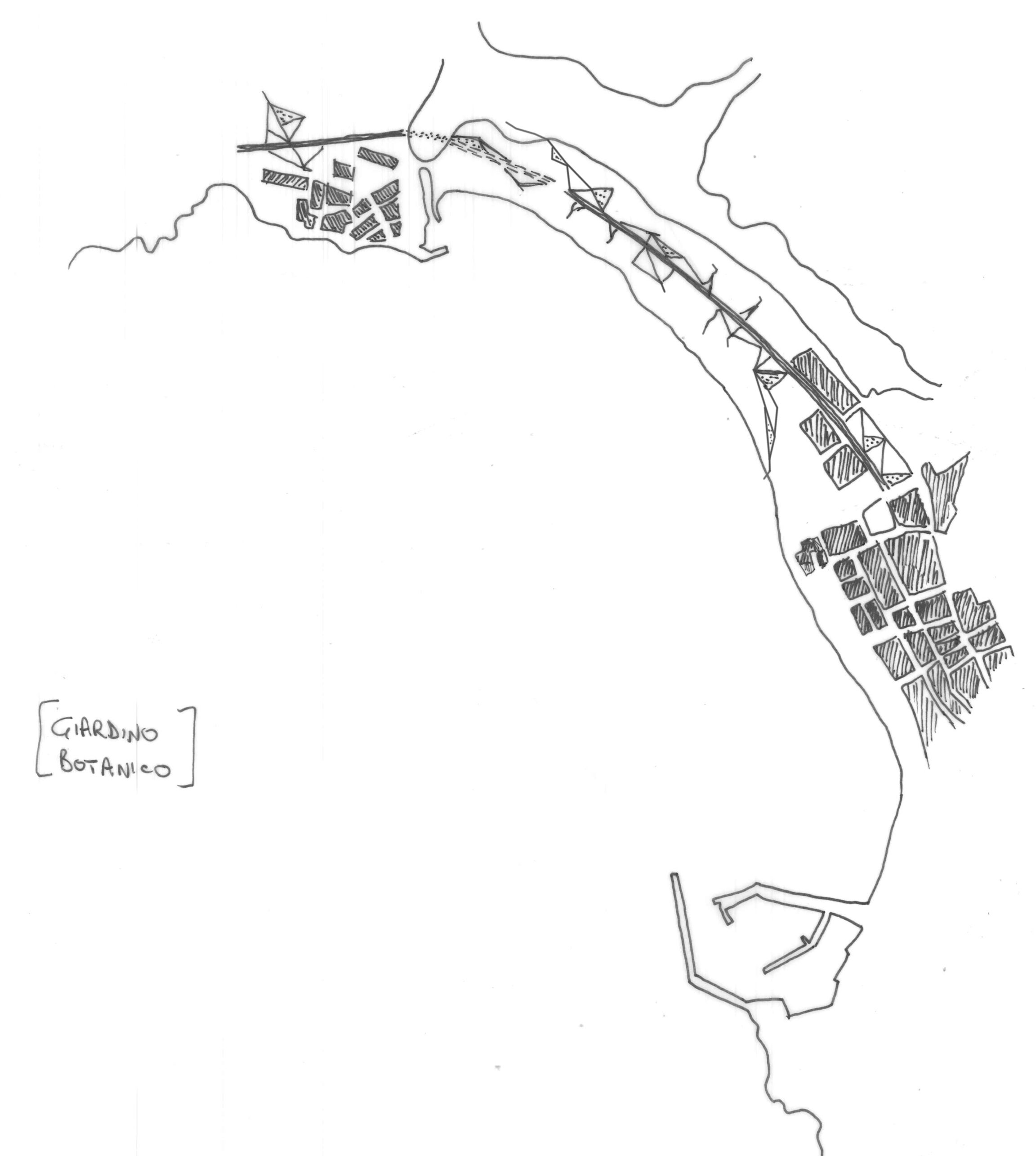
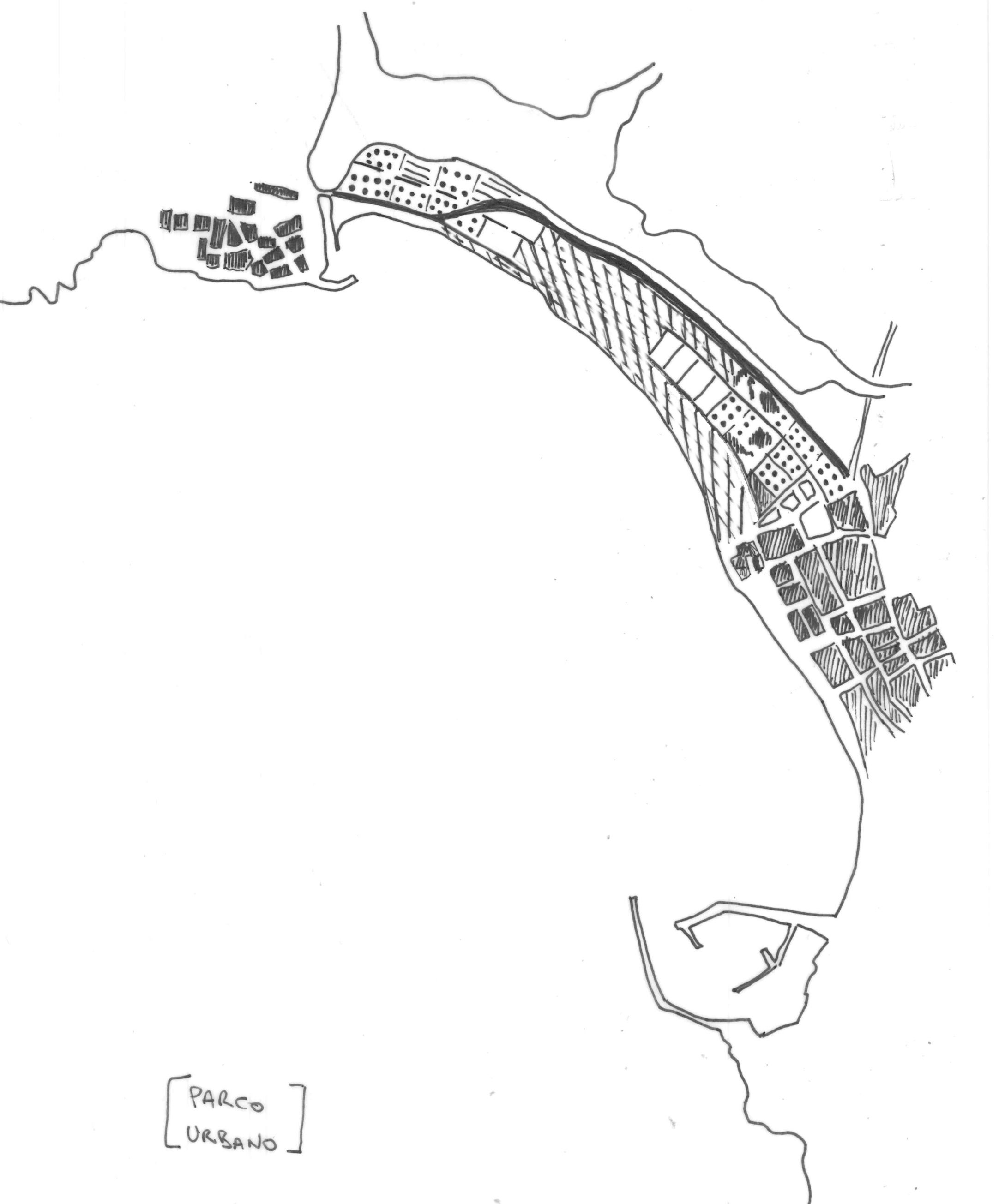
In this post I have summarized the various analytical steps a lot. Our working group has also dealt with economic and social aspects, population analysis, etc. All elements that were then used in the elaboration of the final note of this work that concerned the proposal of different project scenarios that would have to deepen another working group. They were 4, schematized in the 4 planimetric sketches that I report below. Where each of the 4 options does not exclude the other 3.
In questo post ho sintetizzato molto i vari passaggi analitici. Il nostro gruppo di lavoro si è anche occupato di aspetti economici e sociali, di popolazione ecc. Tutti elementi che sono poi stati utilizzati nell'elaborazione della postilla finale di questo lavoro che riguardava la proposta di differenti scenari progettuali che avrebbe dovuto approfondire un altro gruppo di lavoro. Furono 4, schematizzati nei 4 schizzi planimetrici che riporto di seguito. Dove ognuna delle 4 opzioni non esclude le altre 3.
Agritourism company
Fish farm and tourism
Botanical Garden
Urban park
References and bibliography
- Historical maps (revised) have been provided by the Municipality of Alghero and some can be found on the website of the Sardinia Region.
- Other information has been taken from the State Archives of Sassari and from the PUC (Municipal Urban Plan) of Alghero.
Ciao, se chiarisci l'attribuzione delle immagini e inserisci riferimenti bibliografici posso cercare di farti avere un voto da steemstem
ah... sai credevo non fosse roba che potesse rientrare in quel progetto. Comunque non saprei come venire incontro alle richieste. Non c'è bibliografia e le immagini sono tutte elaborazioni mie. L'unica è l'ortofoto iniziale che ovviamente è materiale libero che mette a disposizione la Regione... Comunque ora vedo che si può fare.
potresti mettere riferimenti storici, non so..sto' solo cercando di darti una mano ;)
Mi piace questo tuo arch-steemtism!
ma sì, penso che possano essere interessanti... non trovi tanta roba di questo tipo in giro.
Hey @voiceoff, thank you for sharing this amazing project! We would like to thank you for supporting @archisteem by continuously using our #archisteem tag. The Archisteem is all about forming a community that believes and strives for the betterment of the future built environment and we are proud to have you on board! Looking forward to more of your posts soon. Steem on!
In the meantime, we are currently running a project – 1001 Places to Remember. We would like to invite you to join the project as well by just submitting a story. You can read here to know more about it.
Congratulations, Your Post Has Been Added To The Steemit Worldmap!
Author link: http://steemitworldmap.com?author=voiceoff
Post link: http://steemitworldmap.com?post=eng-ita-some-projects-ideas-and-concepts-8-dunes-pond-sea-by-voiceoff
Want to have your post on the map too?
Amazing post! I love it. Hey UPVOTE my post: https://steemit.com/life/@cryptopaparazzi/chapter-one-let-there-be-the-man-and-there-was-a-man-let-there-be-a-woman-and-there-was-sex and FOLLOW ME and I ll do the same :)
Amazing post! I love it. Hey UPVOTE my post: https://steemit.com/life/@cryptopaparazzi/chapter-one-let-there-be-the-man-and-there-was-a-man-let-there-be-a-woman-and-there-was-sex and FOLLOW ME and I ll do the same :)
Amazing post! I love it. Hey UPVOTE my post: https://steemit.com/life/@cryptopaparazzi/chapter-one-let-there-be-the-man-and-there-was-a-man-let-there-be-a-woman-and-there-was-sex and FOLLOW ME and I ll do the same :)