Where Eagles Fly : Valley Of Fire and the Virgin Mountains National Natural Area
I lensed these interesting images while flying over the Mojave Desert area to the north of Lake Mead, Nevada while looking for interesting formations to film. The vivid splashes of vibrant colors filled the entire area with a bright glow which from the air had a soft warm quality to it. The closer I got the more intense the colors became.
The first image below is of the Valley of Fire State Park, while not a huge park at 46,000 acres (19,000 ha) it is a wonderful place to visit due to the remarkable Aztec Sandstone formations that vividly cover the area. Considered Nevada's oldest state park, (opening in 1935) Valley of Fire derives its name from its fiery multi-red colored sandstone rocks in the formation often appear to be on fire when reflecting the sun's rays.
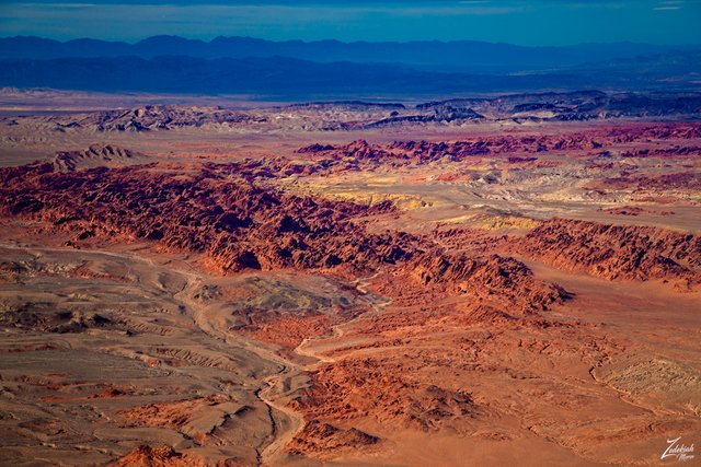 Valley Of Fire State Park ~ Click to Enlarge
In the above image; Valley of Fire Wash drains down through the center of the photo and on the bottom right of the wash lays Elephant Rock. To the left in the image is the formation known as the Seven Sisters and lying above the park, just next to those yellow colored formations is Baseline Mesa and the Silica Dome. The mountains lying just to the north of the park are called the Muddy Mountains.
These twisted jagged stones are some of the oldest natural rock formations known to mankind and the incredibly rough, stark red fossilized sandstone formations formed out of great shifting sand dunes during the age of dinosaurs 150 million years ago. They were created by a dramatic shift in the Earth's crust, then complex uplifting and faulting and followed by extensive wind and water erosion over time, which sculpted the land into what we see today. (Research Source)
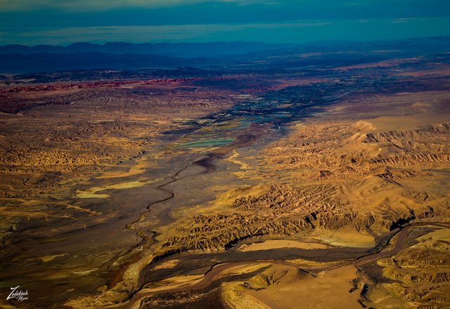 Moapa Valley & The Muddy River ~ Click to Enlarge
In the image above, the aptly named Muddy River flows down from the Muddy Mountains Wilderness through the Moapa Valley and south into Lake Mead. First Nations Tribes have occupied these mountains for thousands of years. They have left behind rock art, artifacts, agave roasting pits, and rock shelters.
Looking behind me I lensed this image below while over Red Rock Springs (in the bottom left foreground), while Lake Mead is in the top right of the image. This is an unusually harsh environment yet ancestral First Nations Anasazi People are thought to have migrated into the region about 300 B.C. and while here, survived on a mostly vegetarian diet consisting of all kinds of cactus and plants including yucca, mesquite tree, prickly pear and beaver tail.
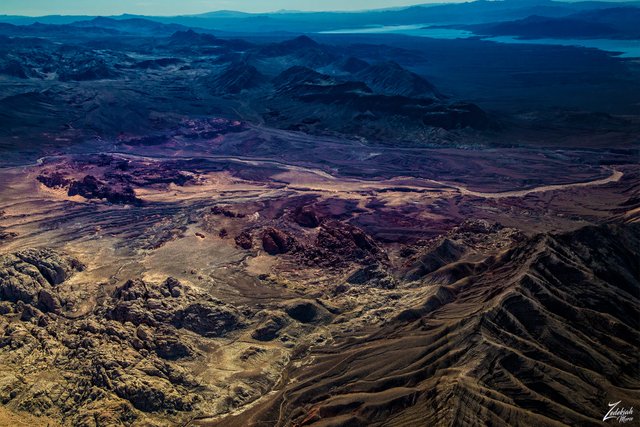 Red Rock Springs & Lake Mead ~ Click to Enlarge
Looking back to the north in the image below, this is part of the Virgin Mountains National Natural Area, part of the Gold Butte National Monument. The line of small hills on the left side of the image is called Black Ridge and where it joins the larger Virgin Mountains on the right side, that small peak in the middle of the two ranges is called Little Virgin Peak.
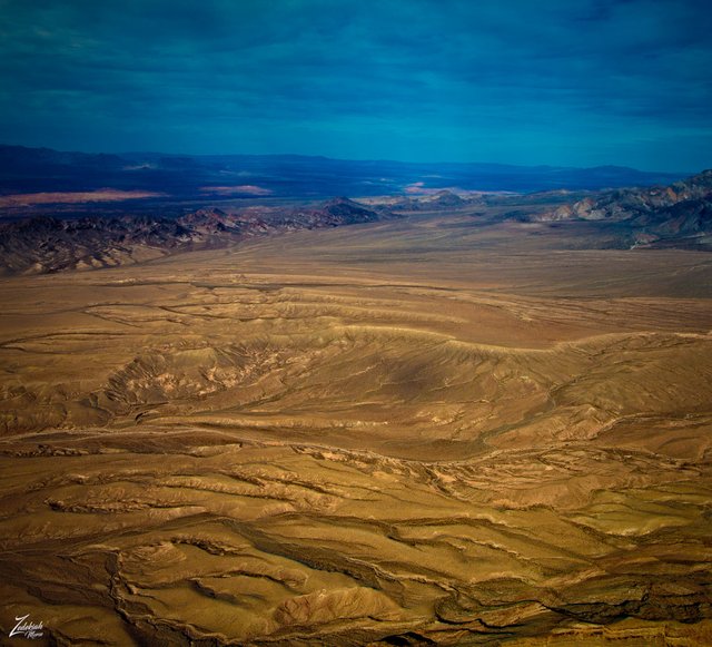 Black Ridge and Little Virgin Peak ~ Click to Enlarge
On the other side of the valley in this image above and below is the First Nations Moapa Indian Reservation. These are the descendants of the original people who occupied these lands for so long. As prehistoric users of the Valley of Fire this would have included the Ancient Pueblo Peoples, also known as the Anasazi, who were farmers from the nearby fertile Moapa Valley.
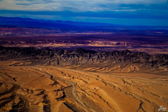 Black Ridge & Virgin River Wash
Eventually, they learned to plant corn and beans and hunt animals like rabbit, sheep and antelope. Their approximate span of occupation has been dated from 300 BC to 1150 AD. Their visits probably involved hunting, food gathering, and religious ceremonies, although scarcity of water would have limited their stay. Fine examples of rock art (petroglyphs) left by these ancient peoples can be found at several sites within the park.
(Research Source)
These days only wild animals dwell in Valley of Fire area year-round. Rattlesnakes, kangaroo rats, kit foxes, coyotes, bighorn sheep and the white tailed antelope ground squirrels are just a few of the animals that inhabit the area. (Research Source)
Here is a link to google maps for the location of this beautiful place.
I lensed these images while exploring this awe-inspiring wilderness area for my ongoing project, "Where Eagles Fly".
About The Project
Where Eagles Fly - The American Wilderness Expedition is my personal mission to introduce people to these amazing locations that surround us. I am piloting a bush plane while exploring and filming throughout the remote back-country areas of North America to raise awareness of the 47% of the USA and 90% of Canada that remain unpopulated wilderness.
About The Author
My name is Zedekiah Morse and I'm a Bush Pilot, Photographer, Explorer and Filmmaker. I live in the Rocky Mountains and devote my time and resources to exploring as much of the world as I can by air. If you wish to watch a short film detailing how I do my work and this project, go here.
If you like what you see here upvote and resteemit so that others may experience these wondrous places.
And if you'd like these images to be part of your feed, follow me.
Thanks for your support and Yehaw!!
Great pics , I flew over that area in a chopper last year on way to the canyon . Great views
Thanks ! Yep a couple years ago I was filming on my project at Pearce Ferry early in the morning. Had my remote cameras set up along the runway and looking out over the cliff so I could film the take offs and landings... I was doing a series of wide touch and goes around the small permitted flight area.
On my fourth cycle as I turned base to final I noticed 3 Papillion helicopters hovering off a slight ways watching me work. After the next cycle there were 5 and then on my last cycle there were 7 LOL!!!! I got on the radio and spoke to the pilots and everyone said the tourist passengers really enjoyed the show!! yehaw
That’s great. Some day I’ll get back into flying. I come from a family full of pilots. Cessnas and cherokees growing up cruising around Long Island !
You should!!! Most definitely get back into it. Times a wasting! We need more people flying for real. Less than 890,000 pilots in the entire planet! That includes commercial and military pilots in all countries worldwide.... its somewhere around 887,000 pilots. Out of 7+billion people..... wow - so please!!! Get back into it.... see you in the skies!
in these extreme conditions not only beautiful landscapes emerge but also amazing creatures
True that!!!! Thanks for taking time to check out my post!
Hi @skypilot,
I've enjoyed reading your post; these images show amazing views, which complemented with the detailed info provided, have transported me to ancient times. In my opinion, your Project's mission is being accomplished!
Thank you for sharing your work.
Wow, what a nice thing to say... and I am glad to see you understand my mission well! Thanks so much for taking time to read the post and write a comment. I really appreciate it.
nice shot
So beautiful photos, thanks for your share!
Good.. very amazing photography
Looks like a good trip. And I'm once again impressed with the equipment you're using. To get that crisp of a picture with so much detail while flying is impressive. I appreciate that not only do you show the pictures, you explain where it is and bits of what happened there. It feels more like a history lesson than a picture show. I enjoy learning new things, so that works well for me.
Thanks! It was an awesome trip for sure.... on getting the images sharp... that took a while to get down correctly. I have to tack into the shot... what I mean is that I have to cross control the aircraft to get it to crab or slip towards the scene I am shooting. Because the camera sensor is a rolling shutter there are delta motion artifacts which occur in the process of taking each single image. Remember I am moving through time and space when shooting the picture so this translates into delta motion. It is quite a challenge to take a seriously focused image so I thank you for realizing this!
I don't know what half of those words mean, so I'm even more impressed. I just know that if you want a clear picture of a car that is moving sideways, you have to move the camera with it a bit to get a clearer picture. If you don't, it will blur. What a fun way to spend your time though!
Great article ! I wouldn't mind hanging the first image somewhere on my wall, such strong contrasts and wonderful color balance 🙌
Just wondering, did you do any color grading on these images ?
Glad you enjoyed the article... many more to come. Sometimes I will dehaze an image if it is too cloudy but the colors are achieved using on-camera filters and polarizers. I try to match filters with the particular scene I am shooting for optimal effect. My goal is to try and naturally capture the scene and it is worth noting that I am shooting from a different perspective while in the air. There is much less particulate material floating around up there than you have to shoot through from on the ground where even the slightest inversion layer will cloud up the atmosphere you are shotting through.
I love the photo of Red Rock Springs & Lake Mead. It is stunning. Has Lake Mead regained it previous water levels? I know they had dropped significantly and there was some concern for the area.