Introducing Oman #1 : Dhofar's Popular Places
Hello Steamit
This year, I planned to start travelling, starting in Oman itself, where I was born and raised. I went to Dhofar, to visit Salalah. I have seen wonderful pictures and heard many great stories about how beautiful it is during the Khareef (Monsoon) season. It turns into a tourists paradise. We started at our journey at 23:00, so we could reach by next day afternoon, as it is almost 1100 KM away from Muscat. On our way, we have seen many travellers from Qatar, Kuwait, Bahrain, UAE and KSA come to visit Salalah in their vehicles (mostly 4x4, because the terrain can be rough). I am not good at narrating, so I will let the photos do the talking (mostly). I will cover Wadi Darbat, Taiq Sinkhole, Sumharam Archeological Park & Mughsail Beach. Hope you enjoy.
Camera : Samsung Galaxy S5
DAY 1

This photo was taken before Salalah. This town is known as Thumrait, and it used to be an important town during the times of Frankincense trade. The clouds don't cross the mountain. It was a breathtaking sight.


Once you enter the mountain, the vision reduces significantly. This is when you know you have entered a whole new world. This was the end of day 1 since we arrived at 14:00.
Day 2
Taiq Cave And Sinkhole
Location : https://goo.gl/maps/CT1oVUJNxj22


Taiq Sinkhole and Cave, 3rd Largest Sinkhole in the world
Facts:
-3rd largest sinkhole in the world (90 million m³ volume).
-36th deepest sinkhole in the world (250 m).
-1,000 m SSE-NNW direction width, 750 m NNE-SSW direction width.
One of the largest sinkholes of the world is the little known Taiq sinkhole in Oman.
Unique formation
At first look in "Google Earth" one might think that Taiq sinkhole is just a widening of the deep canyon of wadi - perennial stream. Such wadis in Oman often have shaped deep valleys and ravines.
Closer look though reveals - here is something unusual. This giant hole is not a part of valley. It is the endpoint of TWO streams who meet in the deepest point of this sinkhole and... dissappear underground.
In the surroundings of Taiq sinkhole there are several more interesting structures (look a bit to north-east). These are signs of large, collapsed underground voids. Such voids are created by underground streams, flowing through cave passages.
Giant size
The size of Taiq sinkhole is very impressive. Width of this structure in SSE-NNW direction is 1,000 m, in NNE-SSW direction - 750 m. Depth reaches 250 m, medium depth is 175 - 200 m. Volume of sinkhole is 90 million m³ - in this respect it belongs to the largest sinkholes of the world (the giant Xiaozhai Tiankeng (小寨天坑) sinkhole in China though is larger).
Walls around this sinkhole are very steep. In southern side walls of sinkhole have even 150 m high overhang.
Wadis - perennial streams - enter the sinkhole as very spectacular waterfalls. During heavier rain this should be very impressive, unusual place.
Formation
Most likely this sinkhole formed by the collapse of giant cave room. It is possible that this cave room was not as large as the current sinkhole and that sinkhole was later enlarged by two streams which enter it.
Just recently they discovered Taiq Cave - research is on-going and the results are told to be very exciting and impressive.
Nabi Ayub A.S. (Prophet Job) Tomb
Location : https://goo.gl/maps/ribh8udSj6D2


The tomb of Nabi Ayoub (or Job) is around 40 kilometres from Salalah on Jebal Ittin. There is a mosque and tomb where the remains of the Prophet, quite possibly Job from the Old Testament, are located.
There is a small garden to walk through to get to the tomb which is housed in a small building. Immediately next to the tomb are the walls of a small room used for prayer. The appearance is much like a mosque however the date of the life of the Prophet is pre-Islam. One section of the wall faces Jerusalem which is the direction the Prophet would face for prayer. Though his life is also pre-Judaism, even at that time he believed in the Oneness of God.
The story of Nabi Ayub : the Prophet is from Syria and had two wives. He had become very sick and the illness spanned over 15 years. During that time the exterior of his body became infested with worms. Nabi Ayub believed that his flesh was the food for these creatures of God and to show his devotion to God, he allowed the worms to eat of his flesh. If a worm would fall off, he would pick it back up and put it back on his flesh.
The sickness repulsed the people of Syria to the extent that he had to leave the area. Only one of his two wives chose to travel with him. The one who remained behind was as repulsed by his sickness and belief as were others who drove him away. The wife who remained with him was seemingly very supportive and accepting of his devotion to God. They left Syria and travelled to the mountain top where his remains now lie.
As stated, his sickness lasted over 15 years and at some point the worms began to eat inside his mouth. It was at this point that Nabi Ayub realized his breaking point and finally asked God for mercy. In response to this request, aware of the years of devotion and hardship, it is believed that God instructed Nabi Ayub to step out from his house and place his foot in a particular spot. When doing so a small hole in the ground opened up and from within the ground an outpouring of water occurred right next to his foot. God then instructed him to drink this water and upon doing so, he was not only cured of his sickness but his body, then at least 250 years old, was restored to the health of an 18 year old young man.
Nabi Ayub would then live until the age of 92 when he finally died and was put to rest in the very spot he dwelled all these years after his departure from Syria. Until now, Nabi Ayub's body remains in the same spot.
Just outside the entrance to the tomb is a small metal door on the ground. When opened you will find a footprint which has turned to stone. Measurements of the footprint we do not know but suffice it to say, it is quite large. This very footprint is believed to be the mark left on the ground when God instructed Nabi Ayoub to press his foot down. Just to the left of the footprint is a small hole in the ground where it is believed that the curing waters flowed from which he drank.
(Between the print of Nabi Ayub's right foot and the water hole is also a print from a horse though a story about why the hoof print is there was not revealed. Perhaps upon your visit to the burial sight you could inquire yourself)
The water no longer flows from this hole next to the footprint. It is dry. Until now, however, the water source which fed this hole upon God's command is located 1 kilometer down the mountain and there are no visible water trails that lead to the top. Seemingly, the water flowed up hill and inside the mountain to the very spot where Nabi Ayoub pressed his foot.
When you view the grave itself you will immediately notice it's largeness. It is approximately 13 feet long or nearly 4 meters and over 1 1/2 meters wide. And yes, his body was indeed this large as you will witness when you view the footprint. We asked the narrator on our visit about the reality of the body of the Prophet being as large as his grave appears and were told that it has been written that all those thousands of years ago people were large enough that they could easily reach out to a palm tree and eat of its fruits. Given the size of the footprint, the size could not be disputed!
Prophet Umran's Tomb

This extremely long tomb is situated in a pleasant small garden in the middle of Salalah. One walks up one side and down the other and that's it! Don't worry if your guide doesn't plan to take you there but if you have a spare 10 minutes then it's worth a look. As it is not authentic about the exact location of the burial place of Prophet Umran but still its worth a visit and pray on a prophet's tomb. Very little history and information available about the identity of prophet.
Prophet Hud's (Hood) Tomb

PROPHET HUD'S (Hood) TOMB, PEACE BE UPON HIM
The prevailing local belief states that the tomb of the prophet Hood is located in the Dhofar Mountains between hills, valley's, and water springs known as Hiryeh, Afileh, and Itham.
The three of them flow through the valled where the tomb is situated. The tomb is 3 meters long and 1.5 meters high. Prophet Hood was cited 7 times in the Holy Qur'an. He was sent to the Aad tribe in the Al Ahqaf region.
Arabic referenced defiant Al Ahqaf. Al Tabary said:"Al Ahqaf, plural of Haqf, Means sands creeping until they form a dune." 'Ata' Sais that Al Ahqaf is in the sands of Al Shahr land. Ibn Khaldoon said that Al Shahr, the Land of the frankincense where amber is found on its coast, is situated between Oman and Hadramout.
According to Ibn Katheer: "Al Ahqaf is the plural of Haqf, meaning the dune of sand, the land of the Aad tribe, their area dwellings near the sea were called Al Shahr and their fertile land is situated between Oman and Hadramout."
It is also said that Al Shahr is one of the numerous of ancient Dhofar.
Note: Al Ahqaf is known as "Ophir" in the other two holy books (Bibles).
Day 3
Mughsayl Beach
Location : https://goo.gl/maps/xhzGFuriW8T2


Al Mughsayl Beach (also written as Al Mughsail Beach) is probably the most famous tourist attraction in Dhofar. The beach is liked by the locals and tourists alike. Al Mughsayl is a long stretch of blue water sea and white sand. The landscape is pretty nice and the beach has mountains on both the sides, which make the view elegant and photogenic. It’s a perfect picnic spot. Huts at Mughsayl Beach are very traditional in style. The are made large enough to accommodate an entire family. Besides sitting area, the hut provides barbecue making area for grilling your lunch.
What to bring with you?
Mughsayl Beach is a perfect picnic spot. You can bring the following:
-Chairs / mats for sitting
-Lunch / food / refreshment items. Food item is not available nearby.
-If planning to make barbecue, then bring all items for the barbecue.
-Water and juices
-Sports items if with kids
-Sunblock cream / hats (For Summers)
-A good camera to capture the moment
Please be careful during monsoon season, as the waves are very strong and might cause you to drown.
Since Marneef cave and blow holes are located just besides Mughsayl beach, they are most of the times referred to as Mughsayl Blow Holes and are considered as a must to visit when at Mughsayl Beach.


The cave is at an altitude of around couple of feet from the ground. The access is through stairs or walkway with steep slope. Most of the time the security guard wont allow access to the caves.
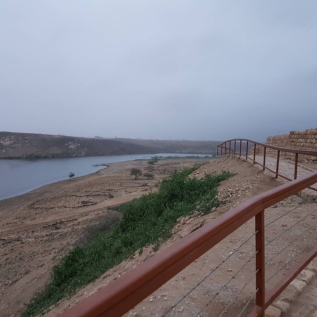
Sumhuram Archeological Park
Location : https://goo.gl/maps/x3De2oh1gv92
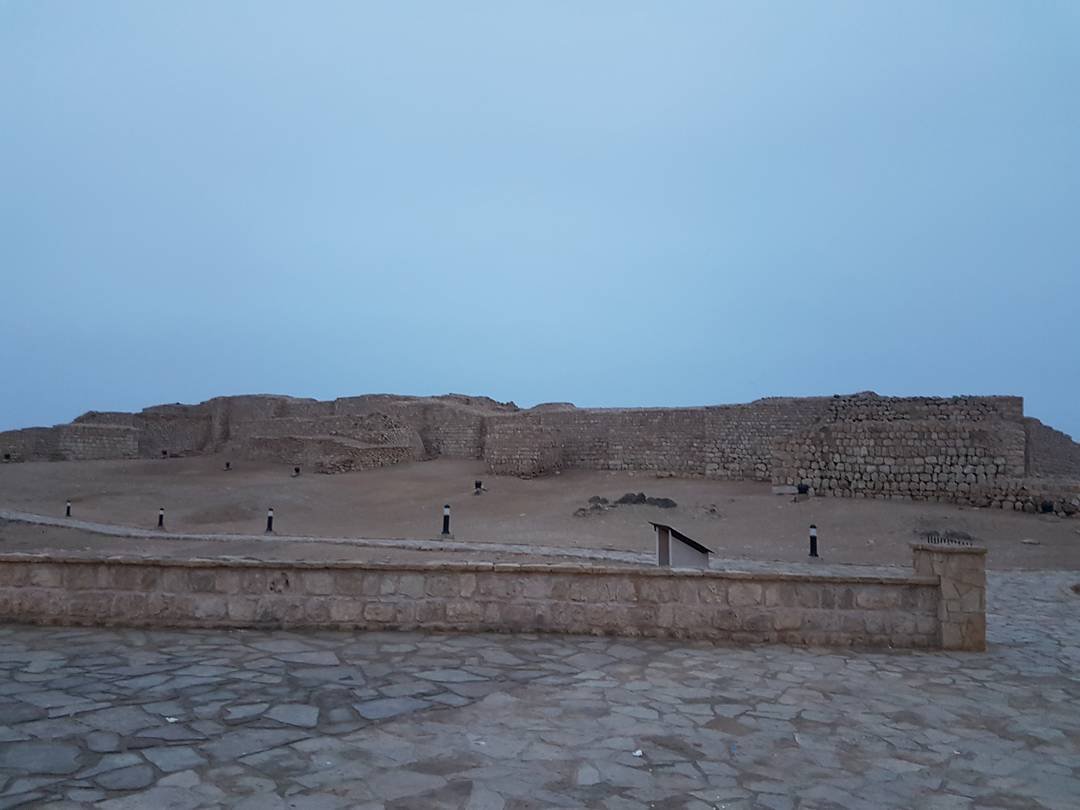


Back on the main coastal highway past the Wadi Darbat turning lie the absorbing remains of the old city of SUMHURAM, now protected as the Sumhuram Archeological Park. Along with the nearby city of Zafar, this was formerly one of the major ports of Southern Arabia and an important conduit for the international frankincense trade network. There are two wildly conflicting theories about the origins of the city based on the inscription found at the gateway.
This fascinating park is part museum and part archaeological site and you can wander around the ruins and watch the archaeologists at work. Visit the gallery within the site to see some of the 1st century BC to 3rd century AD finds from the site including some evocative Kursi inscriptions. There are toilets but no other facilities here.
Khor Rori is about 35km east of Salalah. Take the Mirbat road and follow the brown signs. A microbus to the junction on the highway is 500 baisa.
Khor Rorī (Arabic خور روري) is an Early South Arabian archaeological site near Salalah in the Dhofar region of modern Oman. The small fortified town was founded as an outpost for the kingdom of Ḥaḑramawt around the 1st century CE, but the site shows signs of Ḥaḑramite settlement back to the 2nd century BCE.[1] The settlement was probably abandoned in the seventh century.
Inscriptions at Khor Rori reports that the town, called "Sumhuram" (Old South Arabian s1mhrm), was founded on royal Hadramite initiative and settled by Ḥadramite emigrants. Dhofar was the main source of frankincense in the ancient period, and it seems likely that the foundation of the settlement was in part motivated by a Ḥaḑramite wish to control the production of this valuable commodity. Most scholars identify Khor Rori with the frankincense exporting port of Moscha Limen mentioned in this region in the 1st century CE merchants guide Periplus Maris Erythraei.
Khor Rorī / Sumhuram was first discovered by James Theodore Bent during his travels in the region in the late 19th century. The site has been excavated by the American Foundation for the Study of Man (AFSM) in the early 1950s and by the Italian Mission to Oman (IMTO) since 1994. The excavations have uncovered the ground plan of the settlement and has attested maritime contacts with the Ḥaḑramite homeland, India and the Mediterranean. It was inscribed in 2000, along with other sites along the Incense Route in Oman, as part of the UNESCO World Heritage Site "Land of Frankincense".
Some Mormon scholars believe that this is the "land Bountiful" where Nephi from the Book of Mormon stayed during his travels from Jerusalem (First Nephi chapter 17).
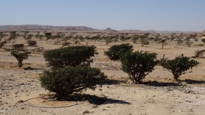
Wadi Darbat
Location : https://goo.gl/maps/FtYMXWM6SqH2


On the way


“Wadi Darbat” is the most beautiful and spectacular place in Salalah city for the mountain and spring lovers. The place is fully packed with tourists in the autumn season.
This wadi carves its way through hills and highlands until it reaches Khor Rori, where it empties into the Arabian Gulf. During autumn, the wadi’s water descending from the mountains forms magnificent waterfalls cascading from a height of up to 30 meters (100 feet).
“Wadi Darbat” is distinguished by its virgin nature and thick botanical cover, in addition to a natural spring and a number of caves. The wadi’s water is the source of the water filling Teeq Cave’s cells.
“Wadi Darbat” is located only a few kilometers behind Taqa, a beach city in Dofar Region. It is located on the left side on the road to Tawi Attir. From Taqa, there are a road sign to “Wadi Darbat”. Follow the tarmac road to the end of the valley, but be warned that you cannot drive freely through the entire valley.
The place offers everything that is needed for a memorable family day. You can enjoy with boat riding, Feeding fishes in the lake and you can easily place the BBQ grill, which is no other better place to have barbecue in the region other than “Wadi Darbat”.
There are a safety area is exclusively for kids for their safety, and several restaurants and huts that sell food, sweet corns, pop corns and fruits. You can also bring eatable items from any other market on the way.
Back in Ittin Valley

Madbhi Grill. This is cooking on hot stones.

Ittin Valley at night
This place was supposed to be a waterfall, but since it wasn't raining that time, there wasn't any.

The End.
Great Topic! Nice photos.
Thank you so much for taking the time to read. Love from Oman.
Congratulations @lightningfall! You received a personal award!
Click here to view your Board of Honor
Do not miss the last post from @steemitboard:
Congratulations @lightningfall! You received a personal award!
You can view your badges on your Steem Board and compare to others on the Steem Ranking
Vote for @Steemitboard as a witness to get one more award and increased upvotes!