Rethinking Street at Manila North Road (KM 37 + 800 to KM 43 + 000, McArthur Highway, City of Malolos, Bulacan)
Rethinking Street
This carefully planned blog, with technical analyses(based on gathered data) and some Computer-Aided Design recommendation, was made possible because of this realization: We need to reconfigure our cities and our streets to prioritize people and not cars. As a future Transportation Engineer, I am bound to think for the betterment of streets in our city.
After
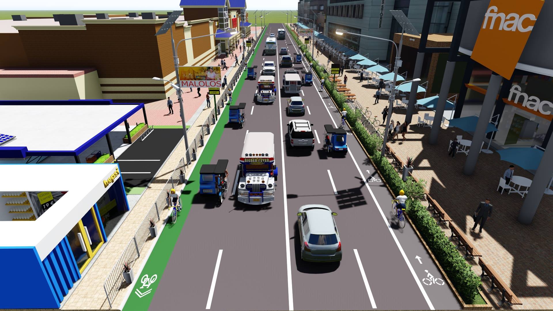
Design made using the software Google SketchUp and rendered using VRay 3.4
Before
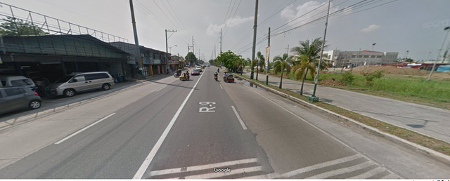
screenshot from Google Street View
TABLE OF CONTENTS
1.0 INTRODUCTION
----------1.1 PURPOSE OF THE REPORT
----------1.2 PROJECT OBJECTIVES
----------1.3 CONTENT OF THE REPORT
2.0 PROJECT AREA PROFILE
----------2.1 THE PROJECT STUDY AREA
----------2.1.1 Problems Encountered in the Selected road Segment
----------2.2 LOCATION AND LAND AREA
--------------------2.2.1 Existing Land Use
--------------------2.2.2 Demography
3.0 DATA GATHERING AND INVENTORY OF SELECTED ROAD SEGMENT
----------3.1 SELECTED ROAD SEGMENT
--------------------3.1.1 INVENTORY OF EXISTING FACILITIES
----------3.2 AVERAGE DAILY TRAFFIC (ADT)
--------------------3.2.1 HIGHWAY CAPACITY
--------------------3.2.2 GROSS DOMESTIC PRODUCT (GD
----------3.3 LINEAR REGRESSION
----------3.4 TRAFFIC FORECAST
4.0 ALTERNATIVES
----------4.1 OPTION 1
----------4.2 OPTION 2
5.0 KEY OUTCOMES OF THE CHOSEN ALTERNATIVE
REFERENCES
LIST OF FIGURES
Figure 1 Map of Study Area
Figure 2 Selected Road Segment
Figure 3 Existing Establishments
Figure 4 Typical Cross Section of Option 1
Figure 5 Front Elevation Option 1
Figure 6 Left Side Elevation Option 1
Figure 7 Right Side Elevation Option 1
Figure 8 Front Elevation of Option 2
Figure 9 Left Side Elevation of Option 2
Figure 10 Right Side Elevation of Option 2
LIST OF TABLES
Table 1 Historical ADT
Table 2 GDP Historical Trend
Table 3 Case 1: Using Total ADT
Table 4 Case 2: Deducting the Motorcycles on the Total ADT
1.0 INTRODUCTION
1.1 PURPOSE OF THIS BLOG
Roads are vital links that connects homes, jobs, leisure and all economic activities that support economic growth and social development to our communities. Road linkage’s serves as a backbone of our society that contributes to the overall growth of the Philippines which in turn contribute to our Gross Domestic Product (GDP). The GDP is an indicator whereby increase or decrease in the production of good and services provided in a year.
Referring to the references provided including but not limited to: Rethinking Streets and Cities Safer Design, the Project aims to determine and planned a suitable solution and viable recommendation to provide improvements and integrate environmentally suitable options that allows all road-users to have equal rights and share on the road networks provided by the Government. This blog is a collaborative effort to provide a suitable design to implement road diet solutions that will be reliable, sustainable, environment friendly and accommodate all road-users including motorcycles, tricycles, cycling, pedestrians and PWD’s for the selected road segment which will not impede the economic growth of the selected area.
1.2 PROJECT OBJECTIVES
The project aims to deliver that following objectives:
• To utilized the principle of Complete Streets in planning and determining potential solutions for road diets that can improve the traffic circulations, include street furniture, promote environment friendly and safe road corridors.
• To be able to present two (2) alternatives in improving the selected road segment based on the develop criteria and guidelines from lectures and reference materials.
• To propose a design that can integrate all road users including motorcycles, cycling, pedestrians, and PWD’s.
• To recommend the best option in developing the selected road segment that will promote sustainable design and safer road corridors.
1.3 CONTENT OF THE BLOG
This blog contains the following chapters with a brief description of each chapter’s contents:
• Chapter 1: Introduction – Provides a brief statement of the project and its objective.
• Chapter 2: Project Area Profile – Provides general description of (Malolos, Bulacan) the project study area of itssocio-economic profile, physical and natural environment and characteristics.
• Chapter 3: Inventory and Assessment – Provides that general background and description of the selected road segment including presentation of factual data gathered from relevant Government agencies which will be used in analyzing the future traffic and assessment in the actual road conditions and utilizations.
• Chapter 4: Alternatives– To provide a suitable road diets design that will incorporate acceptability to all road users that will provide necessary facilities including street furniture, motorcycles/tricycles lane, cycling facilities, SHARROW, pedestrians, and even PWD’s. Thus, alternatives presented shall be environment friendly and promotes safety to all road users.
• Chapter 5: Key Outcomes of the Chosen Alternative– Based on the careful planning and analysis, this blog will recommend the best option among the two (2) alternatives. The selected shall be recommended for implementation and citing its potential benefits and positive impact for the community.
2.0 PROJECT AREA PROFILE
2.1 THE PROJECT STUDY AREA
Malolos has been blessed by history with a lore that is so vital to the province of Bulacan and the nation during its formative years as a republic. Itwas here that the first legislative assembly was gathered (Malolos Congress). The gathering is a manifestation that Malolos was urban and a developingmunicipality during the time.This town ever since has actually been devoid of any development plan that would served as a blue prints for its physical growth, until 1978 when theland use plan was formulated by our Office and the Local Government of Malolos under the auspices of the National Coordinating Council for Town Planning, Housing and Zoning (NCC-TPHZ). This plan was ratified by the Human Settlements Regulatory Commission (HSRC) now the Housing Board(HLURB). This (Land use Plan) serves as a solid basis for balance land use allocation and development control in accordance with the approveddevelopment framework plan. The said plan though, has undergone several revisions and upgrading. The most recent is the 1992 approved plan was preparedin 1988 and is being implemented by the town.
This 1992 edition has served its purpose in making Malolos the more dynamic area of Bulacan.The advent of malls and food chain has caught up with the town and it is new a host to several of these new type of commercial development. Thiswill continue in the next decade and with the city hood in its horizon more and more establishment will be added to its cityscape.The 1996 revised plan hasembodied this dynamism and can fairly shape the future land use pattern for the city up to the year 2000 and beyond.Malolos, being proximate to Metro Manila, will feel the pressure of an expanding Metropolitan population. More subdivisions for residential, commercialand industrial uses will be located here because more people, trade and industry is likely to transfer their location to the periphery and Malolos is the mostconvenient area to absorb all this development.
The centennial celebration will have also an impact tothe growth of the town in terms of tourism and commerce. This had been considered in thisplan which by and large will add to the over-all settlement patterns for the future city.
2.1.1 Problems Encountered in the Selected road Segment
The following are the problems encountered in the Manila North Road selected segment:
• Poor Lighting on night time
• No dedicated bike lanes for cyclist
• Fading pavement markings
• Pedestrians not properly considered
2.2 LOCATION AND LAND AREA
The town of Malolos lies between 4 48’5” and 4 52’51” North Latitude, and 120 51’36” East Longitude. It is irregularly shaped and resembles anupright robust tree with an oversized trunk and with its eastern branches it growing it western counterpart.It is bounded on the North by the towns of Calumpit and Plaridel, on the East by Guiguinto and Bulacan, on the South by Manila Bay, and on theWest by Paombong. The town proper is about 42 kilometers north of Manila, about 39 kilometers via the railroad from the terminal of the PhilippineNational Railway at Tutuban and about 34 air kilometers north of Manila.Malolos has a land area of 7,725 hectares consisting 2804.83 hectares of agricultural land of which 2769.29 hectares are devoted specifically forrice, hectares of fishponds and the rest are road, residential, industrial areas, commercial areas, institutional areas, open spaces and waterways.
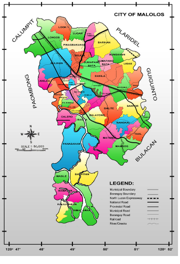
Figure 1 Map of Study Area
source : http://beta.maloloscity.gov.ph/index.php/government/history/basic-socio-economic-and-demographic-data
2.2.1 Existing Land Use
The existing general land use of the Municipality of Malolos consists of the following:
RESIDENTIAL - An area of 1,549.85 hectares or 20.06 percent account for residential uses in all barangays. Mostly along the transport linesor road ways and the development of different subdivision. However, built individually apart from the settlement cluster and are interspersed with other land uses. The physical profile of the area reveals a contemporary and modern architectural designs with wood and concrete as the major structure components.
COMMERCIAL - The existing commercial uses is approximately 136.33 hectares or 1.77 percent of the total land area. Almost all commercial activities are done in the Central Business District and along the Mcarthur Highway and other major roads.
INSTITUTIONAL - The existing institutional uses is about 106.40 hectares or 1.38 percent of the total land area. The structural composition ofthe institutional are made up of national and municipal government offices, health institutions, private and public schools and churches which is located within the different barangays in the municipality.
INDUSTRIAL - The industrial uses which consists of garment factories, rice mills ice plant and some medium scale industries has areal share of 137.40 hectares of 1.78 percent of the total land area. This industrial establishment is located in the different barangays, especially in barangays Tikay and Santor where the First Bulacan Industrial City is located.
OPEN SPACE - The total area for this use is about 389.95 hectares or 5.04 percent of the total land area. This includes parks and playgrounds cemeteries, roads, (public and private) and waterways in the municipality.
AGRICULTURAL/ FISH PONDS -The remaining area which has an area of 3502.87 hectares and 1902.20 hectares goes to agricultural andfish ponds uses covers 45.35 percent and 24.62 percent of the total land area of the Municipality.
2.2.2 Demography
POPULATION SIZE AND GROWTH - The 1995 NSCO report shows that the municipality of Malolos has a total population of 147,414 which is 8.28% of the total population of the whole province of Bulacan which is 1,505,219.Compared with municipality’s population in 1990 of 125,178, the population showed an increased of 22,236 persons in 1995 or an annual growth rate of 1.0365.
POPULATION DENSITY - The population density of the Municipality in the year 1995 is registered at 19.081 persons hectare.
POPULATION DISTRIBUTION - The NCSO Preliminary report of 1995 total population shows that the Municipality is entirely an urban area. It is presently composed of fifty one (51) urban barangays. Among the leading densely populated barangays are Mojon with 9,165 population, Bulihan with 7,227 and Sto. Rosario with 7,156. On the other hand barangays Bangkal, Niugan, Caliligawan, and Masile comprise the lies densely populated areas in the municipality.
SEX & STRUCTURE - Like the rest of the country, the young population of Malolos exhibits a pyramid age structure. The population between the ages under 1 to 14 account for 50,030 or 35.94% of the total population of 147,414 in 1995. On the other hand 91,749 or 62.24% belong to the 15 to 64 years old age bracket only 5635 or 3.82% are in the age bracket of 65 years old and above. In terms of sex distribution the female population slightly outnumbered the male population by 1.01% in the 1990. There are 73,336 male as against 74,078 females which gives us a sex ratio of 1:01 female per 1:0 male.
3.0 DATA GATHERING AND INVENTORY OF SELECTED ROAD SEGMENT
The Project Team allotted several days in gathering of actual data from various government agencies including DPWH, LGU and other relevant sources to determine the factual data that will be used in assessing and analyzing the strategy in developing the selected road segment.
3.1 SELECTED ROAD SEGMENT
The chosen road segment is portion of the Manila North Road which start at Km37+800 (Bulacan Arc) to Km43+000 (Malolos Intersection Bypass Bridge) with a total length of 5.2 kilometers.
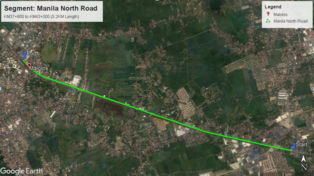
Figure 2 Selected Road Segment
source : screenshot from Google Earth
3.1.1 INVENTORY OF EXISTING FACILITIES
Majority of the study area are occupied by commercial and business establishments which induced traffic congestion on the area. Provision for ample parking and setbacks are not properly observed. Shown in Figure 3 are the areas of interest which cause traffic congestion on the road segment especially during rush hours. Several constructions can be seen on the area which causes additional impact and traffic congestion. Thus, the LGU should priority and observe proper urban planning to improve the road networks and linkage’s on the area which will promote better economic activities.
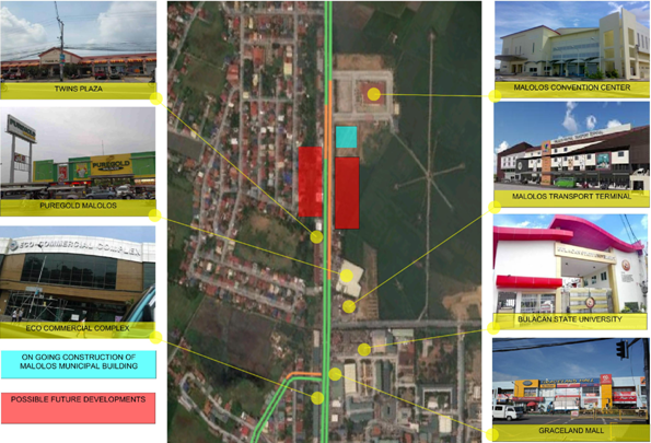
Figure 3 Existing Establishments
source: Google Earth
3.2 AVERAGE DAILY TRAFFIC (ADT)
The DPWH had provided me with the historical data of the selected segment which was used in determining the future forecast to verify the need to reconfigure the streets usage and allotment for road users. As shown in the Table 1 below, the DPWH had provided six (6) years of historical ADT which can be observed to be increasing.
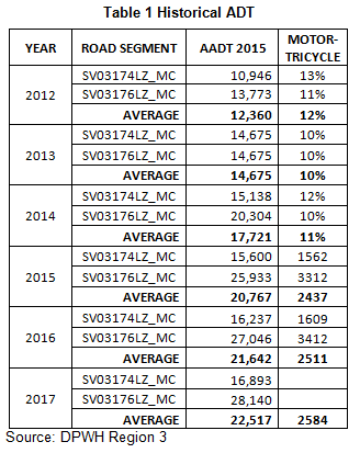
screenshot from MS Word. I don't know how to create tables in steemit.
Data given by this DPWH office to me.
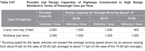
3.2.1 HIGHWAY CAPACITY
Based on the DPWH-DGCS and the excerpt provided below, I will adapt a vehicle per lane capacity of 1500 vehicles/hour.
3.2.2 GROSS DOMESTIC PRODUCT (GDP)
In order to determine the future forecast, the Philippine GDP was used to determine the correlation of the ADT against the GDP based on constant 2000 prices. Shown in Table 2 is the historical GDP trend.
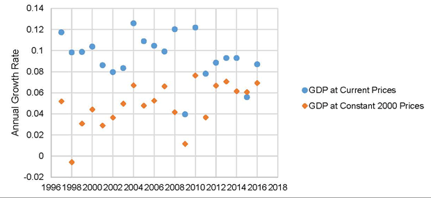
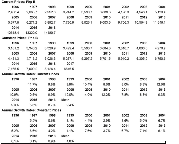
Table 2 GDP Historical Trend
Source: Bangko Sentral ng Pilipinas (BSP)
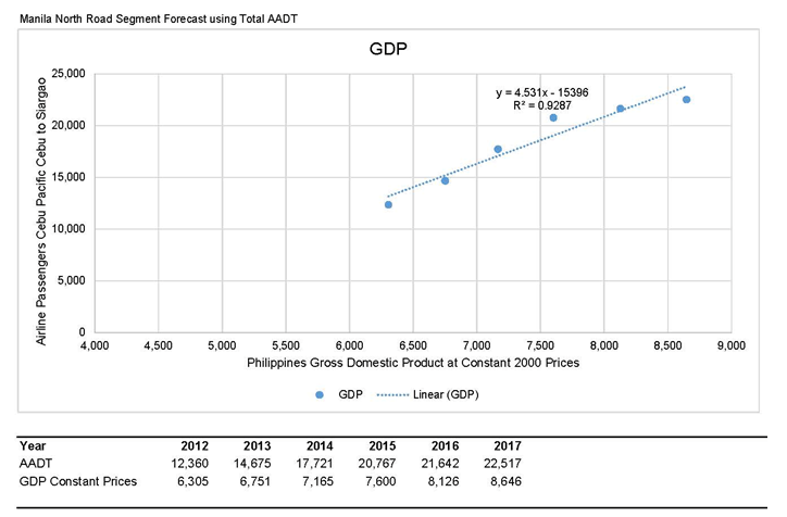
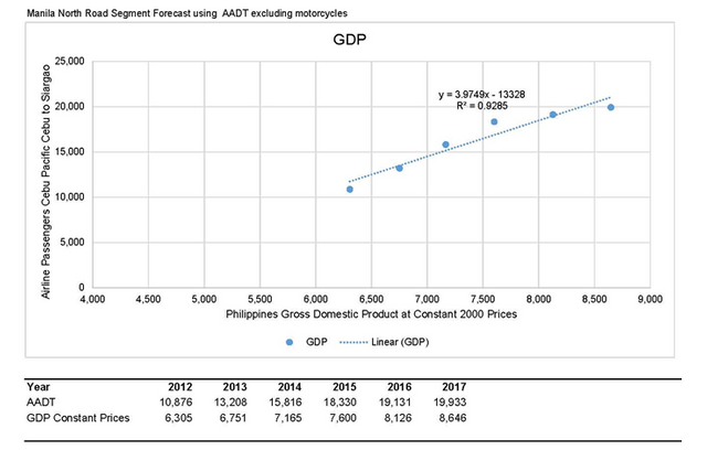
3.3 LINEAR REGRESSION
The analyses for the future traffic forecast are based on two case scenarios:
Case 1 - Using the Total ADT
Case 2 - Deducting the motorcycle on the Total ADT
Case 1 - Using the Total ADT:
Case 2 - Deducting the motorcycle on the Total ADT:
3.4 TRAFFIC FORECAST
Based on the presented graphs and result of the linear regression, both analysis have high values of R2, which means there is a good correlation of values. Since the range of motorcycle values ranges from 10% - 13%, the forecast is almost similar. The reason we excluding the motorcycle in determining the forecast is that they are considered as one (1) vehicle unit which will occupy the road which in the actual case can be trimmed down or provide a designated place so that traffic circulation and traffic flow can be improve.
Moreover, based on the table presented below, there difference is only on the number of years before they will reach double the present ADT which will require proper attention and future planning in order to avoid the problems it may induced in the future growth and transport situation in the Municipality of Malolos. For Case 1, it will only take seven (7) years to reach double the ADT. While, for Case 2, it will take nine (9) years to reach double the ADT.
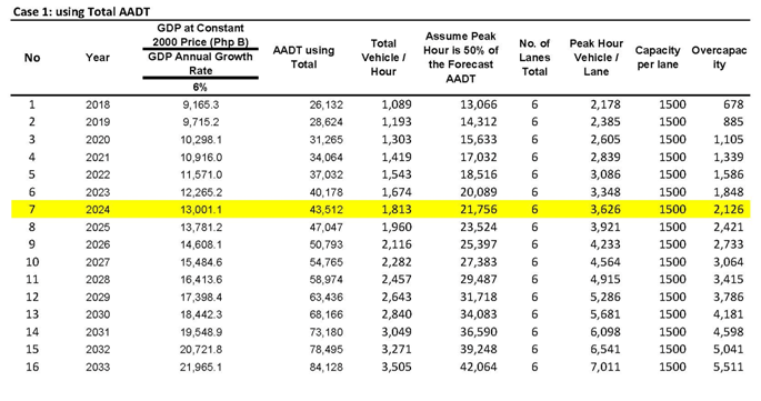
Table 3 Case 1: Using Total ADT
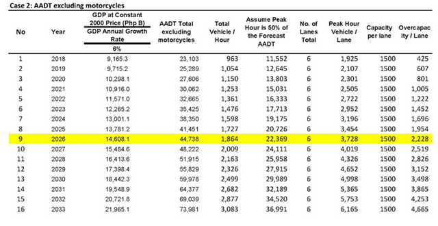
Table 4 Case 2: Deducting the Motorcycles on the Total ADT
4.0 ALTERNATIVES
I will present two (2) alternatives in developing the selected road segment that can improve the traffic flow, traffic circulation, road furniture’s, safety, integration of all road users, road diet and etc.The existing road right of way of twenty (20) meters for the entire chosen segment was reconfigured based on the presentation and references using the Complete Streets module and guidelines.
Considering the two (2) options presented below, the formulation and analysis of the inclusion of road furniture’s, road utilization, road users integration and etc. were based on the available data gathered from various agencies which aids in developing conceptual schemes and road layout.
4.1 OPTION 1
This option presents the following revision in the road layout including the following items:
• Provision of bike lanes / motorcycles on the outermost lane (both direction)
• Provision of sidewalk barriers for pedestrians protections
• Improvement of road setback and easement of business and nearby establishments
• Inclusion of road furniture’s and improve pedestrian locations
• Inclusion of proper road lighting and installation of cctv facilities
• Grade separation of pedestrian by providing footbridge on busy and heavy footwalk areas
The major advantages of providing the bike lane on the outermost lane will be provide better security and organized flow for cyclist and motorcycles which in effect will increase the traffic flow in the road segment. Because of this development, road discipline and vehicular accident can be lessen which will provide positive impact on the area.
The provision of road lighting and 24 hour cctv monitoring will improve the road segment on many accounts including but not limited to: rapid response during emergency and vehicular accident, provide quick response on road violators and crime prevention, increase factor of safety to road users and pedestrians and etc.
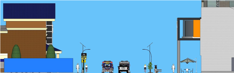
Figure 4 Typical Cross Section of Option 1
Created Using Google SketchUp without Render
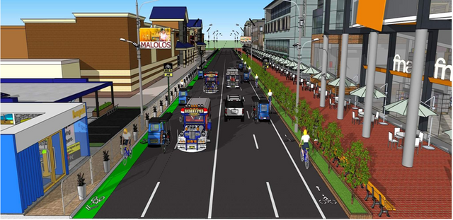
Figure 5 Front Elevation Option 1
Created Using Google SketchUp without render

Figure 5 Front Elevation Option 1
Created Using Google SketchUp and Vray 3.4 for render
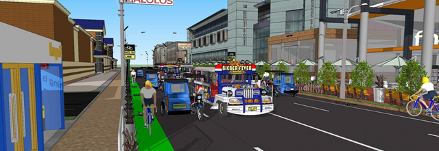
Figure 6 Left Side Elevation Option 1
Created Using Google SketchUp without render
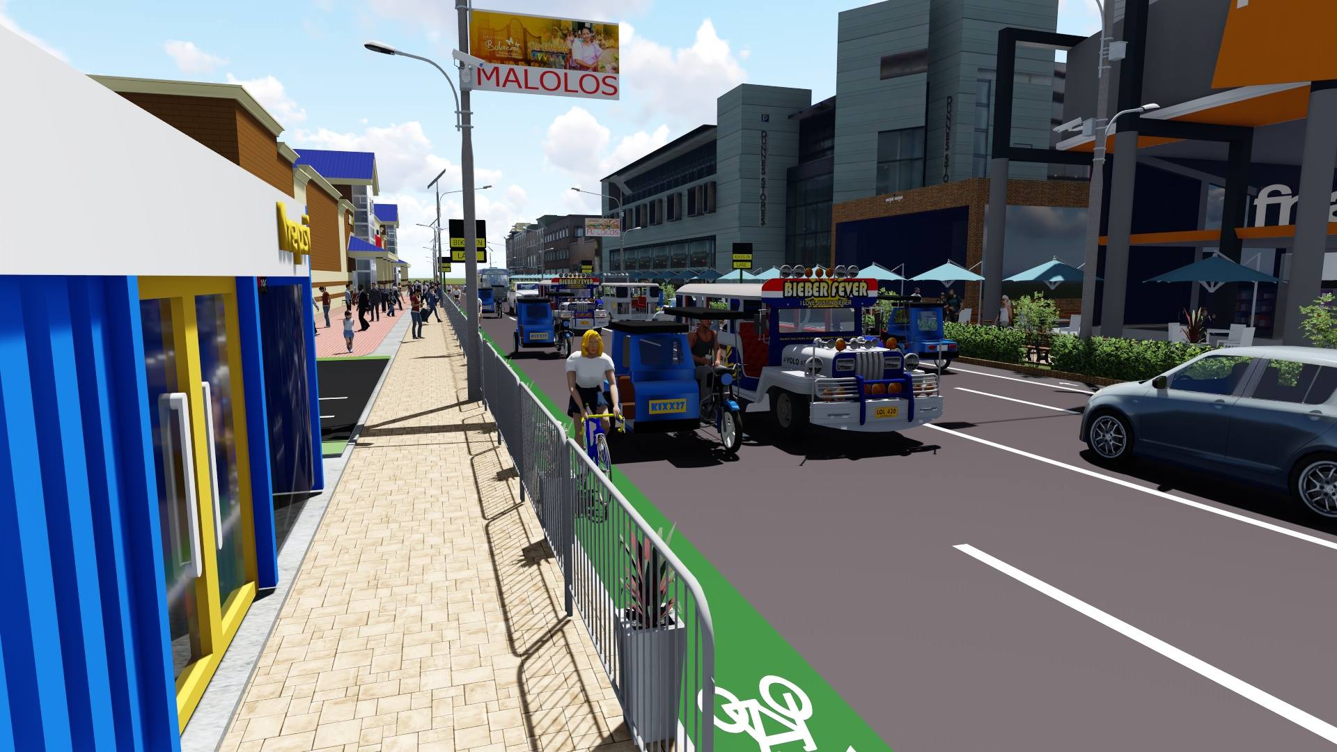
Figure 6 Left Side Elevation Option 1
Created Using Google SketchUp and Vray 3.4 for render
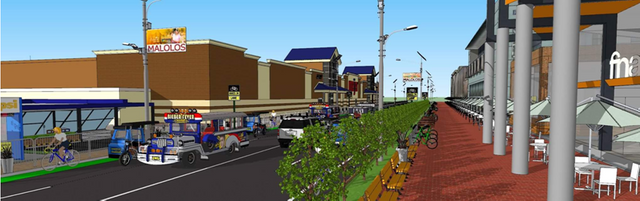
Figure 7 Right Side Elevation Option 1
Created Using Google SketchUp without render
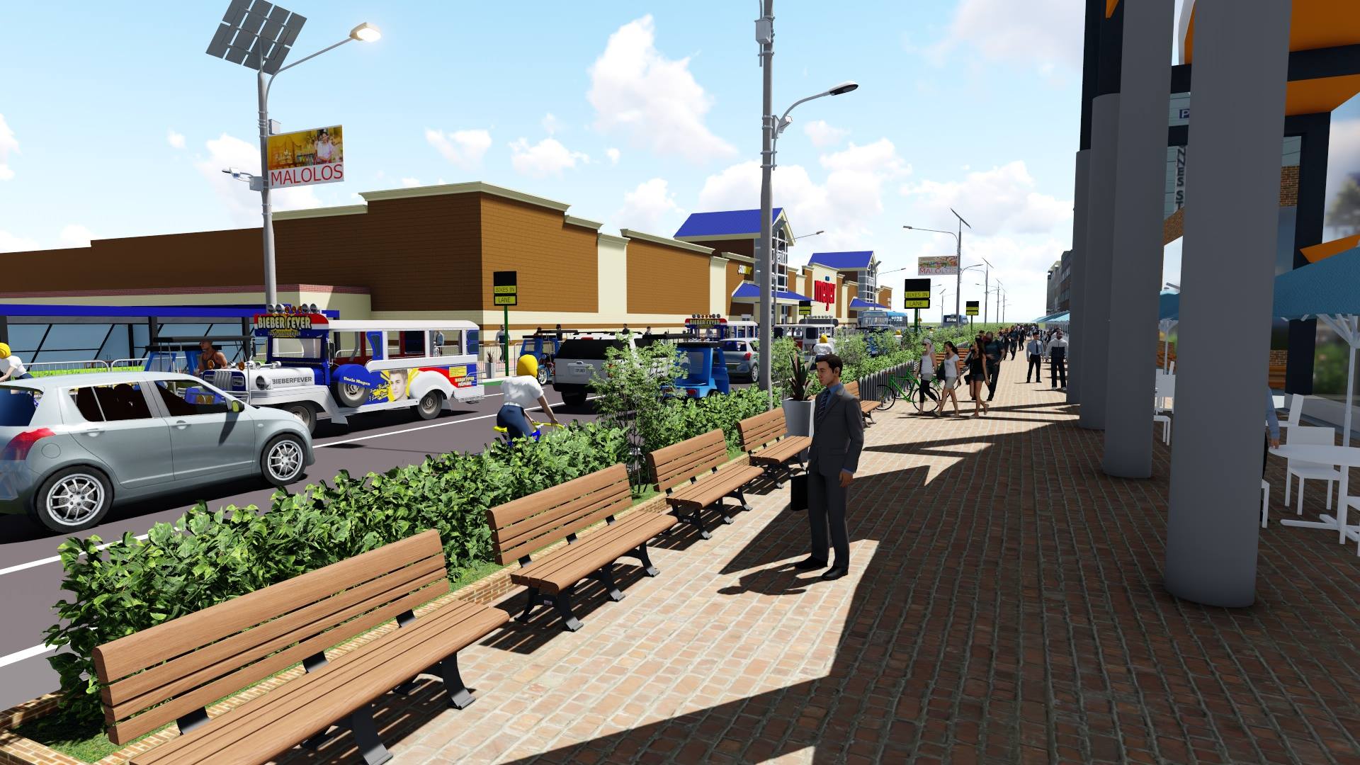
Figure 7 Right Side Elevation Option 1
Created Using Google SketchUp and Vray 3.4 for render
4.2 OPTION 2
This option presents the following revision in the road layout including the following items:
• Provision of street side parking
• Provision of bike lanes / motorcycles on the middle lane (both direction)
• Provision of sidewalk barriers for pedestrians protections
• Improvement of road setback and easement of business and nearby establishments
• Inclusion of road furniture’s and improve pedestrian locations
• Inclusion of proper road lighting and installation of cctv facilities
• Grade separation of pedestrian by providing footbridge on busy and heavy footwalk areas
The provision of on street parking will greatly affect the highway capacity of the chosen road segment based on the traffic forecast presented on Chapter 3. It will lessen the vehicular flow and will further induced traffic congestion. The provision of on-street parking must be discourage since it will bring more disadvantages to the road users and traffic enforcement in the area. Parking provision shall be included and address by business establishments in the area and not by the Government.
The location of the bicycle lane on the middle lane may danger the cyclist due to the speed of the cars passing on the inner lanes which may almost impede the vehicle flow of the two (2) main thoroughfares. Accidents are susceptible and impose road dangers on pedestrian and road users due to the on street parking. Vehicle flow will be lessen due to road friction converging road users on limited carriageway.
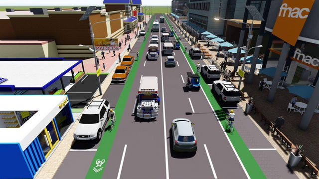
Figure 8 Front Elevation of Option 2
Created Using Google SketchUp and Vray 3.4 for render
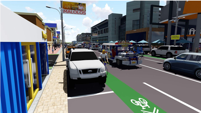
Figure 9 Left Side Elevation of Option 2
Created Using Google SketchUp and Vray 3.4 for render
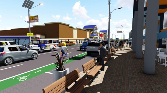
Figure 10 Right Side Elevation of Option 2
Created Using Google SketchUp and Vray 3.4 for render
5.0 KEY OUTCOMES OF THE CHOSEN ALTERNATIVE
This blog recommends the OPTION 1 since of the following advantages and positive impact that it can bring for the project. Listed below are the following:
• Increased Cycling Activities: Providing a safe corridor for cyclist will promote safety and health benefits. Thus, during weekends they will engage in such activities thereby generating revenues for nearby establishments.
• Definite Traffic Flow: If LGU will impose ordinances and monitor traffic guidelines and circulation. Motorists will have a define frame of mind while traversing the studied corridor. Integration to all type of motorist can be observed and violation and traffic apprehension will be lessen.
• Safety for Pedestrians: Providing a grade separation and barricade for pedestrians increases their safety at any time of the day. PWD’s and Senior Citizens can cross paths without impeding the traffic flow and pressure from the motorist. Proper maintenance and road furniture’s shall be installed or improve when necessary
• Increase Vehicular Traffic: Other than the boost in economic activity in the area due to the upcoming presence of the North Rail Project. If properly implemented, it will attract road users traversing nearby towns that must be validated by road surveys. Periodic calibration of the data and statistics shall be considered in altering and improving problematic road segments that are not foreseen during the planning stage.
• Dedicated Lanes: By providing lanes for cyclist and motorcycles, lane separation will provide increase in traffic speed that will reduced the traffic. However, speed limit shall be applied for this segment since there is a heavy dense of residential and commercial establishments.
• Continuous Flow: By providing a dedicated loading/unloading bays outside the main carriageway will provide continuous vehicle flow along the road segment. Traffic congestion will be mitigated and decrease in travel time can be achieved.
• LGU Enforcement: Providing adequate traffic enforcers on the segment will increase the safety and reduce the traffic congestion on certain road sections. The increase in economic activity on this road segment can put a premium for the LGU by requiring those establishment of increase taxation to fund for the salary of assigned traffic personnel.
REFERENCES
Department of Public Works and Highways(DPWH) – Average Daily Traffic (ADT), 2012-2017
Department of Public Works and Highways (DPWH) – Design Criteria, Guidelines and Standards (DGCS), 2015
BangkoSentral ng Pilipinas (BSP) – Gross Domestic Product (GDP), 1996-2017
Municipality of Malolos – Socio-Economic Profile, 2000
-Engr. Dominic N. Baltazar CE,RMP
University Of Philippines Diliman
MSCE-Transportation Engineering(Student)
2017-90998
Thanks for reading! I will submit this study to the City Hall of Malolos,Bulacan. I am hoping they will consider this proposal.
p.s. all contents are mine except photos with disclaimer(sources specified)
ang lupet! 😱 Engineer na engineer ang datingan. Haha
Haha panggap lang po
To listen to the audio version of this article click on the play image.

Brought to you by @tts. If you find it useful please consider upvote this reply.
Nice one, engineer!❤️
Thanks doc! <3
Sana tanggapin! 😃 Galing! Hahahahha
galing ....Engineer @dombaltazar...!!!pwedeng pwede
Congratulations @dombaltazar! You received a personal award!
Click here to view your Board
Do not miss the last post from @steemitboard:
Congratulations @dombaltazar! You received a personal award!
You can view your badges on your Steem Board and compare to others on the Steem Ranking
Vote for @Steemitboard as a witness to get one more award and increased upvotes!