Above 3900m || Lantang Trek || (Video, Timelapse, Panoramas)
We finally reached our final stop i.e. Kyanjing Gompa(3900m) and we were still uncertain of the weather. It was a hard time trekking due to unexpected monsoon, landslides and leeches along the way. But when we finally reached the destination, it was totally worth the risk. And this post is all about how it was worth the risk.
So fasten your seat-belts for the most memorable post that you might ever see. Your will get to see everything that i did above 3900m and i will ask you all to hold your tears(I couldn't actually!).
It was a hard and a rainy the day before(Check out my post worth it) and we had no hopes for this day as well. So we had already made a decision that we wouldn't trek higher to Kyanjing Ri(4300m).
But we woke up to a surprise. The weather was all clear when it mattered the most. So we decided to a further trek. And it was the most memorable day we ever had.
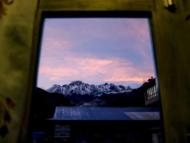
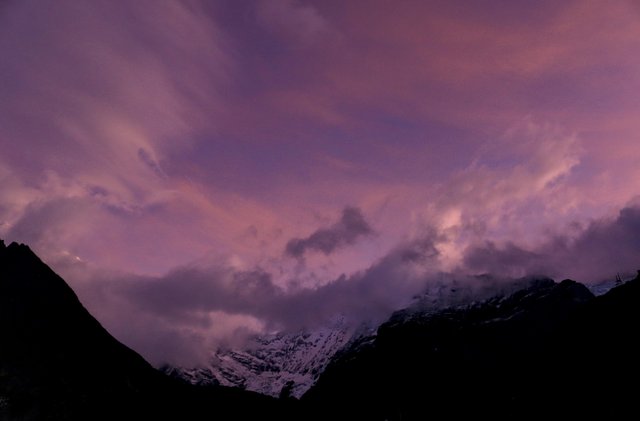
Early morning from our hotel room
There were mountains all around us and we all started jumping and shouting. So i took some early morning photographs and they came out so good and so colorful.
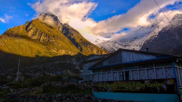
Just outside the hotel
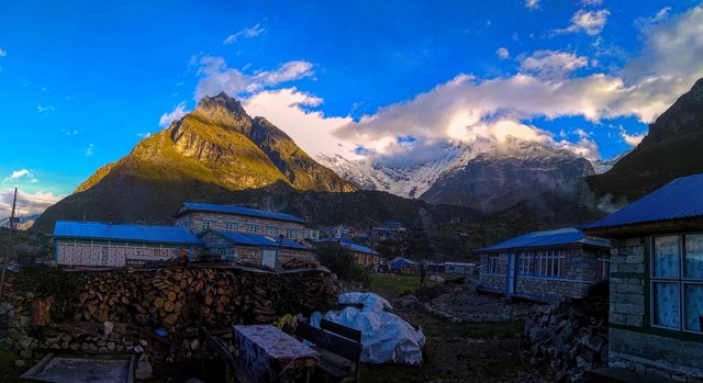
Behind the Hotel
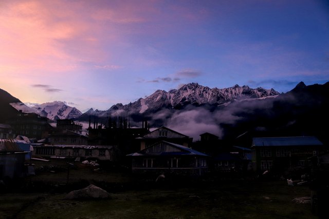
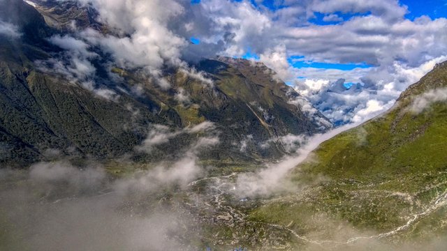
Mountains were starting to show up everywhere and we were greeted by amazing colors
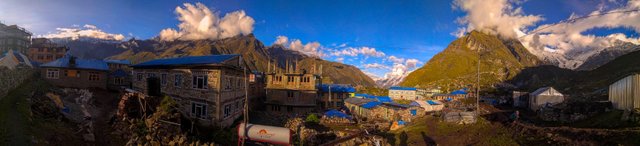
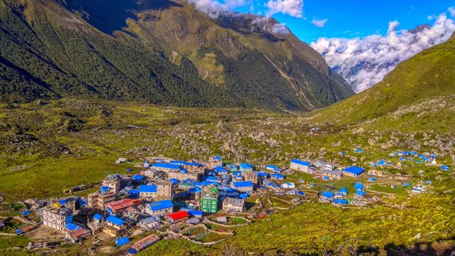
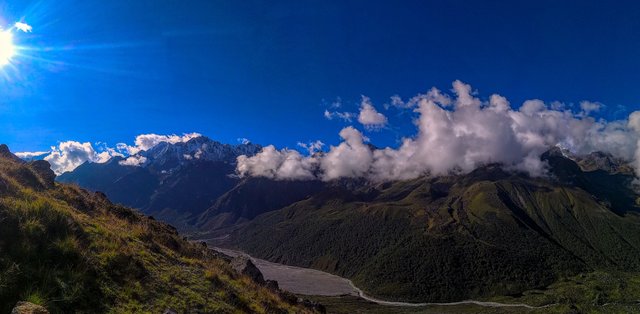
Then it started becoming brighter and i started taking panoramas and what not. The wonderful village of Kyanjing Gompa, which was all dark and gloomy when we arrived the day before, was now the most beautiful village i had ever seen.
The view was even more amazing.
The same view with our hotel in the foreground
Then i decided for a wide angle panorama shoot to show the entire village and the mountains surrounding them and this is how it came out.
Then we started planning for our trek that day and decided that we would reach upto Kyanjing Ri( 4300m) and then end our trek. We asked locals about the route and about time, packed some water bottles and snacks and left for the ascend. And yes, we had our breakfasts too. We were told it would take us about 2hrs for an ascend of 400m i.e. ( 4300m -3900m)
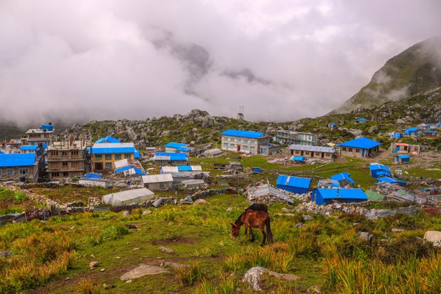
After a small ascend, we got to see the entire village of Kyanjing Gompa and those shiny blue roofs. The village is popular for yak farming and you can get local yak cheese here.
The beautiful village at 3900m was now looking so small.
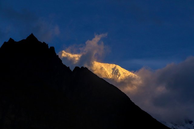
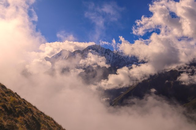
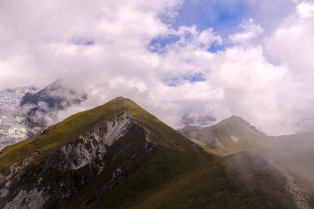
Then we started seeing clouds moving so fast but we were told not to worry because the weather still looked fine. Also, we started seeing clear view of the mountains. Breathing was becoming faster now that we started gaining altitude but the soothing view all around helped us forget that.
Baden Powel Peak
Now it was the steepest part to the top and we started taking breaks every 5 minutes for acclimatization. The village was now very very tiny.
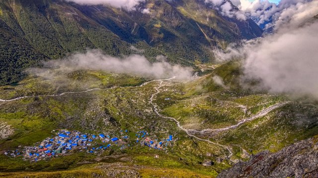
The tiny village from almost the top
Then, within no time, we reached the top and it was a wonderful moment. It took us only about 1.30 hrs to reach the top and it was an achievement for us. It was my third time above 4000m and fourth above 3900m and maybe i was now more habituated to the height than ever.
We started shooting time-lapses and videos. I had my phone setup for time-lapse(Checkout this video for amazing timelapse view)
and i have also a gif ready for you guys below.
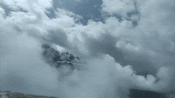
I would recommend GIF to load once and then you see it for smooth intended view
We were now on the lower peak of Kyanjing Ri(4300m) and the higher peak(4773m) was clear but we decided not to go there as we were told the view was similar and the trail was even more risky due to landslides.
Kyanjing Ri Higher Peak(4773m). Also the langtang glacier is visible on top-left
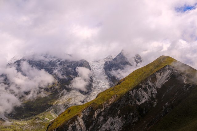
The lantang glacier
When there is sufficient sunlight, the glacier breaks down for an avalanche but we didn't get to see that. Also we could now see one of the sources of river origin and what looked like a lake on the mountain base.
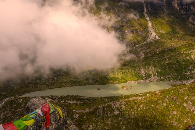
The source of lantang river
Rivers originating from mountains
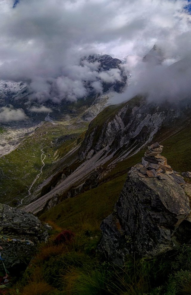
We were already late now and so, we took one last view of the village before we decided for our way down.
One last view
I also took one last panorama shot of the mountains
After about 30 minutes, we descended our entire ascend and we were back to the village at 3900m and it ended up being the most memorable day of our trek.
As always i would like to hear your response. This time i would like to know if you are adventurous or not and would love to hear your similar experiences.
All videos, timelapse and photos created by @cave-man using Canon 200D and Xiaomi Redmi Smartphone
Hi cave-man,
Visit curiesteem.com or join the Curie Discord community to learn more.
Curie is such an awesome project for steem and i always wanted to be a part of its curation.
Keep on inspiring and supporting people like us.
I love the positive vibe that it brings on content creators like us.
@cave-man if it is very beautiful the landscape the photos the video as I would like to live an experience like this I am amazed not to be afraid of climbing little by little until the top the photos say everything great work I congratulate you for the roofs of the Are houses painted blue to identify them?
We have these sheet roofs that mostly come out in blue color and maybe so. Also, blue signifies the sky and is a honourable color in tribals culture as well.
Your should try it then, if you love this experience.
Thank you for the support.
Congratulations! Your high quality-travel content was selected by @travelfeed curator @jpphotography and earned you a reward, in form of a 100% upvote and a resteem. Your work really stands out. Your article now has a chance to get curated and featured under the appropriate daily topic of our Travelfeed blog. Thank you for participating in #travelfeed!
Learn more about our travel project on Steemit by clicking on the banner above and join our community on Discord
I used the travelfeed tag without knowing and its like the best mistake i have made in days. Love to know that there is a great project like this on steem.
Thank you so much for the support.
That's great! We loved your mistake!
I am speechless! Fantastic stuff! Upvoted and resteemed!
Exactly what i wanted to hear. Thank you so much for the support.
Exactly what i
Wanted to hear. Thank you so
Much for the support.
- cave-man
I'm a bot. I detect haiku.
You welcome!
really good!!!!Upvoted and resteemed too ;)
thank you @fotogruppemunich. Glad that you liked it.
Your low light timelapse was inspiring.
Hiya, just swinging by to let you know you're being featured in today's Travel Digest #328. Please drop by to check out all the rest of today's great posts and consider upvoting the Travel Digest if you like what we're doing.
Thank you. It hasn't been long since i learned using steemitworldmap feature and i am glad that i did it.
Surely will check them. Travel Digests are awesome.
Awesome pictures! And what a stunning view!
thank you for the support. Means a lot.
Good wishes @cave-man,
Your post "Above 3900m || Lantang Trek || (Video, Timelapse, Panoramas)" hast just been Resteemed !!! 😉😄😉
Just keep being with me. Cheers..
😄😻😄 Regards, free resteemed bot @tow-heed😻🙃😻
Amazing post, dude! Cool timelapse, great photos! Awesome!
Thanks dude! Glad that you loved it. Thanks so much for support.
Hey @cave-man that is amazing photographs, such adventure is not for everyone, you have to be tough and strong enough both mentally and physically to decided to do that. Therefore these pictures could give us an impression how it is up there and these enormous vast wildness, mountains with its clouds and glacier that many of us never see so close. Despite of sunny days, it looks quite cool and windy, the temperature might be low too. The Kyanjing Ri camp looks nice place, real houses so you have a nice rest. Thank for this adventure,
Cheers from art-supporting blog @art-venture

I totally agree with you. Wonderful that you knew what i was trying to do here. I wanted to show everyone what i saw through my eyes. For those who can do it, it can be a guide or a preview and for those who are unable to, it could mean a lot to be as close to the Himalayas through panoramas, timelapses and a photo illustration of the trek.
What i loved even more was, there were an Australian couple in their 70s and they were so much stronger and determined than we were. They managed to complete the trek so easily and thus inspired the question i asked at the end.
Finally, i thank you for the support and this has inspired me to do more and create wonderful posts.
Cheers.
Congratulations @cave-man! You have completed the following achievement on the Steem blockchain and have been rewarded with new badge(s) :
Click on the badge to view your Board of Honor.
If you no longer want to receive notifications, reply to this comment with the word
STOP