5 Beautiful Satellite Images of our Planet you won’t believe are real #1
In my job at the European Space Agency we look at what satellite applications can do for non-space sectors of society. Sometimes, however, you simply have to stop what you do and enjoy the majestic beauty of some of the images we get!
I have long believed that our space instruments - Earth Observation Satellites or the Hubble Space Telescope - deserve an award for the artistic beauty of their images. Here are 5 of my favourites from recent months together with a short description of what you are seeing.
I hope you will enjoy!
The Musa Bay at the northern end of the Persian Gulf of Iran

In the centre you can see the port city of Bandar Imam Khomeini. The city is situated at the terminus of the Trans-Iranian Railway, a route that links the Persian Gulf with Iran’s capital Tehran. The dark area to the right of the port is Musa Bay, a shallow estuary. The large geometric structures along the top appear to be evaporation ponds for extracting naturally occurring minerals from the ground. The left side of the image is dominated by the marshes and mudflats of the Shadegan wildlife refuge. It is the largest wetland in Iran and plays a significant role in the natural ecology of the area, including the wintering habitat for a wide variety of migratory birds. It is the most important site in the world for a rare species of aquatic bird: the marbled duck. The northern part of the wetland is a vital freshwater habitat for many endangered species and is considered a wetland of international importance. Therefore, satellite images of this landscape are frequently viewed by organisations working with environmental protection.
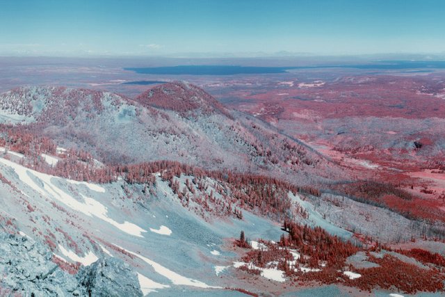
Australia’s Lake MacKay
.jpg)
The lake is located on the border of the states of western Australia and its northern territory at the edge of the Great Sandy Desert, which covers nearly 285 000 sq km. The salt lake sees water only after seasonal rainfall, if at all. It is classified as an ephemeral lake, meaning it exists only after precipitation compared to a seasonal lake, which sees water for longer periods. About half of Australia’s rivers drain inland and often end in ephemeral salt lakes like these. The greens and blues in this image show desert vegetation or algae, soil moisture and minerals (most of which is salt). On some of the brown ‘islands’, and on the shore in the lower right, we can see the east–west sand ridges forming lines in the landscape.
The Rann of Kutch seasonal salt marsh in western India
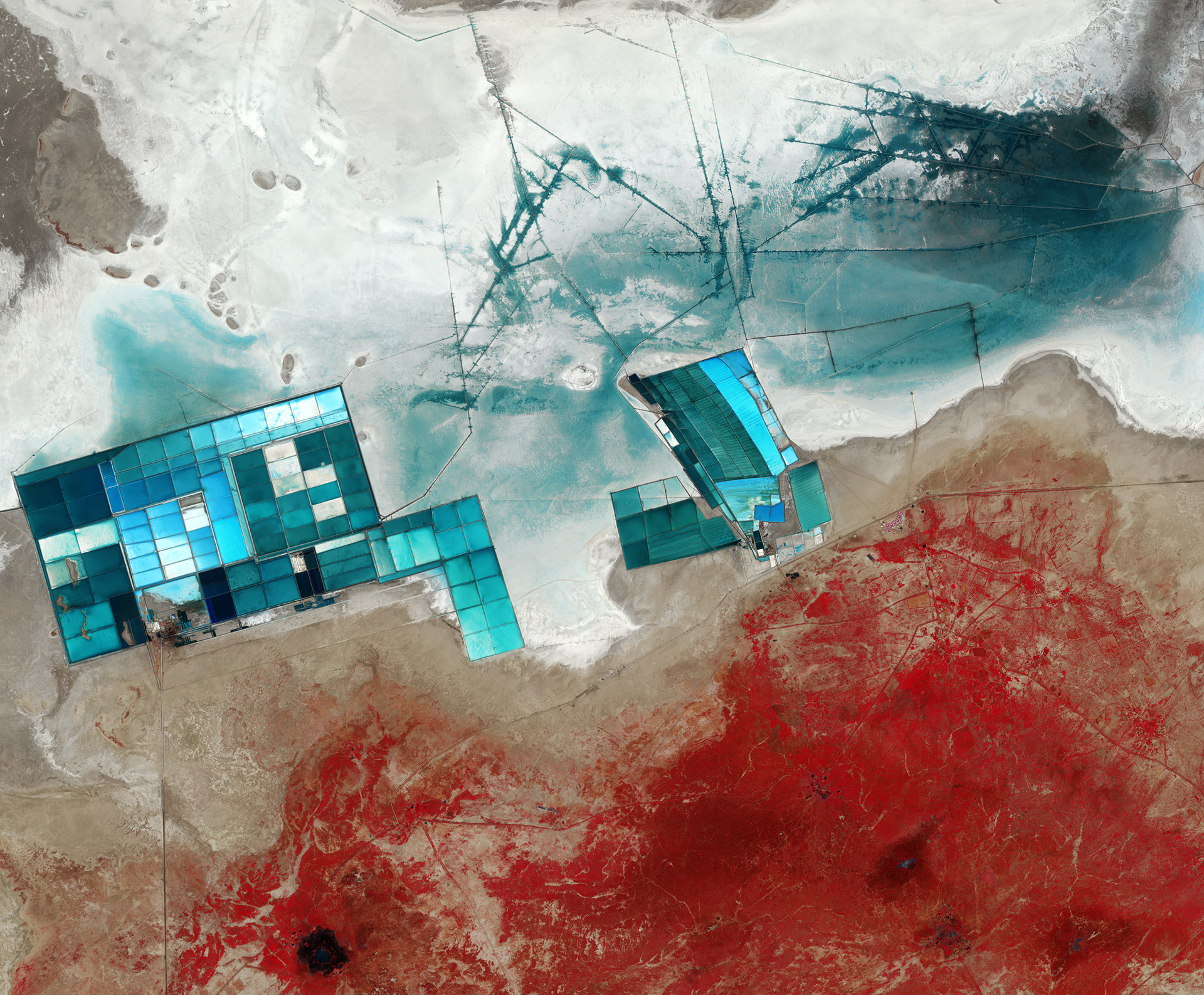
The Rann of Kutch seasonal salt marsh in western India is one of the largest salt deserts in the world. During the summer monsoon season, the area fills with water which then disappears in the drier winter season. The vast white desert is a popular tourist destination, in particular for the Rann Utsav festival. The festival centres around a luxury “tent city”, barely visible central right as a series of semi-circles.
Large salt evaporation ponds dominate this image as blue squares. These ponds are part of one of the major projects here, which is the production of potassium sulphate, commonly used in fertiliser. To give an indication of the size of these ponds, the width of the cluster on the left is nearly 13km! The lines (upper centre) are ditches used to control the flow of the water for the ponds. In this false-colour image, the strength of the blue colour in the pools and surrounding land depend on the mineral content, as well as the depths of the pools. Meanwhile, the red colours seen at the bottom of the image is vegetation (plants absorbs more of the red part of the electromagnetic spectrum to drive photosynthesis, making them appear red in images that include this part of the spectrum). This area is the Banni grasslands, known for its rich biodiversity. Today, Banni’s vegetation is sparse and highly dependent on rainfall, but reoccurring droughts are increasing pressure on the arid region. Other factors, including overgrazing and the invasion of a non-native thorny shrub, are also a stress factor on the environment. Satellite images are often used to monitor this development over time.
The Ötztal Alps of Tyrol in western Austria
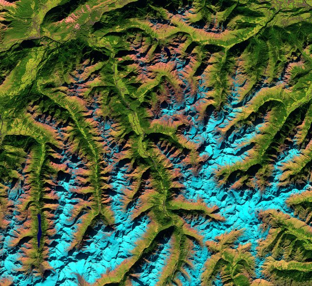
The shadows across the image may play tricks on the eye, resulting in the valleys (the green areas) look higher than the light Blue Mountains. You may want to try rotating the image, or turning your head to the side so the shadows fall in a different direction, to ‘fix’ this optical illusion. The reason why the snow appears in shades of blue because of the “false-colour” filter that has been used using light in the near- and shortwave infrared part of the spectrum. This colouring makes it easier to distinguish between snow and vegetation and to differentiate between clouds and snow (which can be difficult in other parts of the spectrum as they are usually both white).
In the upper left we can see part of the Inn River, flowing east from the Swiss Alps and through Austria and Germany before entering the Danube (not pictured). The land in the Inn river valley and other river valleys appear green with patches of agriculture. The highest peak in the Ötztal range is Wildspitze, standing over 3770 m. The mountain is visible in the lower-left corner, east of the elongated lake, Gepatschspeicher. Satellite images help measure the amount of snow gathered in the mountains, which is highly valuable information for the local hydropower companies and other's interested in projected electricity prices.
The Gobi Desert in Southern Mongolia and northern China
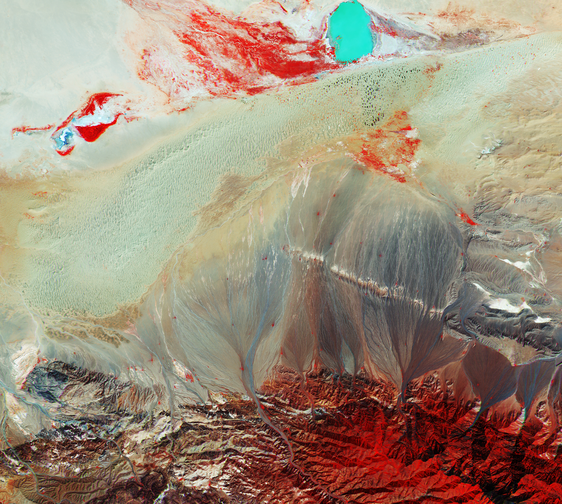
Home to the Gobi desert, Mongolia is predominantly a sandy and rocky plain with an average elevation of 1500 m above sea level. At the bottom you can see part of the Baga Bogd Mountain range with its highest peak reaching 3600m.
There is a very distinct body of water towards the top right part of the image, the Taatsiin Tsagaan Lake, one of the four saline lakes that make up the Valley of the Lakes. The lake’s depth and high concentration of salt give the water a vivid turquoise colour. The lines seen from the mountains reaching down into the desert are made by erosions where the eroded soil, with the help of rain, is carried from the mountain slopes to lower lands. In the warmer month, some low vegetation can be found also in the desert and rocky mountains. These, along with some scattered trees, provide the red colours seen in the southern mountains and close to the waters. Varying tones of red represent the different types of vegetation and densities and condition of the plants.
Want to try it out yourself?
All images above were taken by the European Sentinel 2 A or B satellites. You can download the raw data from these yourself for free here, which can be processed professionally by the free tool snap. Or you may want to find and process images online here!
I hope to share more of these breathtaking images and make it a regular theme for my steemit blog. If there are parts of the world (perhaps where you live) you want to see an image of please let me know and I’ll dig it up!
Thank you for reading this far! My next posts will cover:
- “My interviews with 25 Astronauts, and what it taught me about life, our planet, and much more”
- “The UK to build the world’s first commercial Astronaut training centre – and what it means for the future of space exploration”
- “So I built and launched a Pink rocket at NASA Kennedy Space Center”
- “5 incredible things we can now do with satellites! #1”
So Follow me and stay tuned for more!
This is really cool stuff. I'm going to check out those sites you suggested. UpVoted and Resteemed.
Same.
Thanks a lot @oceancoinz I am happy you liked it!
If there is demand for it I would be very happy to also make a series of how to get started accessing, processing, and then interpreting satellite image data. So hope it can be valuable to those following :)
Also I'm happy to find and prepare images of places on Earth that you guys are curious to see. So please let me know if there is a region, city, or landmark you would love to see :)
Followed and upvoted you back.
Great article! The Danube delta would be nice. :)
Amazing! Upvoted and followed :)
Wow, these are really beautiful satellite photos! I just tried to find some images from the place I live, but that was extremely blurry compared to the ones you found :P
Thanks for the positive feedback @valth !
Where do you live? Perhaps I can dig something up for you and feature it in my next satellite image post :)
Ah nvm I see you are a fellow Norwegian like myself :) what region / city are you from? Being from Stavanger myself I could not help but find one of my region :)
https://steemit.com/flatearth/@lasseehlers/flat-earth-the-best-flat-earth-video-of-2017
So you decided to flag this post because of that?
Nah, he did that because he's a mongoloid cretin.
He is working for a fraudulent company and he is spreading lies about the reality we live in, that is why.
If the Earth is flat, how is that satellites like the one taking these photographs, do not fall ?
Also , if you are so kind, could you explain me how is that different stars can be seen in the North of the planet and in the South of the planet ?
If you convince me with both explanations you will have another follower, and I will reconsider the whole thing.
Let them expose themselves; no need to flag.
Any pictures taken from satellites are In low Earth orbit, within the sealed Earth system. Outer space Is just a fiction created by Freemasons to control humanity.
You do know that even students in the majority of developed countries have sent cubesats into orbit and taken images and done experiments? Are they also in on the massive effort to control humanity? :o
I think it is a bit sad that, in a time where we are doing truly amazing things and opening our eyes to exciting new worlds, that some of you instead insist on closing your eyes and imagine living in a smaller less exciting world.
The Earth Is Flat, It Is a closed system, with other beings entering our world from other dimensions close to ours. The Truth Is far more amazing than the fictional world the Jesuits and NASA have created. There's no curvature, the rotation of the Earth 0f over 1000mph has never been measured once, flight paths match the flat Earth map and the horizon always rises to eye level. When you break the brainwashing you truly are free. We are all Pure Consciousness, we are Infinite.
Agreed.
https://steemit.com/flatearth/@lasseehlers/flat-earth-flat-earth-physics-episode-4-0-the-iss-satellites-and-the-thermosphere
Satellites does not exists.
thanks for sharing ,
i'm iranian :)
Great. I'm working with Sentinel 2A at the moment. I posted recently about it:
https://steemit.com/science/@rmach/food-agriculture-and-satellites-a-glimpse-of-my-new-job
@rmach
will check it out...
That's really cool @rmach ! I will Follow you back and hope to learn more about your work :)
Will be posting more images on this topic going forward as I will be making it one of my themes. Just posted an image for the #colorchallenge here as well. Giving a very rough explanation for why vegetation is red on satellite images, and why that information is useful :)
I would be happy to connect with your further. Feel free to drop me a message on steem.chat with some more info on your work. I would be curious to learn more as this is very much linked to the work that I am doing at the moment!
@fredrikaa
wow...lovely images...you did very well...
Musa bay in persian gulf of Iran is awesome...love the images as well as that of Australian Lake mckay looks like a nice painting with excellent color contrast...are you sure these are just satellite images?
Never heard such exists like Rann of Kutch seasonal salt marsh and knowing its one of the largest salt deserts in the world...can salt be extracted there for real as i thought salt mainly comes from salt waters..?
For The Ötztal Alps of Tyrol in western Austria, it is just awesome....nice work mate...
Now dude, tel me that The Gobi Desert in Southern Mongolia and northern China is a water colored painting that deserves award and not satellite imagery...wow ...more like waterfall that turns red below...
When i read your intro i knew steemit has gotten a valuable asset never knew you will turn out to win
my heart on your first post...you did very well and as such, won my upvote and followership as always...
Keep it up buddy...Steemit is for the likes of you...
Thanks a lot for the kind words!
I am also stunned by the amazing feedback and support I have already received here on steemit, and are eager to continue the journey :)
To answer some of your questions: It is true that these images are not 100% as you would have seen it with the naked eye from an airplane. All of these images are taken by the Sentinel 2 A/B satellites (these are 2 optical remote sensing satellites that are part of the Copernicus program). The Sentinel 2 satellites have 13 spectral channels incorporating four visible and near-infrared bands at 10 m resolution. So they detect far more light than the human eye can see. These images have been processed to include light in the near-infrared. This is done in order to observe and monitor the status of vegetation. (Healthy vegetation absorbs blue and red-light energy to fuel photosynthesis and create chlorophyll. A plant with more chlorophyll will reflect more near-infrared energy than an unhealthy plant). Therefore, when you photograph a forest or an area filled with vegetation with an infrared camera it will have a red colour as seen in the image below which is an image taken on the ground with similar equipment.
This is extremely useful, as it allows us to continuously process and compare new satellite images with old ones using cloud computing. Machine learning algorithms then get better and better at detecting and reporting the small differences that correspond to deforestation, forest fires, plant diseases, etc. All done autonomously of every square meter of the Earth.
Anyways, I guess some may be disappointed to hear that this is not exactly how these places would look to the human eye. However, to me, that just makes these images even more fascinating. Because it demonstrate how much richer in beauty the world actually is and give us a deeper insight than our innate senses are capable of providing on their own. Thus expanding our idea of what is possible and hopefully giving our creativity a whole new set of ideas to work with.
I see I should definitely make an own post explaining this in more detail, both for educational purposes and simply to clarify questions people may have about the images I share. So thank you for inspirng me to write a new post :) Again thanks for the very kind words! I look forward to continue making these posts!
you a great and knowledgeable steemian....good work and the images are great and good as art and photography which i know taging those areas will attract a lot of steemians...
i will keep monitoring and enjoying your posts
keep up the good work mate
thanks
Those are some really amazing photographs, looking through a satellite is just amazing as looking under a microscope!! can't wait to see your new post~
And thank you for using the #sciencepic tag too, more science pictures are always welcome!!
indeed! Satellites give us Superman-like abilities! Being able to fly around the world at ~27 000 km/h, seeing the entire world from above, and having x-ray vision through radar instruments and sensors that cover wider parts of the electromagnetic spectrum!
They may not carry a red cape, but they have a lot in common ;)