RE: 5 Beautiful Satellite Images of our Planet you won’t believe are real #1
wow...lovely images...you did very well...
Musa bay in persian gulf of Iran is awesome...love the images as well as that of Australian Lake mckay looks like a nice painting with excellent color contrast...are you sure these are just satellite images?
Never heard such exists like Rann of Kutch seasonal salt marsh and knowing its one of the largest salt deserts in the world...can salt be extracted there for real as i thought salt mainly comes from salt waters..?
For The Ötztal Alps of Tyrol in western Austria, it is just awesome....nice work mate...
Now dude, tel me that The Gobi Desert in Southern Mongolia and northern China is a water colored painting that deserves award and not satellite imagery...wow ...more like waterfall that turns red below...
When i read your intro i knew steemit has gotten a valuable asset never knew you will turn out to win
my heart on your first post...you did very well and as such, won my upvote and followership as always...
Keep it up buddy...Steemit is for the likes of you...
Thanks a lot for the kind words!
I am also stunned by the amazing feedback and support I have already received here on steemit, and are eager to continue the journey :)
To answer some of your questions: It is true that these images are not 100% as you would have seen it with the naked eye from an airplane. All of these images are taken by the Sentinel 2 A/B satellites (these are 2 optical remote sensing satellites that are part of the Copernicus program). The Sentinel 2 satellites have 13 spectral channels incorporating four visible and near-infrared bands at 10 m resolution. So they detect far more light than the human eye can see. These images have been processed to include light in the near-infrared. This is done in order to observe and monitor the status of vegetation. (Healthy vegetation absorbs blue and red-light energy to fuel photosynthesis and create chlorophyll. A plant with more chlorophyll will reflect more near-infrared energy than an unhealthy plant). Therefore, when you photograph a forest or an area filled with vegetation with an infrared camera it will have a red colour as seen in the image below which is an image taken on the ground with similar equipment.
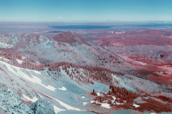
This is extremely useful, as it allows us to continuously process and compare new satellite images with old ones using cloud computing. Machine learning algorithms then get better and better at detecting and reporting the small differences that correspond to deforestation, forest fires, plant diseases, etc. All done autonomously of every square meter of the Earth.
Anyways, I guess some may be disappointed to hear that this is not exactly how these places would look to the human eye. However, to me, that just makes these images even more fascinating. Because it demonstrate how much richer in beauty the world actually is and give us a deeper insight than our innate senses are capable of providing on their own. Thus expanding our idea of what is possible and hopefully giving our creativity a whole new set of ideas to work with.
I see I should definitely make an own post explaining this in more detail, both for educational purposes and simply to clarify questions people may have about the images I share. So thank you for inspirng me to write a new post :) Again thanks for the very kind words! I look forward to continue making these posts!
you a great and knowledgeable steemian....good work and the images are great and good as art and photography which i know taging those areas will attract a lot of steemians...
i will keep monitoring and enjoying your posts
keep up the good work mate
thanks