Canadian Rockies: Wells Gray Provincial Park, the waterfall wonder.
Hey Steemies!
Most of our time in British-Columbia was snow, snow, snow ...Every night. On this morning, there was even more, a few inches at least, everything was completely covered. Everything had turned into a blank canvas overnight. The sun reflecting in every snowflake like someone had thrown a bag full of Christmas glitter all over the ground and trees, what a way to wake up! We weren't too sure what to do on this day. We mainly went there for Mount Robson and Kinney lake and we never really planed anything else past that. One track mind , I know. We both knew climbing to Kinney Lake would be the highlight of our trip and anything we did after would be hard to top and surely disappoint, not that it wouldn't be great just our minds were still in a dream state from the last journey.
After a quick google map search by the fireplace, we found our destination for the day, the land of 39 named waterfalls, Wells Gray Provincial Park near Clearwater B-C. Nestled in the east central part of the province in the Cariboo Mountain region, the park protects various species of wildlife, birds and landscape in it's 5250 square Kilometer boundaries, being the fourth largest park in the province. Named after the Honourable Arthur Wellsley Gray, Minister of Lands for British Columbia from 1933 to 1941, the park was established in 1939 and has seen additional surrounding land added to it's boundaries over the years. For this reason, the park is oddly shaped and there are private properties and stables that line the road that connect the added sections to the park. I wonder if they feel like they live in a Provincial Park. Great place for stables anyhow! Mr Gray was know for his admiration for nature and exploration of the landscape and went on to establish other large provincial parks across British- Columbia recognizing the need for these zones to remain sanctuaries during his time in politics until his Chief Forester, Ernest Manning met his untimely death in a plane crash.
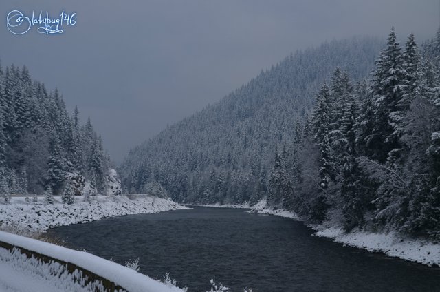
Fraser River. Shot 1/250 sec. f/8 46 mm, ISO 125
This place wasn't that close to where we were but just a couple of hours drive away, naturally we hit the road nice and early to take advantage of the limited daylight available. Everything was foggy and it looked so gloomy but for some reason today, I was really enjoying it. All the sparkling trees just kept going up the side of the mountain to gradually disappear into the thick clouds above, it made everything look like a scene from a Christmas card. For parts of the drive it looked all too familiar since we had been here a few days prior exploring but then we both knew when we entered new territory. The road conditions were really bad to be honest, the snow had made the narrow winding road really slippery and given that some areas were sharp turns at elevation overlooking the valleys. Beautiful but nerve racking. As we continued along, we kept seeing cars abandoned in the ditch and tipped semis every few kilometers. Clean up crews all over pulling vehicles out, some near the above mentioned creepy curves. Luckily we knew what we could encounter and had studded tires and 4 wheel drive truck that loves the mountains as much as we do, good chance we would be just fine but still a dreadful reminder to be vigilant and quickly established which direction to aim for if we start to slip. 😬
Shot 1/160 sec. f/5.6 18 mm, ISO 200
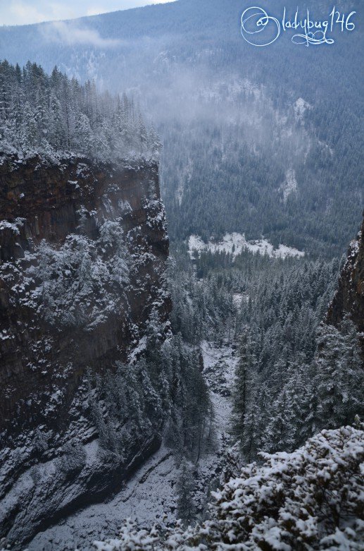
We finally made to our destination safe and sound, the sun looked like it was trying to come out but no miracles, solid effort tho but not quite, the clouds were too thick. I made peace with the fact that it was going to be mediocre lighting for photography, I wasn't as disappointed as I thought I would be given the poor lighting, I quickly realized this was turning into a scouting mission for future trips. We still knew absolutely nothing about this place aside from it had 39 waterfalls. As far as photogenic, well, probably not today but we made our first stop to look at maps, trail guides and features of the park posted at the rest stop and pick a more specific destination. We generally come a little better prepared than this with actual physical trail guides to take with us because much of these remote places have no internet or phone signal. This time of year, all the tourist information centers, attractions and campgrounds are closed until summer and only the roads thru the park and trails are open but this was a completely spontaneous visit, all we had was the signage in the park. Our main intention was volume, hit up as much as we can that is easily accessed from the road or short hiking distance until sundown, at 39 waterfalls, shouldn't be too hard to accomplish, we only have 4 hours of daylight left anyway, I can't wait until summer's endless days come back... The struggle in the North is real😒
.jpg)
Shot 1/250 sec. f/4 18 mm, ISO 100
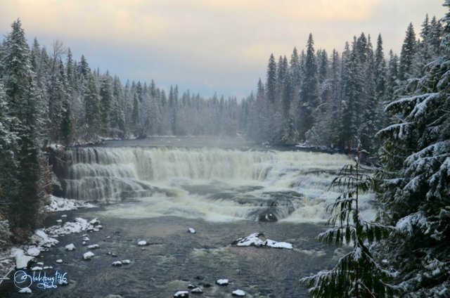
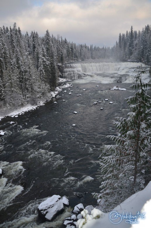
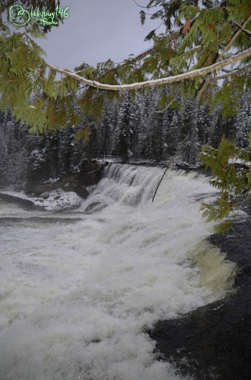
Our first scenic stop was at Spahat Creek Falls, a popular stop for tourists because of the proximity of the Yellowhead trail (The highway). Spahat is the Local First Nation word for Bear. It once was a small provincial park of it's own but was added into the Wells Gray Provincial Park boundaries in 1996. The area is known for it's black bear population roaming thru the park, they have bear watching areas set up thru-out Wells Gray. The waterfall is pretty near the parking lot, once on the trail we actually found ourselves above the waterfall but we didn't know it yet because it comes out of a cave below our feet. The trail continues around the edge of a cliff (all fenced in and safe enough for families) to get a front view of the 60 m (197 ft) tall waterfall from a wooden balcony. It took about 15-20 minutes to get a good view and a few pictures and we were back in the parking lot, it's a pretty easy stop.
Video taken by @silvergingerman with iphone 8
The terrain gets it's features from ancient volcanoes that erupted and left behind hardened lava pools that can still be seen today and a network of underground caves and rivers for water to flow. The last ice age covered the area with glaciers, as they melted over the years and continue to recede, they reveal and carve the ancient volcanic landscape leaving behind a large network of waterfalls in a small area. This park is still fairly unknown to the majority of the population and new geological features continue to get discovered to the present day. The terrain is fairly rugged but a popular attraction for many hikers and backpackers. Now that we came, we saw, we left lol. We got a better view of a maps and topography in the park instead of the wooden arrows on the side of the road we were going by earlier. One thing Alberta has over BC, all the trails and features are clearly identified in Alberta, in BC, we kind of have to guess or ask locals for the views. We found two potential locations that had easy to access waterfalls to view in close proximity to each other but it was across to the other section of the park and an additional 35 km away but they seemed worthy but time was passing fast and we began a race against time.
One the road again meant that I had plenty of time to analyse the new surroundings and form an opinion of this place. I saw many trails that lead to other waterfall or features, some trails travel along the ridge of the canyon, making me wish we had time to do one of them. Then came the confusing part, the park is not really one large section of land, the road took us thru the valley filled with ranches and stables nestled in the fields surrounding the mountains until re-entering the park at a further location. Once we passed the little village, everything became deserted. It was now mid afternoon and we were now the first set of tracks in last night's snowfall. Surely this place is buzzing in the summer but it's now a ghost-town, hopefully the road wont be to bad from here on out. Our Next target was Dawson Falls also known as "Devil's punch bowl".
Shot 1/250 sec. f/5 18 mm, ISO 100
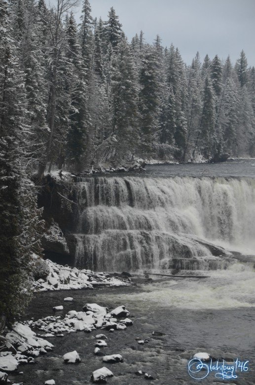
The Murtle River drapes over a 5 meter plateau created by volcanic flow over 200,000 ago, the stone is so durable that the flow has been unable to carve thru and the flow hasn't seen significant changes or patterns and the sand beneath remains untouched. Like any other waterfall in the area, it gets it's flow from melting glaciers as it disperses around the watershed. We encountered a drop-off area and ignored it but there really wasn't anywhere to park s we went strait to the parking lot a few minutes down the road. The view above could be seen strait from the parking lot, it's a freebie folks!! We still wanted to get closer to the waterfall and view from a different angle that turned out where that other drop off led to for future reference. No biggie, we gladly took the walk making a fresh trail, it was obvious nobody had been here in a while and how far could it be? For a while it appeared to be taking us away from the waterfall then after reaching the drop off, the trail continues toward the fall again. Longer walk than anticipated as it seems to detour but still fairly short and easy. The flow was certainly more violent than it initially appeared once we were standing next to it, it may only be 5 meters drop but it's still pretty impressive.
Shot 1/250 sec. f/5 18 mm, ISO 100
Shot 1/320 sec. f/5.3 78 mm, ISO 400
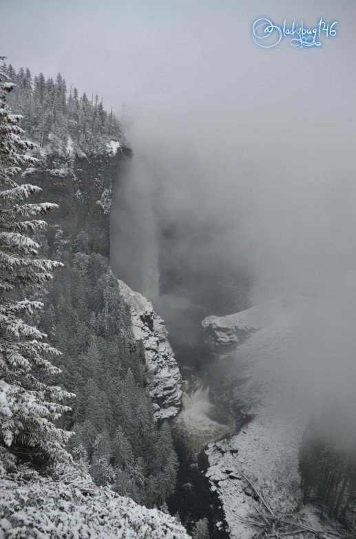
As nice as it was, it wasn't the grand finally or the waterfall I had in mind, it was just on the way. One the sign I looked at when we were at Spahat Falls, I saw something about the 4 th largest waterfall in Canada that grabbed my attention, Helmcken Falls. We wasted a lot of time walking closer to Dawson fall and we could see the daylight disappearing by the minute, we really had to get a move on. Our final destination was only a few kilometers away, and we probably had time but it would be close. We hurried but unfortunately it felt a little shy and was hiding behind the fog it was producing. With the sun going down, the sudden drop of temperature sure didn't help. I suppose the land can't reveal all it's secrets on the first visit and would give me a reason to come back.
Shot 1/125 sec. f/5.6 18 mm, ISO 320
Because we can hardly see it doesn't mean we can't talk about it a little. Still on the Murtle river, this 141 meter (463 ft) stands as the 4th tallest waterfall known in Canada. Although it may be hiding right now, there is a trail on the ridge facing the waterfall for a better view. Mr. Gray's Idea of protecting this piece of land revolved around preserving this waterfall and the surrounding water basins and continued to gain territory as the years go by and new discoveries are made. The sun is going down and we don't have time to do it today but it's only one hour hike for anyone interested, it was the trail that stood out the most to me and got me excited. Keep in mind that the flow of the waterfalls I have shown you today is at it's minimal flow due to the glaciers freezing back up for winter. In the summer you can expect some violent action happening and if anything like Athabasca falls, would be a sight to behold.
Shot 1/250 sec. f/4 18 mm, ISO 160
This was only 3 waterfalls out of 39 , I think I have a few more left to discover so I have to return. Next time, we will have to take a week and come camp here directly in the park and explore as many trails and climb as many mountains and find as many lakes as we can in that time. Since then, glacial melts have revealed a new cave in a rugged remote part of the park, potentially the largest ever found in Canada with an entrance of about 100 meters long, and 60 meters deep. It is currently closed to the public until proper permits are in place to research and local indigenous communities consulted as to the future outcome of the find. Until then the location will remain remain undisclosed. Get more info:
To conclude, if you are expecting to get catered to like the resort type experience filled with gift shops and trinkets and an easy vacation, this is definitely not the place for you but if you are into the back country and having the forest to yourself while exploring, this is hiker's paradise and is filled with natural treasures to be discovered. I certainly can't wait to learn more about this area and walk these canyon ridges and climb the various unnamed peaks until my legs don't want to move anymore! If you like Kananaskis Country like @snowyknight, you will surely fall in love with this place too, it is a very similar experience to be had. So many things have yet to be documented about this park, maybe I can contribute one post at a time with my photography, never know, some species and features have been found by regular people publicly logging their hikes and much is yet to be revealed by the rugged landscape and melting glaciers.
Here is more info on Wells Gray Provincial Park:
https://www.wellsgray.ca/site/activities/waterfalls.html
All images were taken with Nikon D7000 and Sigma 18-200mm lens
Cheers my friends! X🐞X
Waterfalls! Even better waterfalls surrounded by snow and ice! 😍
Thanks for lighting my day with the stunning scenery again. 39 waterfalls here for real? How many days will it take to see them all?
Frozen waterfalls are the greatest! I'm glad you enjoyed it. for real, 39 named waterfalls, meaning there is probably more either to small to name or not found yet. There are a bunch of mountains and other area that are not named yet I'm not sure how long it would take to see all 39, several days for sure, I will try my best to do it myself. The issue is much of the features can only be accessed by foot so it would take quite some time to get around the rugged terrain.
Congratulations, Your Post Has Been Added To The Steemit Worldmap!
Author link: http://steemitworldmap.com?author=ladybug146
Post link: http://steemitworldmap.com?post=canadian-rockies-wells-gray-provincial-park-the-waterfall-wonder
Want to have your post on the map too?
This is terrific! Wonderful post, I've resteemed it for the world to see.
Posted using Partiko Android
Awwe Thank you for sharing my work, means a lot. Merry Christmas!
That.. is a lot of snow! The struggle is real ;) I love to read your stories, but I have to tell you that I like the photo's better when there's color in the trees and such :D
haha yeah I hear you, I like an abundance of color but I don't always get what I want!! Winter is so dull.
Congratulations @ladybug146! You have completed the following achievement on the Steem blockchain and have been rewarded with new badge(s) :
Click here to view your Board of Honor
If you no longer want to receive notifications, reply to this comment with the word
STOPWOW what amazing scenery even in the dreary winter conditions, I to am looking forward tot he longer days of summer Winte only. Officially starts tomorrow but I have had enough of it already LOL
I know I was a little disappointed when I made that realization and we have had snow here since last August... it's beginning to feel like the forever winter out here, I had enough too. Good news the days will be getting longer everyday from here on out! YAY
Thank you for your continued support of SteemSilverGold
Congratulations! Your high-quality travel content was selected by @travelfeed curator @guchtere and earned you a reward, in form of a 100% upvote and a resteem. Your work really stands out! Your article now has a chance to get featured under the appropriate daily topic on our TravelFeed blog.
Thank you for being part of the TravelFeed community!
Learn more about our travel project on Steemit by clicking on the banner above and join our community on Discord
Thank you @travelfeed!
Hiya, just swinging by to let you know you're being featured in our daily Travel Digest. If you enjoy steemit worldmap and the manual curation effort we're going through each day, please consider supporting what we do!
Thank you @steemitworldmap!
Dear @ladybug146,
Thank you for the submission for our project – 1001 Places to Remember. Hooray, your story is now listed in our project publication, you can check through our progressive report either from our @fundition project page or @archisteem account. We will be sorting out the seasonal shortlist authors and make an announcement soon for the seasonal reward.
Stay tuned and Steem on!
@archisteem and team
Thank you @archisteem!
You are most welcome @ladybug146!