Canadian Rockies: Change of plans, Kananaskis day 3
Hey Steemians!
Much like the night before, the temperature dropped even lower, as cold as it was I still fell asleep right away and slept like a log. It was refreshing after a sleepless night from the night before and little did I know I would really need it for the day to come! I suppose the fact that it's cooler here, we get to sleep in a few hours longer than usual before we start roasting in the tent like a turkey on thanksgiving. It was looking like a promising day, the sun was shining once again, the clouds had finally cleared after a starless night, today we would finally get to hit the trails.
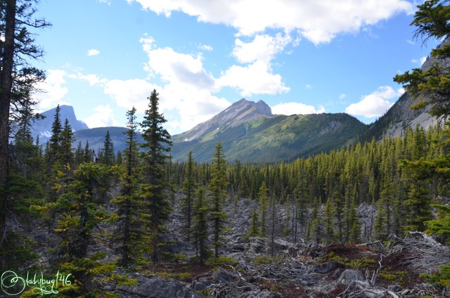
We decided we would visit the famous Rawson Lake still located in Peter Lougheed Provincial Park, when we looked on the internet(before we left) and in our trail guide, this place looked exquisite and we were both pretty excited to get there. We got to the parking area near Upper Kananaskis Lake, packed up the backpack with the usual... you know... water, snacks, trail guide,camera gear, bear spray...the essentials we would need until sundown. We get on the trail and very soon after, we came across a sign, I thought, oh no...trail closure. As I suspected, the area we wanted to visit was closed due to frequent grizzly activity in the recent days. As much as @silvergingerman was stubborn enough to want to keep going, I exercised my vito power and said well I kinda don't want to get mauled by a grizzly(s) in the middle of the forested nowhere with no cell phone reception. I get we are in bear country and we might run into one by accident but I'm pretty sure I don't want to go where I know there are several hanging around, besides seemed like we had the place to ourselves, we had hardly seen anyone so far.
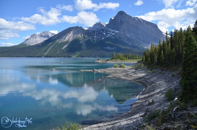
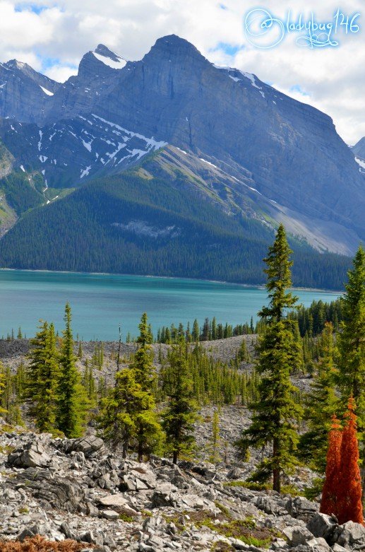
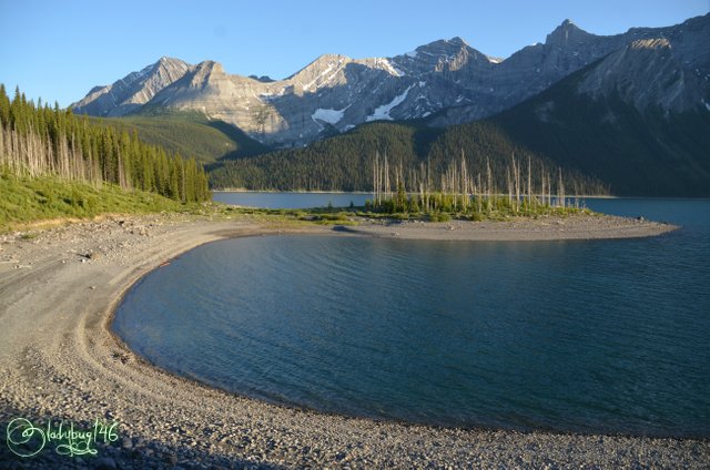
Upper Kananaskis Lake. Shot 1/250 sec. f/8 18 mm, ISO 100
Since @silvergingerman was more disappointed than I was, I let him pick the trail, for some reason he had to make it to Hidden Lake, some 4 km round trip. We still didn't eat so a short hike then come back have a bbq, sounds good... I like it. To get to the trail, we headed to the North Interlakes parking lot(Same parking lot as the Mount Indefatiguable hike or near the Upper Lake hydro-dam). To do this hike, you should dress in layers even if it seems warm because of the change in terrain also has a significant change in temperature, a hat is very helpful to prevent you from baking in the sun and minimizing heat stress related illnesses.
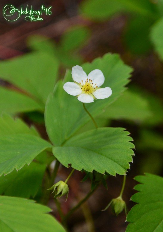
Field strawberry vine and flower.
Shot 1/1000 sec. f/6.3 200 mm, ISO 800
Shot 1/640 sec. f/6.3 200 mm, ISO 800
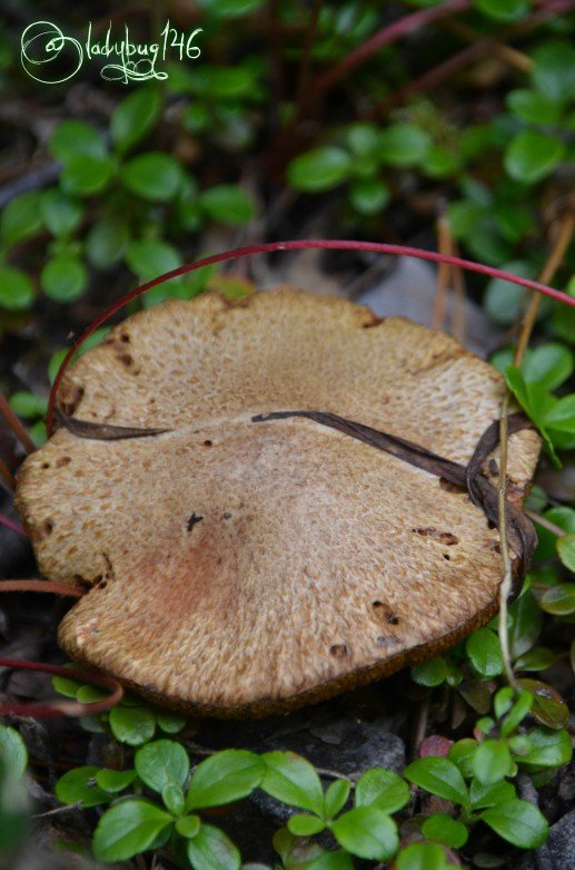
The beginning of the trail was really cold from the giant lake's breeze but as we got into the woods, it started to warm up. For the most part, we were shielded from the sun with the tall trees, we were slowly gaining height at a manageable level as we were going around Upper Kananaskis Lake and Mount Indefatiguable , suitable for families or the less ambitious hiker. The path was lined with various wildflowers, mushrooms and wild strawberry vines. It reminded me of growing up on a mountain in the Appalachians, our back yard was filled with these tiny red bursts of flavor. Naturally the berries attract the smaller wildlife like chipmunks who are very friendly by the way. Don't be surprised if one comes climbing all over you checking you for food or follow you around for part of the journey. (Reminder, it is unlawful to feed or harass animals in a National or Provincial park in Canada)
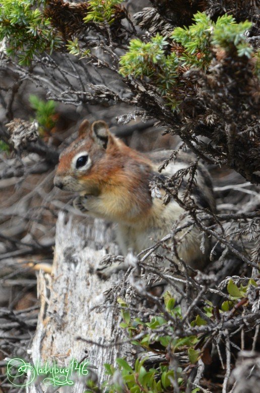
Rocky Mountain Chipmunk.
Shot 1/800 sec. f/6.3 200 mm, ISO 800
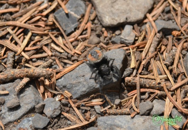
Gross spider I just had to take a picture of because I'm weird like that... eww lol.
Shot 1/1000 sec. f/6.3 200 mm, ISO 400
The fist kilometer or so of the hike is mainly in the forest with very little view of the Upper Lake but as we slowly gained altitude, the trees were getting fewer and far between allowing us a peak thru. The official trails are clearly marked and mapped just for the record, it's hard to get lost as long as you remain on the main trail system but having a back-country trail handbook of the area in your backpack as a reference is also very useful as it offers pictures of the terrain to expect and topography maps along with other useful information as there is many unofficial trails that branch of to different features, some longer of a hike than other's in case a wrong turn gets taken.
.jpg)
Taken by @silvergingerman with iphone8
Shot 1/800 sec. f/6.3 200 mm, ISO 800
From this point on, a choice had to be made, a junction in the trail, both leading to the same destination. The lower trail, an easy going trail that would take us thru the bottom of the next geological feature I will talk about without gaining much elevation or the upper trail, a more arduous rocky trail taking us halfway up Mount Indefatiguable's crumbling debris field with the most spectacular view. Of course we picked the harder one! As an Amateur photographer, I always pick the view and not much can deter me from it. The closer we got to the debris left behind by long term erosion, the more we were loosing the shielding from the trees and it was starting to get pretty warm...like baking in a clay pot warm. The slowly crumbling face of the mountain as left behind a pile of crumbling rocks, much like the near-by Glacier Rock I spoke about in a previous post. For the most part, it appeared to be somewhat calm and stable since resilient vegetation somehow grows thru the rocky field, I wouldn't be surprised if we were standing directly in an avalanche area if something were to trigger it.
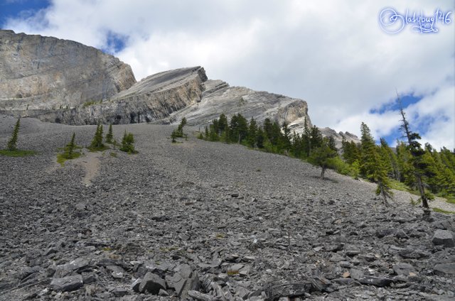
The view from the trail looking up at Mount Undefatigable (about half way up the mountain).
Shot 1/320 sec. f/9 18 mm, ISO 100
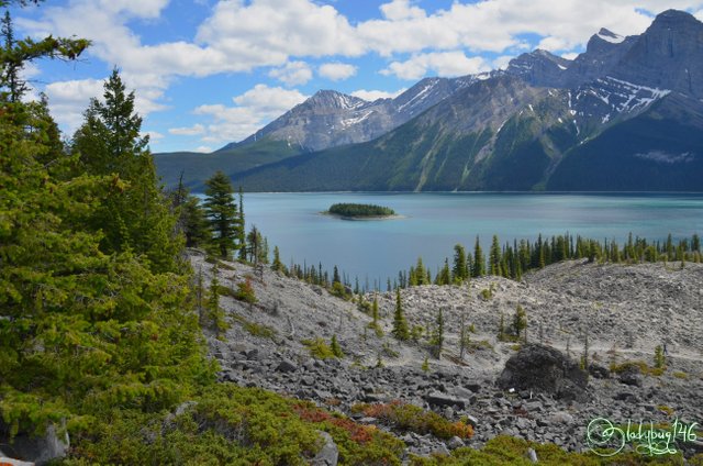
View looking down towards Upper Kananaskis Lake from the same location.
Shot 1/250 sec. f/8 18 mm, ISO 100
Shot 1/250 sec. f/8 18 mm, ISO 140
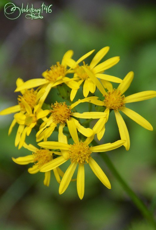
The one message I seem to never find the words for in my posts, is the size of the landscape, it's hard to imagine how giant everything around us actually is and pictures never really cut it. Just to give you perspective, that faint line you may see thru the rocks, that's part of our trail down thru the rubble to get access to Hidden Lake. From this point, we are about half way to our target location. The views were worth the extra work we put in, such an extreme change in terrain we didn't quite see coming. Thru the ruble, not only trees but even wildflowers growing proud in their less than ideal conditions. Here is a few species below, I didn't have time to research each individual species yet.
.jpg)
Shot 1/1000 sec. f/6.3 200 mm, ISO 640
.jpg)
Shot 1/1250 sec. f/6.3 200 mm, ISO 400
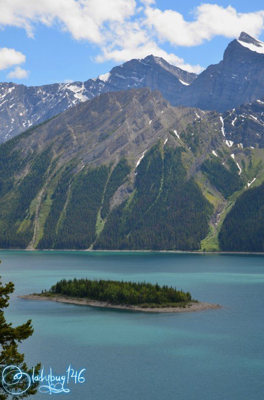
The terrain looked more intimidating than it was, aside from the scorching heat it was easy enough to navigate thru as long as we stayed on the path. The trail continued to follow the edge of Upper lake, revealing it's true beauty from a vantage point as we made our way. Each twist and turn in the trail significantly altered our view. As time went by, we started to encounter a few more people, it was almost reassuring. After the rocky section, we were back into the shade of the subalpine forest until the next checkpoint, the secluded camping area.
Soon after the campground, we found Hidden lake, honestly, it should have stayed hidden. I suspect it's a more impressive view in the spring when everything melts but by now it was pretty much dried up. More like an aqua colored puddle. I knew this was it, @silvergingerman was in denial, he refused to believe we were at his chosen destination. I figured why fight with his stubbornness, lets keep going. I knew in my mind we were about a quarter way around Upper Lake and we should have enough time to get out by sundown. I'm cool with walking 20 km until we reach the other side of the lake(mind you we took a bit of a detour earlier included in the 20 km)...lets find out what my other half is made of and how long until he accepts reality!! hehe
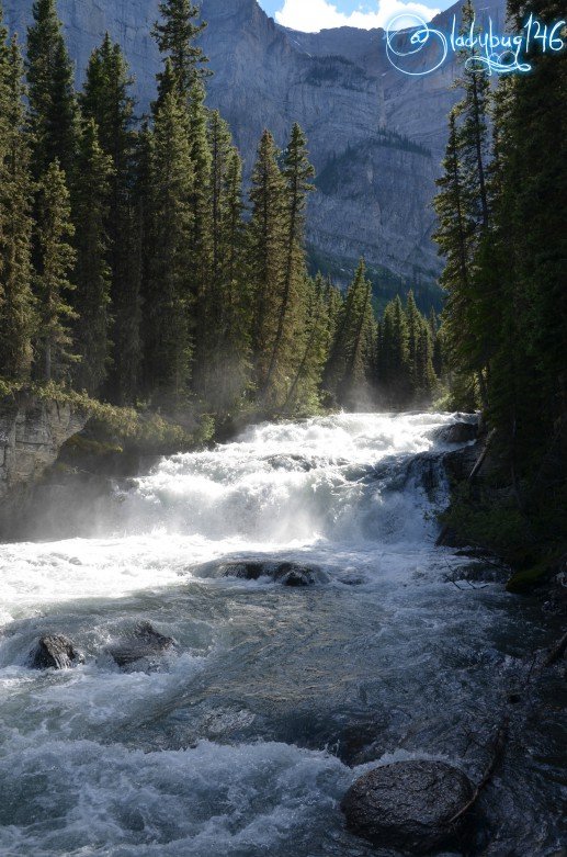
Soon after we passed the Hidden Lake area, we heard running water in the distance, we knew we had to look for a waterfall or something. A small side trail took us down to the Kananaskis river where it turns into a cascade before the main trail gets across the bridge.If you are taking this hike for photography purpose and don't want to walk more than the 5 km return trip on fairly easy ground this is a perfect hike for you, started in early afternoon, you should hit spectacular lighting over the lake's most photogenic angles for most of the afternoon. The view up until this point is magnificent offering different terrain and landscape I highly recommend this to anyone looking to refresh their eyes at least until reaching the river. If you decide to keep going like we did, be advised it's a long walk from here on out.
Shot 1/250 sec. f/8 22 mm, ISO 110
After several hours of walking and still not seeing his Hidden Lake, @silvergingerman finally came to terms with the fact that I was probably right all this time. By this point we had walked almost 10 km already it wasn't too hard to convince him to keep going now. The rest of the trail is a slight up and down thru the subalpine forest until reaching the Upper Lake Parking lot. During our walk, we encountered several cascades and a waterfall. An easier access to the Lower Falls would be a short walk from the Upper Parking lot towards Rawson Lake in opposite direction from our current route) For the most part, the landscape remains the same and not overly difficult or exhausting until the upper parking lot aside from the fact that it's a 20 km walk. A mix of pine trees and wildflowers fill the air with a delightful fragrance for most of the way.
Shot 1/1250 sec. f/6.3 200 mm, ISO 400
Shot 1/500 sec. f/6.3 200 mm, ISO 200
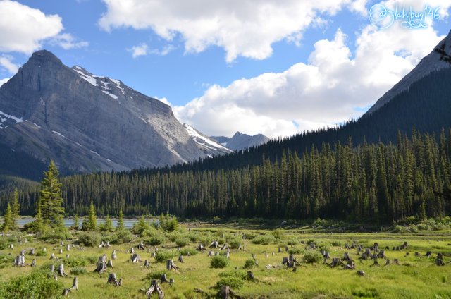
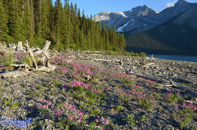
I know I just mentioned parking lot, but it's not ours, we still had another 4 ish km left to do, almost like a sign a false hope, we were getting tired and anticipating FOOD. On the last leg of our hike, much of it was along the cliffs of the lake where a narrow path carved thru the mountain over a 20ft drop overlooking the rocky shores. One more note worthy spot with a fantastic view, right before we reached the hydro-dam area, the beach had a bunch of dead tree stumps likely fallen during the spring melts all washed ashore across the lake, it looks like a graveyard of tree stumps covered in flowers. It was the most peaceful scene we needed after such a long walk, knowing we were near the end and we still had one hour of daylight left, we stopped and took a rest. The end seemed so far away still even if we could see the parking lot.
Shot 1/200 sec. f/8 18 mm, ISO 200
Shot 1/250 sec. f/8 22 mm, ISO 200
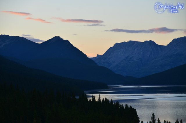
Without the detours to points of interest, the Upper Lake Trail is 16.2 km all the way around, we walked 20km total on the day with our side attractions... 4 km round trip he said. 😅 Happy we had finally made it, we pulled the cooler and the BBQ out of the box of the truck and had ourselves a burger feast overlooking the sunset on Lower Kananaskis Lake. My belly was happy at last! What a day, I rate the full Upper Kananaskis Lake trail for moderate level of fitness because of the length of the trail and the slight up and down thru most of it adds up. That is all I have for part 3 of 5, check back in a few days for the next hike. If you have missed part 1&2, I will post a link at the bottom of the post. Thank you for reading!
Shot 1/250 sec. f/5.6 95 mm, ISO 500
Cheers! X🐞X
All images taken With Nikon D7000 and Sigma 18-200 lens unless otherwise stated.
https://steemit.com/travel/@ladybug146/canadian-rockies-first-steps-into-kananaskis-country-day-1
https://steemit.com/travel/@ladybug146/canadian-rockies-moody-mountains-in-kananaskis-day-2
I was astonished when I saw your first photo of Upper Kananaskis Lake. It is a marvelous photo of a marvelous place.
Your articles make me feel as if I were there. Thank you.
That photo is my favorite from the whole trip!! Thanks for stopping by :)
Gorgeous! I would avoid the bears as well. They are always impressive to see, but it’s soooo much better when day there is a car door between you and a bear. 😄
The spider was gross. How big was it?
I really like the picture of rhe rapids/ waterfall type area. Bet the cool air created from the water felt amazing after all that walking.
Totally agree with the bear thing, I would like to see one but only if i'm sheltered! The spider was about the size of my index fingernail. Big for up here, but not that big at all compared to other spiders elsewhere!
It felt so good and refreshing, where you see the log vertically leaning, we could get right about there and get sprayed by the waterfall or whatever that is (it was only like 4 feet tall)
Hiya, just swinging by to let you know you're being featured in our daily Travel Digest. Please drop by to check out all the rest of today's great posts and consider upvoting the Travel Digest if you like what we're doing.
Thank you!
How come every Canadian lake I see has such blue water ;D Amazing.
It has to do with the minerals brought down from melting glaciers to the bottom and super clear water. When sunlight hits it it reflects the blue green colors from the sediment. You need good sunlight to see it and the camera still catches nothing compared to the real life colors. The blue lakes are really cool, one of my favorite features of the Rockies.
Thanks for this extensive reply! Had no idea =)
Wow, the nature photographs are truly fantastic. The picture of the bird as well, keep up the good work!
Thank you! the bird is not a bird, it's a bee.
Beautiful photos. I especially love the rocky landscapes. Great capturing.
thank you for stopping by and viewing!
World of Photography
>Visit the website<
You have earned 6.50 XP for sharing your photo!
Daily photos: 1/2
Daily comments: 0/5
Multiplier: 1.30
Block time: 2018-07-27T10:06:03
Total XP: 210.24/400.00
Total Photos: 30
Total comments: 7
Total contest wins: 1
Follow: @photocontests
Join the Discord channel: click!
Play and win SBD: @fairlotto
Daily Steem Statistics: @dailysteemreport
Learn how to program Steem-Python applications: @steempytutorials
Developed and sponsored by: @juliank
Thank you for your continued support of SteemSilverGold
Congratulations @ladybug146! You have completed the following achievement on Steemit and have been rewarded with new badge(s) :
Click on the badge to view your Board of Honor.
If you no longer want to receive notifications, reply to this comment with the word
STOPTo support your work, I also upvoted your post!
Congratulations, Your Post Has Been Added To The Steemit Worldmap!
Author link: http://steemitworldmap.com?author=ladybug146
Post link: http://steemitworldmap.com?post=canadian-rockies-change-of-plans-kananaskis-day-3
Want to have your post on the map too?