Canadian Rockies: Aboard the Ice Explorer at the Columbia Icefields and surrounding glaciers +900 ft Skywalk
Hi Steemians!
Rain or shine, today was going to be the most exiting day ever, being on our agenda for years now but one of those things we never got around to do because we travel to Jasper National Park on the off season and this attraction is closed from October to May due to poor weather conditions in such elevations. This was the whole reason we picked Jasper as our destination instead of the original plan of Mount Robson...Ah well delayed one more year I guess, slowing chopping away at our Rockies bucket list(it gets longer every visit to be honest😧). It is possible to visit the area anytime and we did several times but you can't get on the actual glacier on your own for safety reasons. I advise booking almost a week ahead of time to get on the Ice Explorer because it's an extremely popular attraction and spots are limited, it can fill up really fast. Perpetual winterland better be ready for this hot duo, HERE WE COME!!! 😍🙃😎🚩
Shot 1/640 sec. f/6.3 300 mm, ISO 200
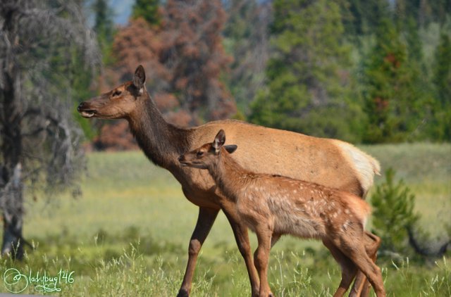
Since we are staying near the boundaries of Hinton, we still had to drive thru the entire park of Jasper and get on the beautiful Icefield Parkway to get there. We didn't plan on seeing much wildlife today because most of the animals inhabit the Montane Forest Region of Jasper where their favorite plants and shrubs thrive but before we left the area for the barren Alpine region for the day, we were greeted by none other than my spirit animal for one last good luck charm for the road, a female Elk and her little Bambi 💕. We encountered this handsome duo last night too but it didn't take long for the road to become completely blocked by tourists surrounding and crowding the pair, as soon as we could get thru the road, we vacated as quickly as we could to escape the madness and not to cause further distress to the already stressed animals left with no escape route. We thought we had missed our chance to get some one on one photo session time with Mom and Bambi, it must have been written in the stars. I have seen many Elks in my day (probably every trip) but never with a young that still has the white spots.
1/250 sec. f/8 26 mm, ISO 160
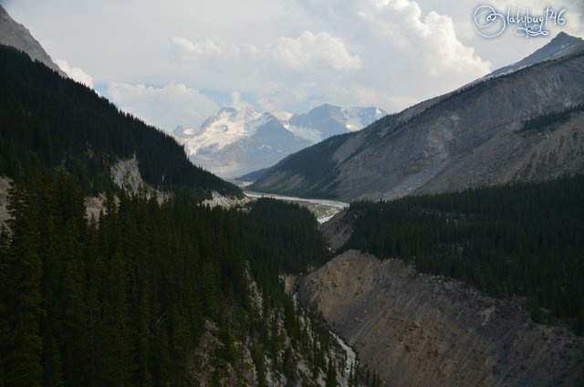
The rest of the scenic drive was pretty uneventful for the most part, the closer we got, the more scarce vegetation gets and frankly, not much wildlife can live here due to the lack of food. Vegetation in the Alpine Region experience a 90 day growth cycle per year and the soil offers poor nutrition in this rocky landscape. To put it in perspective for you, the tiny tenacious trees you may be able to see here an there are actually around 400 years old and measure no more than 4 to 5 feet in height. Many of them suffer from flagging, a natural phenomenon caused by the chilling wind that makes the pine needles to grow on one side of the tree only and the other half looking like nothing more than bare branches. Now that we were here, the excitement was really building up, we still had almost an hour to spare before our departure. We left early enough to make sure we wouldn't miss our explorer ride.
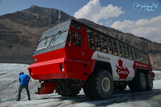
The bus above is what will be taking us to the Ice Explorer, much closer to the glacier.
First, what is an Ice Explorer or Snow Coach? Well I know the name is self explanatory!! Essentially it's a big specialized bus with huge tires that has extra grip to transport passengers and researchers on ice and glaciers, essential for steep areas of the ice sheet. Columbia Icefields has some of the most sophisticated and rare version called Terra Buses, capable of carrying up to 56 passengers and weighing a maximum of 33 tons. Only 24 are in existence in the world, Brewster touring company at Columbia Icefields owns 22 of them, the other 2 are located in Antarctica for research. When I say this is a unique experience, it really is! Now you can see why it is such a sought after journey. Speaking of the name Brewster, If you remember my last post Colonel Fred Brewster is the pioneer behind much of the Rockies tourism infrastructure we have today. Look at this beast!
1/250 sec. f/8 18 mm, ISO 100
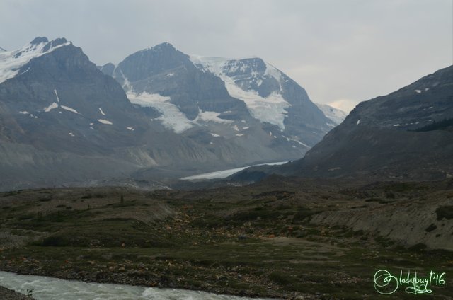
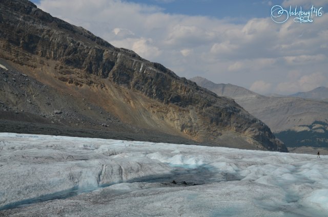
This area has multiple glaciers, Columbia Icefields being the dominant (hence the area named after it). I will point out all the visible ones as I go along. Formed during the great glaciation period (238,000-126,000 bc) covers over 300 square kilometers of ice terrain and can reach a dept of up to 440 meters in it's deepest glaciers that scientist were able to measure. Scientist suspects that it is much deeper in certain areas but were unable to get accurate readings pass this point. It is the largest non polar sheet of ice in the world. About 100 years ago, the ice sheet used to go all the way to the discovery center but has lost substantial mass with warming climates. We are coming out of a mini ice-age therefore it is normal for the glaciers to recede but in the recent years, it has been receding at a faster pace that normal indicating that our climate is changing faster than it should be.
.jpg)
Photo taken by @silvergingerman with iphone8.
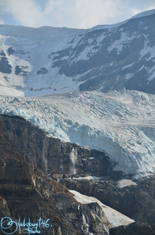
The glacier I am Standing on is the Athabasca glacier, the 3 steps or shelf behind me is the Columbia Icefields. The stream of glacial melt behind me is some of the freshest, coldest water to be found and it is drinkable (wait for it😁). This stream is where my drinking water in Edmonton begins it's journey to my kitchen tap along with much of western Canada feeding three provinces(Saskatchewan, Alberta and British-Columbia) and North-Western United States( I'm standing on my future drinking water...mmm... feet haha!!) This giant ice block is also part of rare phenomenon called Hydrological Apex or Triple Divide meaning it feeds 3 separate oceans( Arctic, Pacific and Atlantic oceans) the only other comparable phenomenon of this scale in non-polar regions is located in Siberia. This feature is mostly associated with Dome Glacier that we will not see today because we didn't have time to do the hike(I will include an older post at the bottom of this post that features photos from the hike where Dome Glacier can be seen).
.jpg)
Taken by @silvergingerman with iphone8.
There it is!! Filling up my bottles of the crisp water. I know I say I like to take off my shoes and put my feet in every crisp clear water from the mountains but trust me this one is way too cold (and I don't want to drink feet water strait up...lol). I lost feelings into my hands filling up 2 bottles of this stuff it was so cold. I assure you this chemical free water is some of the purest, shielded from most pollution being in a such a remote hard to access area and too cold to support/spread bacterial life. Strait from the source as it melts, would you dare try it? Hard to believe it is in the middle of summer from up here. The Icefields area receives approximately 7 meters of snowfall per year and due to elevation, although rare, it is possible to get snowfall in summer as well.
.jpg)
Photo taken by our Explorer driver with @silvergingerman's ipone8.
Shot 1/800 sec. f/7.1 78 mm, ISO 200
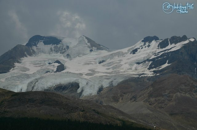
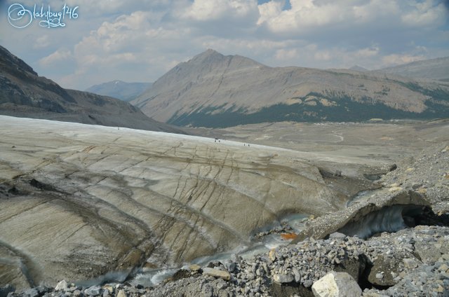
The glacier you can see behind us is called the A-A glacier. It is named this way because it sits on two mountains with A as the first letter of their name, Mount Athabasca and Mount Andromeda. Funny Enough, we were the only 2 Canadians aboard this trip and we quickly realized we had become the tourist attraction ourselves proudly parading our national colors and cowboy hats. We are not new to this feeling tho, we generally are some of the rare Canadians that still dare to venture into tourist land, I think part of it, locals take these geological features for granted because of the proximity, I used to be like this when I lived in New-Brunswick. Back on topic, we generally stand out like a sore thumb and many like to come have a chat with us to find out more information about the geology or where to find other great spots to visit. We don't mind being a walking tourist information center everywhere we go, we very much enjoy our chats with the friendly foreigners and we like to know how far they have traveled to see our prized landscape and what they think of it. Who knows maybe someday someone will leave me a comment that they had a @ladybug146 encounter of the third kind! 😛. We also take a lot of family pictures for visitors, I wonder if I ever get famous if they will know they had their picture taken by @ladybug146! Good thing 99% of my thoughts remain in my head, it gets weird in there sometimes...Hehe!
Shot 1/320 sec. f/9 18 mm, ISO 100
Shot 1/250 sec. f/8 18 mm, ISO 100
Shot 1/320 sec. f/9 18 mm, ISO 100
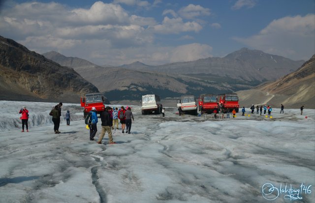
The blue puddle you see above, it is the reason it is unsafe to venture onto the glaciers on your own. Dirt particles that get exposed as the glacier melts create warm spots and it causes the glacier to melt faster in certain areas than usual forming tunnels that drain into or under the glacier and sometimes fissures can get covered in a light layer of snow and make them indistinguishable. Funny story on the tunnels, once, 2 guys went to explore on their own, one turned around and noticed his friend disappeared, he called out for him ad didn't hear back. He took the long journey down to the discovery center to get the rescue team and upon reaching the toe of the glacier (bottom) and found his friend sitting in the puddle all wet, he had stepped into one of these holes and went on the hellish cold wet slide down under the glacier all the way to the bottom. lol this could have ended badly!! Some people have taken the adventure on their own and have died or got severely injured falling into these holes and crevasses. Always go with a guide as they survey the area regularly and know where these hazards are located.
Shot 1/250 sec. f/8 18 mm, ISO 110
*Shot 1/250 sec. f/8 18 mm, ISO 100
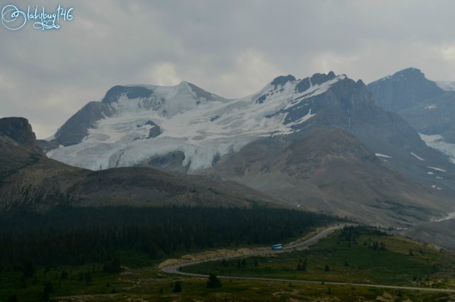
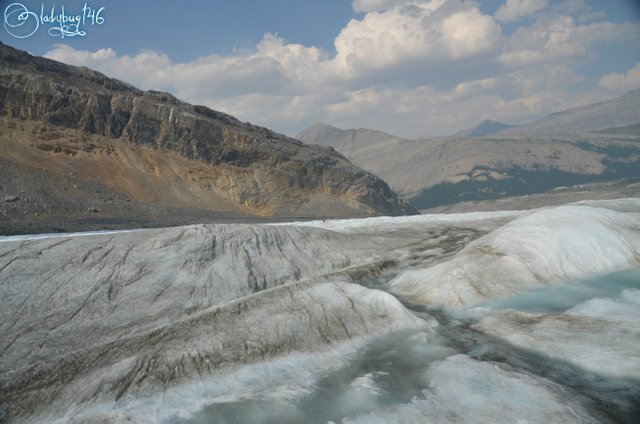
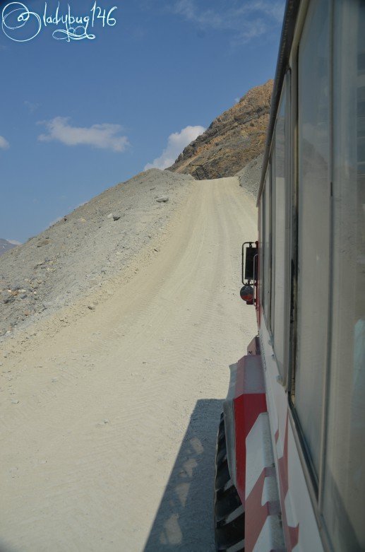
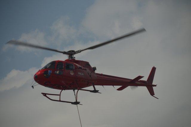
The picture above, is the hill we had to go down to get to the glacier and get back up to return to the discovery center. This is the steepest road accessed by vehicle in the Rockies, it's hard to see it's steep angle from a picture. The fine white powder you see around, that is the mineral that gives all the pretty blue lakes their amazing colors. On the way in, we got fortunate enough to witness the rescue team doing a lift by helicopter (not to worry it wasn't a rescue mission, they were transporting material to fix a damaged bridge on the mountain). I apologize for the quality of the chopper lift, I had to take it thru the bus window because we were not allowed out until it was finished but the moment was neat enough to share as it is a rare sight.
.jpg)
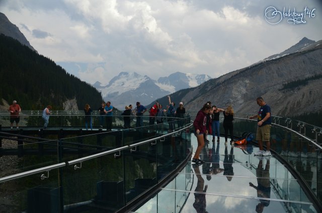
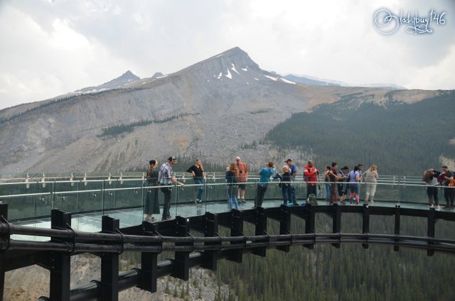
After the Ice Explorer, part of the adventure included with admission is a trip to the Skywalk, about 10 minutes down the road. What is the Skywalk? It is a bridge with a steel frame made of glass sitting over the Sunwapata Valley's 900 foot drop. We passed by this little gem many times but it isn't possible to stop from the road due to lack of space for parking, the only way to access this without doing the glacier tour, is to buy a ticket from the discovery center and a tour bus will take you and you can spend as little or as much time as you wish. Buses run to and from every 15 minutes during the summer season. If you plan on doing both tours, make sure to dress in layers, it is cold on the glacier and warm sumer temperatures on the skywalk.
.jpg)
.jpg)
Both pictures taken by @silvergingerman with iphone8.
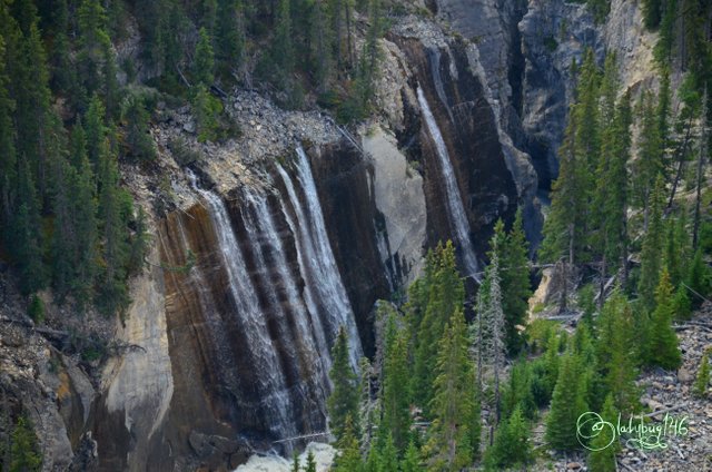
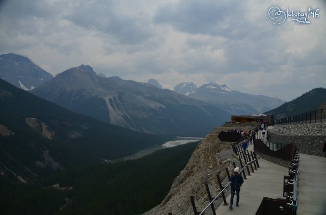
I know many who wouldn't dare walk on this!! Would you?? It's not that scary to be honest but I do spend a good deal of time in the mountains. The sky walk doesn't take long to view, It's a short walk with interactive stations that explain the geology of the landscape and the type of animals that can be seen along with other related information. During peak hours, attendants have little display stations with fossils found in the area and their history. It compliments the Rockies experience really well. From the platform, waterfalls in the valley below can be seen. It takes about half hour to get a good view of the area, no need to plan a whole lot of time for this to enjoy it fully.
Shot 1/200 sec. f/5.6 95 mm, ISO 800
Shot 1/250 sec. f/8 18 mm, ISO 200
Shot 1/160 sec. f/6.3 18 mm, ISO 200
Shot 1/250 sec. f/8 18 mm, ISO 200
Shot 1/250 sec. f/8 18 mm, ISO 200
As you can see, it may be short but the view is absolutely spectacular and well worth the entry cost for both attractions and I highly recommend to anyone passing thru to take part in these two attractions. It fills up most of the afternoon so make that an event for the day. There is several other sight seeing along the way as well like Sunwapta falls and Athabasca falls, I will cover those two in a later post. After this, we did go to Sunwapta falls, I will move it to a different post because this one is getting pretty long as it is and the other two are connected to the same network just down the road from each other closer to the town of Jasper. Alright, that is it for now! Check back later. 😉
All Images were taken with Nikon D7000 and 18-200mm Sigma lens and Nikkor 300mm for wildlife unless otherwise stated.
https://steemit.com/photography/@ladybug146/columbia-icefield-canadian-rockies
Cheers! X🐞X
Another wonderful article! What was the temperature at the glacier?
On the glacier it was around 5-8 degrees Celsius, everywhere else was 20-25 Celsius, Significant change at these elevations and the perma-ice radiates a lot of cold. Thanks for stopping by ! 😘
Hiya, just swinging by to let you know you're being featured in today's Travel Digest #312. Please drop by to check out all the rest of today's great posts and consider upvoting the Travel Digest if you like what we're doing.
awwe Thank you for your interest and promotion, it is always much appreciated 💗
Yeah, with cowboy boots, hats and in a monstertruck to the moon. This post has it all!
Wild wild west baby!! lol I know, the rest of the Canada sees Albertans as a bunch of rednecks haha. I think this post highlights why. We love it...work hard and play harder.
I LOVE the Columbia Icefield! I went there for the first time with my parents when I was 10ish and was lucky to go back many times with my bus loads of tourists. The skywalk must be relatively new? Of course I haven’t been back to the area since 2000! So new could be almost 20 years old! 😄
You two look great with your flag 🇨🇦 ☺️
Yes the skywalk is fairly new so you wouldn't have seen it in your touring days. I'm not sure of the age because it just appeared one day! maybe less than 5 years for sure, they are working really hard at developing new trails to it's different features to enhance the tourist experience, there will be a bunch of new stuff in the next few years too, we saw a whole lot of side construction this summer. I drive by the Icefields many times and do the short hike thru the moraine but this was the first time I was on the actual glacier, it was pretty cool.
I'm amazed every time you post. The pictures you get from your camera are amazing! Hopefully you keep posting our vacations so I'll always be able to look back at them!
I don't plan on stopping my vacay posts!! Don't worry! They help me remember the little details and a good way for me to keep track of the changing landscape over the years. Who knows with so many rare species of plants and animals, I might be capturing things that could go extinct one day or new species no one knew about. Many things have been discovered years later by people keeping a log and photographs.
Hey @ladybug146, this looks extremely familiar. No that I see your photos I kind of regret not going on the actual glacier itself. The colors look amazing when your so close. I bet is was really crowded, but did it feel like that when you were on the glacier as well?
Posted using Partiko Android
Well maybe you will get another opportunity one day, it is a pretty interesting tour and a different feeling being on the ice compared to just viewing from a distance. The ice is extremely blue, even the camera couldn't capture the intensity. The skywalk felt more crowded because it's a much smaller surface. The glacier was pretty busy too but it didn't seem as bad because there is a much bigger surface to roam around. They do a good job at surveying it and marking the hazards and crevasses on an area as wide as they can safely do so to avoid everyone all stuck in a small location.
Fantastic. I just love glaciers. Always so majestic and a bit mysterious. There is so much information and history about our planet trapped in there. Oh, and btw that bus is just mental!
Glaciers are awesome! There is tons of information stored in that ice about the different stages our planet has gone thru in the past. I'm not sure if they ever did ice core samplings there. I would be interested in the results! There has been scientist working there daily. I wanted to go to the discovery center museum to get more info but it was closed for renovations or maintenance. Next time I drive by I will try again. That monster bus is pretty cool indeed! I want one lol...I'll have to wait till steem goes to the moon tho, while everyone is shopping for their Lambos I ill be looking at monster buses haha.
Thanks for the detailed reply! Interesting information :) Hopefully it’s open next time!
Made a lot of great posts. The picture is so great Thank you
Thank you for taking the time to view my story !
Howdy partner, I'm @photocurator, a curation bot; I keep an eye on the photo feeds, I vote random photos of my followers and at the end of the day I publish a post with links to the best photos. Follow @photocurator to get your photos curated in the future!
Congratulations, Your Post Has Been Added To The Steemit Worldmap!
Author link: http://steemitworldmap.com?author=ladybug146
Post link: http://steemitworldmap.com?post=canadian-rockies-aboard-the-ice-explorer-at-the-columbia-icefields-and-surrounding-glaciers-900-ft-skywalk
Want to have your post on the map too?