Geology of Iceland - Part 8: Skaftáreldar | Skaftár Fires
Introduction
The Skraftár Fires describe an event that lasted from June, 1783 to February, 1784. It was the largest and one of the most devastating basaltic fissure eruptions in human history. The eruption took place at the Laki fissures and is therefore also known as the Laki eruption or the Laki Fires. In Iceland this eruption has always been known as the Skaftáreldar, which translates as the Skaftár Fires, because the lava followed down the Skaftá river gorge. The lava flow itself is known as Skaftárhraun or Skaftáreldarhraun (hraun = lava).
The Laki fissures are located in an upland area in south-central Iceland. The southern boundary of these uplands is a huge scarp, a steep cliff that has once been the sea front. The upland area is an ice-free region between the two glaciers Vatnajökull, to the East, and Myrdalsjökull, to the West. The water table in this area is high and it has been suggested that the area was boggy prior to the eruption. The highlands are immediately bordered by the gorges of the glacial rivers Skaftá and Hverfisfljót, which are now largely filled by the Laki lava flow. These two rivers formed a huge outwash (sandur) plane during the Holocene south of the scarp. Most of this sandur plane is nowadays overlain by postglacial lava flows. During the time of the eruption the flatlands that were affected by the eruption have been settled and the area is known as Fire Districts.
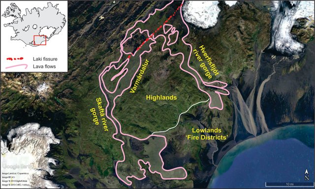
Google Earth image with highlighted Laki fissures and correlated lava flows.
The Laki Fissures
Volcanism is Iceland occurs in volcanic systems, that are comprised of elongated fissure swarms that commonly pass through a central volcano. The Laki fissures lie within the Grímsvötn volcanic system. The system extends from the western margins of the highlands towards the Grímsvötn central volcano. This describes an area that is about 100 km long and 15 km wide. The exact extend is unknown, as the majority of its eastern part is covered by Vatnajökull.
Magmas that erupted in postglacial times from the Grímsvötn volcanic system are tholeiitic and have produced about 50 km3 of lava. 22 km3. 22 km3 have erupted onto the ice-free regions and 15 km3 can be attributed to the 1783 Laki eruption, which represents the only eruption of the fissure system that has taken place since Iceland has been settled. The most active part of the system is the Grímsvötn central volcano. It has erupted at least 36 times since the first settlers stepped onto the shores on Iceland.
The surface expression of the Laki fissures are a 27 km long NE-trending row of at least 140 cones and craters. In the middle, Laki Mountain divides the swarm into a southwest and a northeast row. The cones and craters are arranged along 10 individual, stacked, fissures, which are each between 1.6 and 5.1 km long. The individual fissures are connected by rows of craters. The height of the individual cones varies, but can reach up to 120 m. Cone size gradually increases towards the center of the each fissure, where the majority of lava outpour occurred. Here they usually form scoria cones. Spatter cones are generally smaller (10-40 m), but represent the most common cone type and are usually confined to the end of fissures.
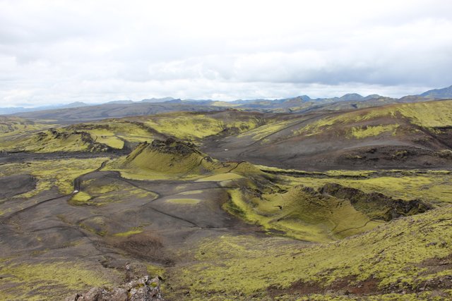
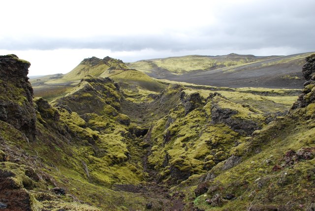
Top: Cones along the Laki fissure. Photo by Zinneke, commons.wikimedia.org. Bottom: View along the central Laki fissure. Photo by Chmee2, commons.wikimedia.org
.jpg)
Effusive volcanism
Seismic activity occurred 3-4 weeks prior to the eruptive outbreak. Earthquakes were so strong between May 29th and June 8th that people living nearby Laki, slept outside in tents. The first fissure opened at 9 a.m. on June 8th 1783 and the last active fissure was reported on Febuary 7th 1784. Most of the lava flow can be accounted for by ten separate lava surges, corresponding to ten main flow units produced during the first five months of activity.
The first lava flows emerged from the SW-row of the Laki fissure. In the next 48 days, 60% of the total eruption volume (9 km3) was erupted by five lava surges between June 8th and July 25th. Each surge was 1-2.5 km2 big and flowed over 35 km away from its source in less than 4 days. The lava flowed over the western part of the highlands in two main lobes. The first stayed confined to the Skaftá river gorge and the second one flowed along the Varmárdalur and Hellisá river valleys. When the lava reached the end of the Skaftá river gorge, it fanned out over the cultivated lowlands.
In the 90 days between July 29th and October 29th, another 5 km3 eruptions shifted to the NE-row of the fissure swarm. Here, another five lava surges, each between 0.5 and 2.0 km3 in size, advanced 25-35 km within a week. The lava moved northwards and southwards. The southward moving lava advanced down the Hverfisfljót river gorge for 25 km before reaching the low lands. Lava moving northwards from the fissure filled the outwash plain of the Skaftá river in front of Vatnajökull. The first three lava surges were each separated by a period of 2-3 days, whereas the intervals between surges three to six were 2 weeks each, increasing to 2-4 weeks between surges seven to ten.
The remaining 7% of the total eruption volume erupted during the last 3 months of the event in smaller outbursts. In total, all lava flows cover an area of 599 km2 and comprise a volume of 15 km3
Lava types vary but generally, lava flows start as pahoehoe flows that grade down flow into slab pahoehoe and aa-like flows, which end in concentric ridges, orientated perpendicular to the flow direction. The ridges are the result of new lava flows being injected into earlier lava flows, thus pushing the old material into ridges. Within the pahoehoe lavas, rootles cone complexes represent a common feature. They are genetically related to the emplacement mechanism of the lava itself.
Effusion rates and fountaining
General effusion rates for the Laki eruption average around 6000 m3/sec. They were highest at the beginning of each of the ten main eruption episodes and gradually dropped. At their peaks they produces spectacular fire fountains. Several reports from Icelandic settlers’ state sightings of lava fountains form different locations. In the early stages of the eruption, fountains had to exceed 1350 m to be seen from central South Iceland, and more than 800 m to be seen from the Fire Districts. These numbers are reassured by calculations using the effusion rate of individual eruptions. Total peak column height was 12,000 m. These correspond with reports, stating that some eruption fountains could be seen from all over Iceland.
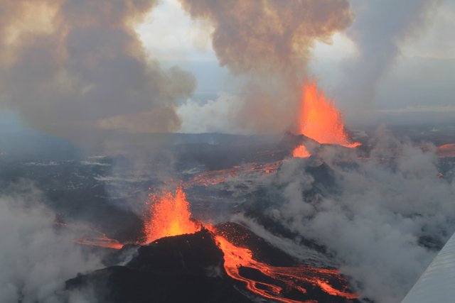
Lava fountains from the Bárðarbunga Volcano, September 2014.
Photo by Peter Hartree, flickr.com.
The Laki – Grímsvötn connection
It is proposed that the Laki erution was part of a major volcano-tectnic episode on the Grímsvötn volcanic system. The Grímsvötn central volcano had been active multiple times during the Laki eruptions. This led to the assumptions that the two eruptive systems are connected. Early studies proposed, that
Injection of magma from a reservoir located under the Grímsvötn volcanic system at the crust-mantle boundary appears to be the best explanation of magma supply at Laki, and lateral drainage of magma from a high level Grímsvötn chamber to the Laki fissure may not have been an important mechanism in the 1783 eruption.
Explosive Volcanism
Two types of pyroclastic deposits have been identified at Laki. These are_ Strombolian_) and phreatomagmatic (hydromagmatic). Lava-water interactions can be observed in areas where the flow contacted running water or advanced over water-saturated ground.
During explosive eruption, tephra got hurled into the air and deposited to various distances.
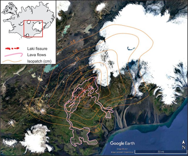
Isopatch map around the Laki fissure.
Map from Google Earth, Isopatch lines from Thordarson and Self (1993).
In the Fire District the tephra layers are usually larger than 0.5 cm, but increase towards the center of the eruption, where thicknesses can exceed 10 cm. At the fissures the thickness of the tephra layers increases quickly, growing up to 20 cm at the foot of cones and up to 300 m in the hills, where lava is absent. But ash clouds traveled much farther, than the shown isopatch, and during the eruption the whole island was covered in a submilimeter to milimeter thick layer of ash.
The total volume of pyroclastic material that fell within the 0.5 cm isopatch is estimated to be 0.620 km3. The volume of the more distal ash and dust has been estimated to be 0.127 km3. The total volume of Laki tephra is therefore 0.76 km3, which would be 0.4 km3 DRE. This represents 2.6 vol.% of the total volume erupted.
Tephra units were formed mainly by the early activity on each fissure and suggests that explosivity was largely caused by hydromagmatic interactions. Most of the water was supplied by a shallow groundwater zone, such as the bogs around the fissure site. In addition, the spatial grouping of cone types reflects the effect of magma-water interactions.
As each new fissure formed, it opened a pathway for the groundwater to contact rising magma and initiate explosions. As the water-content depleted the eruptive mechanism changes to strombolian until all the water is exhausted and effusive, hawaiian, activity dominates. The sharp contact between phreatomagmatic and strombolian tephra layers indicates that the change in behaviour (and therefore water table) occurred rapidly.
The effect of external water on the eruption behaviour was therefore the principal cause for the relatively wide dispersal of the Laki tephra layer.
The ash clouds advanced further than the Fire District and distal ash and dust formed a submillimeter- to a few millimeter-thick layer covering areas greater than 760,000 km2 (7 times the size of Iceland).
Next Part
In the next part, we will explore the environmental effects of the Laki eruption and see how far its influence reached over the shores of Iceland.
Previous posts
Geology of Iceland - Part 1: Introduction
Geology of Iceland - Part 2: The Iceland hotspot
Geology of Iceland - Part 3: an island being ripping apart
Geology of Iceland - Part 4: volcanic Systems
Geology of Iceland - Part 5: Magmas and Rocks
Geology of Iceland - Part 6: Volcano types
Geology of Iceland - Part 7: Eruption styles

References
- Jacoby, G.C., Workman, K.W., D’Arrigo, R.D. (1999). Laki eruption of 1783, tree rings, and disaster for northwest Alaska Inuit. Quaternary Science Reviews 18, 1365-1371.
- Oquilluk, W. A. (1973). People of Kauwerak: Legends of the Northern Eskimo. The third disaster (Ch. 5).
- Stothers, R. B. (1996). The great dry fog of 1783. Climatic Change 32, 79-89.
- Thordarson, T. and Self, S. (1993). The Laki (Skaftár Fires) and Grímsvötn eruptions in 1783–1785. Bulletin of Volcanology 55, 233–263.
- Thordarson, T. and Self, S. (1993). Atmospheric and environmental effects of the 1783-1784 Laki eruption: A review and reassessment. Journal of geophysical research 108.
- Thordarson, T., S. Self, N. Oskarsson, and T. Hulsebosch, Sulfur, chlorine,
and fluorine degassing and atmospheric loading by the 1783 – 1784 AD- - Laki (Skafta´r Fires) eruption in Iceland, Bull. Volcanol., 58, 205 – 225.
- Thordarson, T., S. Self, N. Oskarsson, and T. Hulsebosch, Sulfur, chlorine,
and fluorine degassing and atmospheric loading by the 1783 – 1784 AD-
Laki (Skafta´r Fires) eruption in Iceland, Bull. Volcanol., 58, 205 – 225. - Thordarson, T., Larsen, D., Steinþórsson, S., Self, S. (2003). The 1783–1785 A.D. Laki-Grímsvötn eruptions II: Appraisal based on contemporary accounts. Jökull 53, 11-48.
- Zeilinga de Boer, J. and Sanders, D.T., (2002). Volcanoes in Human History: The Far-reaching Effects of Major Eruptions. Princeton University Press, 295 pp.
This post has been voted on by the steemstem curation team and voting trail.
There is more to SteemSTEM than just writing posts, check here for some more tips on being a community member. You can also join our discord here to get to know the rest of the community!
Hi @sooflauschig!
Your post was upvoted by utopian.io in cooperation with steemstem - supporting knowledge, innovation and technological advancement on the Steem Blockchain.
Contribute to Open Source with utopian.io
Learn how to contribute on our website and join the new open source economy.
Want to chat? Join the Utopian Community on Discord https://discord.gg/h52nFrV
Congratulations @sooflauschig! You have completed the following achievement on Steemit and have been rewarded with new badge(s) :
Click on the badge to view your Board of Honor.
If you no longer want to receive notifications, reply to this comment with the word
STOP