Geology of Iceland - Part 3: an island being ripped apart
Introduction
Iceland is located on top of the boundary where the North American and the Eurasian plates are separating. These two plates move away from each other at a rate of 2 cm/year (1cm/year in each direction). By being located exactly on top of it, the eastern part of Iceland is constantly moving eastward with the Eurasian plate and the western part moves westward with the North American plate. The island is literally being ripped apart.
At the surface, the plate boundary forms narrow belts of active faulting and volcanism that zigzag across Iceland. This plate boundary is Iceland’s most magnificent geological feature, as it represents the only section of the Mid-Atlantic Ridge that is exposed above sea level (Figure 1).
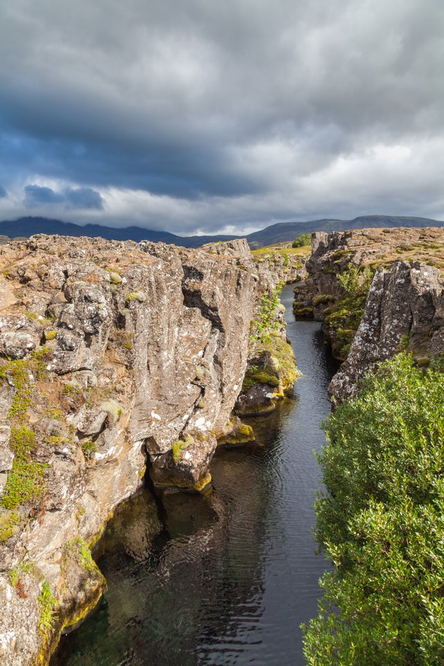
Figure 1. Flosagjá canyon, located in Þingvellir National Park in the West Volcanic Zone. Here the North American and Eurasian plate separate on land.
commons.wikimedia.org
The icelandic rift system
Above the plate boundary, the brittle crust forms wide cracks and faults where it is being ripped apart. They are orientated perpendicular to the spreading direction (105°E and 285°W at the location of Iceland). Here magma rises continually to fill the gap, forming vertical dykes that sometimes reach as far as the surface, where lava can erupt via fissures. The parallel dykes and fissures form swarms and combine into narrow belts, known as volcanic zones. The volcanic zones are connected by large transform faults known as fracture zones. If volcanically active, these fracture zones are known as volcanic belts. Together, all these structures cover roughly one third of Iceland (Figure 2).
The rip that runs through Iceland continues in submarine rift valleys to the south and to the north. In the south it is the Reykjanes Ridge and to the north the Kobeinsey Ridge. Both represent the segments of the mid-ocean ridge that continues on through the Atlantic ocean.
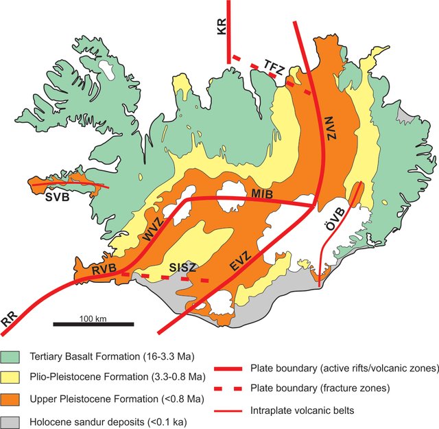
Figure 2. Geological map of Iceland, showing major geological subdivisions, main volcanic zones and belts as well as main fracture zones. RR, Reykjanes Ridge; RVB, Reykjanes Volcanic Belt; WVZ, West Volcanic Zone; MIB, Mid-Iceland Belt; SISZ, South Iceland Seismic Zone; EVZ, East Volanic Zone; NVZ, North Volcanic Zone; TFZ, Tjörnes Fracture Zone; KR, Kolbeinsey Ridge; ÖVB, Öræfi Volcanic Belt; and SVB, Snæfellsnes Volcanic Belt.
Modified after Thordarson and Larsen (2007), originally from Sæmundsson (1979).
The segment of the mid-ocean ridge that represents Iceland has a more complex structure than its submarine counterparts. The Reykjanes rift zone enters the island from the southwest, close to Reykjavík, and continues into central Iceland, where it appears to end. The Kolbeinsey rift zone does not even get that far. It enters on the north coast and seems to end right there. In the interior of the island, to the east of the two others, a third rift zone can be observed. This rift zone extends through the whole island from Vestmannaeyjar, an archipelago off the south coast, all the way to the north coast. All three rift valleys contain several swarms of fissures. East-west-trending faults stretch from the ends of the Reykjanes and Kolbeinsey rift zones towards the inland rifzone to the east. These faults generate frequent earthquakes.
At the Eastern Volcanic Zone, Iceland’s youngest volcanic rocks are produced. Most of them are emplaces along lava flows that erupt from fissures along the valley. Exact eruption sites vary regularly, when older fissures become clogged and younger ones open alongside them, providing new pathways for younger pulses of magma.
Structures related to rifting
The volcanic zones are generally 20-50 km wide. Here, magma production outweighs the amount of space opened up by plate movements. This results in the accumulation of the erupting lava. This accumulation is concentrated in the center of the volcanic zones. Lava quickly becomes buried by new eruptions forming steep topographic paths that become more and more shallow the further they are away from the spreading center. The weight disequilibrium caused by more material piling up in the center of the volcanic zone leads to downsagging of the crust. The surrounding piles of lava are therefore slightly tilted towards the spreading center. This tilt remains while the material is being pushed away by the spreading axis, forming a large shallow syncline (Figure 3). But Iceland is not just one single huge syncline, as would be expected from a constant spreading center. Reversals in dip directions indicate anticlines associated with major unconformities that position formations of different age next to each other. At a regular spreading center it would be a constant age progression away from the spreading axis. This means something is happening at Iceland that causes structural developments different from the usual age progression trends at ‘normal’ mid-ocean ridges.
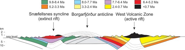
Figure 3. Schematic cross section showing the general structure of Iceland from the Snæfellsnes peninsula across the West Volcanic Zone. Accumulation of lava at the centers of the rifts leads to downsagging, forming shallow synclines and a shallow anticline in the area between the volcanic zones.
Modified from Thordarson and Höskuldsson (2014), originally from Jóhannesson, (1980).
Structures related to Rift-Plume interaction
The difference between Iceland and ‘normal’ mid-ocean rides has been addressed in my last post. Here I mentioned that the formation of Iceland resulted from the interaction of the spreading plate boundary and a more deeply rooted mantle plume. The overall morphology and geological architecture of Iceland is a direct result of this interaction and its interplay through time. The most obvious result has been addressed in the previous post. The fact that the plume caused the island to rise above sea level in the first place. But the complex structural developments that are observed in Iceland are also a result of this interaction.
Today, the center of the Icelandic mantle plume is located beneath the Vatnajökull icecap and underlies the top of the East Volcanic Zone. This has not always been the case. 24 million years ago the center of the mantle plume was located under the extrapolated intersection between the Reykjanes Ridge and the Kolbeinsy Ridge. The relative positions of the spreading axis and the mantle plume must have therefore changed with time.
The mantle plume itself is a stationary structure. This means that the location of the spreading axis must have changed through time. Calculations indicate that this migration happened at a speed of 0.3 cm/year towards west-northwest added on top of the actual spreading motion. As the spreading center moves away, the plume continues to push upward at its stationary location, thereby forming new rifts closer to its center. The rifts farther away gradually become inactive. This process is called a rift jump.
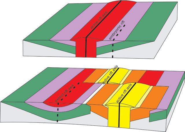
Figure 4. Simplified sketch showing the structural developments caused by a rift jump due to westward migration of the rift zone away from the stationary mantle plume.
Modified from Thordarson and Höskuldsson (2014), originally from Steinþórsson, (1981).
The currently active rifts are the West and North Volcanic Zones. The East Volcanic Zone is a new rift that is currently in its making. It will at some point in time take over for West Volcanic Zone as the main active rift. To the west, the precursor rift to the current active zones is observable as a broad syncline in the Tertiary succession of Snæfellsnes.
The key indicator for a rift jump is the trapping of older crust between two rift segments in combination with the overlap of activity between the newly forming rift segment and the at that point active rift segment. The sagging of the two rift zones leads to the formation of a broad anticline in the trapped crustal segment. The model therefore explains the geological observations made in Iceland very well.
Additional volcanic activity
Recent volcanic activity is not only limited to the three volcanic zones but also occurs in two active intraplate volcanic belts. The first one is the Snæfellsnes Volcanic Belt in western Iceland. It lies on the mantle plume trail and is superimposed on the extinct rift zone precursor of the West Volcanic Zone.
The second one is the Öræfi Volcanic Belt to the east of the plume center. It probably represents a new rift in its very early stages due to the continuous westward migration of the Iceland rift system. Maybe this indicates yet another rift jump across Iceland.
Previous posts
Geology of Iceland - Part 1: Introduction
Geology of Iceland - Part 2: The Iceland hotspot

References
- Jóhannesson, H. (1980). Jarðlagaskipan og þróun rekbelta á Vesturlandi. Náttúrufræðingurinn 50, 13-3.
- Thordarson, T. and Höskuldsson, Á. (2014). Classic Geology in Europe 3: Iceland. Second Edition. Dunedin Academic Press Ltd, 256 pp.
- Thordarson, T. and Larsen, G. (2007). Volcanism in Iceland in historical time: volcano types, eruption styles and eruptive history. Journal of Geodynamics 43, 118-152.
- Steinþórsson, S. (1981). Ísland og Flekakenningin. In: Náttura Íslands, 29-63. Reykjavík: Almenna Bókafélagið.
- Sæmundsson K. (1979). Outline of the geology of Iceland. Jökull 29, 7-28.
- Zeilinga de Boer, J. and Sanders, D.T., (2002). Volcanoes in Human History: The Far-reaching Effects of Major Eruptions. Princeton University Press, 295 pp.
- https://en.wikipedia.org/wiki/Þingvellir
- https://en.wikipedia.org/wiki/Vatnajökull
- https://en.wikipedia.org/wiki/Vestmannaeyjar
- https://en.wikipedia.org/wiki/Sn%C3%A6fellsnes
- https://commons.wikimedia.org/wiki/File:Ca%C3%B1%C3%B3n_Flosagja,Parque_Nacional_de%C3%9Eingvellir,_Su%C3%B0urland,_Islandia,_2014-08-16,_DD_043.JPG
Iceland should have been a big clue for the continental drift theory. Do you know if it was one of the places which helped to get the theory accepted?
Interesting that you'd mention this.
At the 1939 international geological conference in Frankfurt that addressed the early discussion of the continental drift theory (although led by opposers), a scientist names F. Bernauer presented his research on "Island und die Frage der Kontinentalverschiebung" (Iceland and the question of continental displacement). He made the suggestion that the Reykjanes Ridge and Mid-Atlantic Ridge had a common origin. He therefore proposed that the continents drifted apart along the Mid-Atlantic Ridge but (also being an opposer of continental drift) only to the extend of the modern volcanic activity on Iceland, so 100-200 km. He did not support the theory from A. Wegener, in which the Mid-Atlantic rift would have formed the complete seafloor.
summarized from : Frankel, H.R. (2012). The Continental Drift Controversy. Volume I: Wegener and the Early Debate. Cambridge. p. 408-409
It took the discovery of the global mid-ocean rift system and the magnetic polarity changes across the seafloor that strengthened the continental drift theory into acceptance.
Makes sense that Iceland was mentioned in the context of that theory, it would be hard to find a clearer example. I guess it makes sense that the theory had quite a lot of resistance, continents floating around does seem like a crazy idea
You received a 80.0% upvote since you are a member of geopolis and wrote in the category of "geopolis".
To read more about us and what we do, click here.
https://steemit.com/geopolis/@geopolis/geopolis-the-community-for-global-sciences-update-4
Can you get in touch with me on Discord or steem.chat please? Any time you can =)
Nice work. Very detailed indeed. I've really learned a lot about the geology of Iceland. Thanks for sharing!
Glad you enjoyed it :)
Congratulations @sooflauschig! You have completed some achievement on Steemit and have been rewarded with new badge(s) :
Click on any badge to view your Board of Honor.
To support your work, I also upvoted your post!
For more information about SteemitBoard, click here
If you no longer want to receive notifications, reply to this comment with the word
STOPDo not miss the last announcement from @steemitboard!
All these geological activities have such an impact that it is a bit concerning. When it does happen, it may cause devastating effects. People and places can disappear. In this age and time, it helps that we can collect information and conduct studies.
I feel I have attended a class or reviewed a lesson for a impromptu quiz lol! So much information.