Monsoon and the Factors Affecting the Monsoon | How Monsoon Works?👉
When the earth gets wet,
All sorrows when one forgets!
It is that time of the year again,
When you want to walk in the rain!!
When the fields are green,
Every face has a new sheen!
You will forget your every pain,
When clouds roar and it starts to rain!!
~Sumit Gupta
Source:
In 1686 AD an Englishman Sir Edmund Halley stated that the monsoon results from thermal contrasts between continents and oceans due to their differential heating.
It was a simple hypothesis which could not explain the various factors related to the monsoon.
Source:
During their journey towards northwards, the southeast trade winds change their direction to northeast under the influence of Coriolis Effect while crossing the equator. These winds are known as south-west monsoon in the Indian sub-continent. Monsoon fronts originate with the meeting of the south-west monsoons and the north-east trade winds and bring heavy rain.
During the end of the June ITCZ shifts to 20°- 25° N latitude and is located in the Indo-Gangetic Plain and the south-west monsoons start blowing from the Arabian Sea and the Bay of Bengal.
According to this theory shifting of the ICTZ is the main reason of the formation of the monsoon.
Studies of various scientists and meteorologists like Flohn, Thompson, Stephenson, Frost, M.T. Yin, Hwang, Takahashi, E. Palmen, C. Newton, P. Koteswaram, Krishnan, Raman, Ramanathan, Krishna Murti, Rama Rattan, Ramaswami, Anant Krishnan, etc. have contributed a lot in understanding of the mechanism of monsoon winds formation.
Recent studies of the upper atmosphere circulation have significantly changed the old concept. It is now believed that the differential heating of land and sea cannot induce the monsoon alone. Recent concept recognize the importance of various factors like upper atmospheric circulation, the Tibetan Plateau, jet streams, El-Nino, La-Nina, walker circle etc. along with the differential heating effect of the land and the sea in formation of the Indian monsoon.
Jet streams are the high altitude (9-12 km) westerly winds between middle latitude (summer 35º -45º N; winter 20º -35º N) in the Northern Hemisphere which are irregular, concentrated, meandering bands of geo-strophic winds, travelling at speeds of 300 to 400 KMPH.
Jet streams develop where air masses of differing temperatures meet. The velocity of the jet streams increases with the increasing different in temperature. Research shows they exert a considerable impact on surface weather conditions.
Source:
Tibetan Plateau acts as a physical barrier as well as a source of heat. A thermal anticyclone forms over the Tibetan Plateau because of receiving considerable heat during the northern summer. The formation of anticyclone weakens the western sub-tropical jet-stream south of Himalayas and produces tropical easterly jet on the southern side of the anticyclone. This tropical easterly jet stream first develops in longitude east of India and then it extends westwards across India and the Arabian sea to eastern Africa. Blowing along Kolkata-Bangalore axis the air under this jet descends over the Indian Ocean and intensifies the Ocean’s high pressure cell, so as toly move as south-west monsoon. Study shows that higher the intensity of the tropical easterly jet, greater would be the potency of the high pressure cell over the Indian Ocean and stronger would be the impact of south-west monsoon.
Source:
Jet stream extends up to 20º -35º N latitude due to the equator-ward shift of upper air north polar whirl during the winter and are bifurcated into two branches by the Himalayas and the Tibetan Plateau. One branch remains to the south of the Himalayas while the second takes position to the north of the Tibetan Plateau. The upper air high pressure and anticyclone conditions develop in the troposphere over Afghanistan and Pakistan. Consequently, the winds tend to descend over the north-western parts of India, resulting into the development of atmospheric stability and dry conditions.
The tropical easterly jet stream extends far to the north of Tibet and descends into the permanent high pressure area formed over the southern Indian Ocean which intensifies the already present ‘high’ pressure area there. Consequent to this high pressure cell the onshore winds starts blowing towards the thermally induced low pressure area, developed in the northern part of Indian subcontinent. These winds become south-westerly after crossing equator and known as the south-westerly monsoon which brings rain in the southern hemisphere.
These results infer that the easterly jet stream is directly related to the intensification of permanent high pressure over the Indian Ocean which makes the pressure gradient.
During summer, low pressure areas develop over Pakistan and north-west India due to intense heating of the ground surface starting from April but as long as the position of the upper air jet stream is maintained above the surface low pressure, the dynamic cyclonic conditions persists over Iran, Afghanistan, Pakistan and north-west India. The winds descend from the upper air high pressure obstructs the ascent of winds from the surface low pressure areas which results in dry and hot weather. This is the reason that the months of April and May are generally dry despite of very hot weather, low pressure and high evaporation.
It is an irregularly periodic variation in winds and sea surface temperatures over the tropical eastern Pacific Ocean which affects the climate of the tropical and subtropical areas. It has two phases-one warming and the other cooling. The warming phase of the sea temperature is known as El-Nino (means ‘Child Christ’ in Spanish) while the cooling phase is known as La-Nina (means ‘little girl’ in Spanish).
El-Nino is a high surface pressure in the tropical western Pacific, and La-Nina is an opposite condition. The two periods usually last for several months and occur every few years. Also, their effects vary in intensity and relate to Walker circulation which is also known as Walker Cell that is a conceptual model of the air flow in the tropics in troposphere region of the atmosphere. This model suggests that parcels of air follow a closed circulation in the zonal and vertical directions. Differences of temperatures between ocean and land cause this circulation.
Southern Oscillation is a seesaw pattern of meteorological changes which occur between the Pacific and the Indian Ocean. Whenever the surface pressure is higher over the Pacific (positive SO), the pressure over the Indian Ocean is low and vice versa. The low pressure over the Indian Ocean in the winter increases the chances of upcoming monsoon to be full of rain and when opposite happens it brings weak upcoming monsoon.
Source:
This oscillation has a period varying from 2 to 7 years. SO is closely linked with the Walker circulation. With a high positive SO, there would be a zone of low atmospheric pressure over Indonesian Archipelago and Australia. Large convective clouds and heavy rainfall accompany it.
Source:
In terms of global winds, the Walker circulation suggests a strong belt of convergence between the trade winds of both the hemispheres at a location slightly to the north of the equator. These trade winds pile up a huge quantity of warm water in the western Pacific, produce equatorial counter-current from the Indonesian coast and facilitate upwelling of cold water from below, near Peru coast, giving a ride to cold Peru Current.
Source:
In short, high positive value of SO shows a cold Peru Current, strong trade winds, accumulation of water in western Pacific which is balanced by the Equatorial Counter Current and under current, a rise in the depth of thermo-cline from the western half of the Pacific, and an ascending branch of the Walker circulation over Australia and Indonesia with its descending branch over South America. Such a normal condition leads to a normal south-west monsoon in India.
It is a warm ocean current appearing along the coast of Peru generally in December (especially during Christmas and hence, El-Nino ‘Child Christ’). It replaces the cold Peruvian current which flows along the Peru coast. El-Nino develops warm conditions over the Peru coast (eastern Pacific) and cold conditions in east of Australia and Indonesia (western Pacific). Whenever El-Nino appears, the amount of precipitation in the coastal areas of South America usually increases, while it brings drought conditions in the eastern coasts of Australia and Indonesia. It also affects monsoon in India. Its occurrence results in a weak monsoon which means less rainfall.
The appearance of El-Nino leads to a ‘warm phase’ of the Pacific or negative SO. With the appearance of it the ascending branch of the Walker Cell shifts to the central regions of the Pacific Ocean and the descending branch to the south-eastern parts of the Ocean. As upwelling off the South American coast decreases, the sea surface temperature rises because of not receiving cold water. This leads to weaker trade winds, less accumulation of warm water on the western half of the Pacific Ocean, weakening of the Equatorial under current, heavy rain and floods along the South American coast and poor monsoon or failure of monsoon over Indian Subcontinent.
The ENSO effect could maintain a statistical explanation of several past droughts in India of recent decades but now its relationship with the Indian monsoon seemed to be weakening somewhat. It was evidenced that the strong ENSO of 1997 did not cause drought in India. IOD is a recently discovered factor which affects the Indian monsoon. It is also referred as the Indian Nino. It is a condition in which the sea surface temperature of the western region of Indian Ocean becomes abnormally colder and hotter than the eastern region in alternative phases. IOD can neutralize or intensify the impact of El-Nino and La-Nina depending on the phases of it. Higher than usual temperatures of the western Indian Ocean is known as ‘positive’ IOD phase which brings more rain during monsoon and vice versa.
Source:
Source:
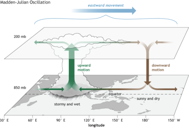
It was identified in 1971 by American scientists Roland Madden and Paul Julian. Its system still could not be fully understand but it is a phenomenon that occurs at a certain intersection of winds, clouds and pressure which brings rain to the different parts of the world as it moves around the equator. It moves as the ‘weather disturbances’ at different speeds around the world, taking one to two months, or even three months. Moving of MJO divides the world into areas of high and low rainfall. Parts of the world in which MJO is in the active phase receive more than usual rainfall while the other parts of the world faces less rain than the average rainfall. The good rainfall in the Indian subcontinent is also attributed to MJO passing over the Indian Ocean. Like IOD, it can also alter the impact of La-Nina and La-Nina.
Source:
Bursting of the monsoon is the sudden change in weather conditions in India which is characterized by an abrupt rise in the mean daily rainfall. During this phase extremely high rainfall is a common phenomenon.
Monsoon rain does not imply that it is a continual torrent of rain for months. In fact it has inter-seasonal variability. The periods in which a rapid succession of weather disturbances or storms are witnessed for a few days are called active periods and those periods are break periods when there is no rainfall for some days. During the active phase, the Tropical Easterly Jet Stream remains very strong in the upper troposphere which indicates strong convection and latent heating. During the break periods a weak easterly flow in the upper troposphere is seen. This condition generally last for three days to five days. Sometimes, this state can stay for months which become the harbinger of regional droughts.
The southwest monsoon generally begins around June and fades away by the end of September. On reaching the southernmost point of the Indian Peninsula, The moisture-laden winds are divided into two parts due to the topography of the region. One branch is known as the Arabian Sea branch and the other as the Bay of Bengal Branch.
Source:
Western Ghats region of Kerala receives heavy rain from the Arabian Sea branch of the Southwest Monsoon when the winds hit these old mountains. Then this branch of monsoon moves northwards along the Western Ghats and precipitate on those regions. However, the eastern parts of these mountains do not receive rain because of rain shadow effect of the Western Ghats.
The second branch of monsoon flows over the Bay of Bengal and heads towards North-East India and eastern parts of country after picking moisture from the Bay of Bengal. They hit the eastern Himalayas which brings heavy rainfall on these areas. With more than 11,000 mm annual rainfall, Mawsynram is the wettest place on earth which is situated on the southern slopes of the Khasi hills in Meghalaya (meaning the abode of clouds) state of India.
Being deflected by the Eastern Himalayas, these winds turns towards the west, travelling over the Indo-Gangetic plain, pour rain all along its way.
Normally, monsoon begin around 29th May of every year when it first hits Kerala. It reaches Delhi around 28 June and by the 15th July it reaches almost every part of the country.
Around September, when the sun moves rapidly towards south, the northern land mass of the Indian subcontinent begins to cool off rapidly. This starts air pressure mounting over northern India while the Indian Ocean and its surrounding atmosphere still holds its heat. It develops a pressure gradient which causes cold winds to sweep down from the Himalayas and Indo-Gangetic Plain towards the vast spans of the Indian Ocean south of the Deccan peninsula. This phenomenon is known as the Northeast Monsoon or Retreating Monsoon.
Source:
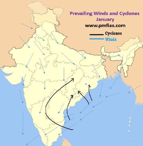
While travelling towards the Indian Ocean, these dry cold winds pick up some moisture from the Bay of Bengal and pours it over peninsular India and parts of Sri Lanka. Cities like Chennai, which get less rain from the Southwest Monsoon, receive ample rain now. Tamilnadu receives about 50% to 60% of the total annual rainfall from the Northeast Monsoon. Northeastern monsoon takes place from December to early March in Southern Asia when the surface high-pressure system is strongest. In this region the jet stream splits into the southern subtropical jet and the polar jet. The subtropical flow directs northeasterly winds to blow across southern Asia, creating dry air streams which result in clear skies over India. Meanwhile, monsoon trough, a low pressure system, develops over South-East Asia and Australasia which directs winds toward Australia.
Consequence of the rapid warming in the Indian Ocean, and changes in land use and land cover a weakening monsoon circulation was evidenced since 1950s in the South Asian region which gradually declined the rainfall over central India. The rising ocean temperature weakened the moisture-bearing winds from the ocean to the land that resulted in rain scarcity over the central India. It has grave consequences as the agriculture of this region is largely rain-fed.
However, a change has been seen in the land warming pattern during 2002-2014 which is increasing and possibly reviving the strength of the monsoon circulation and rainfall. During 1950 to 2015 incidents of widespread extreme rainfall were witnessed in the central belt of India. This region witnessed severe rainfalls and many incidents of flash floods in this year.
Many parts of India receive almost 85% of annual rainfall in the rainy season. Monsoon recharges the underground water reservoirs and the Himalayan glaciers which maintain the continuous flow of many perennial rivers like the Ganges, the Yamuna, the Sind, the Brahmaputra etc., of northern and eastern India, Pakistan, Bangladesh, Myanmar etc. India is an agricultural oriented economy in which 70 percent population is engaged. Without active monsoon this part of the world faces a severe drought which affects the living of the people badly. This is also true for Sri Lanka, Pakistan, Bangladesh and other neighboring countries of India. Monsoon affects the environments, economic, cultural, social and even political environment of these countries. Hence, monsoon is very important for the entire Indian subcontinent.
Credit:
https://aspirantforum.com/2015/02/08/monsoon-and-tibetan-plateau/
https://en.wikipedia.org/wiki/Walker_circulation
https://en.wikipedia.org/wiki/El_Ni%C3%B1o%E2%80%93Southern_Oscillation
http://geographyias.blogspot.com/2011/04/jet-stream.html
https://weather.com/en-IN/india/monsoon/news/2018-06-14-understanding-the-forces-behind-the-monsoon
https://en.wikipedia.org/wiki/Monsoon_of_South_Asia
https://en.wikipedia.org/wiki/El_Ni%C3%B1o
https://en.wikipedia.org/wiki/Monsoon
http://www.yourarticlelibrary.com/monsoon/monsoon-classical-and-modern-theories-of-monsoon/13835
Also, my school text books.
Thanks!
This post has been rewarded with 100% upvote from @indiaunited-bot community account. We are happy to have you as one of the valuable member of the community.
If you would like to delegate to @IndiaUnited you can do so by clicking on the following links: 5SP, 10SP, 15SP, 20SP 25SP, 50SP, 100SP, 250SP. Be sure to leave at least 50SP undelegated on your account.
Please contribute to the community by upvoting this comment and posts made by @indiaunited.
How Cool!
You got a 14.29% upvote from @coolbot courtesy of @socialbutterfly!
Help us grow, delegate today!
The post was interesting and nice. 🌹🌹
I enjoyed reading your post. I wish you success. 🌹🌹🌷🌷🌻🌻
Thank you @raha.
You got a 3.71% upvote from @t50 courtesy of @socialbutterfly!
Anyone can use this service by sending a minimum of 0.010 SBD or STEEM to @t50 with the post you want upvoted as the memo.
Consider investing Steem Power to receive daily payouts from bot income.
10 SP, 25 SP, 50 SP, 75 SP, 100 SP, 125 SP, 150 SP, 200 SP, 250 SP, 300 SP, 350 SP, 400 SP, 450 SP, 500 SP, 600 SP, 700 SP, 800 SP, 900 SP, 1000 SP or use the delegation manager. At any time you can get your investment back by undelegating.
Partners
@upfundme and #upfundme
TASKMANAGER bitshares token
@hybridbot - bid/membership hybrid bot (0.010 SBD minimum)
@memearmy meme support community bot
BOING! You got a 3.20% upvote from @boinger courtesy of @socialbutterfly!
Congratulations @akdx! You have completed the following achievement on Steemit and have been rewarded with new badge(s) :
Click on the badge to view your Board of Honor.
If you no longer want to receive notifications, reply to this comment with the word
STOPTo support your work, I also upvoted your post!
Do not miss the last post from @steemitboard:
SteemitBoard World Cup Contest - The results, the winners and the prizes