Part One - Using Avenza Maps and QGIS to create a base map for treaure hunting

We are fortunate to live in an age where we have free access to software allowing accurate location data capture with GPS and the tools to add attribution, run analysis, and output digital base maps we can use on smartphones for future navigation. Better yet, there is hidden treasure all around us waiting to be found by curious explorers.
This means we don't have to rely on apps like Google maps / Apple maps recording every move we make 🌍

Avenza maps is handy smartphone app which allows the import of custom base map layers, which you can download from the Avenza map store (many free samples are available), or create yourself on a PC using the open source mapping software QGIS.
Install Avenza maps
IOS - https://itunes.apple.com/app/apple-store/id388424049?mt=8
Android - https://play.google.com/store/apps/details?id=com.Avenza
Download a local basemap
A range of maps are available at https://www.avenzamaps.com/maps/search.html
Some are free, and most are much cheaper than the paper equivalent.
Alternatively you can easily make a custom map for your area of interest using QGIS and OpenStreetMap (OSM) layers.

QGIS is a powerful tool which grants you the ability to create maps, compare features, calculate statistics, and perform geoprocessing tasks on spatial datasets. It is also highly extensible though a large library of open source plugins created and maintained by the community offering added functionality.
Install QGIS - https://qgis.org/en/site/forusers/download.html
Treasure Hunt!
Below is an example of how we can use the above software to set up a riverside geocache, capture its GPS coordinates using the Avenza app, and then create a custom map in QGIS to help treasure hunters find the riches within 🎁
Creating a quick basemap in QGIS
Open a new QGIS project, and select Plugins > Manage and install plugins.
Search for and install the QuickMapServices plugin (QGIS v3.2) or the OpenLayers plugin (QGIS v2.18)
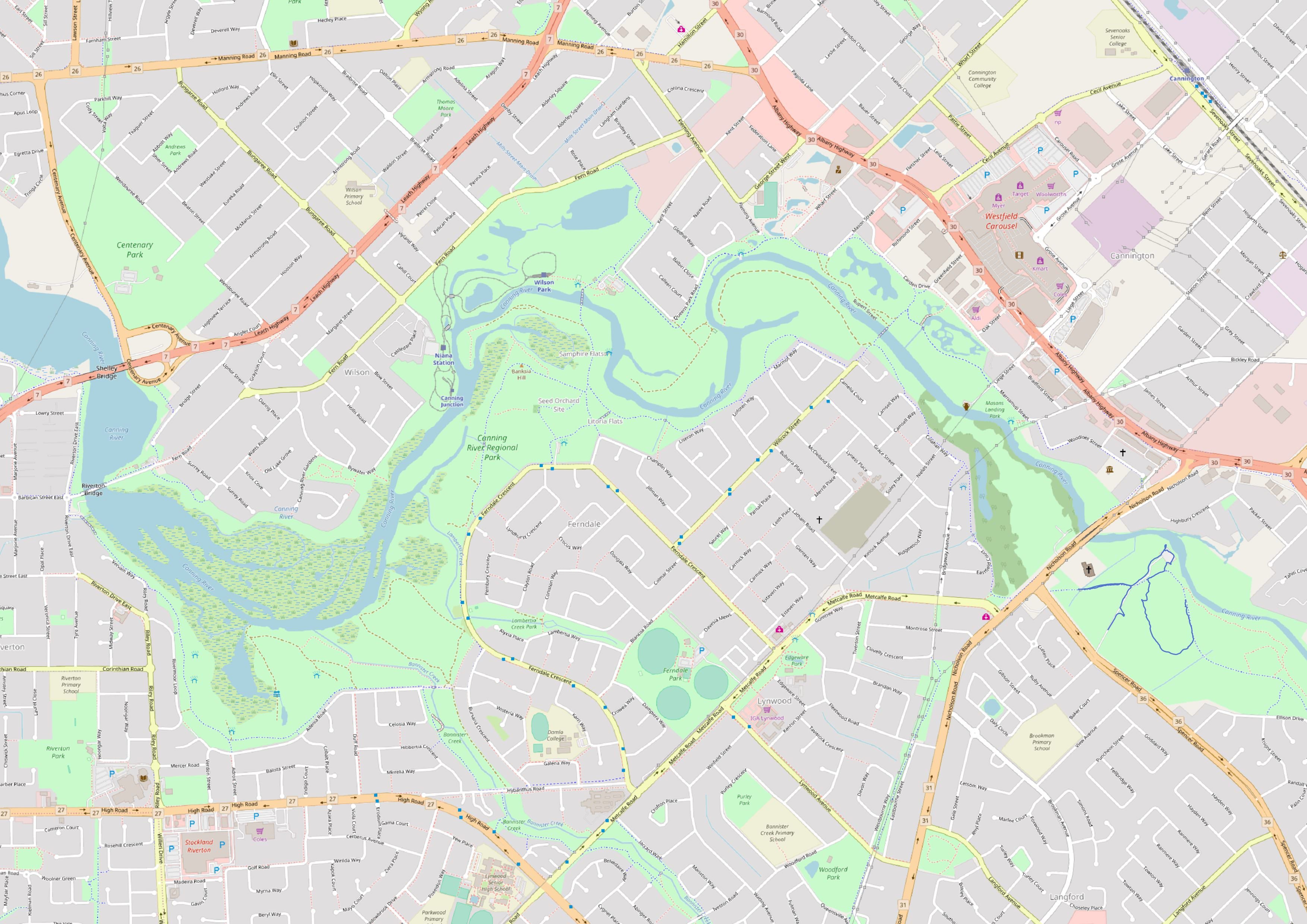
Look through the plugin menus, and select a basemap layer. I"ll use OSM Standard from the Web> QuickMapServices>OSM menu, and have positioned it over a section of the Canning River Park in Perth, Western Australia. It's a great spot for kayaking, cycling, and walking your dog. There are also many places along the river to hide our treasures 🍄

Credit: Canning River to Deep Water Point", by Peter Hyatt
Once you've loaded a basemap and moved it into position, go to Project > New Print Layout. Leave the title blank and click OK.

Look for the "add new map" icon, click it and draw a rectangle the size of the print layout canvas, then go to Project > Export as Image, set the file type to TIF and save your map image. QGIS will embed coordinate system information into the image file's metadata, which allows it to be displayed in the correct area when we import it in to the Avenza app on our smartphone and activate the GPS. 🎯
Importing your basemap into Avenza
Avenza maps is integrated into Dropbox, which is a convenient place to store your maps and easily share or retrieve them from the cloud. You can also import maps from the device storage, or via a USB cable, a web address, or QR code. Follow the links below for more details -
IOS - http://help.avenzamaps.com/customer/en/portal/articles/2936861-importing-a-map-ios-
Android - http://help.avenzamaps.com/customer/en/portal/articles/2934897-importing-a-map-android-
Depending on the size of the map you create, it might take a few minutes to process and tile the image. 🐌

Now we can turn on the smartphone GPS, and our location will appear over our base map
Avenza also allows us to record tracks, waypoints and placemarks. In part 2, we'll go for a walk, hide some treasure, and mark the locations. To add a little challenge for treasure hunters, instead of giving full coordinates, we'll only give the first 3 decimal places in decimal degrees. Nearby monuments or signage can offer extra hints to help narrow it down 🚸

Continue to...
Part Two - Hidden treasure in your local parks: using Avenza maps to GPS your geocaches
Part Three - Exporting Avenza Maps catured GPS tracks and placemarks into QGIS
Part Four - Artistic styling in QGIS to create a geocache treasure map (coming soon)
Hello smk762!
Congratulations! This post has been randomly Resteemed! For a chance to get more of your content resteemed join the Steem Engine Team
That's interesting! But I didn't get it, is this map more interactive, or it just allows you to track your route?
Since it's just a base map for treasure hunting, I think that it's enough just to track people's routes. But I think on any interactive map, you still can enter map coordinatesand see a specific location on our planet. In general, maps already record every move we make, so I think this interactive map does it on purpose.