Travelblog Peru part IV: Colca Canyon and lake Titikaka
Colca Canyon is located approximately 160 kilometers from Arequipa by car it can be a day's drive. The road (hightway)to the canyon is very good but A lot of roads on the side of the canyon are dusty dirt roads. And off course you stop a lot to enjoy the beautiful and stunning views ore the little colorful villages!
The canyon is more than twice as deep as the Grand Canyon but the walls are not as straight as the Grand Canyon. The deepest part of the Canyon is 3501 meters deep (11400 feet).
.jpg)
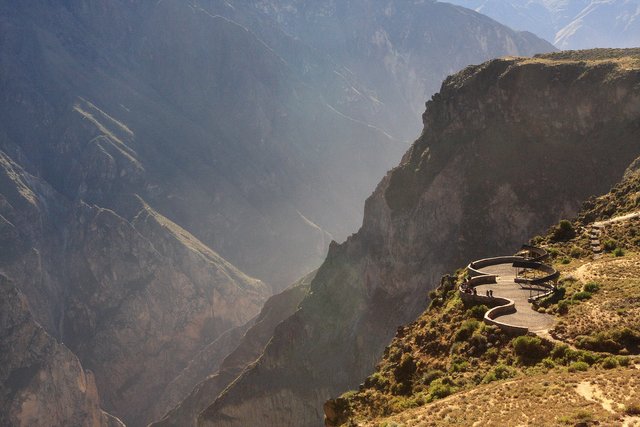
One of the stops that you have to make is mirador cruz del condor! A stunning view point on a narrow part of the canyon! Cruz del Condor is a very tourist place, where you can get very close to the condors. The gorge is the habitat of the Andes Condor, a protected species.
In the morning and evening the condors sometimes fly past you only five meters away. It is not really flying what they do, they float through the air on the warm air term, they are literally carried by the warm air!
This is possible because of the big wings they have. Probably the biggest wings of any animal alive today. They can have a span of more then 3 meters!
.jpg)
.jpg)
From there we went to the town of Cabanaconde! A small town with a beautiful central square with a fountain!
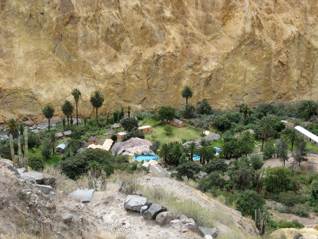
from that town we booked a tour down to the bottom of the canyon to a place called Sangalle .
there is an oasis of tranquility, a beautiful camping terrain with hammocks, palm trees and the river Colca lapping past your house. And don't forget the pools. The hike is about a kilometer down. but it takes more than 3 hours. It is a steep and winding descent. very early in the hike you can see the pools. That is a good prospect because it was hot that day!
There are three Eco lodges down there where you can spent the night. The food is very good an they have cold beers :D The next morning you know what was waiting for you. The hike back upp. But that was much essayer than down I don't like to hike down.
.jpg)
Link the location [//]:# (!steemitworldmap -15.583427 lat -72.022828 long d3scr)
From there we got in the car and drove a little back to Puno. That's a town located on the banks of lake Titikaka. A large, and deep lake in the middle of the Andes on the border of Bolivia. It's often called the "highest navigable lake" in the world. By volume of water and by surface area, it is the largest lake in South America.
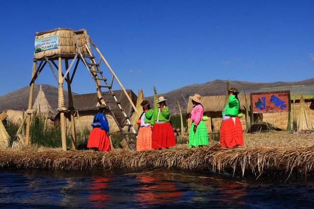
From Puno you can take a lot of trips on to the lake. I don't think you can do wrong here. It's one big tourist trap! That because of the people living on the lake on "floating Islands" It are small, man-made islands constructed by the Uros people made from layers of buoyant reed that grows in the shallow parts of Lake Titicaca. The Uros harvest the reeds and make the islands bigger by continuously adding reeds to the surface. The reeds on the bottom of these islands dissolve away! Watch out, this is a real tourist trap. People live there for one week to entertain the tourists and than they go home. I don't think they real live there these days but it is nice to see how they did't in the past!
.jpg)
Our boat brought us to the island of Taquile. It's a hilly island in the middle of the lake! It is narrow and long and during the Spanish occupation the whole island was a prison. In 1970 it became the property of the people of Taquile!
The highest point of the island is 4050 meters (13400 feet) above sea level and the main village is 3950 meter. (13000 feet) From the boat there is a steep, dusty road right to the top of the island! Its a brutal climb so high above sea level.
If you walk up you are continuously overtaken by carriers with a huge supply of the island on their backs.
They walk up as if it is nothing. trust me, it was killing.
.jpg)
But once arrived on top of the Island, the view was also fantastic. you could see all the snowy peaks of the Andes mountains in Bolivia.
a.jpg)
aa.jpg)
Next blog will bring us to Machu Picchu!
Questo post è stato condiviso e votato all'interno del discord del team curatori di discovery-it.
This post was shared and voted inside the discord by the curators team of discovery-it
Thank you :)
Congratulations, Your Post Has Been Added To The Steemit Worldmap!
Author link: http://steemitworldmap.com?author=haastrecht
Post link: http://steemitworldmap.com?post=travelblog-peru-part-iv-colca-canyon-and-lake-titikaka
Want to have your post on the map too?
Hiya, @LivingUKTaiwan here, just swinging by to let you know that this post made into our Top 3 in Daily Travel Digest #711.
Your post has been manually curated by the @steemitworldmap team and got an upvote from @blocktrades to support your work. If you like what we're doing, please drop by to check out all the rest of today's great posts and consider supporting us so we can keep the project going!
Become part of the Haveyoubeenhere community:
Thank you so much :) I love this!
What an adventure! The ehancement on the skirts is perfect! Good eye @steemitworldmap. Congratulations on the mention @haastrecht.
Thank you so much :)
very cool photo review. I forgot when I saw the blue colours like that! appreciated and upvoted.
Thank you, you mean the blue sky? That was awesome on that altitude!