Manali-Leh Highway “The Rooftop of Great Himalayas”
The Famous Manali-Leh Highway (National Highway-21) takes you away from the convenient world in such a rugged wilderness where the highway makes your mind and body a playground and hit you hard with AMS (Acute Mountain Sickness). The highways give you the experience of another planet while staying on earth. Manali-Leh is 480 km Long highway connects Himachal Pradesh with Jammu & Kashmir. About 6-7 months out of the twelve months of the year, it is cut off from the whole world due to heavy snowfall. Every year in May-June, the tireless efforts of the Border Roads Organization (BRO) makes alive the highway.
The Toughest Highway of the world "Manali-Leh Highway"
The only time between May and June is that when the rest of the world put the steps on this road. This unique highway has to enter in hibernation mode as soon as snow starts in October every year. The 5 high motorable mountain passes are the heirs of this highway, of which Tanglang-La is considered the world's second highest motorable pass, and the two lakes are believed the eye of the highway. These 5 passes are the pride and glory of this highway. The average height of this highway is 4000+ m from sea level, which decorates this as a toughest highway in the world. It is claimed that this highway is the highest motorable road in the world but I think according to recent analysis “Semo La” in Tibet is the highest motorable highway in the world.
Geographic features
It cannot be said in terms of its specialty because it is very special in itself. The snow-covered Pir-Panjal range, which is visible from Manali, forces the tourists to cross it. Located in the same range, the Rohtang-La gives the delightful view of Lahaul valley. Many big waterfalls can be seen in this valley, perhaps due to these, the valley looks so green and adorable. As soon as crossing Jispa, landscapes begin to change like the speed of lightning. Due to the absence of rain, the mountains situated on the banks of the river are brown and very dry, even though these peaks are covered with snow for the whole year and every day produces imaginary scenes with the sun's first ray.
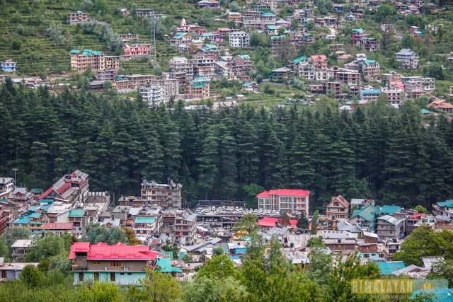
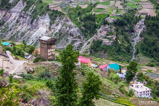
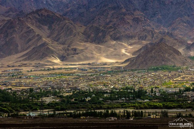
Manali town - 1950 meter
The BRO (Border Road Organization) has made this highway two-lane by working under difficult conditions, somewhere even now the road is only one-lane. Most of the road is made of tarmac, but where there is mad streams flowing, there is always the condition of highway is very bad. There is no divider on many segments on the road due to that, the possibility of accident always remains. The highway is addiction among Motor bikers and Cyclists, if you visit the highway then you’ll see that thousands of bikers and cyclists crossed this toughest highway.
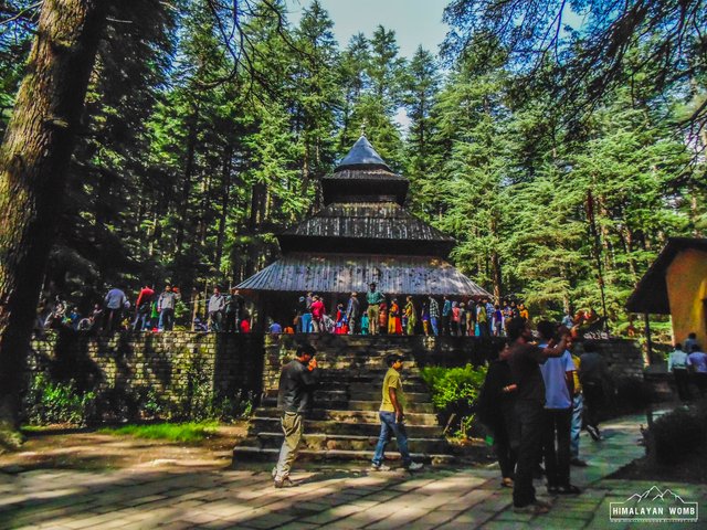
Hidima Temple at Manali town
The Five Pass
On this holy land of Buddhist and lamas, LA is called the “Mountain Pass” in local language. This highway is equipped with 5 high mountain passes in the world. Let's know about them.
1. Rohtang La (3980 Meter)
The first pass on this highway is Rohtang, which connects Kullu Valley to Lahaul-Spiti. This pass is 51 km from Manali town, situated in the east of the Pir-Panjal mountain range, located on 3980 meters. This pass is said to be mainly "A PILE OF CORPSES”. It is said that earlier due to the sudden bad weather, many people lost their lives while crossing the pass in winters. Crossing the highway, this is the only one pass where most tourists come to visit.
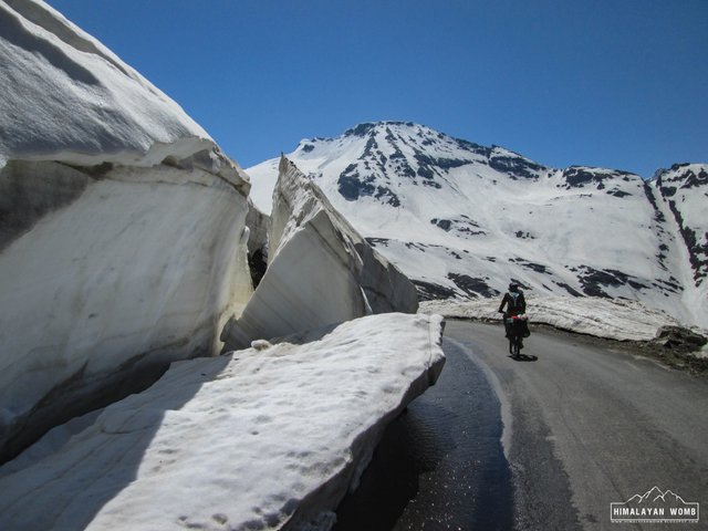
The Snow walls at Rohtang Pass - 3980 Meter
According to information from the Himachal Pradesh tourist department, in the year 2008 about hundred thousand tourists came to cross this pass in just 40 days. Due to increasing vehicles and tourists, about 2000 kg garbage is being removed in summers on every weekend. In order to establish balance in the environment, the Himachal Pradesh government has imposed a ban on reaching here. According to the latest information, now a total of 1400 cars can be reach here in a single day, in which 800 petrol cars and 600 diesel cars. And according to another initiative now Rohtang pass will be close for tourists on every Tuesday.
While descending the Rohtang pass towards Lahaul valley, it connects with Spiti at Kunzum Pass (4590 meters) and on other side the valley leads to Udaipur and Sarchu, which goes further to Leh. There are pretty much to see in Lahaul valley like, Koksar village, Sissue, Tandi, keylong and Jispa.
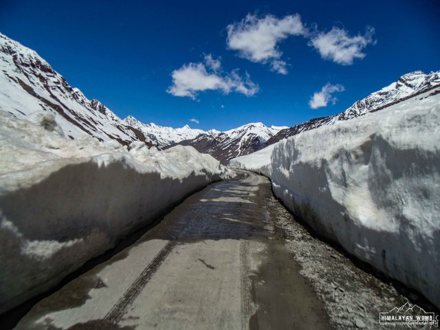
.JPG)
Rohtang Pass - 3980 meter
2. Baralachla (4890 Meter)
The second pass on Manali-Leh highway is situated on 4890 meters, situated in Zanskar mountain range, which connects Lahaul district, Himachal Pradesh to Ladakh in Jammu & Kashmir. The pass is 190 km far from Manali town and the originate of two rivers, Tsharap and Bhaga. Tsharap goes towards Zanskar and tributary Bhaga comes to Lahaul valley and conflicts in Chandra river at Tandi village, this confluence is so famous in India as “Chandrabhaga river”. Bhaga river originates from Suraj taal which is just few kilometers from the high pass.
The Beautiful Lahaul Valley
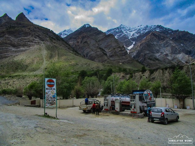
The Last Petrom Pump at Tandi - 2570 Meter
According to the legends there were two lovers in history, Chandra was the daughter of Moon and Bhaga the son of Sun God. So to get marriage they start climbing Baralchla pass from different directions, Chandra reached Tandi after covering 115 km and soon Bhaga meets the Chandra at Tandi after great struggle of 60 km, where they got married.
There are few trekking routes as well goes from here, one can reach Zanskar mountain range from here with a 7-8 days trek, Chandratal can be reached from here by 3 days trekking and there is a very young peak of 6000 meters which is getting famous very slowly among trekkers, Mount Yunam (6040 meter). By the way I have already been climbed this peak last year (July 2018).
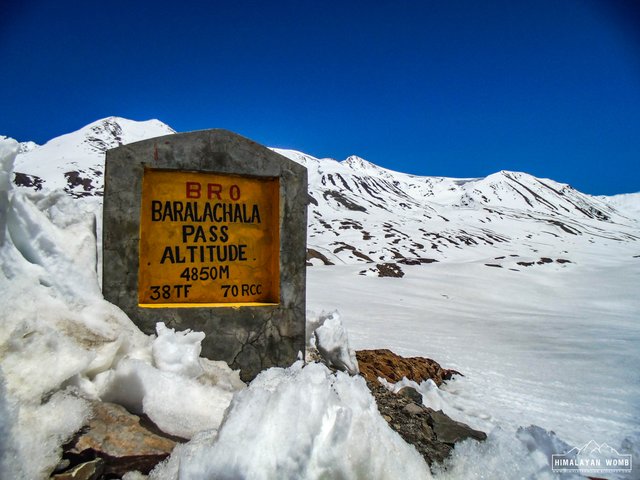
Baralchala Pass - 4890 Meter
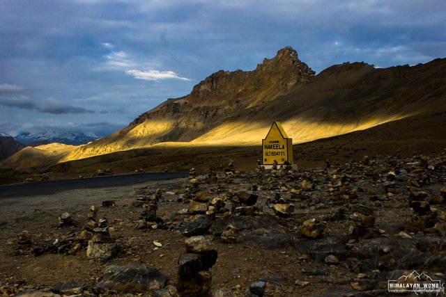
3. Nakee La (4769 Meter)
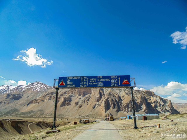
Nakee la is the third mountain high pass from Manali side on this highway. It is situated on and situated on Himachal Pradesh & Jammu & Kashmir state border in Zanskar mountain range of Leh, Jammu & Kashmir, located on 4769 meters from sea level and 268 km far from Manali town. The pass lied between Sarchu and Pang, small local and Indian army establishments also available there.
The ascent to the pass is crossed from another epic segment of this highway “Gata loops”, the rough 21 hairpin bends which leads to steep Nakee la. This is the second pass on this highway from where no river or stream goes. Sarchu is a small place where tourists can get the good and accommodation. Sarchu is state border and divides the Himachal Pradesh to Jammu & Kashmir and this establishment remains only in summers for few months.
The Unique Mud Structure at Sarchu
Sarchu State Border Of Himachal Pradesh and Jammu & Kashmir
Nakee La - 4769
4. Lachungla (5059 Meter)
Forth mountain pass in this five passes series from Manali side. The pass is 278 km away from Manali town and 54 km from Sarchu. The first 5000+ meter from Manali side and it is the second highest pass among five mountain passes. The road is not good up to Pang, it is narrow and walks along with river up to pang. Like every other pass of Ladakh region this pass is also decorated with the colorful Buddhist prayer flags. It is advisable not to spend lot time on the pass due to lack of oxygen. It is said that the oxygen level here is down up to 40%, it happens because the landscapes are there without vegetation.
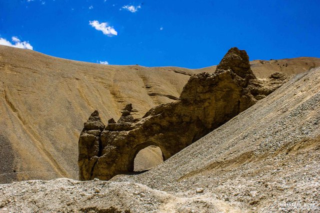
The Famous Natural Arc Before Pang
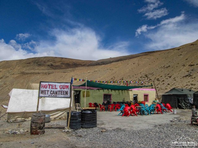
Pang
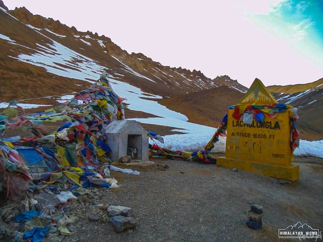
Lachungla - 5059 Meter
5. Tanglung La (5328 Meter)
Here is the fifth and last pass of this epic highway. Tanglung la is located on 5328 meters, is a high mountain pass in Ladakh region of Jammu & Kashmir. It is claimed by Shuttle Radar Topography Mission (SRTM) that this is the second highest motorable mountain pass on earth, first is Khardungla which is also in Ladakh region, located on 5602 meters, but this claim is no longer correct, now it is 12th highest motorable mountain pass, so Tanglung la is 13th highest motorable pass in this series. The pass is 368 km from Manali and 110 km away from Leh town.
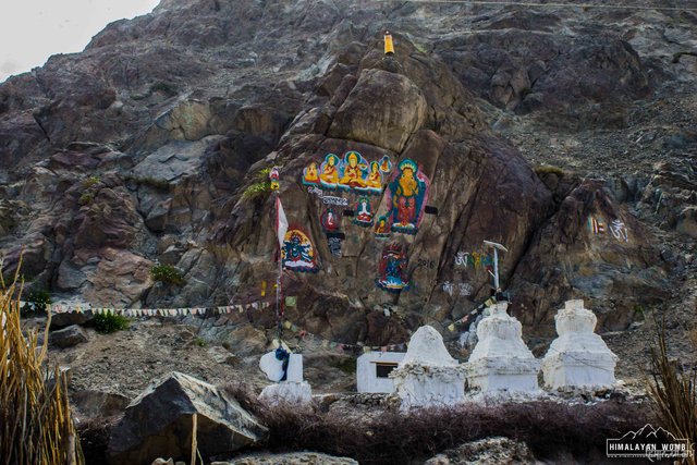
It is very fascinating pass due to its elevation, it offers some beautiful backdrops of snow caped mountain ranges. When you stand on pass and see towards Leh then you can see all the 6000 meter plus high peaks, in which there are many peaks need to be climb. There is a “All Religion” temple also on the top. I remember when I was crossing this pass on my Mountain Bike, it was so pain for me due to its altitude, broken road and above all it was heavy snowfall that time.
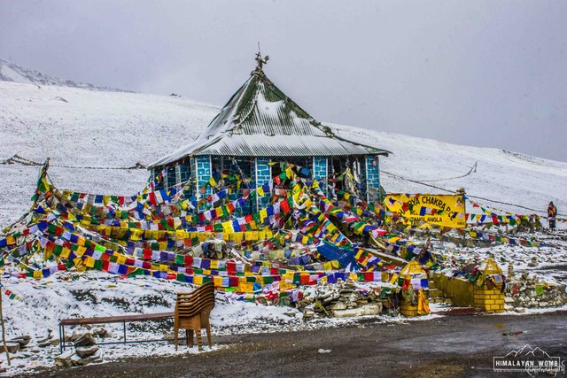
All Religion Temple At Tanglung La
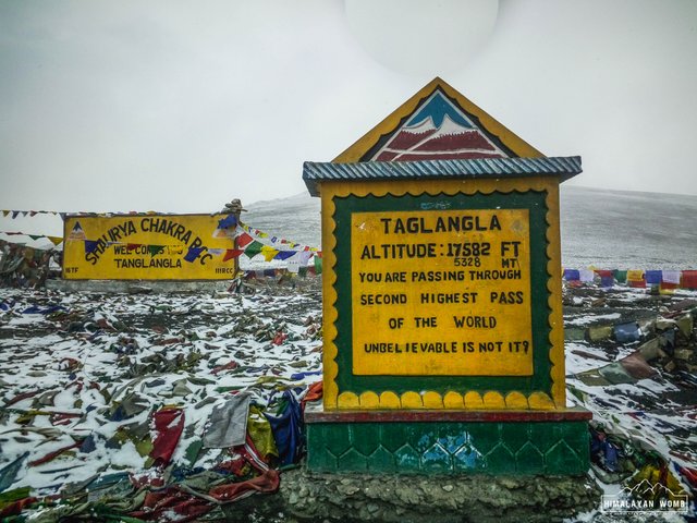
Tanglung La - 5328 Meter
I also want to discuss about two most iconic place on this highway, which are “Moray Plains and Gata loops”.
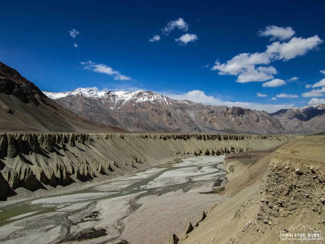
Moray Plains (4800 Meter)
Moray plains almost 302 km from Manali towards Leh town. It is located on and average on 4800 meters from sea level. It is about a 40 km long flat stretch and flanked by mountain range on both sides. At some places it runs along with Sumkhel Lungpa river. It is called “Kyanguthaang” in local language, while crossing the moray plains one can easily encounter the Himalayan Kyang animal, they live around there because it is some vegetation available in the plains.
According to me it is a magical place between high trans Himalayan ranges, it suddenly appears just after 4 km of uphill from Pang. It is almost flat road up to Debring (4750 meter) (Small local establishment) and from here it again starts to rise to Tanglung la. It is two lane road here and most famous segment among bikers. There are no establishment, no construction and even no population here.
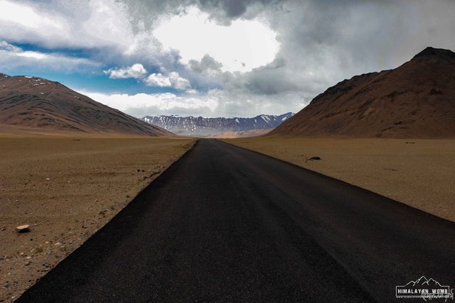
The Fabulous Moray Plains
Gata Loops (Start Point: 4201 Meter, End Point: 4667 Meter)
Gata loops comes just before Nakee la and after the Sarchu state border. It is a 14 km long stretch with 21 hairpin bends. The Gata Loops pretty much mysterious attraction among tourists due to some scary incident which had happened long time ago here. It is said that “Once a truck stuck between Gata Loops, driver send his partner to nearest town to get help and when his partner doesn’t find any help around then he returns to truck but the truck was not there. It has been fell down in gauge with driver. He checked out this partner and he was no more, and suddenly he got heart attack and he also lost his life there. So now it is believed that their ghosts are still there. So, in both memory tourist offers water bottle at one place.
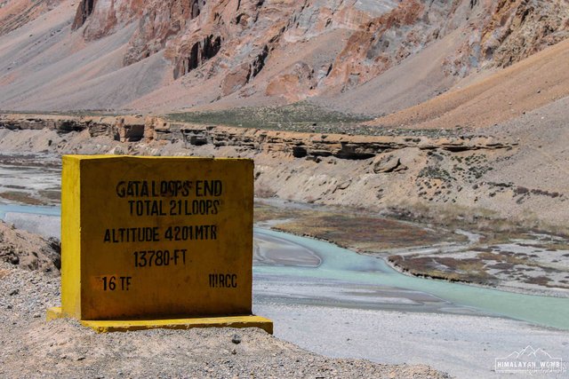
The Start Point Of Gata Loops - 4201 Meter
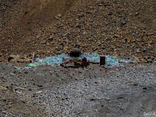
The Ghost Place At Gata Loops
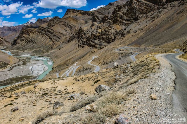
The Epic 21 Hairpin Bends Of Gata Loops
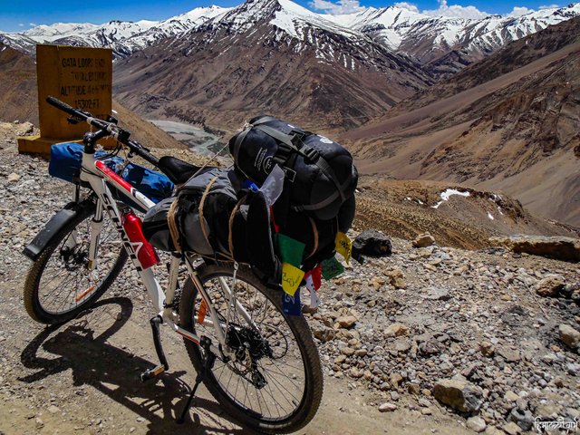
Top Point/End Point Of Gata Loops - 4667 Meter
And in last the “Two Eyes of Highway” (Lakes of Highway). Cycling on Manali-Leh highway was not a joke; I was alone, but I trusted myself and had gone out in June 2014 with my bicycle. On this trip, I saw 2 high altitude lakes, the first was
Suraj Taal and the other Deepak Taal
Suraj taal (4890 Meter)
Suraj Taal is located on the altitude 4890 meter. It is a high-altitude lake in Trans Himalayas, lied in Lahaul, Himachal Pradesh, about 188 km far from Manali town. It is a sacred body of water with aqua water. Suraj taal means the Lake of the Sun God, and it lies just before the Baralacha-la pass. It 21st highest lake in the world. Suraj Tal Lake is the source of Bhaga river which joins the Chandra River at Tandi town.
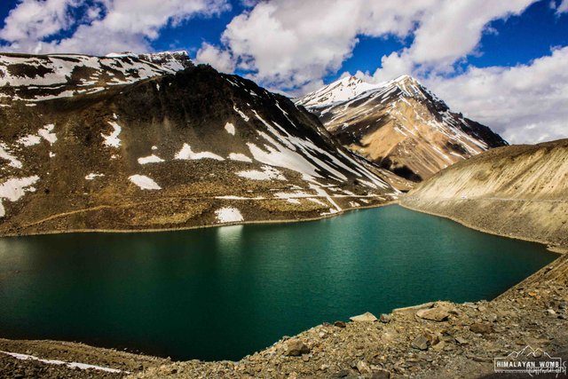
Suraj Taal - 4890 Meter
Deepak taal (3750 Meter)
Deepak taal is a small lake on altitude of 3750 meter, and about 50 km from Keylong town situated on NH-21. The lake falls between the Rohtang Pass to Keylong town. The water of lake is like a beautiful blue sapphire. While visiting the lake you can stop there for a while and enjoy the hot tea at small Dhaba (Restaurant) situated next to lake.
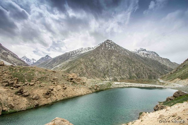
Deepak taal - 3750 Meter
So, it was the experience of this epic Manali-Leh highway. If you have not been there, I hope you should. It is totally another planet exists here. I have visited this highway first time in 2014 by my bicycle. It was a self-supported cycling trip up to Leh. In 2016 I visited the highway twice by car, once in 2017 and again once in 2018. Well waiting to open it again so that I can again go there and enjoy the Trans Himalayan beauty.
The Walls Of Leh Palace On The Way To Leh Town
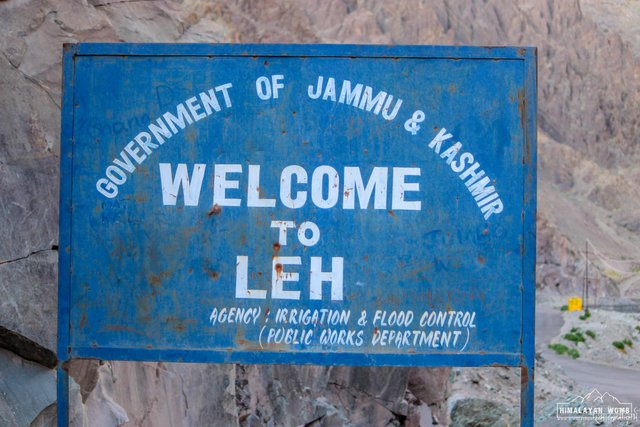
Welcome To Leh
The Dry Desert - Leh
Thanks for reading the blog.
Julley (Hello in Ladakhi Language)
Love Nature,
Love Himalaya…
Congratulations! This post has been upvoted from the communal account, @minnowsupport, by himalayannomad from the Minnow Support Project. It's a witness project run by aggroed, ausbitbank, teamsteem, someguy123, neoxian, followbtcnews, and netuoso. The goal is to help Steemit grow by supporting Minnows. Please find us at the Peace, Abundance, and Liberty Network (PALnet) Discord Channel. It's a completely public and open space to all members of the Steemit community who voluntarily choose to be there.
If you would like to delegate to the Minnow Support Project you can do so by clicking on the following links: 50SP, 100SP, 250SP, 500SP, 1000SP, 5000SP.
Be sure to leave at least 50SP undelegated on your account.
Thank you
Posted using Partiko Android
Hi, @himalayanwomb!
You just got a 0.05% upvote from SteemPlus!
To get higher upvotes, earn more SteemPlus Points (SPP). On your Steemit wallet, check your SPP balance and click on "How to earn SPP?" to find out all the ways to earn.
If you're not using SteemPlus yet, please check our last posts in here to see the many ways in which SteemPlus can improve your Steem experience on Steemit and Busy.
Thank you team @steem-plus for continuous support.
Posted using Partiko Android
What a truly outstanding article, @himalayanwomb! Your photos are incredible, I love the one of Manali town - taken from above. Spectacular image!
Thank you @trincowski for reading the blog. Trans Himalaya is totally an other planet and it is I made those landscapes so beautiful, they are so much more beautiful then a picture.
Manali is a special town because it is the gateway of Lahaul-Spiti valley and also the door of Leh-Ladakh.
Best wishes...
Posted using Partiko Android
This post was shared in the Curation Collective Discord community for curators, and upvoted and resteemed by the @c-squared community account after manual review.
@c-squared runs a community witness. Please consider using one of your witness votes on us here