Clover Hill [Falls] Trail, Macquarie Pass National Park. How Many Waterfalls Must a Trail Overlook to Make it into the Top 20 Walks of Wollongong? [Explicit]
I enjoy hiking alone to give my mind a chance to fester on everything that could possibly be wrong with my life.
Shitting in drinking water isn't a bright move.
If you’ve come here for a traditional ‘how-to-get-to-the-trail’ and ‘what-to-see’, you’re in for a real treat, because I’m going to snap you out of everything that’s boring about bushwalking and birdwatching clubs and get you thinking about other things while you’re crunching through the leaves. Namely, remembering to bring toilet paper, complaining about the public and idiotic policies of the National Parks and Wildlife Service.
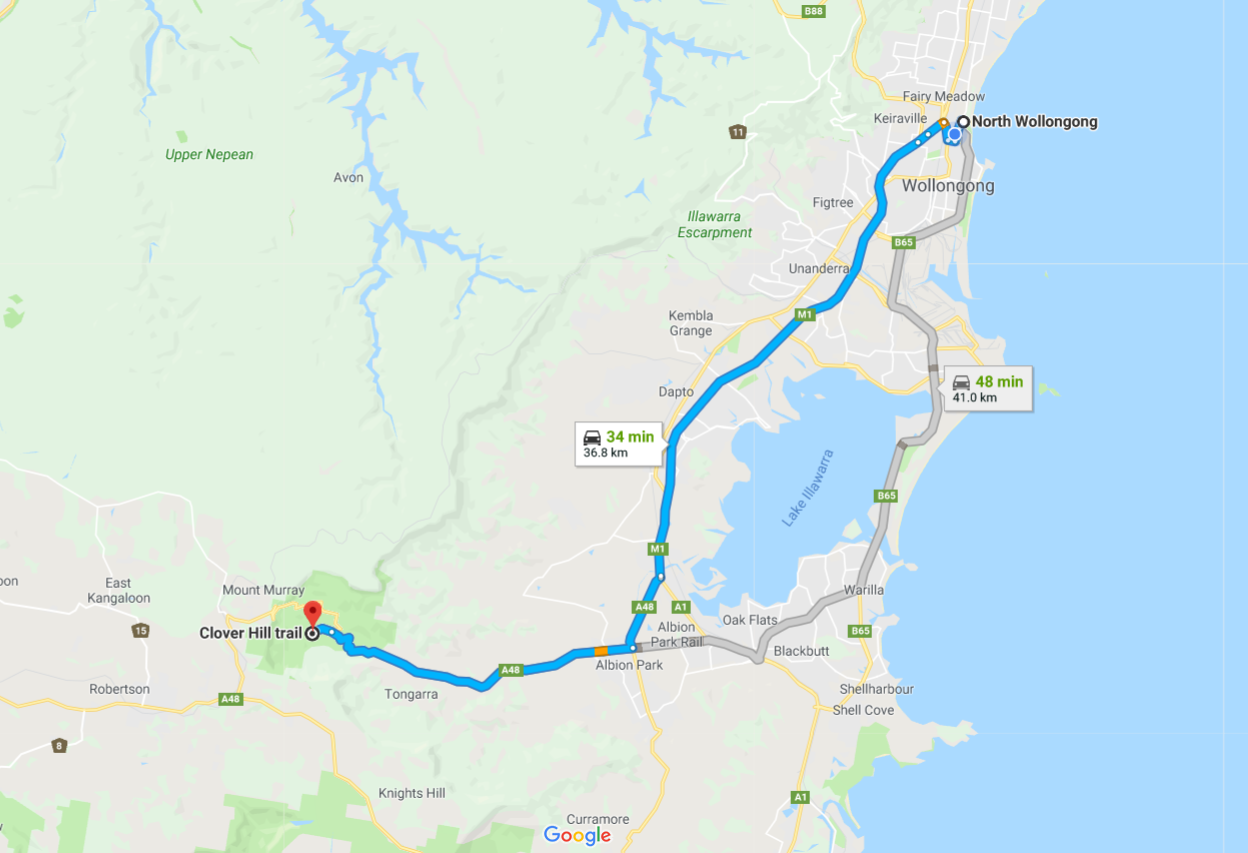
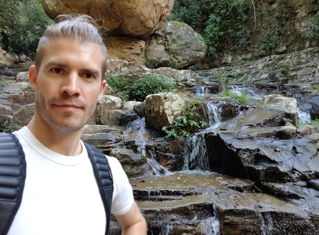
Clover Hill [Falls] Trail is a close thirty-five minute drive from where I live in North Wollongong. I’ve never been up this trail until just recently and I have to say, it is one hundred times better than I had expected.
Four waterfalls you can climb up and nobody knows about this trail. WTF?
Far from the jostling crowds of globally popular places like Yosemite or Yellowstone National Parks, lesser known trails in far less marketed places offer everything a nature lover wants to experience. Peace and quiet, and if possible, the absence of other people.
If I wanted to be shoulder-barged by inconsiderate jerks and then abused for their own lack of spacial awareness, I’ll go back to Miranda Fair. Apparently, even the drivers there are clueless.
Cross the threshold and into the rainforest.
As I pulled into the carpark, which is only just off the Illawarra Highway, I had a pretty good feeling about the place. The parking allocation was tiny. If everyone squeeze in tightly, you might fit ten or twelve cars. And there was no overflow carpark. There were three cars parked when I arrived.
I padded across the threshold of the trail head and onto Clover Hill Road. I was speaking with a shady-looking biker, with a pleasant demeanour on my way back out who explained that just twelve months ago, the gates were opened for car access. You have no idea how glad I am that they closed it off. It eliminates petrol fumes, noise and lazy (and often irritating) tourists from spoiling a somewhat hidden place for those of us who like to remain solitary during our walks.
Tranquillity allows you to dwell on all those who’ve wronged you.
If you’re a part of a minority group, had a shit upbringing or just a bad working week, chances are you’ve got a lot on your mind that needs addressing. Doctors and therapists recommend outdoor activities and a bit of physical exertion to promote good mental health, but being alone in the woods near cliffs and fast moving water may not be your best option. If you’re reading this on your way out to the trail, don’t turn around now. Who knows? Maybe the canyon at the first waterfall, Rainbow Falls will snap you into a realisation that the one life you have is pretty damn precious.
You’ll spend approximately an hour or so walking the three kilometres getting to the last of the waterfalls, Clover Hill Falls. The majority of the trail is an old logging road/ fire trail (that until recently, was accessible by car). It’s basically the width of a car and free of large obstacles. Between the leaf litter under foot and the regular activity of hikers, no weeds pop through, that is until you get to a section, which has far greater sunlight exposure, and only tyre tracks on either side of a central median remain weedless. Peripheral greenery that sneaks across is either snapped off or brushed back into the median as you walk past.
Y'all have reached the dairy!
You’ll arrive at a clearing after fifteen or twenty minutes walking and notice the tall cabbage tree palms swooshing in the wind above you in the near distance. You’ve reached the clearing that was transformed and farmed by Europeans over one-hundred years ago. I’ve read it was a dairy farm, but actual evidence [blogs don't count] of that remains scant. While I didn’t sit down there myself, it would have been nice to take a right at the fork to explore further and brew up a Trangia tea.
Bring a hammock, a book and chill out for an hour (after you get to the falls).
The last time I asked a ranger at a campground whether I was able to use my low-impact Hennessy hammock, they considered it for just a moment and flat out refused it. I decided that was the last time I was going to ask permission for something I should be allowed to do. The manufacturers of the hammock designed it so that it can be lashed gently around supporting trees by the use of wide webbing straps to distribute the pressure evenly over a large surface area against the trunk. I’m a freaking environmentalist at heart (one of the strongest reasons to go vegan), so it annoys me when misinformed rangers assert authority over park users following best practice. What’s even worse are the allowances for shooters and fishers to kill native wildlife, such as kangaroos while low-impact hammocks are a no-no. It’s just the stuff of mental angst, right?
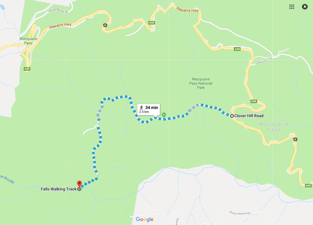
This map really means nothing. Bring your phone to use Google Maps.
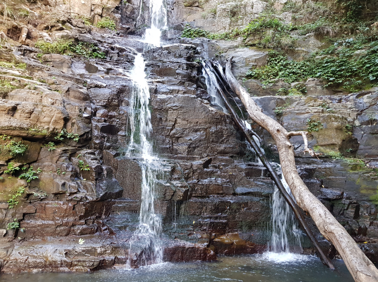
Mulangong Falls are gorgeous and often the place where visitors turn back [I'm a culprit]. Keep going. Apparently, the best falls are to come.
Why head up Clover Hill [Falls] Trail?
The short trail gives a little bit to the serious hiker short on time. The grade isn't as bad as the National Parks and Wildlife make out it is. The trail gives you FOUR beautiful falls that you can get up close to. The last time I went out to Fitzroy Falls, you couldn't look over the falls. Rainbow Falls (the first waterfall) permits it. And you might be able to watch a few canyoners abseil their way down into the rivulet below.
Following that, keep heading upstream and you’ll come across an unnamed waterfall [as far as I am aware], Mulangong Falls and lastly Clover Hill Falls, arguably the best of the falls.
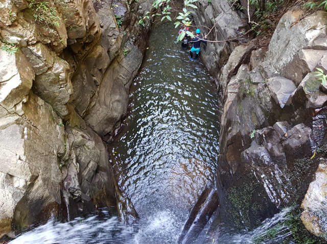
I've no idea why it is named Rainbow Falls, but I was super surprised when I came across a group of adults and children canyoning down on ropes attached to bolts on an overhanging boulder.
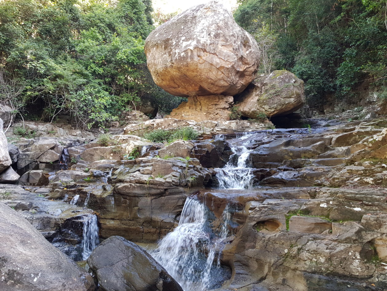
I’ve decided to name the unnamed falls, ‘Zen Stone Falls’. This is the second waterfall you'll see on the trail.
Bring toilet paper. You'll need to poop if you eat as much fibre as I do.
The trip up and back will take about two and a half hours. Take into account you’ll need extra time to eat something, stop for a pee/poop break (there aren’t toilets, so bring poop paper!) and to relax in your hammock.
See you there. I’ll be the one waving as I gently sway in my portable lounge between the eucalypts, giving the NPWS ranger the middle finger.
All the best,
Nick.
All content is original.
Disclosure: This article was not a paid promotion and was not self-upvoted. Nor were there any affiliate links.
Thank you so much for your support on my Steemit Space. Please Upvote, Comment and Follow @nickmorphew for regular content.
I do my best to engage with all thoughtful comments. This space absolutely invigorates me, so shoot me a comment.. even a critical one. I love fans and I love argumentative a-holes. I don’t discriminate.
I’m still looking for an artist to cover my work on my fantasy saga, Adventures in Elowyn Glade. Please make some noise if you’re interested.
You have a great adventure dude. So glad to read anything related to traveling issue as I'm a travelling addicted.
Anyway, Mulangong Falls seems like my favourite spot. I love to swim in the natural swimming pool. It's a challenging, since we had no idea what's in the bottom 😅
Sweet!
When did you do the walk? I'm strapped to find people nearby who are on Steemit near me!
Take care.
Nick
No I didn't go there yet. It became my favourite since I see the photograph of the falls in your blog. Hopefully I would have a chance to be there someday.
I'm currently based in Indonesia, Aceh.
Why don't you visit us later in the future.
You can find some information in my blog. You can check it out.
Take care Nick!
Congratulations, Your Post Has Been Added To The Steemit Worldmap!
Author link: http://steemitworldmap.com?author=nickmorphew
Post link: http://steemitworldmap.com?post=clover-hill-falls-trail-macquarie-pass-national-park-how-many-waterfalls-must-a-trail-overlook-to-make-it-into-the-top-20-walks
Want to have your post on the map too?