The Map is Wrong?

I'm a traveler who is heavily dependent on maps, especially street maps or my friend on the road - maps.me. For someone who has forgotten her age, names of people, or the current month, you can just imagine that sometimes I forget where I am. Yes, I get lost most of the time that I was nicknamed Dory by some friends I met during my trip.
They knew I was probably finding my way back when I was late coming back to the hostel. I told them that I made it to this part of the world on my own and that it was kind of annoying when they were checking on me. These guys just expressed their disbelief to my craziness when one night, I got really lost and had a scary argument with a Colombian police. Surprisingly, the only things I don't forget and that could save me are my languages, so I could speak three fluently. And I'm still trying to learn more, in case I forget my cellphone, or get lost again somewhere in this world.

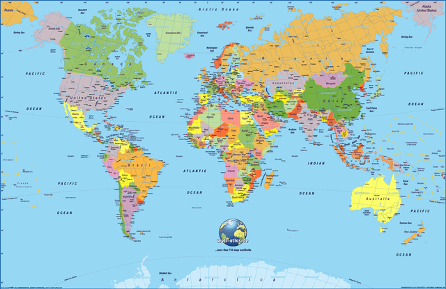
You are probably used to the good old Mercator Map here, with all those countries you look up to there. Enlarged sizes of Europe and North America, with Russia and Canada seem to appear taking up most of the Earth's landmass. And ignoring the reality of the vast Pacific ocean and other irrelevant countries in it. Don't forget to ignore my dream place Antarctica as well.
Blame it to the great Flemish geographer and cartographer Gerardus Mercator who put this massive spheroid on a 2D surface. It's tricky because the world is a sphere and a map is flat, creating visual distortions.
Take note, it is just the map that is flat.
Thanks to him, it makes it more convenient for us to look at the map, a slight cure to ignorance, for those who do not have enough geography knowledge.
I'm not a Cartography geek of some sort, I actually had forgotten my school days of studying the different map projections. By the way, Cartography is the science or practice of drawing maps.
A common question I get when I was traveling,
Where is your country located?
Here, look at the map!
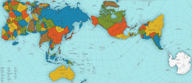
Now, what if Mercator map is wrong? There's a map called Authagraph which claims to be the most accurate map you have ever seen. Be forewarned though, you might not like what you see.

Japanese Architect Hajime Narukawa created this new map for several years to correct the distortions, now Japan is at the center of the world. I guess every map seems to have some bias.
I just couldn't accept what happened to Brazil here, China is shrunk and Africa is now bigger. And Antarctica is now part of the world map, and there's more blue around. Looking at this map is totally uncomfortable for us who have been looking at Mercator map all our lives. The Mercator map just focused on the land masses, distorted and enlarged the powerful nations. I guess it's just easier for us to ignore the reality of things for convenience.
In my opinion, if this is really the most accurate map, then I would not have a problem to reorient myself and remove this lifetime bias of looking at Mercator map. I would prefer to get used to the reality.
Does it make sense to you?
Welllll.... I still can't see the U.K.!
Either map will do me, it will take a little adjustment to get used to the 'correct' one though.
I heard a while back that land masses on maps were biased - imagine the state of the maps when we couldn't look down on ourselves!
Cool blog idea :D (vote coming soon!)
I am trying to get used to this map now lol.
Thanks as always!
Pleasure :)
Corrected the appalling mistakes above too!
Yes, 2D maps are always distorted and I don't know how much better the Authagraph map is. I'm from Switzerland and Europe is too big on the Mercator map xD
I agree about the 2D maps, I'll go check about the globe now... 😊
No flat surface can ever represent the entire Earth without "distortions". It is simply a mathematical fact. If you want a distortion-less map of a world, get a globe.

Sure, I'll bring a globe wherever I go lol. 👏
Hahha, the globe is still wrong.
P.s: The form of the world is a geoid.
Thank you @jbp! 😎
I'm happy because there is an internet conversation happening about maps which doesn't involve arguing about the Earth being flat or a spheroid, an argument which is getting a bit popular somehow.
now you jinxed it. someone will say it's flat now. 😉
Hahaha, I hope they are not arguing about that on steemit, are they? lol
Yes. I have seen them and even engaged in trying to convince them of our almost spher perspective.
Google Earth is the digital analog of a globe. Seriously though, do you ever need a world map when you're not at home planning a long trip? I suppose for schooling they need world maps at school and taking tablets might not be a safe option but apart from that
I want to know where I am in this world....
Do you know about: http://thetruesize.com ?
The True Size Of ...
"Drag and drop countries around the map to compare their relative size. Is Greenland really as big as all of Africa? You may be surprised at what you find!"
Wow I love this site thanks! It's quite fun, Greenland is small lol.
mindblown
@diabolika
Very nice post...thanks for sharing this info
You know Indonesian.
This my country.
Hehe
Thanks for sharing
No worries! 😎
Hehehe
This post has received a 0.52 % upvote from @drotto thanks to: @banjo.
My country is Romania, a fairly small country in Europe. But I found it on the map, it looks good
Good that you found it on the map.
Yes, yes :D
always good to see a different map. changes the view a little bit. great post thanks
No worries!
Russia doesn't look big enough, don't they have 12 or 13 time zones? That would make it 3x the size of the continental US, which it isn't portrayed as.
Yeah, and US is small now on the new map.
I think that the map creator likes crack, maybe a Dali enthusiast.