MANALI TO LEH LADHAK ROAD TRIP
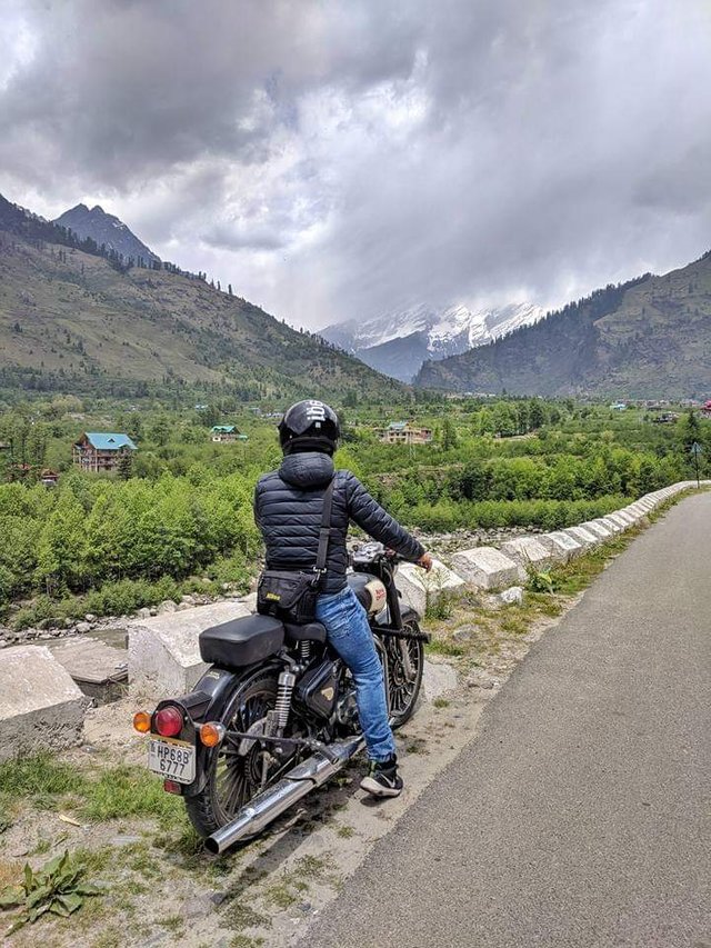
The Leh-Manali Highway is a high mountain road situated in India. It spans over a length of 479 km (298 mi) among the Himalaya mountain range. It passes through some of the world’s highest mountain passes in the world, with a mean altitude in between 2 to 3 miles above sea level. Uncertain weather, high altitude, extreme cold and no civilization for miles make this a very treacherous track. Carry extra fuel and feel close to heaven.
This road connects Leh in Ladakh in Jammu and Kashmir state and Manali in Himachal Pradesh state. It crosses some of world’s highest passes including averaging well over 17,000 feet. The journey from Manali to Leh takes about one full day by jeep or two days by bus. It’s accessible for cars and trucks during several months in summer only and its highest elevation is 5,328 m (17,480 ft) at Taglang La mountain pass. Because of the important position of Ladakh between China and Pakistan this Highway plays an important strategic role for India, which results in the maintenance of the road by the Indian army itself. In addition to the spectacular landscape the life on and next to the road is diversified because of a wide variety of people frequenting it. Construction workers from other parts of India are working for better road conditions during the summer.
This road is usually is open for only about four and a half months in a year in summer between May or June, when the snow is cleared by the Border Roads Organisation of Indian army, and mid-October when snowfall again blocks it. Avalanches and heavy snowfalls can sometimes block some sections of the road and can be extremely dangerous due to frequent patches of ice. Conditions can change quickly and be harsh. Road closures can be frequent, so check conditions before traveling to this area. Tourists from all over the world, as well as a growing number of Indian tourists use this road for the scenic impressions of the mountains. Truck drivers transport their cargo to Leh and back to other parts of India.
It is part of the National Highway 3. The trip on this road includes a lot of dangers. The road itself, with trucks and buses that sometimes travel only at 15 to 20 km/h due to the road condition. This is not the most comfortable drive in the world. This is not helped by the fact that some of the roads have drops to the side of a good few hundred metres. You can observe crashed and unlucky vehicles cover with rust down the slope somewhere… And some of the passes are really spectacular, especially if you have to wait on the side of the road for a truck to pass… The road is one of the most complicated and challenging roads in the world, with snow, never ending traffic jams, landslides and terrain making the journey exceedingly difficult.
Geographical Features
The average elevation of Leh-Manali highway is more than 4,000 m (13,000 feet) and its highest elevation is 5,328 m (17,480 ft) at Tanglang La mountain pass. It is flanked by mountain ranges on both sides featuring some stunning sand and rock natural formations.
The highway crosses many small streams of ice-cold water from snow-capped mountains and glacial melts without a bridge and it requires driving skill to negotiate fast-flowing streams. The landscape changes immediately after getting past Rohtang Pass and entering into Chandra river valley in Lahaul region that lies in rain-shadow. The greenery on the southern side of the mountain pass disappears and the mountain slopes on the leeward side become brown and arid. However, the mountain peaks are covered in snow and shine brightly in sun.
Leh-Manali highway is generally two lanes wide (one lane in either direction) without a road-divider but has only one or one and a half lanes at some stretches. It has over a dozen bailey bridges and most of them are in dilapidated condition. The highway has many damaged stretches and under-maintenance portions where even a little rainfall can trigger landslide making it very dangerous to cross that stretch of the road. The riding quality is not good at many places and fast speeds can cause discomfort.
Important things to keep in mind on the Leh Manali highway
Stay hydrated. Yes, there are very few toilets on the Leh Manali highway. At many places, you will have to “go in the open”. But don’t skimp on drinking water for the fear of wanting to go to the loo.
Stay warm. Hands and feet can go numb, which is a bad idea at these altitudes. You can use these hand warmers and body warmers to stay warm. Keep a light sweater, a windcheater and a woollen cap to cover the ears handy.
You will find shared SUVs leaving for Manali from Leh. These boast of “doing” the Leh Manali highway in a day. This means a continuous drive of 16-18 hours for the driver. This also means crossing the Rohtang Pass (or some mountain pass) in the night. It means a cramped SUV and all of this means high risk and a miserable time. Attempting to do this, especially when you are a tourist to Ladakh is one of the most foolish things to do.
Best time to travel
The Leh Manali highway is usually open for traffic from June to November. The exact opening and closing dates depend on the weather condition and the amount of snow on the mountain passes. This year, in 2018, for example, the road from Leh to Manali opened at a record early date, in the month of May itself. This is because of extremely low levels of snowfall the previous winter.
The closing date will also depend on the weather conditions towards the end of the summer of 2019.
Having said that, the best time to travel is from mid-June to September. By late Septemeber/October many of the <emdhabas< em=””>and campsites along the Leh Manali highway start shutting down. People who set these up, start going back to their villages.
By October, it starts to get cold on the high mountain passes of the highway.
Manali Leh Highway Route
Below is a detailed description of the route that you will be taking from Manali to Leh.
Manali – Marhi – Rohtang Pass
Your first day of the journey from Manali will have you cross the mighty Rohtang Pass. The biggest concern when it comes to crossing Rohtang is that of a permit without which you will not be allowed to travel towards the pass. This can be obtained from either Manali SDM office or online. Please read through the articles below in order to get more information on what the Rohtang Pass restrictions are and how you can get a permit to cross over.
Manali – Leh Highway: Ladakh by Road
Out of the two highways which lead to Leh- Ladakh, one is Manali- Leh Highway, the perfect road for adventure enthusiasts, the other one being Srinagar – Leh Highway. This highway is 464 km long, out of which 350 km, does not have any civilization. For 365 km on this highway, there is no fuel pump as well. Thus, traveling on this highway needs proper amount of planning.
It is anytime better that that you should try Leh to Manali instead of Manali to Leh. The main reason for this is, you are already comfortable to such high altitudes, moving downwards will not be much of a problem.
You can halt at Sarchu, which is at an equal distance from both the destinations. It is a beautiful place and has numerous accommodation options too. If you do the other way round, day 1 will be Manali – Keylong and day 2 will be Keylong to Leh. Since Sarchu is placed on high altitude, it is not advisable to have a nigh halt here.
But at the end, it depends on the traveler, whatever he feels comfortable with. This highway also offers a beautiful journey.
Things to Carry for your Car or Motorcycle
If you are traveling by your own motorcycle or car, then you will need to get it prepare for the tough trip ahead. You will also need to carry some essential tools and spares to ensure a hassle free trip. I have covered these two aspects in two different articles that provide information on how you can prepare your motorcycles and some tools / spares that you must carry. Please take a look at the articles at the link below. Items mentioned in these two articles will be in addition to the list I provided above.
Medicines
Diamox works as a precautionary measure (not a cure) for acute mountain sickness but please ensure that you are not allergic to sulfur medicines. Best would be to consult a doctor if you are unsure. Apart from Diamox, carry some other basic medicines for headache, upset stomach, fever, cold and cough.
If possible, I will also recommend carrying a small pack of glucose. If the high altitude, long hours of travel and mountain sickness start to take a toll, it can work miracles to keep you going; providing instant energy. In all probability, AMS is bound to kill your appetite as well and some glucose will definitely come to rescue in such a situation.
Electronics
Chargers of all your electronic devices
Spare Battery for your camera if you are into photography
Power Bank if you plan to use your phone camera a lot. Batteries die faster than regular rate in cold environment.
Car Charger will be a good idea if you are traveling by your own car or renting a private taxi
Spare memory cards if you are a trigger happy person clicking pictures at every turn
Documents
At least one government issued identity card like driver’s license, voter ID, Passport or Aadhar Card. Please ensure that you are carrying both the original and a few photocopies of it.
Print out of your itinerary
Copies of your flight tickets if traveling by air
Hotel reservation slips if booked in advance
Write down some of your emergency contacts (name and phone numbers) on a piece of paper and keep it in your wallet. I am not talking about saving it as emergency contact in your phone; but to actually write on a paper.
Medical insurance if any
Multiple copies of your Inner line permit once you have procured it in Leh
Passport size photographs.
Congratulations @dheeraj777! You have completed the following achievement on the Steem blockchain and have been rewarded with new badge(s) :
You can view your badges on your Steem Board and compare to others on the Steem Ranking
If you no longer want to receive notifications, reply to this comment with the word
STOPTo support your work, I also upvoted your post!
Do not miss the last post from @steemitboard:
Congratulations! Your post has been selected as a daily Steemit truffle! It is listed on rank 24 of all contributions awarded today. You can find the TOP DAILY TRUFFLE PICKS HERE.
I upvoted your contribution because to my mind your post is at least 4 SBD worth and should receive 163 votes. It's now up to the lovely Steemit community to make this come true.
I am
TrufflePig, an Artificial Intelligence Bot that helps minnows and content curators using Machine Learning. If you are curious how I select content, you can find an explanation here!Have a nice day and sincerely yours,

TrufflePig