Cool things we do with Satellites #6 : Near real-time detecting of oil spills worldwide
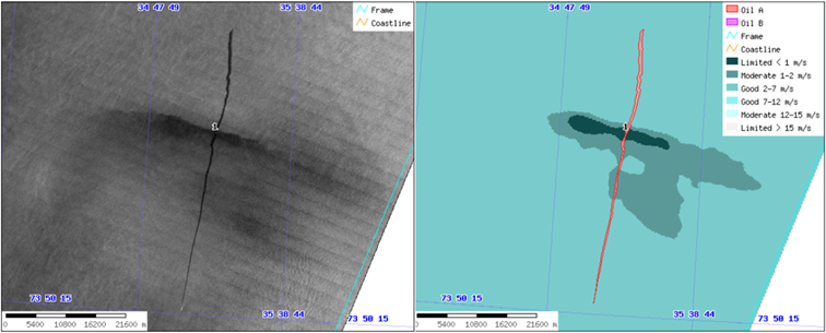
Satellites can help provide near-real time monitoring and reporting of oil spills
Image credit: KSAT - Kongsberg Satellite Services image source
Oil spills can do serious damage to marine biology, the environment and also to coastal recreational areas. Detecting them and acting quickly to minimize their damage is therefore of vital importance to numerous stakeholders as well as to the public at large.
However, with oceans covering 71% of the globe and with thousands of vessels travelling different routes at any given time as well as numerous oil-rigs, keeping track of all potential areas for spills, as well as noticing and reporting them quickly is a big task.
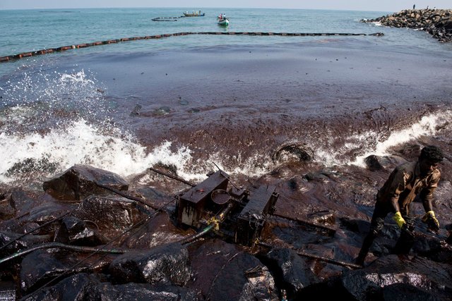
Oil spills can cause significant damage to coastal environments, like what happened on February 2017 on the Bharathi Nagar Beach coastline in Chennai, India
Image source
However, there's a satellite app for that!
Satellites provide two unique benefits to solve the problem. First, and most obviously, they provide global coverage, allowing for every corner of the globe to be monitored. Indeed, for most regions of the oceans, there would be nothing else to observe and detect a spill outside of the ship itself. Second, the radar satellites using SAR (Synthetic Aperture Radar) are able to see through clouds. This means that a detection service can work at any place on Earth 24 hours per day regardless of weather conditions.
So how does it work?
Radar images do not display colours, however, they can show dark spots in an otherwise lighter environment. This is due to the fact that oil spills affect the scattering of electromagnetic waves which in turns changes the roughness of the sea surface. This tiny difference is noticed by the radar which is sensitive to millimetre changes. With a constellation of satellites frequently providing new data from any points on the ground, every day, for more than 20 years, prediction models has grown increasingly good at distinguishing oil spills from other dark spots in the oceans.
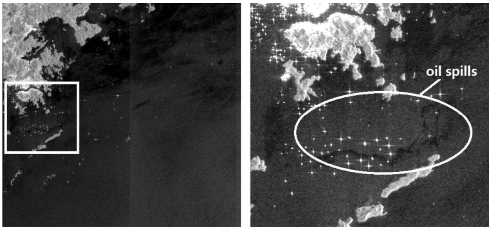
Detected oil spill in the Hong Kong coastal region from an ENVISAT ASAR image
image source
However, it can still be difficult to distinguish between other naturally occurring dark spots with similar characteristics from oil spills. Therefore, relying completely on the satellite images may help you find the oil spills, but it also finds a lot of extra false alarms.
Adding GPS data and SatCom
As it happens, it is mandatory for large trading vessels to use an Automatic Information System (AIS), the maritime equivalent of air traffic control that allows for autonomous tracking of ships. This system reports the position, moving direction and speed of the vessel and was initially built to prevent collisions. Since this data is obtained by the same coastal guards who need information about the occurrences of oil spills, this information is added to the oil spill monitoring system. If a dark spot resembling an oil spill is detected, it will quickly check if a vessel has recently passed over the same area, increasing the likelihood of it indeed being an oil spill.
This is now also done with satellites, as it was previously impossible to continuously track all ships all over the world due to the world's curvature meaning that ships travelling more than 72 kilometres apart would lose their connection. In fact, in my home country Norway we launched our own AIS satellites to provide better coverage in polar orbits. This has provided the coastal guards with complete communication links in the northern regions, and also helps make ship traffic for offshore oil platforms more secure.
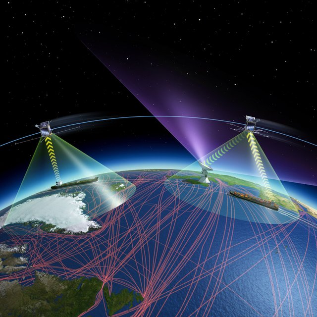
Illustration of the AIS satellite network in Northern regions
image credit: ESA image source
Thus, the monitoring, detection and reporting of oil spills actually use all three main categories of satellites: Earth Observation (EO) satellites, global navigation satellite systems (GNSS) and communications satellites (SatCom). To me, it is a very cool example of technology and data integration to provide a unique tool that would be impossible to make with the same level of precision and continuity without the use of space-based assets.

Want to discover more science and technology related content on Steemit? Follow @steemSTEM to see a weekly selection of quality science posts, as well as STEM-related contests. Are you interested in writing posts on related topics yourself? Make sure to join the steemSTEM channel on steemit.chat or Discord to engage with other scientists on steemit!
As always, take care and steem on!
This was really cool, and informative. I love learning about things I would never have found on my own save for a random rabbit-hole like Steemit, or Reddit, etc. You click on one link and find yourself learning about oil spills being detected by sattelite imaging, cool.
This makes me think about AI and its ability to process and comprehend the stream of data that the satelites collect. I assume the dark spots (the oil) isnt being obsevered by some human watching the many, many, many satelite feeds? Presumably, AI does that? AI's ability to look at a picture and understand it, and convey that meaning in a helpful manner is so intriguing!
You may not know this, but one of the ways AI "learns" to better identify what its observing in visual feeds like the satelite images, is by asking humans what we see in those same images. I was surprised to learn, when I log into a website and it asks me to confirm that I am not a robot, and then asks me to click on the specific portions of a picture which are, a street sign or an automobile, or whatever... those are actually data collectors which use our human selections as tests against the accuracy of the bots they are training to do that type of data sorting.
Cool, no?
Love to read comments like these! Great to hear that I have been able to reach someone with something they didn't know :)
Humans certainly make the final call, but AI help provide the humans with a more reasonable amount of images to look into.
Wow my friend @fredrikaa this information is very good and informative, I work in the Venezuelan oil industry but on land, here we still do not have that radar technology, however we can see the spills through well checkers or by the same staff. In the world there have been large oil spills such as the one that originated the oil platform deepwather horizon in 2010, it has been one of the biggest spills, which by the way the movie that tells the story is very good! We must preserve our environment and be attentive to any oil spill, very good satellite technology. Thanks for this information my brother. Regards..!
The radar images from the European Sentinel 1 Satellites is freely available for anyone to use and also gives maps of Venezuela. You can actually access it yourself and use it for free here, so now you just need someone who knows to work with the data :P.
But if you want frequent updates or close monitoring of a particular area, then you will need commercial data.
I think it's great, now from my pc I will enter, the truth is that it is a good technology and it serves as a great help for the oil world, not only to observe oil spills but also for any additional information that is needed. Thank you so much, my dear friend! It is good to always learn new things and to stand by technology!
Indeed you are right @infidel1258, application of AI into this field will be of great help, especially using image processing to discover patterns and change of the sea along oil rig.
Is this already implemented? I mean, once a spill is detected, do we have teams somewhere around the globe that could clean it up (on top of warning the boat)?
It certainly is. The technique has even been used for more than 20 years, and a common service in Norwegian Oil and Gas activities for at least 15.
Allowing it to be near real-time is, of course, dependent on the number of satellites you have access to, as the imaging satellites are in low earth or polar orbits and thus not fixated over the same point, meaning you will have to wait for a revisit to get an update. This has become more accessible in the last 3-5 years with the European Copernicus satellites as well as TerraSAR and other commercial satellites.
Literally all images captured by these satellites that are obtained are scanned for signs of spills. However, if there is a big crisis like in the Mexico Gulf, you would rather execute an order to have satellites point directly to the spot and not have to wait for a new revisit of another satellite.
Thanks a lot for taking the time for drafting this answer! This is very kind from you!
Hi, I found some acronyms/abbreviations in this post. This is how they expand:
Whoa!! Nice post! I routinely work with AIS data, let me know if I can be of any help! 👌😅
Thanks for the nice feedback!
Well, I'm sure you could either work with the service providers such as KSAT to help improve their service or with the emergency response units to help them make better use of it. :)
I will look for the research groups involved. Thanks! 🖖
Hey @fredrikaa, great post. Do you know if satellites are able to penetrate beneath the ocean? Ya know...to track those Russian submarines up north.
Also, your description of AIS made me wonder how the US Navy has managed to be part of several collisions over the last year even with this tech. Any ideas?
Ryan
Yes, we can see beneath the water to find subsea mountains and map the formation of the ocean floor. No we cannot detect submarines, yet!
Large trading vessels have to have a AIS beacon. However, their positioning then becomes public information and is shared between all ships, coastal guards etc. Military, like those US ships, will obviously not have it as it would simply give away their location.
Okay Fredrik.. I now have to look up the other parts. I did not expect this application at all! It prevents so many powerful companies to cover up their big leaks when applied right! Lovely read mate
t.
It can do a lot more than you would think :) the precision at which SAR satellites can detect changes are quite impressive. glad you liked it!
I knew that about aerial photography which a befriended pilot use to tell me about...
But I wasn't expecting that these tremendously distant "cameras" to be able to do the same. I kind of took the movie references of them to be how CIA get to "enhance" security camera video, which suddenly enables them to read a numberplate of 100m away, etc.
Great to see they did get it more straight in regards to satellites.
t.
I don't think of satellites as cameras, more as sensors. We get information beyond what the human eye can see from parts of the electromagnetic spectrum that our eyes are not sensitive to. So we can discover a lot that we would not be able to see otherwise.
That where the " " were for! ^^
Tnx for responding Fredrik!
t.
It is necessary to apply this technology to safeguard our environment, unfortunately in my country (Venezuela) because of the poor condition of the pipes and equipment, oil spills are very common and do not come out into the open, creating serious environmental damage.
It's amazing. I can't believe there are still people who think we should be de-funding research in space-related endeavors.
I write astronomy and technology writings on my profile. For now I am only writing in Turkish, but in the future I will also translate my texts into English. If you support me, you will make me happy. :)
Paylaşımınızı çok beğendim, bende profilimde astronomi ve teknoloji yazıları yazıyorum. Şimdilik sadece Türkçe yazıyorum fakat gelecekte yazılarımı İngilizce'ye de çevireceğim. Profilime destek olursanız beni mutlu edersiniz :) .
That's really cool! Happy to see more people here who love astronomy :)
Great information for us
Thanks for the sharing sir
Resteem your post
Thanks for that :) glad to hear that you liked it!