ULTIMATE NAVIGATION PART 3: NEIGHBOURHOOD NAVIGATION PACE - MOUNTAIN TRAINING
IN PART 3 OF OUR JEDI HILL SKILLS TRAINING, NAVIGATE WITH @MATTHEWSHAW TAKES YOU INTO YOUR LOCAL ’HOOD.
"Designed to help improve your navigation, using techniques and tools you can safely practice inside your home, then your garden, and in this module we take you into your local neighborhood - don’t worry we’ll be on the hill soon!"

PACING
Pacing is a very straightforward yet highly effective technique that’s in my top 10 navigational ‘must haves’! To do it all you need to know is your personal pace count – how many paces it takes you to walk 100m – because knowing this, you can easily calculate how far you have walked.
Select a level piece of ground (it can be the street outside your house, a local sports field, football pitch or municipal park) and measure out 100m in a straight line. If you have a known-length climbing rope use this; if not, measure out 10m of string.
Mark your starting point, then lay out the string ten times to determine your 100m point and mark this.
From here, walk at your normal pace back to the start and count your ‘double steps’. If you start by putting your left leg forward first, count every step of your right foot only; this is a double step and it counts as one pace.
When you reach the start, make a note of this number.
Now repeat this exercise by walking back to where you came from, again counting the number of paces it takes you to cover the distance.
Keep doing this until you consistently get the same number – this is your personal pace count. (Typically this varies from 55 for very tall people to 75 for folk with shorter legs.)
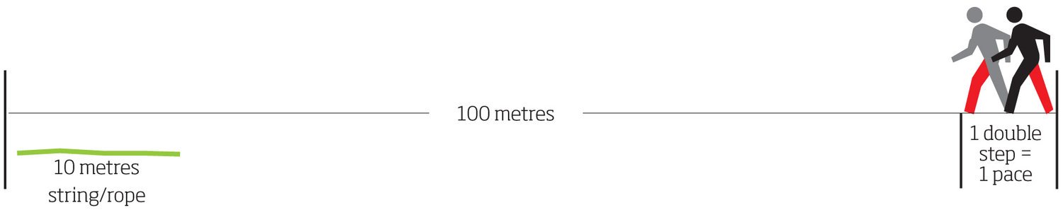
Now you know your own pace count, you can predict how many paces you will need to cover, for example, 200m. Start walking, and when you reach your pace count number you’ve covered 100m. Then start counting from zero again, and when you reach your pace count again this time you’ll have walked 200m in total. It therefore follows that if you want to cover 50m, just walk half of your pace count.
For short distances it’s easy to remember how many times you have walked 100m, but if you are wanting to measure say 500m it is easy to get confused. To remedy this, pick up five little stones; every time you reach your pace count, drop one stone and start to count from zero again. When you have dropped your last stone you have travelled 500m.

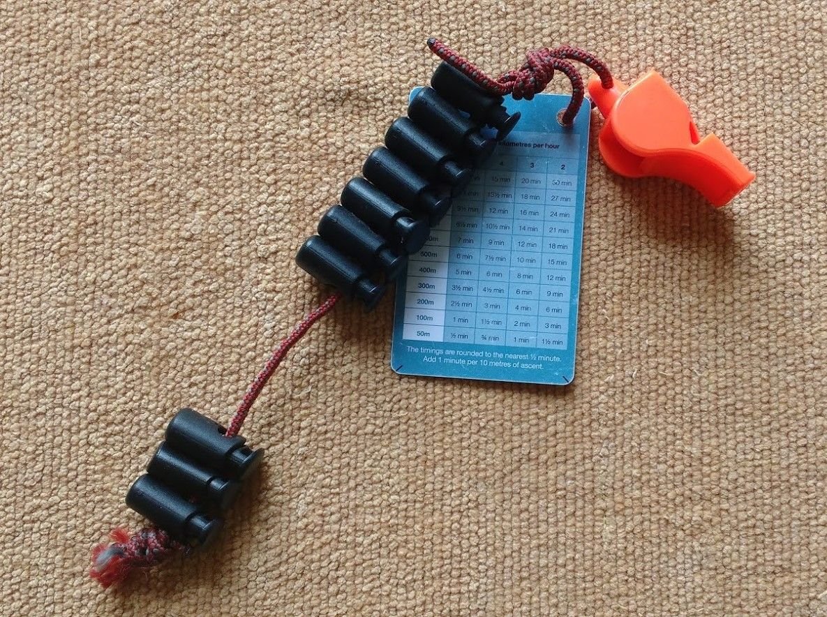
A better alternative to pebbles is to make a ‘tally counter’. Put ten toggles on a length of paracord, attach them to your rucksack, and move one down for every 100m covered.
Our personal pace count is remarkably consistent across most terrain, and while it can increase – as in you take more steps (it never decreases) – it does not do so by a large amount. You just need to be aware of this when:
a. Moving up a slope
b. in a headwind
c. crossing sand, gravel, mud, snow or heavy undergrowth
d. walking in snow or ice
e. carrying a heavy rucksack and wearing boots with poor traction
f. in poor visibility, either in bad weather or at night
g. you are tired
TIMING
Timing requires less concentration than pacing and is easier to use, especially over long distances. However, when these two techniques are used together they are a brilliant set of navigational skills and can be a lifesaver in poor visibility. Knowing how fast you are walking and relating this to a ‘timing card’ is the key to this technique.

Looking at the table above, walking on a level, grassy surface for an hour without stopping, you will cover 5km. Thus in half an hour 2.5km, in quarter of an hour 1.25km, and every minute 83.3m. For shorter distances the calculations can be tricky, so to make this easy below is a table that you can print out and carry with you:
.jpg)
From the timing card, let’s say you want to cover 500m to your next attack point and your walking speed is 4kph. Simply check your watch, set off, and stop when you have been walking for 7min 30sec.
Similarly, to cover 750m at 4kph, walk for 11min 45sec (500m = 7min 30sec + 200m = 3min + 50m = 45sec).
However, your speed can vary; again, the calculations have been done for you to cut out and keep:

You can buy a handy plastic credit card-sized version too or print and laminate.
An easy way to get to know your different walking speeds is to record and monitor your walks either using a hand-held GPS or download an app such as Viewranger to your smartphone.

ULTIMATE NAVIGATION MODULES
CLICK HERE PART 1:
ARMCHAIR NAVIGATION - MOUNTAIN TRAINING - ULTIMATE NAVIGATION

CLICK HERE PART 2:
BACKYARD NAVIGATION - MOUNTAIN TRAINING - ULTIMATE NAVIGATION

5 STAR RECOMMENDATIONS
SPECIALIZED HEADLAMPS PETZL Buy Now Amazon!
For specialized activities such as caving, orienteering, cycling or hunting and fishing, the lighting needs are very specific.

PART 4 - COMING SOON - PLEASE UPVOTE AND FOLLOW
follow please y dv
I'm not sure what y dv is?