HYDRAULIC WORKS, HISTORY, IMPORTANCE AND INTERESTING DATA
Since ancient times, human beings have seen the need to take full advantage of the water resources that have been available to them, in order to be able to supply themselves in the development of different types of primordial activities, such as the settlement of populations in certain geographical areas. areas, where undoubtedly required the execution of jobs for the livelihood of the inhabitants, such as agriculture, livestock and mining. In this sense, it is important to note that in this context, many works were constructed whose objectives were not only the capture and use of the aforementioned resources, but a part of them was built with the function of providing adequate drainage in an area determined at the time of any storm.
Among these types of works are:
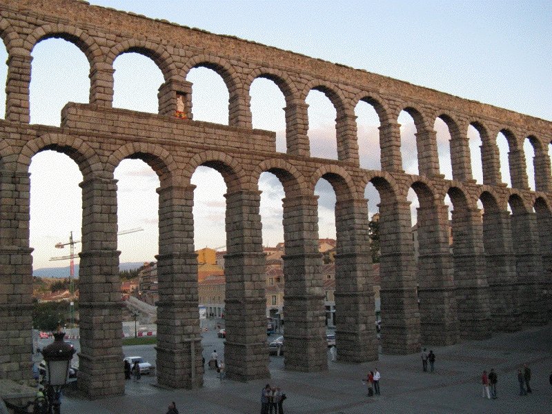
The aqueduct of Segovia, Spain, was built according to historical records, at the beginning of the second century after Christ, this imposing work like others of similar characteristics, formed part of structures designed by the Romans, whose purpose was the transport of Water flow from the point of capture of the liquid to various sectors of a populated center, running on land of variable topography. The images correspond to the aqueduct located on a busy street of Segovia, it should be noted, that in the year 1985 was declared by the UNESCO next to the old zone of the city, like historical patrimony of the humanity.

The Gard Bridge, located in the village of Remoulins in the south of France, is 275 meters long and 49 meters high, was built in the 1st century after Christ, and part of the ancient aqueduct of Nimes.


The cisterns, are hydraulic structures built below the surface that allow the capture and storage of water, had the objective of supplying depending on their capacity, a nearby urban area or territories where the agriculture, livestock or other activities. At present, the design of these structures has varied according to the type of soil, construction material and the required capacity, suppressing in most cases, the construction of porches inside the cistern. In considerable parts of the planet, they are known as underground tanks. The image shows the cistern of Theodosius in Constantinople, Turkey and the second, the cistern of Fuentealbilla in Spain.
Based on the above, it can be defined to hydraulic works as all those structures formed by a variable number of elements, which have the objective of having or exert a control on a certain fluid in order to generate a Benefit to a collectivity, either by providing protection against floods, supplying the population with water service, generation of electric power through hydroelectric plants, among others.
With the course of time and in the context of the emergence of new needs, the implementation of new techniques and technologies in the planning and execution of these projects has proved indispensable, with the unquestionable aim of obtaining more efficiency and for To allow a harmony between the development and the sustainability of the environment. This innovation has been made present, in the use of new building materials, process automation, in the physical characteristics of the structures, and in the purposes for which they are built, where not only is it limited to the supply and Security, but also includes sports.
Emphasizing the sustainability of the environment, from about the nineteenth century, when modern environmental engineering began to be used in projects to improve the quality of life, has been focused, in thoroughly investigating the development of all Hydraulic projects, being these causes in certain occasions of ecological damage in several regions of the planet. With regard to this, various institutions and government agencies have formulated a significant number of regulations that can directly alter or vary the original approach of such a work. One of the regions where there have been considerable cases of this kind is in South America, and it is not surprising or questioning that with the great geographical attributes of the region, we want to make the most of the availability of natural resources, including freshwater, and obtaining through the latter, sources of supply of the vital liquid, as well as a great electric potential through hydroelectric plants, necessary for the sustenance and development of the population in general.
However, in deepening the legal arguments that have been created, one can find the regulations of each of the ministries responsible for the preservation of the environment, the international codes or agreements that have been signed by groups of Nations (World Nature Charter, United Nations Framework Convention on Climate Change-UNFCCC) and related local and national regulations to provide protection for the fauna, flora and native populations that are based in this Territory.

Headquarters building of the European Agency for the Environment, responsible for evaluating and investigating cases of environmental damage, including when carrying out work on the implementation of infrastructure projects.

In the Organization of American States, cases have been taken on the conservation and due exploitation of the natural resources found in the different countries that are part of the American continent.
In addition to this, it is necessary to point out that the rules do not cover only the environmental but also the structural, this, with the aim of complying with the existing safety standards, to which like any other type of civil work must be submitted. These regulations are mainly focused on ensuring good quality both physical and chemical of the materials used that compose the structure, implement and evaluate the analytical methods of design that are used by the designer, encourage Drafting of manuals for the inspection of structural works, the consideration of seismic risk that is present in a specific region, the establishment of economic and penal sanctions to those responsible for breaches or incidents occurring in Facilities, among others.
On the basis of the above, the need for promoting the development of hydraulic engineering projects is notable, where the geographical conditions can be maximized, and in an integral way, provide benefits to the Collectivity in general. In this order of ideas, the challenge grows for all those who venture into engineering, to investigate in depth the innovations that can be implemented through the use of new technologies, other types of machinery, new constructive methods, among others.


The images correspond to the viaduct over the River Deba, in Bergara, Basque Country, Spain. One can appreciate the use of the constructive method used in this type of structure, which consists of placing the different parts of the board of the bridge, by means of a shoring supported on hydraulic jacks, in such a way that no greater affectation is generated in the lower area, thus avoiding temporal affectations in rivers, public spaces and roads, as shown in the photos.
In relation to the need mentioned above, it is necessary to procure from the organizations and institutions related with this area, to carry out exhaustive studies, to determine the specific solutions for each problematic one, and not to incur in the planning and in The execution of huge projects that, although they can fulfil the functions for which they are formulated, can generate negative situations, both in the urban and rural environment, because, among other things, not to consider the state in which the physical space is located That has been studied (land use).


In various regions of the world, the development of infrastructure has had a very considerable cost in the environment, among them are the deforestation, the variation of the watersheds, the destruction of ecosystems, among others. In this case, the images correspond to the satellite view and the panorama of the construction of a hydroelectric complex in one of the rivers of the Amazon in Brazil, where the alteration all the components of this ecosystem, has become present.
On the other hand, it should be pointed out that in order to obtain good results as indicated in the preceding paragraphs, it is vital that each of the states assess the need to carry out sufficient investments in this regard, since through alliances of private corporations and mixed consortiums (public and private). However, it is indispensable to have an efficient control system that is capable of determining the existence of sources of corruption that can indisputably cause damage to the projects, such as non-compliance with delivery times and disrespect to the legal regulations corresponding to the physical requirements (composition of structures and facilities), as well as to the environment in which they develop, as it is in different ecosystems rich in natural species, which in many cases, are unique in a region.


The control in the development and execution of the hydraulic projects are essential for an excellent obtaining of excellent results and to avoid the origin of problems both to the environment and to a population nucleus. Note in the images, as works of aqueduct and unfinished sewage generate damage to the inhabitants in two South American cities.
Finally, at the rate of all that has been reflected in this article, it can be concluded that the hydraulic works are extremely vital to consolidate the integral development in a certain area worldwide because, as indicated , not only are they planned for domestic and industrial purposes, but as the need and technology advance, they are part of large-scale structures used for various purposes. That is why it requires further research in the area, in order to continue contributing to the healthy innovation and planning of this type of works, respecting each of the legal bases that have been created for regulatory and protective purposes.


Views of a series of channels that are part of the California Aqueduct, you can appreciate the geometric designs adopted according to the type of terrain and slope of the same, which include curvatures of varying degrees, construction of road bridges or Railways, ponds in different places, among others. In the same way, one of the images shows a scene of the construction of a stage of this important work.

Map of the state of California, where the geographical location of the most important aqueducts in the region is reflected, it is surprising to visualize the great lengths that these channels possess, allowing the circulation of the water that is captured in the high zones Mountains of the state to several of the largest population nuclei on the West Coast and the U.S., such as Los Angeles, San Francisco and San Diego.
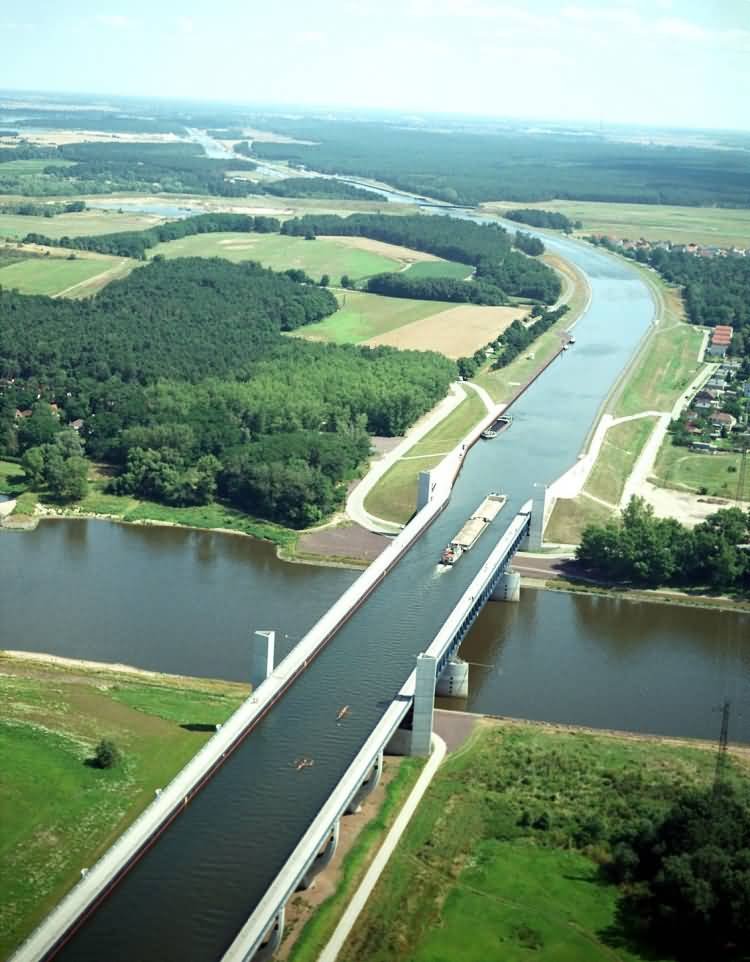


The Magdeburg aquifer bridge in Germany has been an icon for several years of the hydraulic works, this structure consists of a concrete bridge of several sections that allows the circulation of vessels considerably light by the channel that was Built, without having to cross directly the river Elbe that runs through the place, this way, it optimizes the transport in this region, emphasizing the important flow of small ships and barges that go there. On the other hand, in addition to the bridge, it can be seen through the images, as the circulation channel was designed in an area with low population density, adapting to the topography, by means of the necessary slope, the curvatures, as well as some locks.


View of a aquifer bridge in Veluwemeer, Holland, a difference in location in Magdeburg, this was built on a vehicular road, and instead of presenting an access slope to the sides, this is on the same level as the surface of the lake homonymous, while the aforementioned road has a trench passage, built on the embankment that in the foreground can be seen.


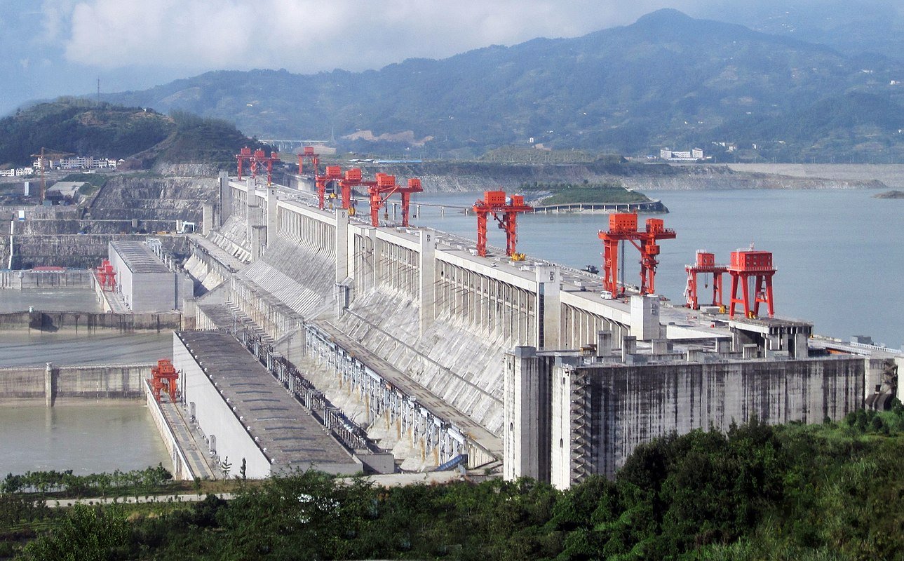

The Three Gorges Dam is an area of colossal structure on the mighty Yangtze River in China, has large reinforced concrete walls that are part of the river's water retention system, as well as an area of spillways, built on one side. This hydroelectric power plant is currently on the list as the largest dam on the planet, and has an installed capacity of 22,500 MW. In the photos you can see the previously named parts of this complex, the large proportions with respect to the height and depth of the concrete walls, also, is given to know part of the route that has the river, described as the most abundant and as one of the main arteries of river transport in China.


The Itaipu dam for a few decades, was constituted as the largest hydroelectric power plant on the planet, its strategic location in the course of the Paraná river on the border Brazil/Paraguay, has enabled the supply of energy to much of the Paraguayan territory and Important regions in Brazil. In the series of images it is observed, the colossal structure constructed of concrete, with area of spillways and of electrical generation. Because it is a very plentiful river that is born in the Amazon, the pressure of water exerted on the walls in the area of the dam is very high, so these had to be designed to be subjected to the large loads that act on them.


The emblematic Hoover Dam, located in the Midwest of the United States of America, built during the early years of the 1930, has been an icon over several decades of the hydraulic works, due among other things, to the difficult location that has the To have established itself between a steep surface in the vicinity of the canyon of Colorado, in addition the great the great height in which was built the wall of containment generates a stagnation of the water that is then liberated by means of floodgates, originating the production of Energy that is then distributed. The image also shows the road that runs through the upper part of the dam, which allows the passage of vehicles between the sides of the river.


Navigation throughout the history of mankind has allowed the development and communication of different societies through the commercial exchange made through this activity, in this context, the ports have had a fundamental role to be the Place where embarkations are carried out, loads and discharges of both goods and people. Today, many are the advances in this sector, in terms of the construction of new port areas and the implementation of technology in them, in the photos you can see the port of the city of Tianjin in China, considered one of the largest of Asia, by the dimensions of its facilities, and by the traffic of containers that are registered there. It is necessary to emphasize that for the consolidation of this maritime terminal, the construction of the springs that in the image is appreciated, the installation of various areas for the operation of shipyards and docks, the adequacy of areas of circulation Aquatic to allow the mooring of large vessels. Likewise, it highlights the terrestrial communications of the port towards the city of Tianjin the nearby Beijing and the rest of the region, having several highways and railroads, both required for the transfer of goods to and from the aforementioned terminal.


Singapore is considered to be one of the "Asian Tigers" because of the development and economy that this nation possesses. In this sense, maritime transport has the fundamental role in the sustaining and growth of commercial exchange, so that from centuries ago, the port of Singapore has been and continues to be the protagonist in this area, coupled with this, during the last decades, adaptations have been carried out in the terminal to allow the increase in the flow of goods. The images show part of the infrastructure that has been built and modernized, which together form one of the most influential ports in southeast Asia.


Recognized as one of the greatest works in the history of humanity, the Panama Canal, is an aquatic artery that allows the circulation of vessels of different draughts from the Atlantic Ocean to the Pacific Ocean and vice versa, generating a great impact on the World shipping, because through its use, it has avoided the long journey to Cape Horn in South America in order to navigate between the two oceans. Although this work is an icon in the field of engineering, its design and subsequent construction mean the need to face various problems, from the outbreak of diseases that caused death to workers and tragic accidents until the projection of the Correct elements to achieve optimal conditions in the project. At present, it continues to have the fundamental role it has since its opening, and to adapt to the conditions of a constantly modernizing shipping industry and to an accelerated trade, numerous extensions have been made to several of its components. In the series of photos, it shows in a detailed way a map of the channel, highlighting the entrances by both oceans with the systems of sluices corresponding, the zone where is the lake Gatun which in turn is obligatory step for the boats, and the location of the acquaintance bridge of the Americas on the mouth of the canal in the capital city of Panama, in the same way, we offer exact images of the system of locks used, and besides it presents a view of the longitudinal profile of the channel.


The marinas are known in the world for being a parking place for small boats of different uses and categories, from simple to luxurious. Its correct operation is related to the distribution it possesses, the number of positions available, the pedestrian and vehicular access to that area, also plays an important role the location, highlighting the freedom that boats must have to Maneuver and non interference with the trajectories of larger ships that usually occur in areas near the ports. The marina that is appreciated, is located on the Mediterranean coast, in Barcelona Spain and is named "Marina de Port Vell".


The city of Cabo Coral, located in the west of the peninsula of Florida in the United States of America, is based on a plain characteristic of this region, and taking advantage of this factor, in the interior of the urban area have built a large number of channels that they provide direct access from small boats to the owner places of residence. In this sense, the important number of complementary works that have been carried out, such as dams, drainage systems and a considerable number of vehicular bridges of different sizes. In the photos you can see an aerial view of this beautiful city, and also several sections characteristic of these channels, in this case running through residential areas.


Since the 12th century the dutch have used territories belonging to the sea, through the construction of artificial dikes that can be extended by considerable kilometers of distance and the drainage of the surface that was part of the sea. Generally, in the Netherlands and other nations, these new areas are used for the establishment of agricultural and livestock areas, considering the projection of vital elements for their proper functioning such as irrigation, energy generation electricity, a comprehensive transport network, among others. In the photos are displayed beautiful postcards of agricultural fields located in these territories, where they also stand out, a dike and an electric line formed by wind turbines, irrigation channels, a highway and a field where are cultivated the recognized Tulips.
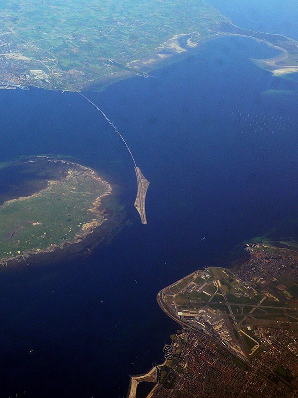


In the strait of Oresund between Denmark and Sweden, has been built an icon structure of engineering, as is the bridge of Oresund, whose main characteristic is that it does not traverse completely to the aforementioned maritime space, but is divided into three Sections, the first of them starting as submarine tunnel from the airport of Copenhagen to an artificial island built for the purpose of the project, the second section runs along the mentioned island, and finally the third stretch part of the other end of the island and It arrives to the south of the Swedish city of Malmo, by means of a bridge of reinforced concrete of type stayed, it is noteworthy that all the road structures are mixed, since it includes a highway and a railway route. A determining factor in deciding to build a bridge of these characteristics, is the location of Copenhagen airport to be seated in the waterfront, a situation that relapse in the prohibition of building structures of considerable height in the surroundings due to security measures regarding the departure and landing of the different aircraft that make use of this terminal, similarly, for economic reasons did not proceed to project a tunnel that connects both ends, but is opted for a bridge-tunnel, including the construction of the artificial island that allows the connection between these colossal structures.


The artificial islands that are found on the coast of the city of Dubai in the United Arab Emirates, are known throughout the world for the peculiar characteristics they possess in terms of their dimensions, their shape and the structures that have been built in some of the they. The construction of these islands required a good projection in which important factors such as the behavior of the tide in those areas, the quality of the materials (including the aggregates that make up the embankment and the base of the islands, the concrete according to the structures), in the same way, there were groups of workers and teams specialized in surveying, whose job was to direct and ensure that the islands were built with the dimensions and geometry with which they were designed. In the series of images, you can see the islands in front of the urban area of the city, highlighting the group that has the figure of the "world map", as well as others in which include the palm trees, in another image, is observed in many residences and hotels in one of the latter , and in another image you can see an island with a particular geometric shape.


In the city of Doha, the capital of Qatar, there have been several surface areas in the sea, similar to those found in Dubai, in the images you can see a series of artificial islands located in the coastal area of the aforementioned locality, where commercial, tourist and sporting activities are carried out, with the necessary infrastructure to communicate with the rest of the city. It should be noted, that by the type of works executed, for its construction should be taken into account, some criteria previously named in the description of the islands in Dubai.


Bibliographic:
Bibliographic resource
Thank you for your contribution. Dont forget to link references and sources when applicable!
=======================================================================================
This post was upvoted and resteemed by @Steemgridcoin with the aim of promoting discussions surrounding Gridcoin and science.
This service is free. Please follow @steemgridcoin if you want to support this initiative.
Have a nice day. :)
Wow, this is impressing amount of material! Great article, congrats!
Congratulations @johan794! You received a personal award!
You can view your badges on your Steem Board and compare to others on the Steem Ranking
Do not miss the last post from @steemitboard:
Vote for @Steemitboard as a witness to get one more award and increased upvotes!