Mt Sinabung Eruption Seen From Space
Enter WORLDVIEW Now
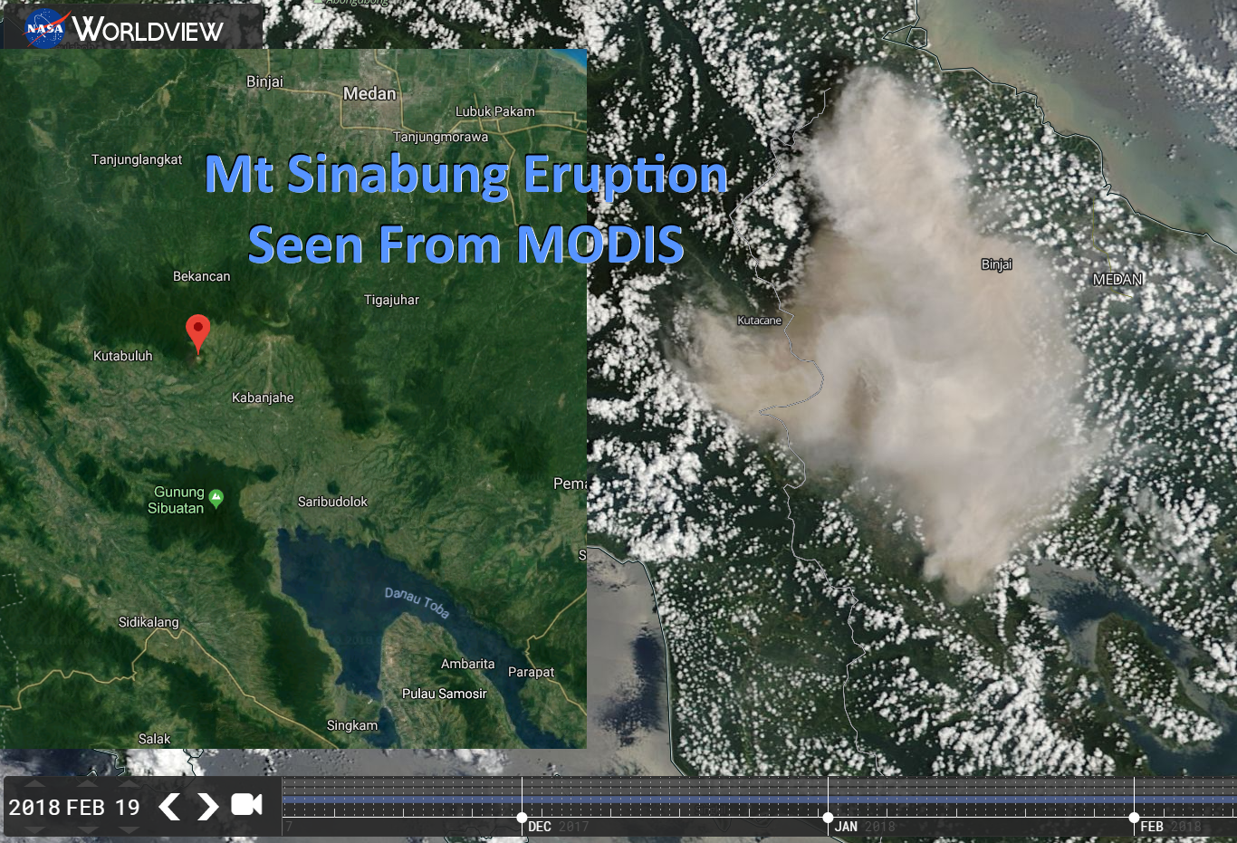
This handy tool displays each MODIS Image.
I used to have to download and overlay each image separately in Google Earth.
Some images are missing, like the one from the 20th.
NASA is probably looking at them closely.
I am.
The Eruption was caught on one nearby webcam, you can see this on Twitter.
You can download 'Global volcanic hazards and risk' here:
"An estimated 800 million people live within 100 km of an active volcano in 86 countries and
additional overseas territories worldwide"
https://steemit.com/science/@darkflame/mount-sinabung-volcano-erupts-feb-19-2018
Today, Indonesia’s Sinabung had its biggest blast in its nearly 5 years of eruptions. I reported on the initial reports of the blast and now we have some pretty stunning images from space on the eruption. It really captures the power of the blast and how the ash spread mainly to the north over Sumatra (rather than the west as predicted). Sinabung appears to have settled down since the explosion, but with this change of character, volcanologists will be looking for signs if this change will be permanent.The Terra MODIS image (below) taken not long after the eruption shows the ash column towering over the local cloud deck. The oval lake with the island in the middle to the bottom right of the image is the Toba caldera. Even in this picture, the ash plume has spread to cover over 100 kilometers of Sumatra.
Mount Sinabung in Indonesia has been erupting for about the past five years now, displacing tens of thousands as it sends debris flows toward populated areas. On Feb. 19, the volcano unleashed a far more explosive eruption that vaulted smoke and ash more than 25,000 feet into the air, prompting aviation alerts for aircraft to steer clear of the area. The eruption, which occurred on the island of North Sumatra, was caught on video by residents of Berestagi, which is about 15 miles to the west of the mountain, as well as residents of towns further away. Areas under the ash cloud saw the sky turn from day into night, while a layer of volcanic dust fell onto the ground.
Nice photo..

@magoo-1 always on duty.
Hlw author this guy owner multi ID and always comment by multi ID.This person always try to chest and get your reward.
You can check report
https://steemit.com/magoo-1/@magoo-1/comment-thief-and-spammer-report-1.
Great Work @darkflam

Thanks for sharing!