Where Eagles Fly : Taos to Winslow ~ Part 3 ~ Jicarilla Apache Badlands to Chacra Mesa Anasazi Lands
This is the 3rd post in a 5 post series based on an aerial exploration from Taos, New Mexico, across the desert to Winslow, Arizona over some very interesting and unusual wilderness.
Continued from Part 2...
Looking at the full frame version of this photograph of Huerfano Mountain which ended the past post you can see at the bottom of the picture an area known as the Badland Hills, part of the First Nations Jicarilla Apache Tribal Reservation.
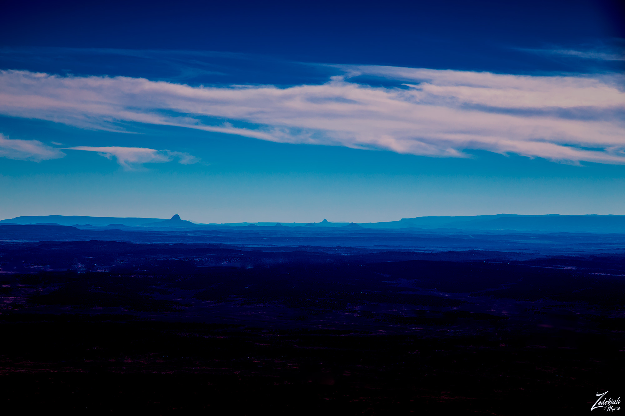 Huerfano Mountains & Jacarilla Tribal Lands ~ Click to Enlarge
Jicarilla Apache Lands
The tribal name of "Jicarilla", pronounced "heek-ah-REE-yah", comes from Mexican Spanish meaning "little basket" meaning "People who make little baskets". However the surrounding fellow Apache bands; Mescalero and Lipan called them "Kinya-Inde" meaning "People who live in fixed houses".
The Jicarilla reffered to themselves as "Haisndayin" translated as "People who came from below", because they believed they are the sole descendants of the very first people, who emerged from the underworld, which they see as the Original Abode (home) of Ancestral Man and Ancestral Woman who produced the first people on the earth. They call this reservation you see in the first and second photos "Dachizhozhin".
These are incredibly hardy people to live in such a seemingly harsh environment, but they learned about farming and pottery from the Puebloan peoples and also learned how to survive on the plains from the Plains Indians which provided sustenance via a rich and varied diet. They planted along the rivers, a variety of crops, sometimes using irrigation to aid in growing squash, beans, pumpkins, melons, peas, wheat, and corn. They found farming in the mountains safer than on the open plains. They primarily hunted buffalo, antelope, deer, mountain sheep, elk, and buffalo. From the wild, women gathered berries, agave, honey, onions, potatoes, nuts and seeds.
(Research Source)
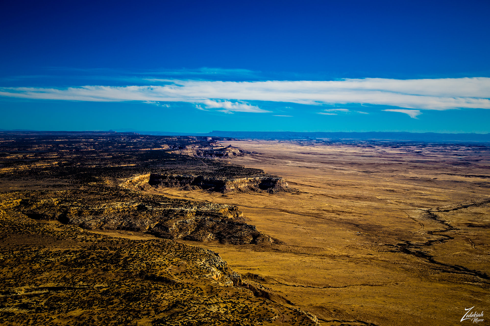
 Badland Hills of the Jicarillo Reservation ~ Click to Enlarge
I continued flying westward over the reservation lands and across Cańon Largo and over Sisnathyel Mesa. It was here that I spotted some very odd "bubble" formations all clumped together at the bottom of the sloped ridge of the western part of Sisnathyel Mesa.
This place was so small it barely shows up on a map and has no name. Go here to see a Google Map location and zoom out just and bit and it easily vanishes on the map. That is one of the advantages of exploring via bush plane in these remote areas. It is easy to spot these interesting geological anomalies.
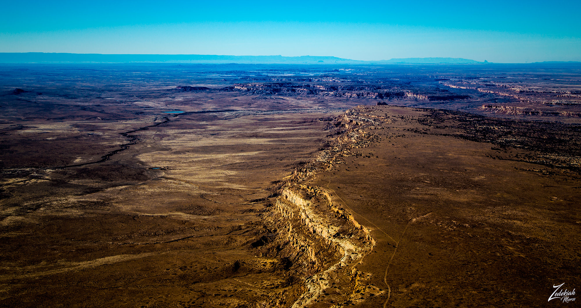
 Sisnathyel Mesa Outcrop ~ Click to Enlarge
There are some very interesting geological processes going on here. The black material is deeply carved and smoothed by long term erosion of a much higher layer, of which you can still see remnants on top. Oddly, the black strata itself is laying on top of multiple layers as you can see on the right side of the formation. One could surmise that this is an exposed piece of a very old volcanic layer which covers the Sisnathyel Mesa above and surrounding this formation. Whatever it is, it looks pretty otherworldly from above.
After taking a couple of pictures of this unusual formation I continued west, following above the Cañada Alemita river across the high desert mesa tops towards Chaco Canyon.
Chaco Canyon ~ Ancient Anasazi Lands
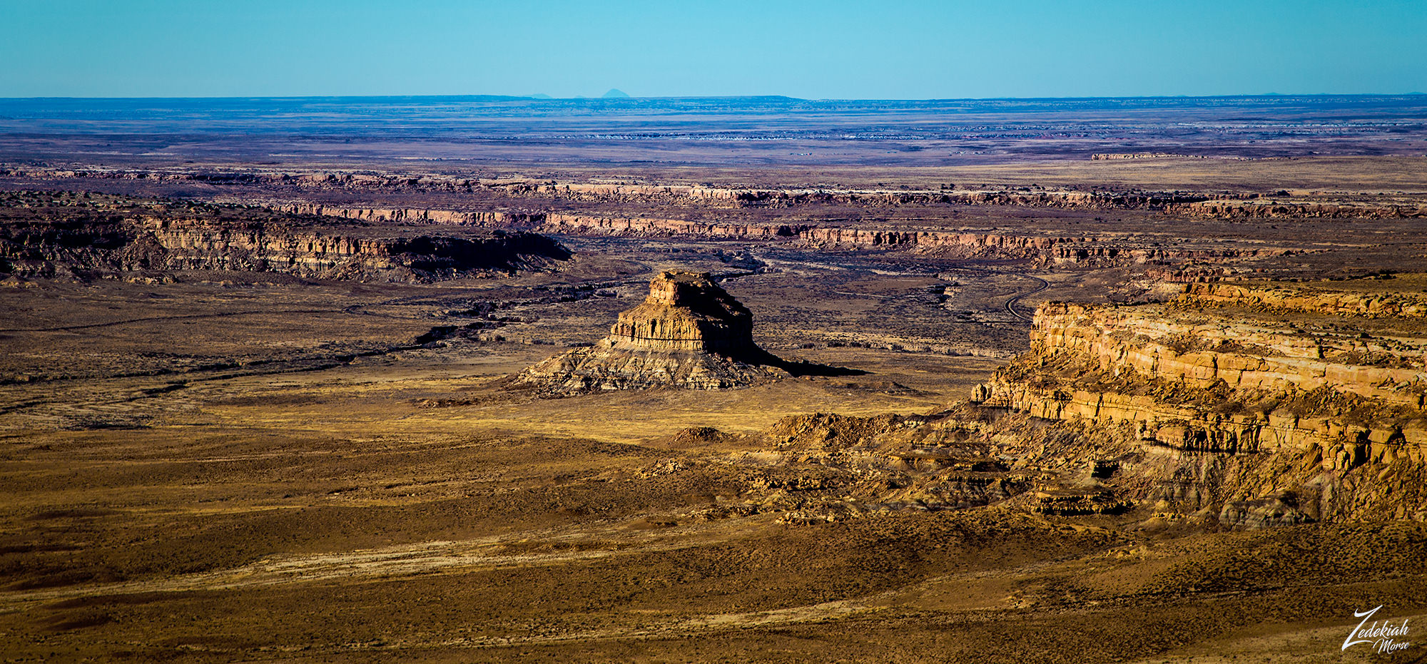
Crossing over the top western end of Chacra Mesa, you can see the abrupt cliff edge towering over Fajada Wash. In the distance along the river you can see historic Anasazi roads.
 Chacra Mesa Looking East ~ Click to Enlarge
Chacra Mesa is part of Chaco Culture National Historical Park, a National Historical Park hosting the densest and most exceptional concentration of ancient Anasazi pueblos in the American Southwest. This vast wilderness area contains the one of the most sweeping collections of ancient ruins north of Mexico. Here are preserved some of the most crucially important pre-Columbian cultural and historical areas in the world.
In the image directly above we are looking east along the edge of Chacra Mesa, in the image directly below we are looking west towards Chaco Canyon. If you follow the dirt road on the in the foreground of this image you can see where it splits off to the right into the middle of that mesa top prairie. This is the location of Tsin Kletsin, an Ancestral Puebloan great house and archaeological site.
Imagine if you can, just over 900 years ago there was an Anasazi Great House with 81 rooms, 3 kivas and a plaza constructed to create a 2-story structure. The plaza was enclosed by a wall, and a 1-meter-wide entry portal allowed access to the plaza from the south. The masonry style of this complex is called McElmo (Chaco-McElmo), characterized by large sandstone blocks and some tubular slabs. This was a beautiful home to many people!
(Research Source)
 Chacra Mesa Looking West ~ Click to Enlarge
Looking further to the top middle of the image you can see Chaco Canyon, this entire canyon in the distance is the Chaco Canyon National Monument. These are very sacred lands to the First Nations Diné (Navajo) and Hopi tribes people who are considered to be the descendants of the Ancient Anasazi.
The central portion of that canyon contains the largest Chacoan complexes. The most studied is Pueblo Bonito. Covering almost 2 acres (0.81 ha) and comprising at least 650 rooms, it is the largest great house; in parts of the complex, the structure was four stories high.
(Research Source)
 Fajada Butte & Entrance to Chaco Canyon ~ Click to Enlarge
Fajada Butte (Banded Butte) rises 135 meters above the canyon floor in this image I lensed as I flew out over Fajada Wash. This is also part of the Anasazi culture of Chaco Canyon. Although there is no water source on the butte, there are ruins of small cliff dwellings in the higher regions of the butte. Analysis of fragments of pottery found at these ruins show that these structures were used between the 10th to 13th centuries.
If you enlarge this image and look closely on the bottom left side of the butte in the middle you can see the remains of a 95-meter-high, 230-meter-long ramp going up the the first lower cliff. The sheer magnitude of this building project, done by hand and without an apparent utilitarian purpose, indicates that Fajada Butte may have had considerable ceremonial importance for the Chacoan people.
The is the end of Part 3, go here to watch Part 2 & stay tuned for Parts 4 & 5.
I lensed these images at different times while exploring this awe-inspiring wilderness area for my ongoing project, "Where Eagles Fly". p>
About The Project
Where Eagles Fly - The American Wilderness Expedition is my personal mission to introduce people to these amazing locations that surround us. I am piloting a bush plane while exploring and filming throughout the remote back-country areas of North America to raise awareness of the 47% of the USA and 90% of Canada that remain unpopulated wilderness.
About The Author
My name is Zedekiah Morse and I'm a Bush Pilot, Photographer, Explorer and Filmmaker. I live in the Rocky Mountains and devote my time and resources to exploring as much of the world as I can by air. If you wish to watch a short film detailing how I do my work and this project, go here.
If you like what you see here upvote and resteemit so that others may experience these wondrous places.
And if you'd like these images to be part of your feed, follow me.
Thanks for your support and Yehaw!!
nice post I like @skypilot
Generic comments could be mistaken for spam.
Tips to avoid being flagged
Thank You! ⚜
I followed since the first part this a great experiences
Good.... thanks for continuing to read this series... hope you like it all the way to the end.
I’m inlove with your posts!
Nice!!!! Yehaw.... I am grateful for your support.
great post @skypilot...
Thanks!!!
Beautiful photographs friend
Thank you .... glad you enjoy them
Wow, that shot of Chacra Mesa looking west is stunning! I love reading these posts, will be a shame to see the end of this series!
It is a really interesting place... especially when you envision people living on this mesa so many thousands of years ago.... seriously! can you imagine the night sky from here???? wow!! And I have a number of series planned like this one... so stay tuned!
I bet! I've been looking at light pollution maps a lot recently, I can't even imagine the visibility back then! I bet they felt a lot more connected to the universe than we do now! Looking forward to more!