Where Eagles Fly - Part 2 - Zapata Ranch, Colorado by Zedekiah Morse
Hello Steemit!
I'm a bush-pilot, aerial photographer, and explorer.
Our world is truly beautiful from up here!!
This is my second post from the series I'm writing for Steemit about my ongoing nature/adventure production: Where Eagles Fly - The American Wilderness Expedition.
If you would like to read my introduction post and watch the first teaser clip, please go here.
Part 2 - Visiting the Zapata Ranch ~ Wildlife Mecca
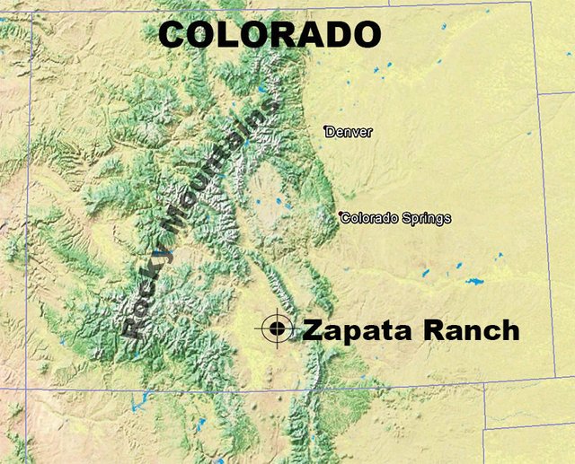
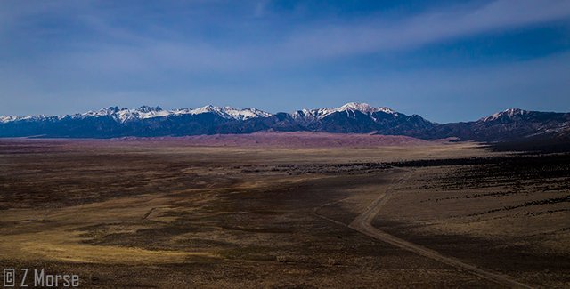
Zapata Ranch, a working bison, cattle, and horse ranch, is a classic western ranch, spreading out over 160 sq. miles across the eastern side of the immense San Luis Valley.
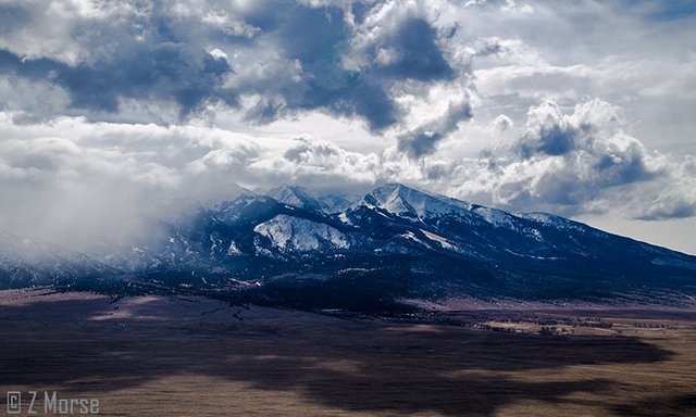
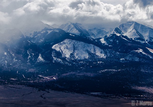
Zapata Ranch below Blanca Peak in the Sangre de Cristo Range of the Rocky Mountains
The ranch headquarters, workshops, kitchen and lodge are all located right below the base of Blanca Peak and off to the right hand side of the above image. I took this photo from about 3,000 feet above ground out over the San Luis Valley and above the Zapata Ranch range.
As you can see the ranch is located in a large basin valley that extends into New Mexico. On the east side of the valley is the Sangre de Cristo mountain range and on the west side are the San Juan Mountains, all a part of the Rocky Mountains.
Blanca Peak
The imposing Blanca Peak is 14,345 feet (127m) high and situated in the middle section of the 79 mile (127km) long Sangre de Cristo mountain range in the Rocky Mountains of southern Colorado.
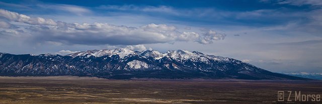
Blanca Peak and the Sangre de Cristo Mountain Range
Blanca Peak is revered by the First Nations Diné (Navajo) as a sacred mountain and is called ~ Tsisnaasjiní ~ which means Dawn or White Shell Mountain. The mountain is considered to be the eastern boundary of the Dinetah, the traditional Navajo homeland. It is associated with the color white, and tribal traditions say it is "Covered in Daylight and Dawn and Fastened to the Ground with Lightning!".
To read more about the traditional Diné view of this powerfully beautiful mountain go here.
The San Luis Valley
The San Luis Valley is a high-altitude depositional basin. Also known geologically as the Alamosa Basin, it is home to the headwaters of the famous Rio Grande River, which, depending on how you measure (the river occasionally shifts course naturally) it is about 1,896 miles (3,051 km) long. The river even forms a stretch of the Texas border between the USA and Mexico. This valley is also home to the Great Sand Dunes National Park.
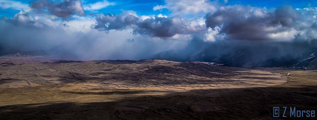
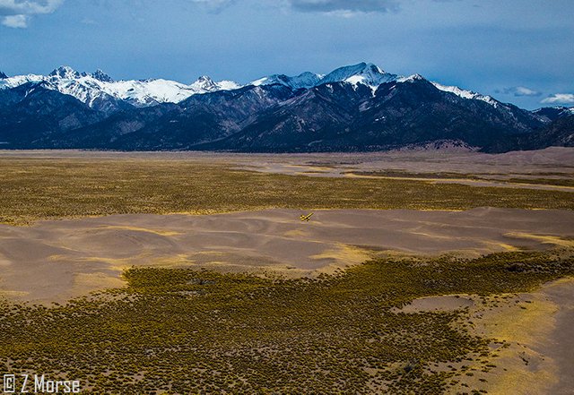
An interesting shot of the Great Sand Dunes under a localized rain shower
The San Luis Valley is approximately 122 miles (196 km) long and 74 miles (119 km) wide, extending from the Continental Divide on the northwest rim into New Mexico on the south. This vast valley covers approximately 8,000 square miles (21,000 km2) and sits at an average elevation of 7,664 feet (2,336 m) above sea level.
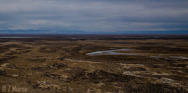
San Luis Valley looking east toward the San Juan Mountains with Bison Herds at the bottom
Early Inhabitants
This long, wide valley has a rich and colorful First Nations history. Very early Paleo-cultures were the first known inhabitants around 11,000 years ago. Early paleolithic hunters tracked long-extinct ice age animals in the valley. And tribes from the upper Rio Grande Pueblos also traveled north to hunt in the valley at times, which would cause conflict. First Nations Utes finally established their dominance in the valley, but were frequently raided by Plains tribes such as the Comanche, Cheyenne, Arapahoe, and Kiowa.
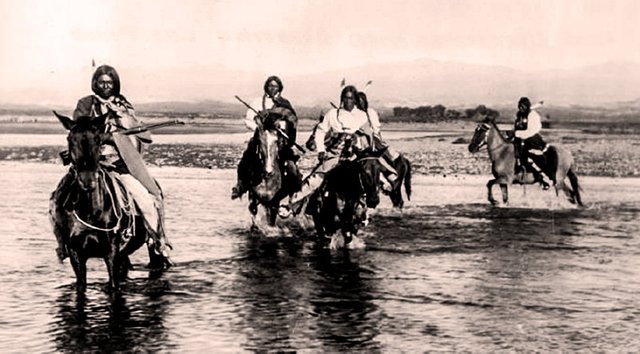
Historic photo of First Nations Ute Warriors crossing a creek
Jicarilla Apaches lived in peaceful harmony with the Utes and frequently camped in the southern end of the valley. The Capote band of Utes occupied the southern end of the valley at the time of the first contact with pioneers. Another band, the Mohuache, also lived in southern Colorado and the Weeminuche band also ranged in the western end of the valley, generally west of the San Juan Mountains.
Zapata Ranch
Located in the shadows of the Sangre de Cristo mountain range, on the remote San Luis Valley floor near Alamosa, Colorado, Zapata Ranch and the surrounding valley is a veritable mecca for wildlife. Home to large numbers of elk, bison, deer, coyotes, birds, and many other species, this is a wonderful place which I truly enjoy visiting while filming the wilderness back-country in the Rocky Mountains.
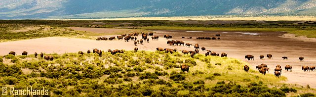
Bison herd on the Zapata Ranch in the San Luis Valley
Zapata Ranch is an inspirational place to get away from city crowds and experience the beauty and serenity of Rocky Mountain nature in this enormous valley encircled by numerous towering 14,000 foot high mountains. High desert grasslands, alpine forests, wetlands, sand dunes, creeks, and lush meadows provide an immersive opportunity to experience one of the most scenic and ecologically diverse landscapes in the United States.
To learn more about visiting this amazing place check out their website: Zapata Ranch
Zapata Ranch and the Great Sand Dunes National Park below the Sangre de Cristo Range
This sprawling 103,000 acre ranch is owned and protected by the Nature Conservancy and managed through a one-of-a-kind partnership with Ranchlands, a highly specialized company with a unique approach to running large-scale ranches. Founder and CEO, Duke Phillips, is a 3rd generation rancher and fellow bush-pilot.
Duke Phillips, the “Flying Cowboy”.
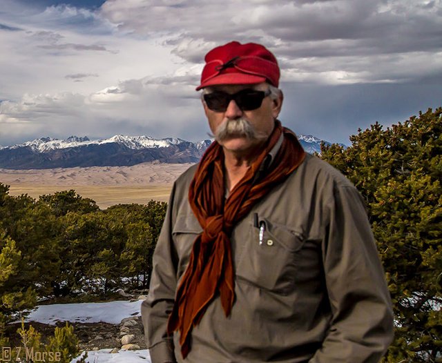
3rd Generation Rancher & Flying Cowboy ~ Duke Phillips
Duke and his son (also Duke) are hardworking cowboys in the truest traditional manner. They work constantly in all sorts of weather alongside a small, dedicated crew of men and women to maintain the huge expanse of land the ranch occupies. It is a great deal of sweat and toil to manage the herds of bison and horses along with the migratory herds of elk that wander through the open ranges of the ranch.
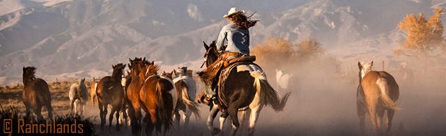
Herding horses on the Zapata Ranch
Aside from riding the range on horseback mending fences, branding cattle, rounding up horses, and searching for strays, Duke and his son (also a bush-pilot) must regularly fly between Zapata and the other ranches they manage around the area. They use their bush-plane to quickly get back and forth over the mountains to save time, sometimes in not so nice weather! What takes hours to drive takes a short time to traverse by bush-plane.
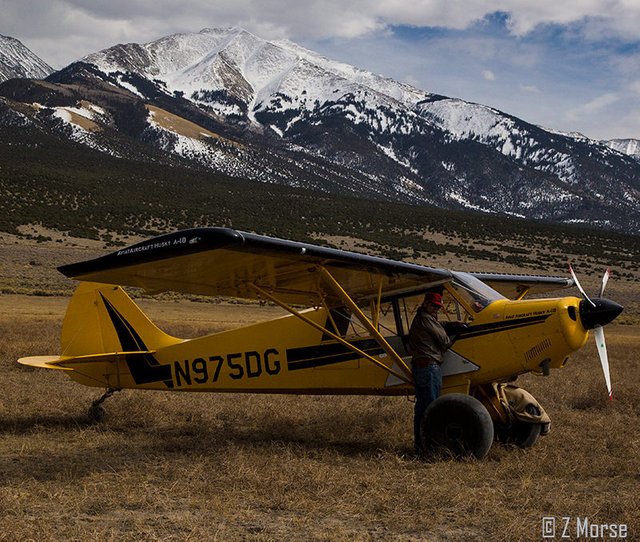
Duke and his Aviat-Husky Bush-Plane returning from a scouting mission
They also use the bush-plane to scout out herd locations, look at water levels in the river, check on migratory elk and look for missing animals or ranch hands. It is much easier looking over a large area by bush-plane than riding for hours over rough terrain on horseback, motorcycle or ATV. Plus if necessary they can land on the hardscrabble valley floor or on any number of dry river beds and creeks that run throughout the range.
If you look closely you can see Duke's yellow bush-plane flying low over the dunes
Experimental Fly-Along Vignette Film
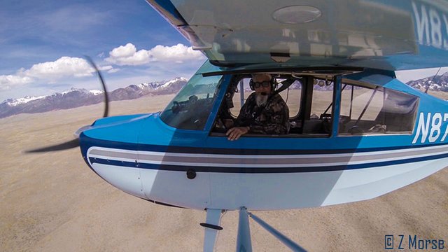
On this particular trip I dropped by to visit Duke on a late spring afternoon while out shooting the Rockies around Durango, Colorado. As this is part of my process to conduct cinematic tests for the custom 360° aerial camera platform I am designing, I set up to film a fly-along session with Duke. I followed him in his bush-plane as he led me on a aerial tour of the vast Zapata ranch.
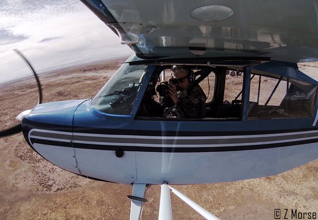
Zedekiah Shooting above the Zapata Ranch, San Luis Valley, Colorado
I filmed the process as we took off from a dry river bed and flew around the San Luis Valley before landing on the prairie out by the ranch. I edited this as a "fly-along" experimental vignette, sans music and with only the ambient sounds of the wind and airplane as Duke and I converse of the radio while flying around the ranch. I wanted to provide a sense of what it is like to operate in the air as I shoot these remarkable places. This is part of an ongoing set of tests I am doing for the project. There is another part of the test that I am still working on I will showcase at a later date that I feel will be a great asset to the project.
If you'd like to watch this experimental vignette please click on the image below. If you are viewing this on your cell phone and the image below does not appear then go here.
The Buffalo-Bear on Blanca Peak
One thing I would like to mention that is particularly cool to witness is the formation that occurs on the western slope of Blanca Peak, looking out over the valley above Zapata Ranch. You can see it in the second picture from the top of this post but I have a close up here below. The folks at the ranch call it Buffalo-Bear. It shows up very clearly when it snows and resembles a big bear sniffing along the ground to the right, and a buffalo facing the wind and elements to the left. Can you see it?
Buffalo-Bear on Blanca Peak in the Sangre de Cristo Mountain Range
Ok, that's a Wrap!
Thanks for taking time to read this article, if you like it please vote and I would love to hear from you as well, so if you can, take time to leave a comment or ask a question. My ongoing goal here on Steemit is to utilize this platform to gauge community response to my project, in order to evaluate the level of interest from the public about this subject matter. I'll have more information on the project in my next post.
Also for those folks on Facebook, please come say hello. I am simply Zedekiah Morse. Stay tuned for the next installment of Where Eagles Fly - The American Wilderness Expedition.
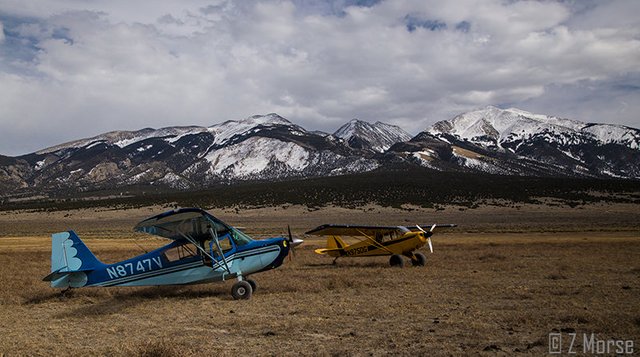
Bluebird and the Yellowbird on the prairie under the gaze of Buffalo-Bear on Blanca Peak
To view images from the project Where Eagles Fly - The American Wilderness Expedition please view my other posts. I am on a mission to raise awareness of our Iconic Natural Heritage Treasures of North America.
And if you would like, press the button to automatically follow my stories! Love to have you on board.

Hi @skypilot,
You have been chosen as a featured author by the @robinhoodwhale initiative.
Learn more about the Robinhood Whale here!
Keep on Steeming more amazing posts!
Goodluck!
~RHW~
Wow! Thank you so much folks! I am honored!!! yehaw
Interesting pictures!
thanks!
This is just awesome , great photos mixed with some history of the place .
Got some for ya
Nice!!!! Thanks... you KNOW this place has some stories to tell!!!
I enjoyed this. It looks like you've got your camera system working well. What a life you have!
Thanks, I am still working on the method and the new 360 camera system. Stay tuned!!! yehaw
The 360 camera system would be awesome!
The winds you get in these areas must at times be pretty harrowing?
You bet they are!!! Notice the roll cage padding on the cross bars in the cockpit. That is because I once got caught in a roller... horizontal vortices coming off the windward side of the Sierra Nevada mountains above Bishop, California... and it threw me into the ceiling pretty hard ... hence the pads! But wind also provides lift so the old saying goes "the wind is your friend until your wings it bends!"
This is some Indiana Jones 'ish! Nice.
Very cool! A dream in reality
Thanks for the kind words! I truly love doing this for real!
Really love this, Z. It felt like being actually there.
Thanks chaeya, that was the intent, to allow people to virtually experience the journey. I'm glad you like it!
another great post, love the pictures and the information. The wildness is spectatular .
Thanks Lady Penelope... it truly is spectacular! I am glad you enjoy, this is exactly why I am doing this.
Your velocity is of course much greater than an ultralight when you land. Looks dangerous.
Professional setup you have with the multiple video cameras.
Thanks, anonymint... yes I am much heavier than an ultralight however I don't feel it is any more dangerous, this is why you train continuously!
Ok
Goodluck
thanks, to you as well