Rain Storm on the Great Sand Dunes National Park
Isolated Rain Storm
I came upon this strange isolated rain storm over the Great Sand Dunes when I was flying out over the San Luis Valley while filming Zapata Ranch. It was clear skies about the rain clouds and clear all around it... yet it was raining on this stretch of the Sangre de Cristo Range in the Rocky Mountains.
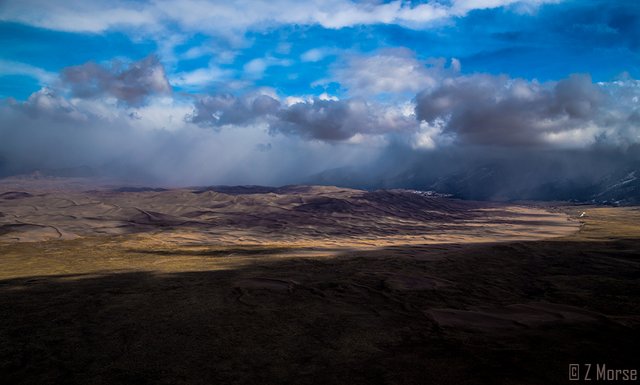
In this photo you can clearly see the curving edge of the sand dunes boundary where the dunes delineate from the San Luis Valley floor. These are the tallest sand dunes in North America reaching heights of 750 feet (228m).
Sand From an Ancient Glacial Lake
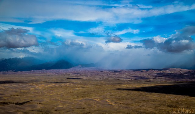
The dunes were formed within the last 500,000 years from sand and soil deposits of the Rio Grande and its tributaries as they spread out through the San Luis Valley. Over the ages, the glaciers melting created a vast lake in the San Luis Valley... as this lake and the waters evaporated and drained to form the river, it left behind massive volumes of loose sand. Westerly winds then picked up sand particles from the lake and river flood plain and carried them across the valley floor. As the wind diminished in power before crossing the Sangre de Cristo Range, the sand deposited all along the eastern edge of the valley. As the sand stacked up over time it became what we see today, the Great Sand Dunes National Park.
In the photo above taken from the same position as the previous photograph, you can see the small Mount Seven Peak and behind it the snow capped 13,200 (4,023m) Cleveland Peak of the Sangre de Cristo Mountain Range peeking through the rain shower.
Whipped By Fierce Winds
The wind continues to whip about and shape and reshape the dunes on a daily basis, and continue to increase the volume of sand and size of the dunes. These fierce winds are strong enough to move sand and small rocks from miles away across the valley. While the dunes don't actually change location or vary in size that often, the wind forms parabolic dunes that grow in the sand sheet, the outer area around the dunes, and migrate towards the main dune field, giving a very prominent beveling or warping visual effect, especially notable from up above where I fly.
Located near Alamosa, Colorado just north of the Nature Conservancy's Zapata Ranch the dunes are a great place to visit. To check out the National Parks Service website on the Great Dunes National Park go here.
And to check out my previous exciting fly-in trip to the Zapata Ranch to visit Duke Phillips the Flying Cowboy, go here.
If you're unfamiliar with my work please check out my introductory post here.
Ok thanks, hope you enjoy this and yehaw!
To view images from the project Where Eagles Fly - The American Wilderness Expedition please view my other posts. I am on a mission to raise awareness of our Iconic Natural Heritage Treasures of North America.
And if you would like, press the button to automatically follow my stories! Love to have you on board.

Beautiful photos. Following.
Thank you countryinspired! This is exactly why I am sharing these images...
beautiful pictures - i love watching rain clouds come in over land
Thanks you, I do as well... rain from in the air is quite a different experience than on the ground.
Not many people can say they have seen rain clouds from that perspective. Can't wait to see where to next.
thank you Bonnie.... :)
Beautiful pictures of nature. Wish I can experience it first hand