MY 2018: TOUR AROUND MY TOWN (CITY), IN KANO STATE, NIGERIA. my ENTERY for CONTEST: My 2018: A tour around my town - 100 SBD in Prizes
BRIEF OVERVIEW OF OF KANO STATE
THIS IS KANO, NIGERIA " THE CENTRE OF COMMERCE" 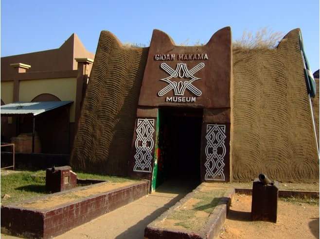
Kano State is a state located in North-Western Nigeria. Created on May 27, 1967 from part of the Northern Region, Kano state borders Katsina State to the north-west, Jigawa State to the north-east, Bauchi State to the south-east and Kaduna State to the south-west. The capital of Kano State is Kano.
Kano became known to the outside world after the visits of the Leo Africans in AD 1513. tradition has it that the earliest settlers found in the area were the Abagayawa whose ancestor called Kano was said to have migrated from Gaya in the vicinity of Kano town in search of Iron-stone and charcoal. The small settlement evolved some sort of patrilineal organisation structure at the apex of which was a man called BARBUSHE - a hunter, a priest, an able leader and a man of enormous stature. Tradition credits him with so much prowess and strength, he was according to oral tradition, able to kill an elephant with a stick and carry it on his back. Barbushe was the high priest of the supreme deity, TSUMBURBURA, around whose worship this small peaceful community was built. The shrine of this deity is sited at a tree on the DALA HILL.
Kano is largely Muslim. The majority of Kano Muslims are Sunni. Christians and followers of other non-Muslim religions form a small part of the population, and traditionally lived in the Sabon Gari, or Foreign Quarter.
Kano City has been the capital of Kano State since the earliest recorded time.
Location: 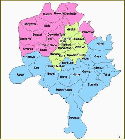
It is located on latitude 120 N and longitude 8.300 E within the semi-arid Sudan savannah zone of West Africa about 840 kilometers edge of the edge of the Sahara desert. Kano has a mean height of about 472.5m above sea level. Kano City has expanded over the years and has become the third largest conurbation in Nigeria with a population of about 3 million. It is made up of nine local government areas: Municipal, Gwale, Dala, Tarauni, Nassarawa, Fagge, Ungogo, Kumbotso and Dawakin Kudu. Kano’s most enduring legacy Gidan Rumfar (Emir’s Palace) the seat of Kano’s prestigious Sarauta institution (Kingship) built over five hundred years ago is located in the Municipal Local Government Area. The Kano State Government House is located in Tarauni Local Government Area.
Kano consists of wooded savanna in the south and scrub vegetation in the north snd is drained by the Kano-Chalewa-Ha
dejia river system. The state's light sandy soils are excellent for growing peanuts(groundnut) a major export. Other crops include, cotton, onions, indigo, tobacco, wheat, gum arabic, sorghum, beans, cowpeas and maize. Cattles, horses, goats and sheeps are grazed and hides and skin are exported. In Kano tin and columbite are mined.
Most of the State's inhabitants are Hausas and Fulanis, but ther are also Nigerians form other parts of the country, Arab traders and Europeans.
The state originally included Jigawa State which was made a separate state in 1991.
ECONOMY AND SOCIETY
Historically, Kano State has been a commercial and agricultural state, which is known for the production of groundnuts as well as for its solid mineral deposits. The state has more than 18,684 square kilometres (7,214 sq mi) of cultivable land and is the most extensively irrigated state in the country.
Foreign investments and investors can be seen all over the city. It is arguably within the first five states in terms of commercial activity within Nigeria. Kano also has traditionally received the largest proportion of centrally collected (mostly oil) revenues. From 1990-96 Kano received 10.9% of allocated revenue. In contrast, the next highest state was Sokoto State, receiving 3.5%, with Abuja, Lagos State, and Akwa Ibom State receiving 3.2% each.
#TOURIST ATTRACTIONS:
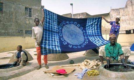
Kofar Matar Dyeing Pits 
The Kano indigo-vegetable dyeing pits is one of the most fascinating aspects of the old city. Various designs are folded into the material before dyeing and the fabric is often beaten to achieve the shiny, indescent appearance. The techniques employed to obtain this look are unmatched around the world. And, although the methods they use are ancient, these lush works of art on fabric always remain extremely popular and continue to be in great demand.
Others are; Kano City Wall, Durbar Festival, Kano State historic museum, Kano City gates and walls, Kurmi Market, Minjinrin Weaving Centre, Dawakin Tofa Pottery, Tiga Dam, Audu Bako Zoological garden, Bagauda Lake Hotels and Resorts, Kusalla Dam and Fishing Centre, Falgore Game Reserve and it festivities.
@sidom.baet & @anomadsoul thank you for making out time to appreciate my city
Thank you for taking part in this months #culturevulture challenge. Good Luck.