Ptolemy’s Tribes of Ireland
In his description of Ireland, Geography 2:2 §§ 1-10, Claudius Ptolemy records the disposition of sixteen native tribes.
There follows an English translation of the relevant sections of Ptolemy’s original text, Geography, Book 2, Chapter 2, §§ 2, 4, 6 and 8, which is repeated from the second article in this series. For the most part I have followed Karl Müller’s Paris edition of 1883. In Friedrich Wilhelm Wilberg’s edition (Essen 1838), which I also consulted, this chapter is numbered Book 2, Chapter 1. Chain brackets, {}, enclose italicized passages from Wilberg that are not in Müller. I have omitted the Greek accents, which were only introduced in Byzantine times. I have occasionally emended Müller in the light of T F O’Rahilly’s analysis of the subject (O’Rahilly 1-42, 453-466, 537-538).
The North Coast
2 The Venniknioi inhabit the western part of this coast; beyond these and extending to the east are the Rhobogdioi.
The West Coast
4 Beyond the Venniknioi this coast is inhabited by the Erdinoi, south of whom are the Magnatai {Nagnatai}; then the Auteinoi; then the Ganganoi, south of whom are the Vellaboroi.
The South Coast
6 Beyond the Vellaboroi this coast is inhabited by the Ivernoi, beyond whom are the Ousdiai {Vodiai} and more to the east the Brigantes.
The East Coast
8 Beyond the Rhobogdioi this coast is inhabited by the Darinoi, south of whom are the Volountioi; then the Eblanioi {Eblanoi}; then the Kaukoi, south of whom are the Manapioi; then the Koriondoi, beyond the Brigantes.
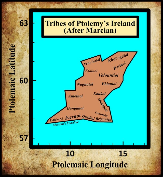
I have once again adopted the alteration of the southern coast of Ptolemy’s map of Ireland made by the 4th-century geographer Marcian of Heraclea. I presented my reasons for accepting Marcian’s emendations in an earlier article in this series, so I will not repeat them here (see Orpen 121-122 for details). Ptolemy’s map does look somewhat bare, as though there are not enough tribes to occupy the entire island. In Marcian’s emended version, however, the sixteen tribes fill out the island. The area of Marcian’s Ireland is also a better fit: as we saw in an earlier article, Ptolemy’s Ireland is substantially bigger than the real thing.
We have also seen that Ptolemy adapts the names of a number of these tribes to designate some of the geographical features of the island:
| Tribe | Related Toponym |
|---|---|
| Venniknioi | Venniknian Cape |
| Rhobogdioi | Rhobogdian Cape |
| Magnatai [Nagnatai] | Magnata City [Nagnata City] |
| Ivernoi | Iernos River |
| Ivernoi | Ivernos City |
| Manapioi | Manapia City |
| Eblanioi | Eblana City |
In the relevant articles for these features, I deferred any discussion of the etymology of their toponyms to the articles concerning the corresponding tribes. So we will be revisiting some of these places in the forthcoming articles.
References
- Karl Wilhelm Ludwig Müller (editor & translator), Klaudiou Ptolemaiou Geographike Hyphegesis (Claudii Ptolemæi Geographia), Volume 1, Alfredo Firmin Didot, Paris (1883)
- Thomas F O’Rahilly, Early Irish History and Mythology, Dublin Institute for Advanced Studies, Dublin (1946, 1984)
- Goddard H Orpen, Ptolemy’s Map of Ireland, The Journal of the Royal Society of Antiquaries of Ireland, Volume 4 (Fifth Series), Volume 24 (Consecutive Series), pp 115-128, Dublin (1894)
- Claudius Ptolemaeus, Geography, Biblioteca Apostolica Vaticana, Vat Gr 191, fol 127-172 (Ireland: 138v–139r)
- Friedrich Wilhelm Wilberg, Claudii Ptolemaei Geographiae, Libri Octo: Graece et Latine ad Codicum Manu Scriptorum Fidem Edidit Frid. Guil. Wilberg, Essendiae Sumptibus et Typis G.D. Baedeker, Essen (1838)
Image Credits
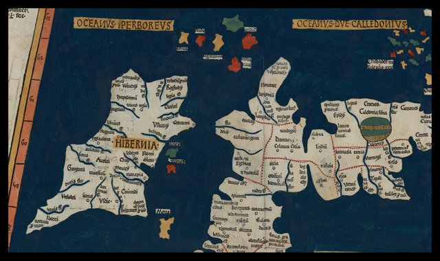
- Ptolemy’s Map of Ireland: Wikimedia Commons, Nicholaus Germanus (cartographer), Public Domain

Fantastic history congratulations friend
Excellent history and very nice article.
Thanks for share this post...
Thanks for the crutual historical post.loved it