Οὐεννικνιον Ακρον
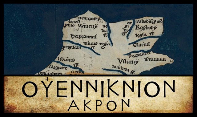
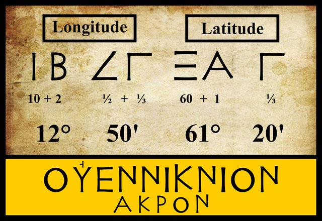
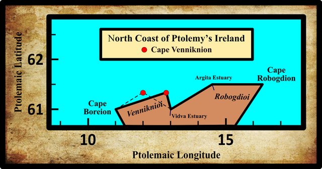
Sailing along the north coast of Claudius Ptolemy’s Ireland from east to west, the next landmark we come to after the River Vidva is the promontory Cape Venniknion. The three modern editions that I am following agree on the latitude and longitude of this headland, but several of the older manuscripts give the longitude as 12°:
| Edition or Source | Longitude | Latitude |
|---|---|---|
| Müller | 12° 50' | 61° 20' |
| Wilberg | 12° 50' | 61° 20' |
| Nobbe | 12° 50' | 61° 20' |
| X, Σ, Ω, Ψ, M, D | 12° 00' | 61° 20' |
X is Vaticanus Graecus 191, one of the earliest Byzantine manuscript sources of Ptolemy’s Geography. It is now in the Vatican Library.
Σ, Ω and Ψ are three manuscripts from the Laurentian Library in Florence: Florentinus Laurentianus 28, 9 : Florentinus Laurentianus 28, 49 : Florentinus Laurentianus 28, 42.
M is the Editio Argentinensis, which we have met several times before. It was based on Jacopo d’Angelo’s Latin translation of Ptolemy (1406) and the work of Pico della Mirandola. Many other hands worked on it—Martin Waldseemüller, Matthias Ringmann, Jacob Eszler and Georg Übel—before it was finally published by Johann Schott in Straßburg in 1513.
D is one of the Codices Parisini Graeci in the Bibliothèque nationale de France in Paris (Grec 1402).
There are also several variant readings of the name of this feature:
| Source | Greek | Roman |
|---|---|---|
| Müller | Οὐεννίκνιον | Venniknion |
| D, Vin, Ξ, Σ, Ψ | Οὐεννίκνειον | Vennikneion |
| M | Οὐεννίκνειος | Vennikneios |
| C, P, R, V, W | Οὐενίκνιον | Veniknion |
| Φ | Οὐενίκον | Venikon |
Vin is Vindobonensis 1, a codex in the Austrian National Library in Vienna.
Ξ is Barberinus, a codex from the library of Cardinal Francesco Barberini. It is now housed in the Vatican Library
C is another Parisian manuscript.
P and R are Venetian manuscripts identified by Müller as Venetus 383 and Venetus 516. They are possibly kept in the Biblioteca Nazionale Marciana, though I have not been able to confirm this.
V and W are two more manuscripts in the Vatican Library, Vaticanus Graecus 177 (Ireland on p 39b) and Vaticanus Graecus 178.
Φ is another manuscript from the Laurentian Library in Florence: Florentinus Laurentianus 28, 38.
Identity
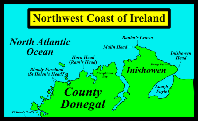
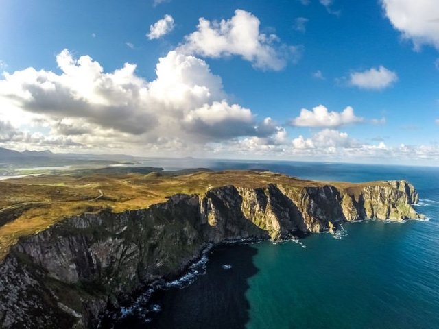
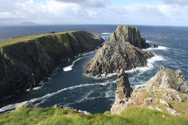
In the early 17th century, the British antiquary William Camden identified Ptolemy’s Cape Venniknion with Ram’s Head, or, as it is known today, Horn Head, which forms the western entrance to Sheephaven Bay in County Donegal. This is still a popular choice. James Ware and his editor Walter Harris agreed with Camden, and in the 19th century, when Samuel Lewis published his Topographical dictionary of Ireland, it was still the received opinion.
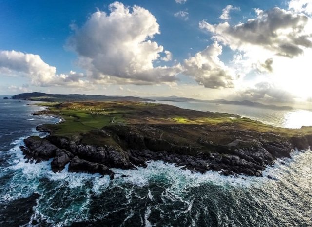
At some time in the 19th century, scholars began to favour Malin Head, some 40 km to the north-east. Karl Müller, whose 1883 edition of Ptolemy I am following, acknowledged this view, though Müller himself dissented from both opinions:
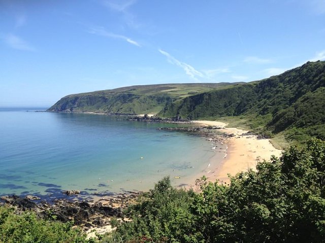
Today this promontory is usually identified with Malin Head, which is the most northerly point of the island. However, since, according to Ptolemy, it lies about 550 stadia from the Northern Promontory, it is preferable to identify it with Inishowen Head, at the entrance to the bay known today as Lough Foyle. (Müller 75)
Strictly speaking, Malin Head is not the most northerly point in Ireland—that distinction belongs to Banba’s Crown, a tiara-shaped rock about 2 km to the north-east of Malin Head—but even the Irish frequently confuse the two. Müller, as we shall see in the next article in this series, identified Ptolemy’s Northern Promontory with Bloody Foreland. The Ptolemaic stadion was about 185 m (Cuntz 111), so 550 stadia is about 102 km. Malin Head is only about 61 km from Bloody Foreland. Inishowen Head is about 86 km as the crow flies, and about 100 km if one follows the coast. So perhaps Müller has a point. But we have already seen that Ptolemy’s Ireland is significantly larger than the real thing, so this sort of tape-measuring is of limited use. We have also seen that several early sources gives 12° as the longitude of Cape Venniknion, which would place it about 38.5 km west of Müller’s 12° 50':
Nevertheless, Müller’s identification of Cape Venniknion with Inishowen Head has its supporters today—including the contributors to Roman Era Names.
Goddard Orpen’s analysis of Ptolemy’s description of Ireland was partially informed by Müller’s, but he opted for Malin Head. Charles Trice Martin, writing around the same time, preferred Horn Head, as do most contemporary commentators. Louis Francis, however, opts for Malin Head. For once, I find myself in agreement with Francis—more or less. I would tentatively identify Cape Venniknion with Banba’s Crown. It would be strange if Ptolemy recorded three headlands on the north coast of Ireland, but omitted the most northerly point of the island.
As Ptolemy’s Cape Venniknion is named for a local tribe, the Οὐεννικνιοι (Venniknioi), I will discuss the etymology of the name when I come to deal with them.
| Horn Head (Ram’s Head) | Malin Head | Inishowen Head |
|---|---|---|
| Camden (1607) | - | - |
| Ware (1654) | - | - |
| Lewis (1837) | - | - |
| - | - | Müller (1883) |
| Martin (1892) | - | - |
| - | Orpen (1894) | - |
| Mac an Bhaird (1991-93) | - | - |
| - | - | Francis (1994) |
| Darcy & Flynn (2008) | - | - |
Source: Darcy & Flynn 56 (corrected)
References
- William Camden, Britannia: Or A Chorographical Description of Great Britain and Ireland, Together with the Adjacent Islands, Second Edition, Volume 2, Edmund Gibson, London (1722)
- Otto Cuntz, Die Geographie des Ptolemaeus: Galliae, Germania, Raetia, Noricum, Pannoniae, Illyricum, Italia, Weidmann, Berlin (1923)
- Robert Darcy & William Flynn, Ptolemy’s Map of Ireland: A Modern Decoding, Irish Geography, Volume 41, Number 1, pp 49-69, Geographical Society of Ireland, Taylor and Francis, Routledge, Abingdon (2008)
- Samuel Lewis, A Topographical Dictionary of Ireland, Volume 1, S Lewis & Co, London (1840)
- Charles Trice Martin, The Record Interpreter: A Collection of Abbreviations, Latin Words and Names Used in English Historical Manuscripts and Records, Reeves and Turner, London (1892)
- Karl Wilhelm Ludwig Müller (editor & translator), Klaudiou Ptolemaiou Geographike Hyphegesis (Claudii Ptolemæi Geographia), Volume 1, Alfredo Firmin Didot, Paris (1883)
- Karl Friedrich August Nobbe, Claudii Ptolemaei Geographia, Volume 2, Karl Tauchnitz, Leipzig (1845)
- Goddard H Orpen, Ptolemy’s Map of Ireland, The Journal of the Royal Society of Antiquaries of Ireland, Volume 4 (Fifth Series), Volume 24 (Consecutive Series), pp 115-128, Dublin (1894)
- Claudius Ptolemaeus, Geography, Biblioteca Apostolica Vaticana, Vat Gr 191, fol 127-172 (Ireland: 138v–139r)
- James Ware, Walter Harris (editor), The Whole Works of Sir James Ware, Volume 2, Walter Harris, Dublin (1745)
- Friedrich Wilhelm Wilberg, Claudii Ptolemaei Geographiae, Libri Octo: Graece et Latine ad Codicum Manu Scriptorum Fidem Edidit Frid. Guil. Wilberg, Essendiae Sumptibus et Typis G.D. Baedeker, Essen (1838)
Image Credits
- Ptolemy’s Map of Ireland: Wikimedia Commons, Nicholaus Germanus (cartographer), Public Domain
- Greek Letters: Wikimedia Commons, Future Perfect at Sunrise (artist), Public Domain
- Horn Head (Ram’s Head): © 2018 Activeme.ie, Raymond Fogarty (photographer), AirCam, Fair Use
- Malin Head: © Duncan Hutt (photographer), Fair Use
- Banba’s Crown: © 2018 Activeme.ie, Raymond Fogarty (photographerAirCam, Fair Use
- Kinnego Bay, with Inishowen Head: © 2008-17 Susan Byron, Fair Use

really very talented history of ireland.. This type of content is very valuable here at Steemit and it is very valuable, you have been uploading very good quality content to Steemit for a long time and I love learning more because I can discuss new topics with my friends, I just have to give them the Thank you. my dear good friend.. @harlotscurse
Excellent post good article and photography dear @harlotscurse
Wow! such a wonderful history D :) friend @harlotscurse . I love your post. Thank you for sharing with us "
wondarful history ..i like it ..thanks for share ..dear @harlotscurse
Amazing history and very nice article
Really i also love your work
Thanks for share this post
It's good that you're back friend with this great work great story
Excellent post about Irland a great story friend congratulations thank you for sharing with us always
I love history and those beautiful places I want to know
Very nice history. Really i like this post . Thanks for share
Excellent history and very nice article. Really I like it " thank you for share