’Αργιτα
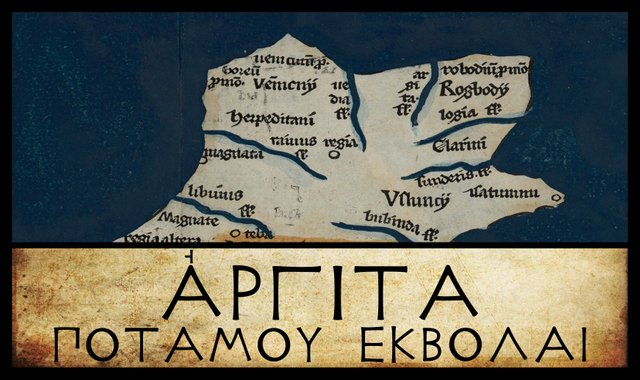
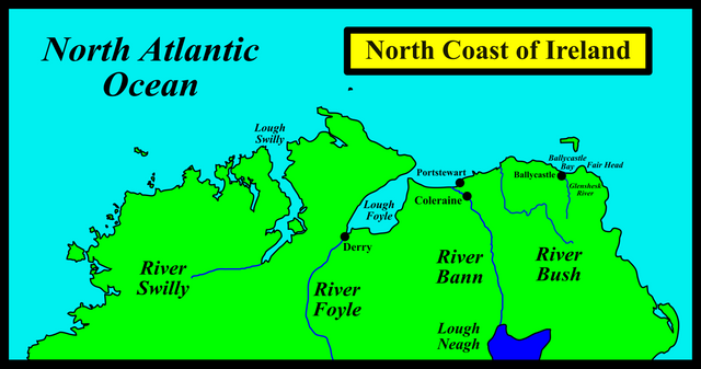
Having doubled the cape of Fair Head, we have now reached the northern coast of Ptolemy’s Ireland. Our first landfall is another river mouth, the Argita. No consensus has ever been reached on the identity of this feature. Over the centuries, it has been variously identified with two inlets, Lough Swilly and Lough Foyle, and with two rivers, the Bann and the Bush.
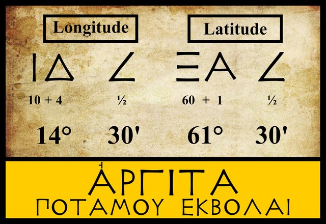
Ptolemy’s Coordinates
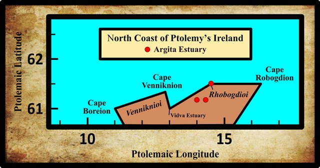
Argita is another of those landmarks whose precise location varies quite a bit from manuscript to manuscript. Ptolemy’s 19th-century editors, Müller, Wilberg and Nobbe, agree on both the latitude and longitude, and all sources have the same numbers for the degrees. A handful of the manuscript sources, however, give different numbers for the minutes of arc. Among these is the early Byzantine manuscript Vaticanus Graecus 191:
| Edition or Source | Longitude | Latitude |
|---|---|---|
| Müller | 14° 30' | 61° 30' |
| Wilberg | 14° 30' | 61° 30' |
| Nobbe | 14° 30' | 61° 30' |
| Vaticanus Graecus 191 | 14° 00' | 61° 10' |
| Φ, Latin 4803, Editio Argentinensis | 14° 00' | 61° 10' |
| Σ | 14° 20' | 61° 10' |
Sources: Müller (1883), Wilberg (1838)
Σ and Φ are two manuscripts from the Laurentian Library in Florence: Florentinus Laurentianus 28, 9 and Florentinus Laurentianus 28, 42.
The Editio Argentinensis was based on Jacopo d’Angelo’s Latin translation of Ptolemy (1406) and the work of Pico della Mirandola. Many other hands worked on it—Martin Waldseemüller, Matthias Ringmann, Jacob Eszler and Georg Übel—before it was finally published by Johann Schott in Straßburg in 1513.
Latin 4803 is a copy of Jacopo d’Angelo’s Latin translation of Ptolemy’s Geography. It is housed in the Bibliothèque nationale de France [National Library of France] in Paris.
Variant Readings
Müller cites only one variant reading for Argita.
| Source | Greek | Roman |
|---|---|---|
| P | ’Αργιατα | Argiata |
- P is a Venetian manuscript, which Müller identifies as Venetus 383. There is a mountain in Calabria, Italy, called Monte dell’Argiata, which may be the source of this misspelling.
Etymology of Argita
William Camden set the ball rolling in 1607 when he tentatively identified Ptolemy’s Argita with Lough Swilly in County Donegal:
Which should be that promontory Robogdium unlesse it be Faire Foreland, I know not. From hence the utmost shores, all rockie, bend backe againe by the mouth of Swilly Lake, which Ptolomee seemeth to call Argita. (Camden 1411)
Half a century later, James Ware took issue with this:
ARGITA, the Mouth of a River: Now a Port or Lake called Lough-foil in the County of Londonderry, which Camden seems to take for Lough-swilly. (Ware 37)
In 1745, Ware’s editor, Walter Harris, amended this passage to strengthen the identification with Lough Foyle:
ARGITA, the Mouth of a River: Now a Port or Lake called Lough-foil in the County of Londonderry, which Camden [erroneously] seems to take for Lough-swilly [in the County of Donegall, being the Vidua hereafter mentioned. Mr. Baxter thinks it was called Argita by the British Mariners, quasi Ergid, projectio, as it stretches far into the Land.] (Ware 37-38)
William Baxter, the Welsh scholar cited by Harris, actually identified this landmark with Lough Swilly, not Lough Foyle (Baxter 23). His etymology, though, is fanciful and no longer has any supporters.
Ptolemy’s 19th-century editor and translator Karl Müller was one of the first scholars to identify the Argita with the River Bann:
Argita ... Now the Lower Bann, which rises in Lough Neagh and enters the sea near the town of Coleraine, halfway between Lough Foyle and Fair Head, being about 200 stadia from each of these two locations, which Ptolemy places 500 stadia apart. (Müller 75)
Goddard Orpen clearly took his lead from Müller, whom he follows in his paper on Ptolemy’s Map of Ireland. But he also contributed an original and valuable nugget of information of his own:
The ’Αργιτα, from its position, is evidently the Bann. The name is perhaps to be connected with the Irish word for silver, airgead or arget (Latin argentum), a word entering into many place names in Ireland. Thus there was the famous Arget-ros (silver- wood) in Ossory, and as applied to rivers Arigideen (airgidín) at Courtmacsherry, Co. Cork, and Glasheen-anargid near Castleisland, Co. Kerry (Joyce, ii. 71). Possibly, indeed, the old name for the Bann actually survives in Moyarget, a district in Antrim, four miles S.W. of Ballycastle, and about twelve miles from the mouth of the river Bann. (Orpen 117)
Patrick Weston Joyce, whose Origin and History of Irish Names of Places is cited by Orpen, has this to say on the subject:
Three miles from Ballycastle in Antrim, there is a place called Moyarget, the field or plain (magh) of silver. (Joyce 365)
The simplest and most logical interpretation of this name is Plain of the Silver River. The townlands of Moyarget Upper and Moyarget Lower lie between the River Bann and Fair Head, but they are closer to the River Bush than to the Bann. In fact, the Bush lies between them and the Bann. It is possible that the name Magh Airgid was once applied to all the low-lying ground between Antrim and Derry before becoming restricted to a smaller area.
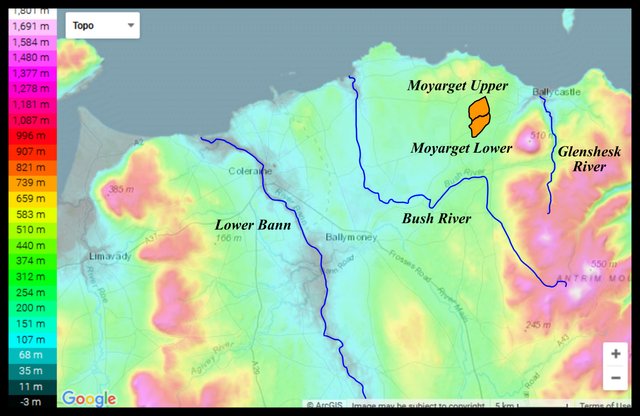
Nevertheless, this toponym lends support to those who would like to identify Ptolemy’s Argita with the River Bush. One of these was T F O’Rahilly, who tentatively identified the Argita with the Bush, having already assigned the River Bann to the next item on Ptolemy’s map, the Vidva:
If Vidva be the Bann, Argita can only be the Bush, in the north of Co. Antrim. The name is probably related to the O. Ir. argat, < *argento-, “silver”. It may be worth recalling that the mythical Fothad Airgthech was connected with Co. Antrim; he is said to have been slain by Caílte in a battle at Ollarba, near Larne. His epithet airgthech [or airgdech] is explained as “wealthy”, and comes from argentākos, a derivative of *argento-, “silver”; but formally airgthech might come equally well, or better, from *argitākos, meaning perhaps “bright”, a derivative of Argitā, (O’Rahilly 6)
In our native records, as O’Rahilly pointed out, the Bann is called Bandae (later Banna), which means goddess. The native name of the Bush derives from the word búas, which simply means stream.
Louis Francis reverted to the earlier identification of Ptolemy’s Argita with Lough Foyle, but added:
... the longitudinal co-ordinate of the second outflow [Argita] would place it more in the vicinity of Ballycastle Bay. (Francis)
The diminutive Glenshesk River has its outflow in Ballycastle Bay, about 20 km east of the Bush, or 6 km southwest of Fair Head.

In recent years, most scholars who have studied Ptolemy’s geography of Ireland have identified the Argita with the River Bann, and I am inclined to agree with them:
Αργιτα river mouth (Argita 2,2,2) was the river Bann through Coleraine, a name based on PIE *arg- “white”, hence Greek αργης “bright, shining” or words for “silver” such as Irish argat or Latin argentum. Celticists have suggested the river’s waters were considered “shining” by local people, but it seems more likely that mariners would have noticed the extensive white sands in an estuary extending well inland in Ptolemy’s day, and now represented by Portstewart Strand and sand dunes. (Romaneranames)
Ptolemy only lists three rivers for the whole of the northern coast, and as it happens, there are only three principal rivers along this stretch of coastline: the Swilly, the Foyle and the Bann. Growing up in Ireland, these were the only rivers in this part of the country that I could put a name to. I first heard of the Bush when I read the passage in O’Rahilly quoted above.
| Bann | Bush | Lough Foyle | Lough Swilly |
|---|---|---|---|
| - | - | - | Camden (1607) |
| - | - | Ware (1654) | - |
| - | - | Lewis (1837) | - |
| Müller (1883) | - | - | - |
| - | - | Martin (1892) | - |
| Orpen (1894) | - | - | - |
| - | O’Rahilly (1946) | - | - |
| - | Byrne & O’Kelly (1984) | - | - |
| Mac an Bhaird (1991-93) | - | - | - |
| - | - | Francis (1994) | - |
| Stempel (2002) | - | - | - |
| Toner (2002) | - | - | - |
| Darcy & Flynn (2008) | - | - | - |
Source: Darcy & Flynn 57
References
- Samuel Lewis, A Topographical Dictionary of Ireland, Volume 2, S Lewis & Co, London (1837)
- William Camden, Britannia: Or A Chorographical Description of Great Britain and Ireland, Together with the Adjacent Islands, Second Edition, Volume 2, Edmund Gibson, London (1722)
- Robert Darcy & William Flynn, Ptolemy’s Map of Ireland: A Modern Decoding, Irish Geography, Volume 41, Number 1, pp 49-69, Geographical Society of Ireland, Taylor and Francis, Routledge, Abingdon (2008)
- Patrick Weston Joyce, The Origin and History of Irish Names of Places, Volume 2, M H Gill & Son, Dublin (1883)
- Charles Trice Martin, The Record Interpreter: A Collection of Abbreviations, Latin Words and Names Used in English Historical Manuscripts and Records, Reeves and Turner, London (1892)
- Karl Wilhelm Ludwig Müller (editor & translator), Klaudiou Ptolemaiou Geographike Hyphegesis (Claudii Ptolemæi Geographia), Volume 1, Alfredo Firmin Didot, Paris (1883)
- Karl Friedrich August Nobbe, Claudii Ptolemaei Geographia, Volume 2, Karl Tauchnitz, Leipzig (1845)
- Thomas F O’Rahilly, Early Irish History and Mythology, Dublin Institute for Advanced Studies, Dublin (1946, 1984)
- Goddard H Orpen, Ptolemy’s Map of Ireland, The Journal of the Royal Society of Antiquaries of Ireland, Volume 4 (Fifth Series), Volume 24 (Consecutive Series), pp 115-128, Dublin (1894)
- Claudius Ptolemaeus, Geography, Biblioteca Apostolica Vaticana, Vat Gr 191, fol 127-172 (Ireland: 138v–139r)
- James Ware, Walter Harris (editor), The Whole Works of Sir James Ware, Volume 2, Walter Harris, Dublin (1745)
- Friedrich Wilhelm Wilberg, Claudii Ptolemaei Geographiae, Libri Octo: Graece et Latine ad Codicum Manu Scriptorum Fidem Edidit Frid. Guil. Wilberg, Essendiae Sumptibus et Typis G.D. Baedeker, Essen (1838)
Image Credits
- Ptolemy’s Map of Ireland: Wikimedia Commons, Nicholaus Germanus (cartographer), Public Domain
- Greek Letters: Wikimedia Commons, Future Perfect at Sunrise (artist), Public Domain
- Topographic Map of the Lower Bann Valley: © ArcGIS, Fair Use
- Estuary of the River Bann: Geograph Ireland, © Kay Atherton, Creative Commons License
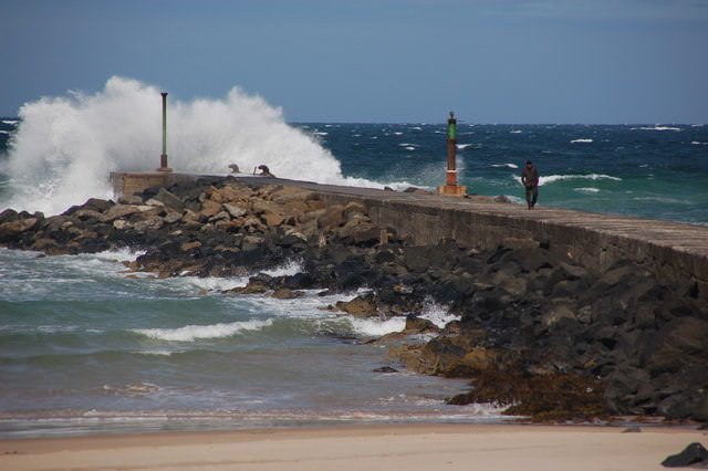
- The Barmouth at the Mouth of the River Bann: Geograph Ireland, © Albert Bridge, Creative Commons License

Excellent post
Posted using Partiko iOS
Hey friend, I am very happy that this is the 20th edition of the Map of Ptolemy of Ireland, congratulations you have done a great job, every time you learn a little more about the history of Ireland, many blessings dear friend and finally, the Rio Bann is very beautiful!
This type of content is very valuable here at Steemit and it is very valuable, you have been uploading very good quality content to Steemit for a long time and I love learning more because I can discuss new topics with my friends, I just have to give them the Thank you.
Excellent and the 20 Map of Ptolemy of Ireland edition very interesting to be able to know Ireland and its history through your post friend thank you beautiful that Rio I would like to know it
Magnificent story friend very beautiful images of those rivers good work you are excellent with your post thank you
One of the countries that I would like to know first is Ireland if I have the opportunity to travel it looks very interesting and nice that great country greetings friend @harlotscurse
hi dear @harlotscurse.. how are you..
hello dear @harlotscurse.. how are you.. i am new to your bolg.. and
Excellent post buddy. Love you