#Club5050 || Bur Kelieten: the purpose of a shoe on a mountain of two peaks

10% Payout to @hive-111293
For support Steem-Travelers Community
”I make shoe contact before eye contact.”
Ever heard that sentence? Maybe yes maybe no. Or maybe you've heard and then just ignored it as something that is not important. But to me, it's a really cool sentence. And if any of you feel that way, I'm sure you guys really love shoes. Even crazy about it.
Yes, I really like shoes, especially boots. I feel that shoes can represent the character and sometimes even the shoes reflect the feelings of the wearer. Yup,
”Shoes speak louder than words.”
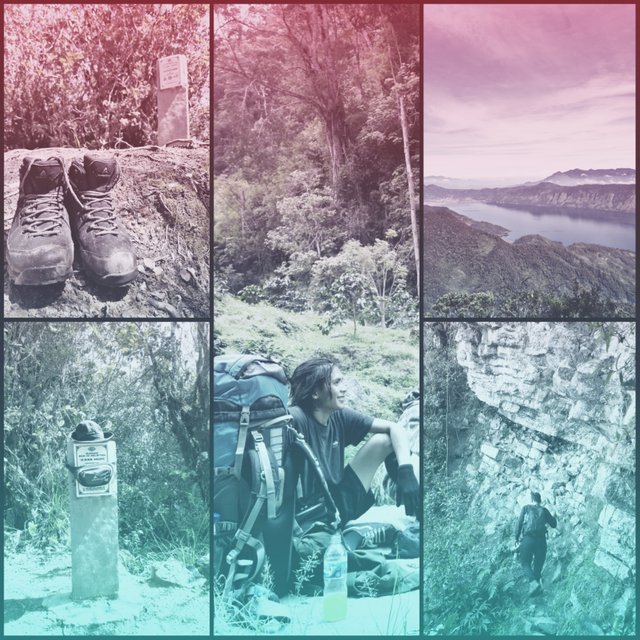
I have one that I really like. A pair of outdoor shoes from a domestic manufacturer whose brand reflects its toughness. Eiger Cayman Lite. Designed for hiking activities as well as daily activities. And I use it to go to work in an office where you basically need to wear shiny loafers. I really don't care about the rules, I'm really very comfortable wearing these shoes.
However, I feel hurt this shoe if it does not complete the function of its creation. I feel that hiking boots will feel sad if they are never used for hiking activities. I feel a shoe as tough as this would be very imprisoned if it had never been touched by rocks or mud on the slopes of the mountain. I feel that kind of pain. I feel responsible and have to help this shoe to complete its creation mission.
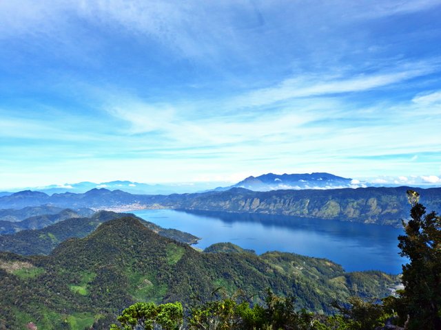
So I decided to do it. We're going to the top of Bur Kelieten. The highest peak in Tanoh Gayo.
Towering high and hiding behind the clouds, Bur Kelieten is southeast of Lake Lut Tawar, Takengon. Not as popular as its brother Mount Burni Telong, Bur Kelieten is famous for its ruthless trails that are so difficult to conquer, that not many people look up there. But for me, Bur Kelieten is worth climbing with these Eiger Cayman Lite shoes.
We moved from lhokseumawe and headed to the village of Mengaya, Bintang District, Takengon. Mengaya village is one of the starting points for climbing villages and Bintang is a sub-district on the shores of Lake Lut Tawar, Central Aceh, which is about 45 minutes from the center of Takengon City. From Lhokseumawe to the initial location of the ascent is about 140 KM with a travel time of about 40 hours.In Mengaya Village there is no post as a place to register for climbing. Even in several other villages that can also be used as starting points for climbing, there is no registration post. This is because not many climbers are interested in this mountain. And for climbers who want to climb Bur Kelieten usually only report to the village head and pay some money to local youths in exchange for keeping the vehicle we parked.
The first thing that becomes mandatory for climbing Bur Kelieten is to stay in touch with the village head and local youth leaders. After getting the blessing, the ascent can begin.
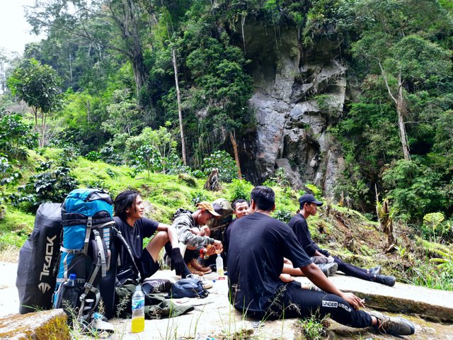
We started our hike when the sun was tilting to the west. About two hours before sunset. The sky is still clear to see the panorama of the coffee plantation owned by the residents. But the track has felt steep and climbing since the beginning of the first ascent. Residents who passed by us could see their footsteps were heavy along the steep hilly path. There was a smile between us and the residents, greeting each other and praying for the safety of our journey. They are very friendly.
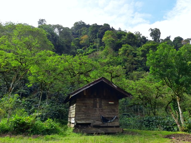
A hut is seen standing firmly in the middle of a coffee plantation. Huts like this are usually used for resting, storing gardening tools, or sometimes being used for the night. I think I should try living in this shack just camping and doing activities with coffee farmers. But not now, maybe next time.
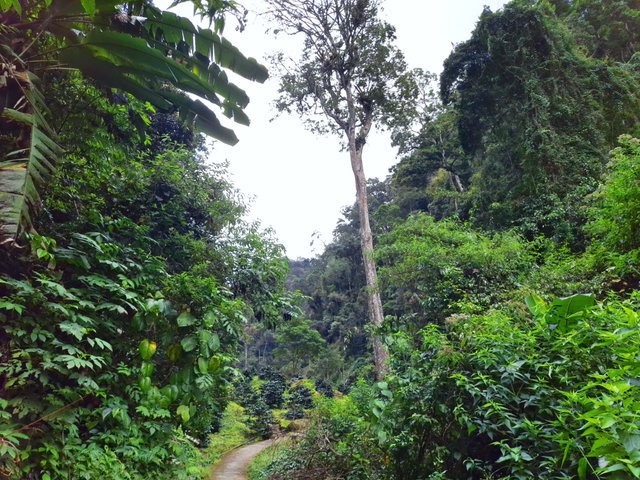
The tracks in the residents' gardens can be passed easily. Footprints used by residents can be used as road markers. Before entering the forest and leaving the coffee plantation, we took some time to rest.
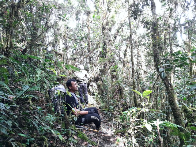
When starting to enter the forest, there is no longer a path that can be used as a guide. And because this mountain is not climbed much, it is very difficult to find traces that have been traversed. But we have to thank anyone who does good things. If you look closely, there are small ties of colored rope tied to the trees along the hiking trail. And when we started to hesitate, we just had to look for the sign and then continue our ascent.
The temperature was getting colder when we arrived in the wilderness. Every time we spoke there was steam coming out of our mouths. Some of the friends were even seen smoking over their shoulders and heads. The sky was still bright at that time. But the atmosphere became very quiet. The only sound we could hear was our footsteps.
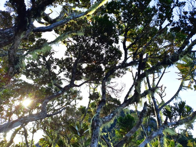
This forest is very natural. I didn't find a single tree that had been cut down. Everything is very green with large trees that limit our view of the blue sky. The roots of certain types of trees seem to come out of the ground and appear on the surface. There are also extra-large trees such as sticking out from behind their tall leaves and branches. Thick and green moss covered the trunk of a large tree. There is also a tree that is very large and fallen but still alive, and supports other small trees on it.
For a moment I thought, we are not yet at the top, still half way through. And I have been flabbergasted by this kind of beauty. It is very unfortunate if this forest is cut down to meet the needs of human life. I really hope that our future generations will still have the opportunity to see the pristine forests.
The silence seemed to confirm that we were the only ones crossing this forest. the absence of a voice other than we also support that the assumption is true. But as a rational creature of God, my mind refutes that assumption. There are many living things that make this forest their habitat. And of course most of them are predatory animals that I really don't want to meet on this momment.
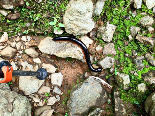
I am very grateful, most of what I met while in the middle of the forest were good things and extraordinary beauty. One that is very unique is the millipede. Interestingly, this animal is very jumbo in size. Usually the millipedes that I often see are only the size of a cellphone charger cable and the length is the size of an index finger, this millipede is very large. Its body size is not much different from the size of the trekking pole with a length of half the length of the trekking pole.
When the sky was getting darker, and the forest was starting to get bustling with the sound of small animals as a sign that it was going to be night soon, we rushed to shelter 3, the shelter where we camped. This place is very different from all the places we could find on our travels. Like a small field. Quite flat and spacious. It is perfect for camping, enjoying dinner in the forest, and spending the night by a campfire.
Mountain climbing is the art of self-harm. I agree. When I got home, dinner was already prepared and all I had to do was eat it. But here, we have to cook ourselves. If in town and want to enjoy a cup of coffee, we just need to go to a coffee shop and order it. But here we have to boil the water first and then brew the coffee ourselves. Sleep is the same, we can sleep on a soft mattress when we are at home. But here, our backs are only separated by a thin mattress so they don't touch the earth directly when we sleep. Truly the art of self-harm.
But in fact, apart from enjoying the top of the mountain, and enjoying the journey. We really enjoyed the trouble of ourselves. I can't explain it scientifically, or even I won't be able to get people to understand what it means. Maybe humans have a tendency to do something out of the ordinary. Or maybe humans need something to get their adrenaline pumping. Or, or, I don't know. forget it.
The climb continued after breakfast, and we had a fairly short rest. But enough. There is no target to see the sun rise from the top. Not this time. So we don't have to rush in the middle of the dark to climb to the top.
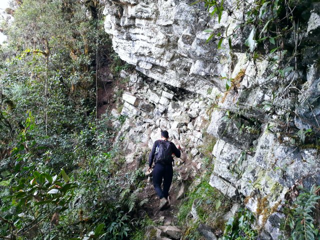
The journey to the top passes through a very steep, but dry track. Our feet don't have to be covered in mud this time. Even so, the potential danger did not decrease in the slightest. We still have to be careful every step we take. Most of the tracks are rock walls and huge cliffs that look very easy to collapse.
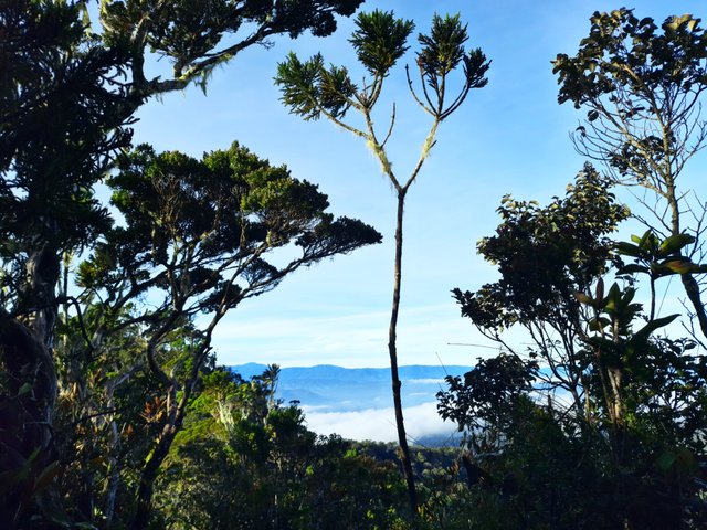
From behind the leaves that are not too dense, the blue sky and white clouds can be seen faintly. Quite beautiful. The signs of approaching the peak are increasingly felt.
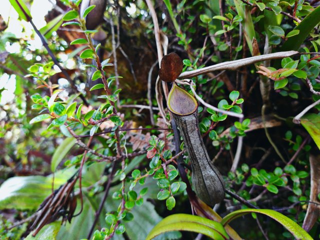
Thick green moss dominates the uniqueness of the forest towards the peak. At first glance, the moss looks like someone is taking care of it, like a terrarium in a luxury aquarium. Some of the wood trees are overgrown with very beautiful orchids, also rare. With very attractive colors. One of the most unique and interesting is the Kantong Semar. Judging from its shape, it looks like a cute and adorable plant, but this plant is a carnivorous insect-eating plant.
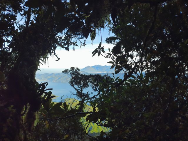
It is often said that Mount Bur Kelieten has two peaks. The first peak is called the rock peak. From this peak climbers can see with a very broad view. The entirety of Takengon City and Lake Lut Tawar can be seen from here. While the other peak is the actual peak. The peak where the highest point of this mountain is located.
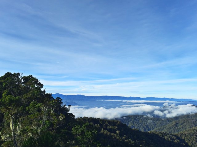
When we arrived at the top of the rock, we only took the time to rest for a bit and take some photos as documentation. The sky is clear enough to get a very beautiful view from the top of this rock. But we were unlucky because we didn't see a cloud that was parading near the top of the rock. And if you are lucky, there are usually clumps of clouds very close to the top of the rock. Because the top of this rock is a cliff-shaped mountain wall. So when a cloud approaches it, it's often too close to touch by hand.
The distance from the top of the Rock to the highest Peak is not too far away. It only takes a few minutes to get there. However, because it had been a long hike, we took one chance to rest.
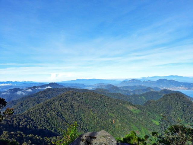
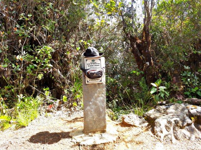
The true peak of Bur Kelieten is often referred to as the peak of the pillars. Because there was built a monument, or pillar as a marker of the identity of the mountain. And when I reached the highest peak of this mountain, the point with an altitude of 2,639 meters above sea level, I had completed my duty in terms of helping these shoes carry out their mission.
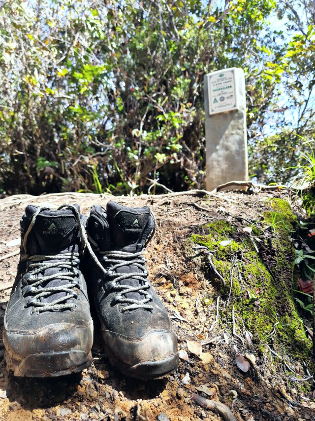
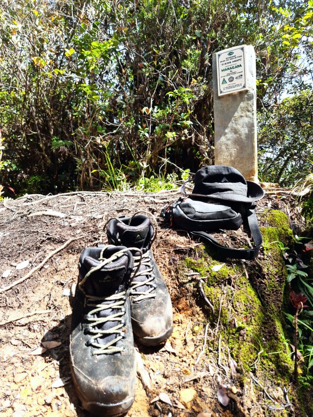
The Eiger Cayman Lite shoe has reached the highest peak in Central Aceh. And I don't have to feel guilty anymore if I go to work tomorrow and wear these shoes instead of loafers.
Thanks for being my reader.
Love you guys.
Special Thanks to:
@pennsif | @hive-111293 | @papi.mati
@willeusz | @ponpase | @udyliciouz
Best Regard,
@rlenze
Great job!
Your high-quality post has been upvoted by the Lifestyle curator team managed by @willeusz We enjoyed reading it a lot.
Follow @steemitblog to update the latest information about Steemit.
Thanks for taking the time to read and appreciate my post. I'm so glade for that. Especially upvoted from you guys @steemcurator06 @willeusz