The Geopolitical Impact of the Discovery of Ancient Dwarka
As was discussed in Dwarka: The Lost City of Krishna, there is very compelling evidence that the ancient city of Dwarka existed and was precisely in this location:
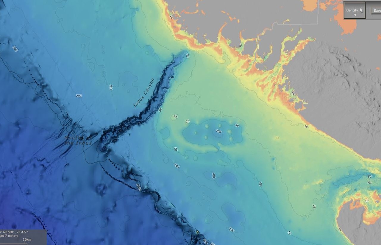

Source Link, bathymetric map with DEM Color Shaded Relief
Not that long ago, Muslims and Hindus lived jointly in the lands that are known today as India and Pakistan. During World War II, in 1947 the British left the land that they had occupied as a colony due to the war.

The departure was rapid, occurring with a year's notice. As unrest and disarray settled in, with Muslims and Hindu killing one another on sight, it was decided to partition the land. Muslims were placed in the western region where they mostly occupied and with more Islamic religious sites, while Hindus were placed in the eastern region. This led to 10 to 20 million people being displaced by the partition according to religious lines.
Hundreds of thousands, if not millions, of people lost their lives from the violence and disorder. The cultures were intermixed and the partitioning could not be done with any degree of absolute precision. A single individual was assigned the task to equitably divide, now known as the Radcliffe Line.
And then the countries were separated.
This was, of course, not able to be done with any amount of reasonable calm. Punjab and Kashmir have since been hotbeds for tension between the two countries. Several decades later, the two countries are now nuclear armed and preparing for confrontation with one another.
While the residential and historically significant regions of border dispute have gotten the most attention, still unsettled as well is the Sir Creek Dispute.
As the border's path enters into the marshlands nearing the Arabian Sea, it is within a 96-km tidal estuary of uninhabited marshlands of the Indus River Delta. Here, dispute of the border arises once more. The border leading up to Sir Creek are accepted by both countries, but Pakistan claims they believe the border should be drawn along the Indian side of Sir Creek, effectively giving Pakistan the creek, whereas India believes the border should be drawn down the middle of the creek, as is commonly done in accordance with international law of the thalweg principle.
However, the creek's center is difficult to distinguish, as the creek has changed its course considerably over the years. If the boundary were to be demarcated according to the thalweg principle, it would only match a moment in time. Neither side is willing to accept the other's in the dispute, given the circumstances of the marshlands.
Though the creek has little immediate value to either country, it allows for large economic gain. Control over the creek would have a bearing on the defined boundaries of the Arabian Sea, which help determine the limits of each country's exclusive economic zone (EEZ) and continental shelves. Each country sees that the region is rich in oil and gas below the sea bed, and the boundary would allow or restrict access.

And so, wouldn't you know, Ancient Dwarka--by no mere coincidence but by the Will of God--is smack dab in the region of dispute. Neither country has noticed, or the dispute would not be so casual.

Pakistan's exclusive economic zone, as agreed upon by India's thalweg principle approach of Sir Creek, includes portions of the seabed where Ancient Dwarka resided.
And fanning outward, as if meant to sweep across it from the dispute between the two nuclear armed powers, the grey area between the two defined regions puts Dwarka at the heart of the conflict.
Ancient Dwarka has been said to be found before. Always the evidence is of stones. Never have gold, silver, gems, and crystals been found in construction. Yet, this is what Ancient Dwarka is described as. Indeed, it is said to have existed on six blocks and on a lake. The name Dwarka means "gate" or "gateway" or even "gateway to heaven." The likelihood of an anomaly as clear as seen in the bathymetric data without it being the actual location is extremely small.
And so, if this is indeed Ancient Dwarka, at first glance it could perhaps spark a nuclear war between the countries. However, it is important to recognize that it would be actual tangible proof of the historical record of Hindu scripture, if these building materials were to be found at the location. It is an opportunity for people of Islamic background in the region to appreciate the validity and merit of the Hindu scriptures and mend the division that was caused by the separation. And, for India to help the Pakistani people by working together.
Pakistan has been viewed by the world as of very little value. Countries are unwilling to trade because Pakistan has so little to offer in terms of trade. This has ramifications in that the people of Pakistan are extremely poverty stricken, with little to no water and food. It will be imperative for India to recognize the blight that the Pakistani people have been put through. Dwarka is not India's. It does not change anything. This is a life lesson for the world manifesting.
The Sir Creek Dispute demonstrates the country of India made no adamant effort to obtain the region of ancient Dwarka as being definitively part of India's controlled territory. Therefore, it is unjust of India to in any way change its position as a result of this new information. While on the surface it may appear that the Hindu site is "theirs", the country of India was formed in 1947.
It is of paramount importance that India shares this discovery with neighboring Pakistan and works together. After all, it was Al-Mahdi who discovered ancient Dwarka.
For more information, read: Ancient Dwarka: Tales in the Land.