The role of geology in the Allied invasions in Normandy
When allied forces planned to land on the coast of France, they carefully approached coastal geological studies. More than a million air photographers on light aircraft fly over the coastline to find the best place to invade and open the western front against Nazi Germany.
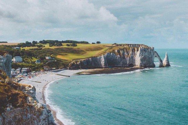
The most likely point is a small area with sand washed between the ports of Le Havre and Cherbourg, as it will make it easy to drive ashore to amphibious machines. In 1944, many British divers risked their lives swimming near these shores and collected rock samples so geologists then determined whether sandy beaches could withstand the heavy equipment and modified tanks necessary to capture the coastal fortress of Germany.
On June 6, 1944, Allied forces in the number of more than 156,000 people landed on the coast of Normandy with a length of 850 kilometers. On the first day due to bloody fighting, about 10,000 people were killed, of which 4,000 were soldiers from Allied forces.
Already in our day the geologists Earl F. Mac Brid and M. Dine Picard, amateurs collect sand samples around the world, exploring the coast of Omaha - the code of the name of one of the sections of the beach where Allied landings take place. The grains they find exactly match the rocks in the nearby area and the drainage river basin. Basically, they meet quartz grains, feldspar, limestone and fragmented shells.
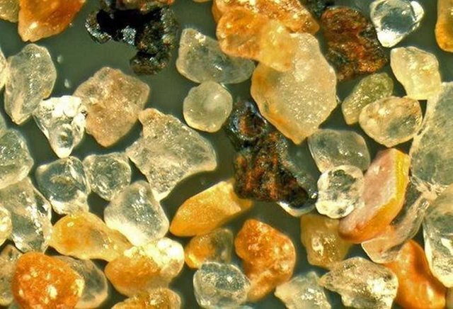
Observing the samples, geologists also found magnetic grains and small balls of metal and glass. All metal particles are actually the remains of a shell's shell, and the glass comes from melted ammunition. In 2013, two famous artists along with a team of volunteers use these grains to make a memorial to honor the fallen soldiers.
Allied troops landing accompanied by strong air bombardment to withstand artillery fire from German coastal units. A very strategic place is considered Pointe Du-Oak - a small rocky peninsula, from which a beautiful view of Omaha beach. It is still possible to find a mini crater of bombs and grenades. When geologists discover the remains of tiny fossils on the ground, traces of military operations, they even come with special terms to make them easier to classify and not to be confused with other rocks. These metal and molten glass balls will be on the beach for hundreds of years and even thousands of years until they are completely washed by the waves of the oceans.
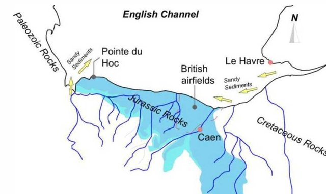
Simple geological map from the beach
Coastal geology of Normandy played an important role in the success of the military invasion. The site near the beach, located north of the city of Kan, was formed by Jurassic limestone more than 200 million years ago and closed about 20,000 years ago by sedimentary rocks that carry rivers from the mainland. Formed for a long time, flat and dry land has become an important strategic place for the opening of a military airfield for equipment originating in the UK.
After a successful invasion, geologists began searching for powerful stones that could be used for construction work. Later, wells drilled into the aquifers helped supply troops with clean and fresh drinking water. 11 weeks after the landing of British troops, Paris was released, and a year later, the Second World War ended.
You received a 10.0% upvote since you are not yet a member of geopolis and wrote in the category of "geology".
To read more about us and what we do, click here.
https://steemit.com/geopolis/@geopolis/geopolis-the-community-for-global-sciences-update-4
So, what is any gift which is be denied more?