Site Formation Processes in the Context of Maritime Archaeological Landscapes
Site Formation Processes in the Context of Maritime Archaeological Landscapes
Abstract
Analogous to the attainment of a complete historical picture of a site is the importance of understanding the processes that happen to a site or to an assemblage after deposition. Archaeologists can only draw upon what the archaeological evidence tells us. Therefore, incorrect interpretations of a site can occur due to a lack of recognition of its post depositional processes or site formation processes. In the Maritime context, site formation processes is a slightly newer topic than it is for our terrestrial cousins. Indubitably, site formation processes differ under the water than on land. As well as providing some examples of the different types of maritime site formation processes, and highlighting two case studies (Kalambo Falls B5 and Heracleion-Thonis) that were notoriously complex and difficult to understand – This paper also underlines the importance of understanding site formation processes as imperative to a sound interpretation of a maritime site.
In the years following the beginning of the 1970’s, many archaeologists had become familiar with the taphonomy of archaeological finds and had to come to understand the idea that a series of formation processes may have affected an artifacts archaeological signature, including the types of processes that occurred after they were buried. Schiffer (1972) is generally acknowledged as the archaeologist who first started to think about, and then go on to formulate, a coherent model. Later that decade, and in the maritime context, Muckelroy (1978) became the first maritime archaeologist to think about site formation processes under the water. Site formation processes can be broken down into two categories: cultural site formation processes (C-transforms) and natural site formation processes (N-transforms) (Catling 2009:112). C-transforms can be viewed as human, accidental or deliberate, activities that might affect the way we perceive artifacts. For example, a farmer plowing their field involves a process whereby the soil from lower layers are percolated up into higher layers and artifacts may thusly be found in higher soil strata and interpreted as younger than their real age. N-transforms, on the other hand, are nature’s involvement in the burial of artifacts (Renfrew and Bahn 2012:54). For example, the gradual burial of artifacts by soil moved around by the wind or the chewing of a bone by an animal (Renfrew and Bahn 2012:53). The understanding of these processes is fundamental to the meticulous archaeological reconstruction of the past.
This paper highlights two maritime case studies; the first concerning coastal site formation processes at Thonis-Heracleion, and the second – a mainland-based site at Kalamnbo Falls B5. At first glance mainland-based site formation processes do not appear to be ‘maritime’. However, Muckelroy’s (1978) description and inclusion of riverine and lake areas as inherently maritime, prompted the necessity to highlight the sometimes forgotten casualty of N-transforms - social context.
Case study 1 explores a geological analysis of Kalambo Falls B5 that highlights a socially context-less and unique site, especially in its categorisation as maritime. Case study 2 looks at the port towns of Thonis-Heracleion and East Canopus, via a geological and geoarchaeological analysis; in order to illuminate the site formation processes occurring in and around that region of the Mediterranean. I will then cast an eye at how the changes in landscape affect the settlement and social life of Thonis-Heracleion. After all, akin to Binford’s (1981) critique of Schiffer’s transforms, the main aim in explaining the pre and post depositional processes that occur should be to uncover the link that connects behavioural forming processes. Therefore, by understanding the site formation processes we can better understand the social behaviour that occurs after it - for example, the maintenance dredging of many of todays shipping lanes in South Asia creates sedimentation of sea-bottoms, thus reducing the feeding areas of local species of fish. This has meant that many fisheries have been forced to relocate because of sedimentation. So it is that changes in landscape play a role in explaining social behaviours.
N-transforms
The environment and its subsequent natural formation process are fundamental to archaeological research because it affects the survival of sites left behind by the, sometimes, non-informative cloud of linear time. Much of the past is studied as a reaction to site formation processes, both natural and cultural, and are vital components before human activities and interpretations of archaeological remains can be explained in a rational and scientific way (Bowens 2009:28).
Once the environment shapes activities in the past, it then shapes how evidence of the past survives, which can vary from simple chemical changes in the soil to erosion by saline water (sea) or fluvial processes. It is very possible that cultural material could move into the archaeological record from occupied sites in locales prone to flooding, seismic activity or volcanic discharge, in a very different way from cultural material in stable and temperate zones. In the marine environment context, deposition by abandonment, caused by rising sea level or sediment subsidence, will in most cases take place over a longer period of time, as opposed to the ephemeral but fierce processes of a shipwreck (Martin 2011:7). Logically, this will mean that less material is eventually deposited, as the inhabitants will have a longer period of time to remove what they want before abandonment. However, because the process of inundation is much gentler than the process of shipwreck, more cultural material will remain taphonomically near to actual areas of use rather than scattered along the seabed, as is the case with shipwrecks (Martin 2011:8). Gradual inundation does not usually result in great preservation. The repetitive nature of pounding surf and alternating periods of wetness and dryness, weather sites that have been submerged slowly. Indeed, both of these conditions can damage or destroy material. Even if artifacts themselves are preserved, their spatial context will often be destroyed.
Sites located on steep inclines tend to subside gradually, as the gradient of the slope holds back rising water (Gifford, 1990:115). This was likely the case at the Neolithic settlement of Agios Petros, in the Northern Sporades islands, Greece. Agios Petros was inhabited from approximately 5000 to 4000 B.C.; its existence was probably related to maritime activities such as fishing (Flemming, 1985:140). The village was situated on a slope with an angle of approximately 14°, just above a natural harbor. The incline of the slope seems to have resulted in only a slow submergence of the village as sea levels rose over the past 5000 years (Gifford, 1990:111). Gradual subsidence allowed waves to erode artifacts out of their original positions and deposit them farther downslope. Flemming (1985:140) notes that many of the artifacts show little abrasion from the waves. Despite the good preservation of the artifacts themselves, however, it is probable that their original spatial context has been destroyed. On the other hand, evidence indicates that rapid submergence of a site, followed quickly by burial in sediment, preserves artifacts and their spatial patterning better than gradual inundation. Tectonically, rapid submergence can be caused by mechanisms such as earthquakes. On June 7, 1692, a massive earthquake struck the British colonial city of Port Royal, Jamaica. In a matter of minutes, two-thirds of the city slid into the harbor and sank beneath the waves. Over 2000 people lost their lives in the cataclysm. Excavation of the sunken city in the 1980s revealed substantial damage caused by the earthquake. Preservation of artifacts, however, was very good, at least in part because much material was buried beneath collapsed walls. Contextual relationships within the site were preserved as well. The excavators were able to determine the functions of particular rooms, and in some cases activity areas within rooms, by the patterns of artifacts (Hamilton and Woodward, 1984:44). Historically, tectonic movements have always been recorded. The Roman colonisation of Corinth (44 BC) was well documented by Strabo, who attests to the large-scale works on reconstructing the harbour, The harbour had to be rebuilt because of the tectonic action that the region was renowned for. Roman historians Quintus Curtius (AD 41-79) and Gaius Suetonius (AD 69-122), and the Byzantine chronicler Ioannis Malalas (AD 491-578), documented the various seismic activities taking place at different epochs of time upon Roman Corinth.
Mourtzas et al. (2014) found indicators of historical sea level change at Corinth, including: beach rocks, fossilised submerged and uplifted marine notches, marine erosion forms of the intertidal zone and ancient coastal harbour installations. The sea level during the Roman operation of the harbour was 0.90mm lower than the present. This functional level is in agreement with the predicted sea level of the ‘glacio-hydro-isostatic and eustatically corrected model’ of Holocene relative sea level for the Peloponnesus developed by Lambeck and Purcell (2005:34). According to the glacial isostatic adjustment model for late Holocene presented by Evelpidou et al. (2012a), the relative sea level at Lechaion is estimated c. 0.45m lower than the present sea level. After the Roman reconstruction of the outer harbour and its renovation in AD 358, which was followed by the abandonment and siltation of the ancient harbour installations, Mourtzas et al. (2014) noted three vertical co-seismic tectonic events that seem to have caused the sea level fluctuation. The severe earthquakes of the period AD 362-375, which hit the area causing the elevation of the northern coast of the Gulf of Lechaion and the submergence of the western coast of the Saronic Gulf, are probably the beginning of these recent sea level fluctuations and the initial subsidence of the south coast of the Gulf. The earthquakes between AD 522 and AD 580 which caused extensive destructions in the area of Corinth, is very likely to be linked with the second vertical tectonic subsidence of the coast of Lechaion, all of which means the sea level at this port changed a dramatic four times due to seismic activity (see Fig.1).
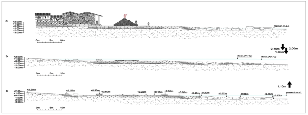
Figure 1 – Cross section of the western mole. (A) The sea level in Roman times was 0.90m lower than the present (B) After abandonment of the foreharbour and the siltation of its facilities, the area is submerged in two tectonic subsidence events and sea level rose by 2.0m in total. During the first event, the mean sea level rose by 1.60m and during the second one by 0.40m. (C) A strong tectonic uplift event followed and sea level dropped by 1.10m (taken from Mourtzas et al. 2014:163)
Case study 1 – Geological Analysis of an Acheulean Site at Kalambo Falls, Zambia
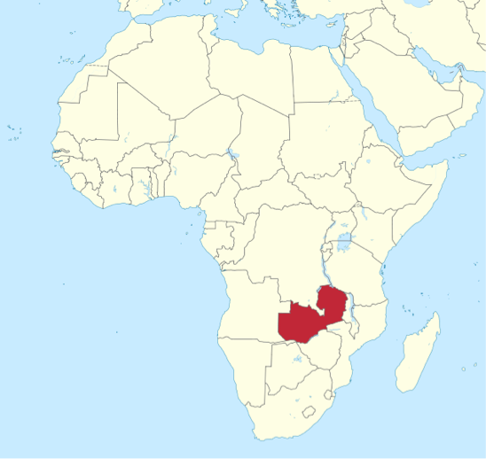
Figure 2 – Highlighted region of Zambia (in red) within a map of Africa. Zambia is roughly 1000 miles away from the nearest coastline and far removed from the stereotyped view of maritime archaeology. Maritime cultures have flourished and inhabited these wetland regions for millennia. As much as Zambia is a land-locked country, it of course cannot escape the history erasing mechanisms of N-transforms.
Gradual subsidence by eustasy (sea rise) at Neolithic Agios Petros, rapid subsidence by tectonic displacement at Port Royal and Corinth harbour, and isostasy; these are all sites with obvious, and sometimes, event laden N-transforms, occurring during epochs of high civilisation that could record in writing what was happening and therefore make our jobs as archaeologists easier when unraveling a site. Understanding the processes of these N-transforms is essential if one wants to solve the mind-skewing puzzle that is an archaeological site after its signature has been smudged by site formation processes, such as the site of Kalambo Falls B5.
The site of Kalambo Falls confused many – an Acheulean site generally contained large numbers of bifacial tools, for example, hand axes, cleavers, knives and picks. At this site however, all of the artifacts were found in one locale as stone clasts, undoubtedly allowing for incorrect interpretations of the culture that lived at the site. How is it that all of the artifacts are found in one locale and what site formation processes affect what we inevitably encounter as the end product of these processes?
Isaac (1975:512) describes the three main characteristics of Acheulean sites: a) large quantities of artifacts, b) high spatial densities, and c) large bifacial tools. The questions these characteristics provoke include: what role did C-transforms play in terms of human, but most likely, hominid behaviours, if any. Are these large concentrations of artifacts representative of Homo erectus localisation? Or was that same locale used over an extended period of time by later Homo erectus groups or even Homo sapien groups and thusly explains the density of artifacts? If so, we would have to start looking into special discard practices to explain why all the tools had been discarded in one locale. Schick (1992) asks an even more pertinent question: are the site configurations solely explainable by cultural processes? Or have N-transform processes affected the site?
The Kalambo Falls B5 site itself is located within a sedimentary basin shared with three other sites A, C and D (see Fig.3). The spillway gorge controls the local base level and 100m upstream from the falls one can find the Kalambo sites. The excavation of site B5 is an extension of previous sites, B1 (1956) and B2 (1959) and connects the three trenches at an Acheulean level about 5m below the surface. There are of course many sedimentary layers before arriving at the Acheulean level and it is interesting to note that many Acheulean artifacts were lying on a pebble line horizon. Under the Acheulean horizon is a layer of
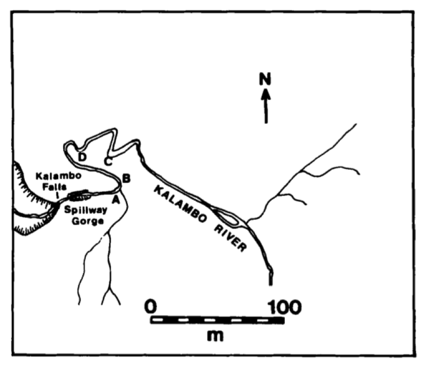
Figure 3 - Location of Kalambo Falls sites (A, B, C and D). (Taken from Schick 1992:8 and originally drawn by Clarke, 1969, fig.2)
white-bedded fine coarse sands with gravel and pebble stringers. The contact point of these two lithologically separate sandy beds marks the point where large clasts have been deposited. The condition of the artifacts are generally thought of as fresh which would indicate that fluvial transport of the artifacts definitely did take place, but was not a prolonged affair.
Another reason to suggest fluvial processes were involved in making this site what it is today, is the pattern representing flakes and fragments. The majority size of flakes and fragments found at B5 are between 4-8cm, but flakes smaller than this should be present in abundance if the hominids were flaking at the site, which they are not. Therefore either the hominids brought the flakes to the site but only the 4-8cm sized flakes (see fig.4) and did nothing with them thereafter or, the more likely causal effect, fluvial sorting took place.
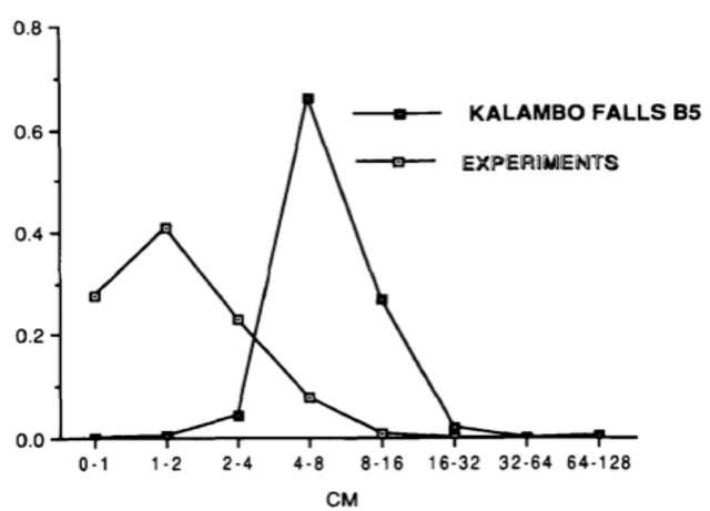
Figure 4 - Flake size distribution experiment. Kalambo falls (n=364) compared to Oldowan/Acheulean artifact replication experiments (n=5931) (Taken from Schick 1992:14)
The orientation of the assemblage of artifacts (see Fig.5) can be seen as another piece of evidence to suggest that N-transforms occurred here. A strong East to West orientation was present among the artifacts. According to Schick (1992), this indicates a flow pattern roughly in a north-south axis, and further, heavier lithic pieces tend to be oriented with the heavier end toward the east because the heavier end of elongated pieces usually traverse the outside of a bend in a stream. Allen (1970:131) explains this as “radial pressure set up on the bed of a channel going around a bend which results in the flow following a helical path across the surface of the water to the outer bank and then down across the bed downstream toward the inner bank”. Also the same orientation can be found at site A4, which is situated 300m downstream from B5 (see Fig.3).
It is entirely likely that a stream traversing on a north-south axis periodically dammed the Spillway Gorge with sediment and evidently spilled into the basin from the south. Of course, it is impossible to know whether tectonic movements affected the drainage of the stream. Did it completely drain in the Kalambo River or had tectonic movement taken place meaning that the Kawa River also shared this drainage? Schick ultimately admits that it is impossible to know this.
We must accept that in all likelihood human behaviour played a small role in assemblages found at B5. The part they played, however, was by no means insignificant. There was human activity in the catchment area of the River, as evidenced by the flake debris, which allowed the fluvial flows to deposit the lithic assemblages at B5. But ultimately, it is fluvial processes that have created the large artifact density at the site as we know it today. The conjunction of partial fluvial processes and partial sedimentary processes played an immense role in producing this Acheulean This process has swept away the spatial and site patterned clues to social life at that time.

Figure 5 - Plan of artifacts Acheulean “Occupation Floor V” at Kalambo Falls site B5. Rose diagram indicates preferred orientation of elongate artifacts. (Taken from Schick 1992:11)
Case study 2 – Geoarchaeology at Thonis-Heracleion
Kalambo Falls B5 represents a complex archaeological signature with a false systemic context personified in an assemblage. On the other hand, Thonis-Heracleion represents a complex systemic context, which can make the archaeological signature harder to read because of C-transforms. Heracleion, along with another important site; East Canopus, were located on the Mediterranean coast of Egypt along Egypt’s north-western Nile delta, now submerged in Aboukir Bay, at depths of between 5 – 7.5m (Goddio 2007). Both sites served as the first transit port on route towards the Hellenised trading center of Naukratis from about 570 BC (Stanley, Schepp, Goddio & Jorstad 2004:5) but Thonis-Heracleion was much more important. According to Goddio, Robinson and Fabre (2015) the growth of this city owed to three factors: the ability for the city to create a port within the constraints of the region’s environmental disability to create a port, the demand for a port (which arrived with the new political powers attached to the northwestern Delta in Egypt during the Late Period), and the need to tap into the market of the Greek world.
In ancient times, the Nile, as it entered the Delta towards the Mediterranean, split into seven branches, the western most of which was called the Canopic branch (Stanley et al. 2007:2). Thonis-Heracleion was located at the silty mouth of the Canopic. Special sets of natural formation processes occurred, and still occur in modern times, around this region of the annually flooded Nile delta.
Over the last fourteen Millennia (well into the Quaternary Age), the north-western Nile delta margin has gradually evolved on top of a geological terrain called the North Delta Block (NDB). The NDB is tectonically lower than the Nile delta terrain to the south (Stanley et al. 2007:49), and is comprised of nearly 5000m of ‘partially to well-consolidated’ strata made up of mostly sediment-based carbonates (Hussein and Abdallah 2001) (See Fig.6). In simpler terms, if the Nile never flooded its branches with fine silts and sediment that spilled out of the mouth and into the region between Aboukir Bay and Port Said, the shore line of the delta region would be located at a much more receded level than is currently measured (see Fig.7).
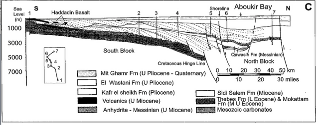
Figure 6 – South-north transect across the Nile delta margin, highlighting the major stratigraphic and structural configuration, including the graben-like basin underlying Quaternary units in Aboukir Bay (Taken from Stanley et al. 2007:25)
However, flooding and sedimentation are not the only factors attributing to the soluble seabed of Aboukir Bay; tectonic activity has also played its part (Stanley 1997). The average rate of land subsidence in that region, calculated by radiocarbon dated sediment core data (Stanley et al. 1996), and taking into account worldwide changes in sea level and regional lowering of land, is roughly 0.1mm/year. However, to the east of Aboukir Bay, i.e. northeast Nile delta, we see that number rise to 5.0mm/year (Stanley and Warne 1998). In this low lying tectonic sedimentary context, the Canopic branch of antiquity deposited Nile silts until the point of channel clogging, therefore reducing the Canopic branch to not much more than a muddy stream. The mouth of the Canopic was the first part of the branch to be silted and was also the branch that connected Thonis-Heracleion with Naukratis and the Nile.
Scholars now believe this, as well as the N-transforms mentioned previously, may be because of C-transforms; the digging of the Alexandria canal, south of the mouth of the Canopic, diverted fluvial water that at one time reached the mouth, and thus diminishing the Canopic flow velocity. Another general example of how the impact of human agency can also create significant fluvial changes, and possibly affected the Delta region, can be seen in the realm of agriculture, which can silt up rivers because of the sedimentary run-off from farmlands.
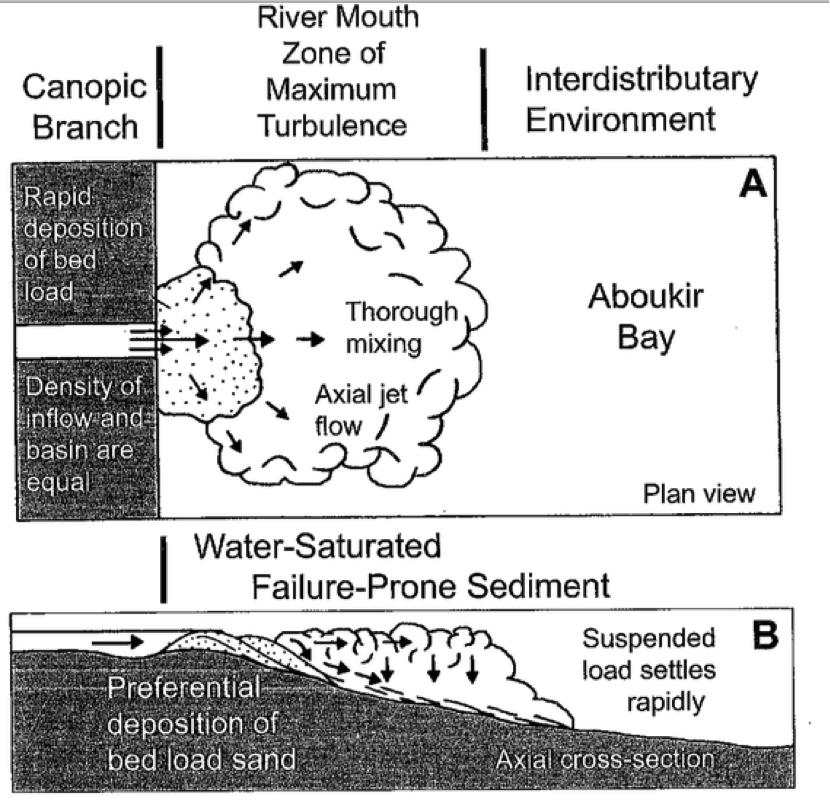
Figure 7 – (A) Schematic showing hydraulic conditions, axial jet flow and sediment discharge at a river mouth under normal outflow conditions into a standing body of water such as Aboukir Bay. (B) Diagram (axial cross-section) of similar flow conditions, showing deposition of sand bed load at and just beyond river mouth, and rapid release and accumulation of finer-grained, water-saturated sediment somewhat farther basinward (taken from Stanley et al. 2007:49)
Moreover, it is quite probable that subsidence at Heracleion and East Canopus was further enhanced as a result of heavy structures, such as temples and other constructions, built directly upon the soft mud substrate (Stanley et al. 2007:54). In short, the N-transforms that effectively submerged the two ancient trading port sites were as follows: rapid accumulation of water saturated sediment, which eventually led to episodic sediment failure at the Canopic mouths, by way of over-steepening. Some other, but perhaps less influential, N-transforms include tectonic subsidence and heavy annual Nile flooding, which caused sudden additional loading on already unstable deposits. Other site formation processes that helped the submergence of the two sites include C-transforms; specifically the overloading of weight by a process of building heavy structures upon the weak sediment and also the divergence of fluvial velocity, in the most part, due to the digging of the Alexandria canal, the new trading link to the Greek world. Indeed, all of the aforementioned formation processes occurred at a gradual rate and not via a single catastrophic event (Goddio 2007). It is important to note, however, that seismic activity and gradual sea level change also played their parts, as additional site formation processes, although not a major role. Seismic activity has a very detrimental effect on foundations built in relatively soft strata because of the movement that invites faults to appear. When combined, all of the natural and cultural site formation processes involved in the Nile delta region led to the subsidence of the sites by up to nearly 8m in some areas.
What did this mean for the people who lived at this ancient port site? The submergence of the city was a prolonged affair (Goddio 2007) and thus would have given time to the inhabitants to understand the changing political and economic landscape (with the rise of Alexandria) and perhaps make a decision to stay or leave the city on the look out for new opportunities. As we know, Thonis-Heracleion enjoyed a port site in a region that was not able to create a long-term port because of the environmental constraints of the sand-duned NDB and the shifting sand banks at the mouth of the Delta. Thus, we could safely presume that Thonis-Heracleion was never going to be a long-lived port site. But it was this geo-strategic advantage that encouraged the usurpation of Naukratis’ title of main ‘emporion’ by Thonis-Heracleion. By the first century BC Diodorus Siculus wrote “it is at the place called Thonis, which was formerly the Egyptian ‘emporion’, that the river flows into the sea” (De Diodore and Geer 1983), thusly making it clear that the title of ‘emporion’ had bean ceded to Alexandria by that time (Goddio, Robinson & Fabre 2015). Evidence coming from the 2nd century BC, and in the form of structural failure of the sediments around the area of the temple of Amun, suggests that the city would have lost its last remaining hold of the power it once had. Due to the sediment failure, the destruction of the temple would have been imminent, most likely coming in the way of subsiding land and led to the abandonment of the city (ibid, 2015). According to Goddio, Robinson and Fabre, the majority of Ptolemaic coinage finds from the port predates 163 BC, and in their opinion highlights the terminal date of abandonment. However, an interesting point is that the city maximised its power and profitability during its c800-900 year life span . Even when Alexandria was founded in 331 BC and gradually took over as the economic center of Egypt; Thonis-Heracleion was still being graced by political powers all the way up to its decline.
Today more than 60 ships ranging in date from the 11th to the 1st century BC have been identified in the port areas of Thonis-Heracleion, an accumulation never encountered before at any other archaeological site . Perhaps it is too soon to understand the historical events that induced the sinking of some of the boats at Thonis-Heracleion, partly because the historical record describes many events taking place in the 5th and 4th centuries BC. From the Inaros revolt and the Athenian intervention 466-441 BC, to the re-conquest of Egypt by the Persians 342 BC, these events have all been inextricably linked to Thonis-Heracleion – both because of its strategic location and the temple of Amun of Gereb as the ritual seat of dynastic continuity.
C-transforms
In most cases, as we have seen, the type of site formation processes that are likely to act upon a submerged or coastal landscape are natural. There are, however, ample amounts of evidence of ritual activity around lakes and rivers (Bradley 1990). Further, the superstitious nature of fishermen and sailors is well substantiated and is considered to be a cultural response to the unpredictability of the environment in which they operate (Hole 1967). The carrying of good luck talismans, or the conscious and calculated deposition of adornments or weapons into a river or the sea in a manner that may appease the gods or the spirits, may both be represented in the archaeological record, but is it likely that these artifacts will be understood in that context when found? For example, the Athenian lead weights from Thonis-Heracleion, found deposited in the Grand Canal, are catalogued by the Egypt’s Sunken treasures exhibition as weights that can tell us about the economy of the time. However, they were deposited in a ‘sacred’ canal in front of the main temple of Amun alongside many other objects of ritual purpose. Should they not also be interpreted in the same context? Perhaps they were a ritual donation to the Gods, by Athenian traders, as thanks for safe passage or successful trading mission (Van der Wilt, forthcoming).
Settlement sites are inhabited for large periods of time, and activities carried out by the population in-situ will differ over time, thus leaving behind intricate sets of clues. For example, the recycling of material can be viewed as clues altered by later occupation of the same sites (Stewart 1999:575).
Submerged settlement sites after inundation will find it difficult for material to be recycled or disturbed by later activity (Bowens 2009:32), but will have been modified by long periods of habitation before inundation, such as with Thonis-Heracleion. Indeed, with regard to shipwrecks, we may find closely associated cultural material deposited relatively close together, but as we now know from surviving documentary evidence, many vessels have been salvaged either partially or wholly. Some of the 60 wrecks found in the harbours and quays of Thonis-Heracleion may have been purposely sunk to either create more land or as some type of defense during the many wars the region has endured. The use of the seabed for trawler fishing and dredging will percolate material in a manner that alters the spatial taphonomy of submerged sites, and indeed wrecks (Murphy 1990). Underwater sites do not have to be the result of shipwreck or inundation of coastal areas; they can be simply collections of material deposited from the surface (disposal of refuse). Throughout human history, water has always been a common medium for disposing of waste products. As noted by Schiffer (1987:20), discard processes on land can form patterns of artifacts that were never used together, and the same holds true under water. This type of depositional process is most noticeable in places such as harbors, where material is discarded, either as refuse or ritual, from settlements on land and from anchored vessels. It is important to keep in mind when working in such areas that artifacts that appear close together may not be related or even contemporary.
A site off Cape Myti Komeni, on the Greek island of Dokos, may provide evidence of an artifact collection formed entirely by refuse processes. The Dokos site consists of a collection of Early Helladic II (ca. 2650–2200 B.C.) pottery, grinding stones, and pieces of lead that may represent the oldest shipwreck known in the Mediterranean. Unfortunately, however, it is by no means certain that the site actually is a shipwreck. Several concentrations of pottery exist, at widely varying depths. In addition, pottery was recovered from both the northern and southern sides of Cape Myti Komeni, a pattern that does not seem plausible for only one wreck (Wachsmann, 1998:205). On the other hand, the quantity of material recovered, along with its similarity in date, tends to support the interpretation that the site is a shipwreck rather than a collection of refuse. More study is needed before the nature of the Dokos site can be ascertained with certainty (Wachsmann, 1998:205).
Conclusions
This paper has illustrated the effects of the maritime landscape site formation processes that can confuse an archaeologist interpreting the available data. Natural transforms have been the primary focus because they manifest the complex social changes brought about by Mother Nature.
The sorting processes exhibited by the fluvial mechanics at the riverine site of case study 1, Kalambo Falls, makes life difficult for an archaeologist researching maritime landscapes. This palimpsest site comprises of multiple layers of occupation compressed into one spatially voided picture with no context. Many would argue that this site is terrestrial, whilst Muckelroy (1978) would argue that as a riverine region with fluvial processes, we should consider Kalambo Falls as a maritime site. On the other hand, I would argue that whilst the site is a terrestrial one, the site formation processes are maritime – however it would be unfair for us to label the site either way; for we do not know how the inhabitants would have viewed themselves. Did they think of themselves as water/sea peoples or inland peoples? Perhaps a mix of both, or none at all.
The mobile seabed of Aboukir Bay also exhibits similar sorting processes with smaller objects pushed onto the outer perimeter of Nile flood sedimentation exiting the mouth of the once mighty Canopic. Movement of artifacts and general loss of spatial context creates a great puzzle we must decipher in order to interpret from. The geomorphological transforms that slowly devastated Thonis-Heracleion were characterised by sedimentation, sea-rise, and Delta collapse. As the sedimentation and silting of the mouth of the Canopic continued over long periods of time so too did the chances of slippage caused by overloading and instability via seismic activity, over time leading to Delta collapse. We are, of course, fortuitous in having documentary evidence to back our geological and archaeological evidence when assessing the temporal context of the subsidence of Thonis-Heracleion. We also have a better understanding of how life was affected by the gradual subsidence of Thonis-Heracleion. For centuries the city faced the exodus of its inhabitants whilst gradually losing its economic power to Alexandria, meaning that less trading took place there and thus, less money trickled into the local economy and the coffers at the temple of Amun lightened. This elevation in times of hardship is evidenced by the change in ceramic characteristics; from large commercial center ceramics, to lesser quality locally made ceramics (Goddio, Robinson and Fabre, 2015). Once the temple of Amun was partially destroyed so too was the remaining remnants of power held by Thonis-Heracleion. Any analysis and research undertaken on sites that try to use archaeological evidence by assuming that a submerged site has not been subject to the processes and mechanisms of site formation can be described as a simplistic approach. To view the past through a clear site window it is imperative to investigate thoroughly the nature of the many processes that combine to create the archaeological record.
A geoarchaeological approach, such as that of all the case studies mentioned in this paper attempt to contribute to the deepening of knowledge of the ancient coastal installations, but also in understanding the timeless struggle of human societies to manage a coastal environment that is continuously changing under a complex geo-dynamic regime. Although many formation processes have been identified, and some of their effects described, others no doubt exist. No coherent body of theory exists for dealing with them although it will probably never be entirely possible, as proposed by Schiffer (1987), to identify and quantify all formation processes, it is still necessary for maritime archaeologists to attempt to understand the factors that have combined to form the sites they excavate. Too often, underwater sites, especially shipwrecks, are treated simply as ‘time capsules’. In reality, underwater sites, like those on land, are the result of complex formation processes that can result in the mixing of strata, destruction of artifacts, and deposition of new material. For this reason, understanding the formation processes present must become a primary goal of archaeologists studying submerged sites.
References
Bowens, A. (2009). Underwater Archaeology, The NAS Guide to Principles and Practice, Nautical Archaeology Society, Blackwell publishing
Bradley, R. (1990). The Passage of Arms: An Archaeological Analysis of Prehistoric Hoards and Votive Deposits. Cambridge University Press
Catling, C. (2009). The Complete Practical Encyclopedia of Archaeology. Hermes House Publishing
De Diodore, S. and Geer, R.M. (1983). Diodorus of Sicily: In Twelve Volumes. Cambridge, (Mass.): Harvard UP
Evelpidou, N., Pirazzoli, P., Vassilopoulos, A., Spada, G., Ruggieri, G., Tomasin, A., (2012a). Late Holocene sea level reconstructions based on observations of Roman Fish Tanks, Tyrrhenian coast of Italy. Geoarchaeology 27, pp. 259 - 277.
Fabre, D. and Belov, A. The Shipwrecks of Heracleion-Thonis: An Overview. In Belova, G.A. Achievements and problems of modern Egyptology. Proceedings of the international conference. September 29-October 4, 2009, Moscow, Sep 2009, Moscow, Russia. pp.107-118.
Flemming, N. (1985). Preliminary geomorphological survey of the Neolithic site of Agios Petros. In N. Efstratiou (Ed.), Agios Petros: A Neolithic site in the Northern Sporades, pp. 137–141. Oxford: British Archaeological Reports 241
Gifford, J.A. (1990). Analysis of submarine sediments off Franchthi Cave. In T.J. Wilkinson & S.T. Duhon (Eds.), Franchthi Paralia. The sediments, stratigraphy, and offshore investigations, pp. 85–116. Bloomington: Indiana University Press.
Goddio, F. (2007). The Topography and Excavation of Heracleion-Thonis and East Canopus (1996-2006). (Underwater Archaeology in the Canopic Region in Egypt). Oxford, OCMA
Goddio, F., Robinson, D.J. and Fabre, D. (2015). ‘The life-cycle of the harbour of Thonis-Heracleion: the interaction of environment, politics and trading networks on the maritime space of Egypt’s northwestern Delta’, in J. Preiser-Kapeller and F. Daim (eds),Harbours and Maritime Networks as Complex Adaptive Systems. Mainz: pp. 25–38.
Hamilton, D., & Woodward, R. (1984). A sunken 17th-century city: Port Royal, Jamaica. Archaeology, 37, pp. 38–45.
Hole, C. (1967). Superstitions and Beliefs of the Sea, Folklore 78 (3)
Hussein, I.M. and Abdallah, A.M.A. (2001). Tectonic Evolution of the northeastern part of the African Continental Margin, Egypt. Journal of African Earth Sciences, 33(1), pp. 49-68
Lambeck, K., Purcell, A., 2005. Sea-level change in the Mediterranean Sea since the LGM: model predictions for tectonically stable areas. Quaternary Science Reviews 24, 1969 - 1988.
Martin, C. (2011) Wreck-Site Formation Processes, The Oxford Handbook of Maritime Archaeology Edited by Ben Ford, Donny L. Hamilton, and Alexis Catsambis (2011). Oxford: Oxford University Press.
Mourtzas, N. et al. (2014). Archaeological and geomorphological indicators of the historical sea level changes and the related palaeogeographical reconstruction of the ancient foreharbour of Lechaion, East Corinth Gulf (Greece). Quaternary International 332 (2014) pp. 151-171
Muckelroy, K. (1978). Maritime Archaeology. Cambridge: Cambridge University Press
Murphy, L.E. (1990). 8SL17: Natural Site Formation Processes of a Multiple Compound Underwater Site in Florida, Submerged Resources Center Professional Report No. 12, National Park Service, Santa Fe, New Mexico.
Renfrew, C. & Bahn, P. (2012). Archaeology: Theories, Methods and Practice. Thames and Hudson: London
Stanley, J.D. (1996). Nile Delta: extreme case of sediment entrapment on a delta plain and consequent coastal land loss. Marine Geology 129, 189-95
Stanley, J.D. (1997). Mediterranean deltas: subsidence as a major control of relative sea-level rise. Bulletin de l’Institute Oceanographique, Monaco, Numero special 18, pp 35-62
Stanley, J.D. and Warne, A.G. (1998). Nile delta in its destruction phase, Journal of Coastal Research 14, pp 794-825
Stanley, J.D., Goddio, F., Schnepp, G. and Jorstad, T.F. (2004). Submergence of Ancient Greek Cities off Egypt’s Nile Delta – A Cautionary Tale. GSA Today. 14(1), pp 4- 10
Stanley et al. (2007). Geoarchaeology: Underwater Archaeology in the Canopic Region in Egypt, OCMA, Oxford University Press.
Schick, K. (1992). Geoarchaeological Analysis of an Acheulean Site at Kalambo Falls, Zambia. Geoarchaeology: An International Journal, Vol. 7, No. 1, pp 1-26
Schiffer, M. (1972). Archaeological context and systemic context. American Antiquity 37(2): 156-165
Schiffer, M. (1987). Formation processes of the archaeological record. Albuquerque: University of New Mexico Press.
Stewart, D.J. (1999). Formation Processes Affecting Submerged Archaeological Sites: An Overview. Geoarchaeology: An International Journal, Vol. 14, No. 6, 565–587
Van der Wilt, E. forthcoming. ‘The weights in Thonis-Heracleion: an overview of the corpus and the implications of their spatial distribution for questions about trade and exchange’, in D. Robinson and F. Goddio (eds) Thonis-Heralceion in Context. Oxford Centre for Maritime Archaeology Monograph 8.
Wachsmann, S. (1998). Seagoing ships and seamanship in the Bronze Age levant. College Station: Texas A&M University Press.
Watts, A.B. (2001). Isostasy and Flexure of the Lithosphere. Cambridge University Press.
Images
Figure 2 - http://geology.com/world/africa-satellite-image.shtml
@originalworks
The @OriginalWorks bot has determined this post by @hamlets-mill to be original material and upvoted it!
To call @OriginalWorks, simply reply to any post with @originalworks or !originalworks in your message!
To nominate this post for the daily contest, upvote this comment!
For more information, Click Here!