Hiking the Six Foot Track
Last week mrshill and I walked the Six Foot track - a 45km trail in the Blue Mountains that connects Katoomba with Jenolan Caves. Most people do the entire walk over three days and two nights, lugging camping gear the whole way. We did the 'cheats' version, instead doing it over two days and staying at the Eco Lodge - so no camping gear necessary. We also didn't start at the end of the trail - my dad dropped us off at Black Range campground. We could have easily started closer to Jenolan as we arrived at the Eco Lodge at 3pm. Anyway, to make up for it we went back to Black Range a few days later and walked the other way towards Jenolan (and back) so that we could say we walked the whole 45 kms (even though we didn't quite ... more on that later).
Most of the available information about the route is for Katoomba to Jenolan (as opposed to the other direction). We analysed the terrain and decided it would be better to start at the Jenolan end. Funnily enough, pretty much everyone staying at the Eco Lodge also started at the Jenolan end.
The walk
Black Range to Coxs River
The walk from Black Range to Coxs River is mostly downhill, gravelly and can be driven in a four-wheel drive car. So I didn’t think it was that pleasant to walk. There were however some scenic vistas along the way:

This was near the beginning of the track (probably two to three kms in).
We saw these dudes several times throughout the route - they’d stop for a break, break out the folding chairs and their kettle and stove and make a cuppa. Then we’d stop for a break and they’d pass us. Each time we’d exchange greetings and small talk. They were really friendly.

Scattered amongst the gum trees were these lifeless trees that looked like they belonged in a spooky children’s story.

There were several little creeks with stepping-stones to cross by foot like this. This was the first one. On the second one, my foot slipped just before I got to the bank on the other side and my boot and sock got a bit wet.
When we stopped for lunch at Alum Creek campsite, I took my shoes and socks off and put them out in the sun to dry. It was getting hot. Luckily I’d bought hiking trousers that zipped off into shorts. By mid-afternoon I’d converted my trousers into shorts. There was only about 45 minutes walking left by that stage. The Coxs River campsite came quicker than we’d expected.

The Coxs River. Ahhh the serenity!

A little further on was the Eco Lodge, where we spent the rest of the afternoon and stayed the night.
Eco Lodge experience
The Eco Lodge is like an oasis along the track, comprised of two dorm rooms at either end of a large deck, a communal area with plenty of seating, two toilets and not much else. The dorm rooms have 16 or so bunk beds which are each quite self-contained with their own curtain for privacy. The dorm rooms also have an enclosed fire place. Owner and host Pavel loads these up and lights them just after dinner to cosy the space as the mountain nights are chilly outside of Summer. If you’re lucky, you’ll also be treated to Pavel’s stories of the history of the track and the impact four-wheel-driving, trail-biking, fire-lighting bogans have on the track itself and its ecosystems.
You have the option to bring your own food and prepare it there or opt-in to all or some of their catered options - dinner, breakfast and packed lunch. In true 'cheats' style, we opted in to all of these to lighten the load. You are also free to fill the kettle, light the stove and make yourself a cup of tea or instant coffee any time you're inclined. Dinner was kangaroo goulash (I think he makes the same every week) with a separate vegetarian option, and breakfast was a buffet that included scrambled eggs, bacon, cheese and cereal. Best of all, Pavel himself makes the coffee and it's not instant at breakfast time. For packed lunch, we each got two wraps, a snack bar and a banana. Beverages are not included in the cover price, you pay for what you drink. There are alcoholic and non-alcoholic options, and you simply write down what you take and pay for the total when you check out.
Please note that when you book online, you only pay for accommodation even if you opt-in to the meals. You are expected to pay for the meals at the accommodation in cash. I believe it says this when you book but we were one of the silly ones who forgot! We had some cash but nowhere enough to cover all incurred expenses (including additional drinks we ordered). Pavel is very understanding - he simply works out the balance owed and writes the amount on a card with their bank details. Also note that it's only open at weekends (Friday and Saturday nights), so plan your trip accordingly.
Coxs River to the Explorers Tree (Katoomba)
Returning to the track from the Lodge, the famous Bowtells Swing Bridge is a few hundred metres along. Please note that only one person at a time is permitted on the bridge, so if there’s a big group it will take a while for you all to cross. The offshoot of this is that if you’re staying at the lodge, it’s perhaps wise to keep an eye on the big groups at breakfast and make sure you set off before them. Otherwise you’ll be in for a long wait!

Approaching Bowtells Swing Bridge
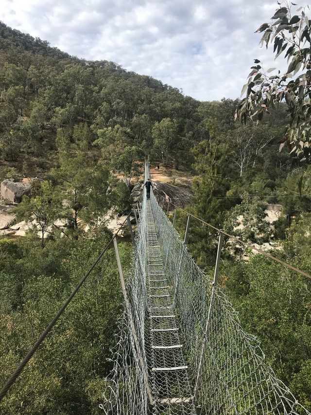
Crossing the bridge

View from the bank on the other side
After crossing the bridge, we took a left turn and set off on the nicest walking section of the whole track. This was much more like the style of track you find on the shorter routes throughout the Mountains. Four-wheel drives don’t stand a chance! After nearly two hours, the track changed again as we approached the Megalong Valley. It was still beautiful but there was much more clearing. The track cuts through grassy rolling hills with spectacular cliff faces all around you.

You know you’re on the right track when ...
You just need to be mindful of these signs. If you haven’t seen any of these in a while, panic! Just kidding (TIP: it’s probably obvious but save one of the walking routes on your phone — ‘Wild Walks’ is good, make it available ‘offline’ and also make screenshots). After crossing the Guyver Bridge (which is near Dry Ridge Estate - nice wine, by the way!), it gets slightly tricky and you need to have your wits about you. At the fork in the road, turn left and follow the road over a few cattle grates towards the old Megalong cemetery. At this point, you actually cross a sealed road. There are a few kilometres left of easy, flat unsealed road and track before you hit the penultimate ascent. Along this stretch, we found a nice spot by the creek to the side of the track to stop and enjoy our packed lunch.

Lunch spot just opposite the site of the old Megalong Village - there is nothing there now besides an informational plaque and a field with horses.
At the bottom of the valley is a steep-ish four-wheel drive-suitable road (about 1 km) that leads to the bottom of Nellie’s Glen, a once-popular day-trip for hikers from Katoomba and the final ascent.

Blissfully ignorant of the final ascent we were about to walk (aka climb)
The track up to the Explorers Tree from Nellie’s Glen was steep and a bit moist. Be careful on the steps, especially if there’s been some recent rain. It’s short in distance but feels much longer for all the energy you exert on the way up. The closer we got to the top, the sunnier it became as we emerged from the rainforest into the cliff-top. There was a bit of false hope at the top, as there were a few hundred metres remaining of flattish track after conquering the stairs. And then, finally, we saw cars. We made it to the car park of the Explorers Tree. We’d reached the end.
Black Range to Jenolan
Pavel (host at the Eco Lodge) told us that this was the nicest part of the whole track. mrshill already wanted to go back and do this part of the track another day but it was Pavel’s seal of approval that finally sold it for me. We returned on Thursday, after hiking the rest on the weekend. I would say that it was a pleasant walk but I rate Cox’s River to Megalong as the nicest part. A lot of the track was set a fair way back from the cliff edges, with rows of gum trees between you and the edge, whereas on most of the other walking tracks around the Mountains you are closer to the edge and therefore able to enjoy the views more. In other parts of the track you are walking adjacent to the main road in to Jenolan Caves which isn’t what we signed up for.

Case in point - this is a road sign. The walking track and the road run alongside each other in sections.
As we got close to the end of the track, there was a fork in the road. Slight right to continue on to Jenolan Caves, or left to Mount George. We’d never heard of Mount George, but mrshill said we’d walked the Jenolan part before. When we last visited Jenolan Caves a few years ago, we stayed for a couple of nights and explored some of the nearby walking tracks. So we chose Mount George.

Let’s try Mount George :-)
It was a steep climb so we stopped for a snack when we reached the ‘summit’. There wasn’t much of a view for all the trees. The view of where we’d come from was more impressive:

Walking down is just as hard as walking up!
So began the walk back to Black Range. On the way to Jenolan (aka Mount George), we scoped out a spot that was at the site of the Jenolan Caves cabins. There was a lovely clearing with distant views of mountains. They also had flushable toilets and running water, which was a treat.

Lunch stop. I love the clouds in this shot.
The remainder of the walk was punctuated by calls of ‘How much longer?’, ‘Are we there yet’, etc, but it wasn’t too bad. So now we can say we walked the whole of the Six Foot Track, albeit in several parts and without camping.
Further reading
Brooke around town has an written an excellent post detailing her experience from Jenolan to Katoomba.
From Katoomba to Jenolan Caves - The Six Foot Track by Jim Smith. My dad already had this book and I read bits of after our initial two-day hike. It’s got great first-hand accounts from folks that initially built the track and travelled along it, along with stories of how it came about. After listening to Pavel’s stories about the history of the track I loved reading this book to find out more.

The Six Foot Track - Katoomba to Jenolan Caves - Second Edition by Matt McLelland. We bought this book after our two-day hike. Obviously it would have been better to have it beforehand but we bought it anyway to have as a keepsake. The best thing about this is that it has detailed routes and notes for both directions of the track, ie. if you read it from the front cover you get the Katoomba to Jenolan Caves route, whereas read from the back cover you get Jenolan Caves to Katoomba.

Posted using Partiko iOS
How wonderful it is to hike: camping, walking, being part of nature, breathing clean air, exercising, meditating, taking pictures ... I congratulate you on the publication and thanks for all the details you wrote. A big hello @mrhill
Thank you. I agree. People don’t spend enough time outside nowadays.
Posted using Partiko iOS
looks like a superb hiking day for sure
that spooky tree would be perfect for Halloween hahah
no pics on the eco lodge from closeby, am interested!
btw, I see that you are a fellow Australian, are you on Discord? come join Team Australia on PAL :)
or lemme tag @choogirl, maybe she can help you to be part of #teamaustralia :)
Hi thanks for the feedback. I have looked at #teamaustralia before but haven’t got around to taking the steps to apply. By the way the photo just above the Eco Lodge subheading is of the lodge itself.
Posted using Partiko iOS
#teamaustralia 🇦🇺🇦🇺🇦🇺
Posted using Partiko iOS
Apologies. I just read your comment again. I didn’t take any close-up pictures of the lodge.
Posted using Partiko iOS
Nice and amazing, your photography friends. Good luck
Congratulations @mrhill! You have completed the following achievement on the Steem blockchain and have been rewarded with new badge(s) :
You can view your badges on your Steem Board and compare to others on the Steem Ranking
If you no longer want to receive notifications, reply to this comment with the word
STOPDo not miss the last post from @steemitboard:
Vote for @Steemitboard as a witness to get one more award and increased upvotes!
That bridge looks fun.
Posted using Partiko Android
ehy dear @mrhill, you really did a good hike !! I love walking in the mountains and being able to sleep in shelters :-)) do you usually do it? your photos are very beautiful, I love that suspension bridge, thrill !!!!! congratulations on your curie rating and all the best for you
Hello Hello!
How nice to take pictures of memories, it must have been great to walk through places like that ...
Greetings from Venezuela!
Thank you. We had a great time!
Posted using Partiko iOS
Hi mrhill,
Visit curiesteem.com or join the Curie Discord community to learn more.
Thank you. I feel very privileged to have received an upvote from the Curie community!
Posted using Partiko iOS
Congratulations @mrhill, your post has been featured in the latest Curie Author Showcase.
On behalf of @curie I thank you for your time and for creating amazing content. Keep up the good work!
Sincerely,
Ivan (@curie curator)
I would probably go with the cheating option too :) It's better to get some food there so that you don't have to carry so much weight. And you were lucky that Pavel was so understanding :) It reminds me that I have to take more cash when I go to the mountains. I keep forgetting that they might not be accepting credit cards :)
Great tour! 45 km is a lot to walk in a couple of days so you did a great job (cheating or not :))
Have a lovely day!