Telerilevamento: l'analisi digitale / Remote sensing: digital analysis

Ciao a tutti! Bentornati nel mio profilo Steemit. Come vi avevo accennato nello scorso post, l'argomento di oggi è incentrato sull'analisi digitale del telerilevamento tramite le piattaforme GIS. Vi invito ad andarvelo a leggere, se non lo avete ancora fatto! Stavolta, però, sarà un post un po' particolare poiché combinato con quello di un altro utente di Steemit (@kaiyoko). In questo post tratterò di tutta la parte teorica riguardante la piattaforma GIS, mentre @kaiyoko vi darà dimostrazioni sulla praticità dello strumento. Ovviamente vi lascerò il suo link in descrizione. Vi auguro buona lettura e a dopo!
Che cosa significa GIS?
Per iniziare, la parola GIS è l'acronimo di geographic information system, ossia di tutte quelle informazioni geografiche che si possono raccogliere digitalmente all'interno di database. Queste informazioni possono essere di vario tipo, ma indubbiamente le principali e più importanti sono le coordinate, base di ogni analisi geografica. Le principali coordinate sono quelle polari, geografiche e UTM e nel prossimo paragrafo vi spiegherò cosa sono.

Hello to everyone! Welcome back to my Steemit profile. As I mentioned in the last post, today's topic is focused on the digital analysis of remote sensing through GIS platforms. I invite you to go and read it, if you have not already done so! This time, however, will be a post a bit 'special because combined with that of another user of Steemit (@kaiyoko). In this post I will cover all the theoretical part concerning the GIS platform, while @kaiyoko will give you demonstrations on the practicality of the instrument. Obviously I will leave your link in the description. I wish you good reading and see you later!
What does GIS mean?
To begin with, the word GIS stands for geographic information system, that is, all the geographic information that can be collected digitally in databases. This information can be of various kinds, but undoubtedly the main and most important are the coordinates, the basis of each geographical analysis. The main coordinates are polar, geographic and UTM and in the next paragraph I will explain what they are.
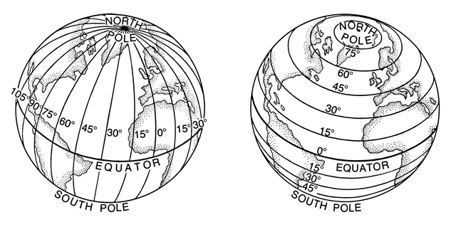
A sinistra: longitudine, a destra: latitudine / To the left:longitude, to the right: latitude
Le coordinate
Le coordinate, come molti di voi conosceranno già, permettono di dare una posizione a un oggetto di nostro interesse, cioè metterlo in un vero e proprio sistema di riferimento. Questa operazione è chiamata georeferenziazione ed è il motore di tutto il sistema GIS. Ma prima di parlare di questo è giusto descrivervi in cosa differiscono le coordinate che ho menzionato:
- COORDINATE POLARI: indicano la distanza planimetrica tra il punto interessato e il polo (non è quello geografico, ma molto vicino) e quale direzione si deve prendere dal polo per arrivare al punto. Queste due coordinate sono chiamate rispettivamente distanza e azimut.
- COORDINATE GEOGRAFICHE: sono semplicemente la latitudine e la longitudine che definiscono la posizione del punto rispetto ai meridiani e ai paralleli.
- COORDINATE UTM: costituiscono un sistema di coordinate cartesiane che permettono l'individuazione di ogni punto sul globo. Gli assi di questi sistemi cartesiani sono i meridiani dei fusi centrali e l'equatore.
The coordinates
The coordinates, as many of you will already know, allow us to give a position to an object of our interest, that is to put it in a real reference system. This operation is called georeferencing and is the engine of the whole GIS system. But before we talk about this, it is right to describe in what the coordinates I mentioned are different:
- POLAR COORDINATES: indicate the planimetric distance between the point involved and the pole (not the geographical one, but very close) and which direction must be taken from the pole to get to the point. These two coordinates are called distance and azimuth, respectively.
- GEOGRAPHIC COORDINATES: they are simply the latitude and longitude that define the position of the point with respect to the meridians and the parallels.
- COORDINATES UTM: they constitute a Cartesian coordinate system that allows the identification of every point on the globe. The axes of these Cartesian systems are the meridians of the central spindles and the equator.
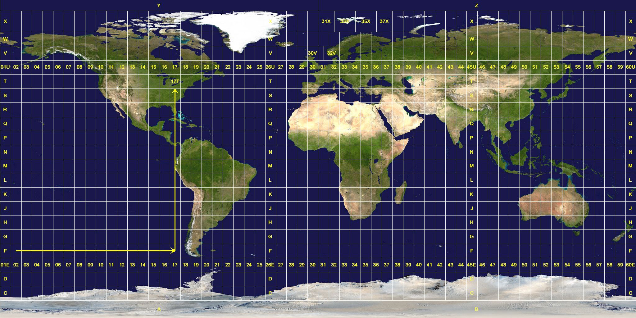
Zone UTM / UTM zone
LINK:https://upload.wikimedia.org/wikipedia/commons/e/ed/Utm-zones.jpg
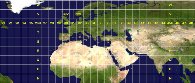
Ingrandimento zona UTM / Magnification UTM zone
La georeferenziazione e i programmi GIS
Con la conoscenza delle coordinate ci è permesso poter georeferenziare un punto, ma ciò cosa ci può permettere di fare in concreto? Sapendo la posizione di più punti, abbiamo la possibilità di effettuare correlazioni. Ad esempio possiamo unire delle mappe preesistenti, unire dei dati di quota raccolti da satellite a una mappa...Ci sono tante cose che si possono fare e queste che ho accennato sono solamente le più basilari. Ma per fare ciò c'è bisogno dell'informatica o meglio di un particolare programma per computer. Per l'uso che ne ho fatto vi posso consigliare due di questi programmi: uno è Arcgis e l'altro è Qgis (ne esistono anche molti altri, ma non li conosco). Arcgis è un software a pagamento, mentre Qgis è un'opensource gratuita. Come programmi devo dire che sono equivalenti e molto buoni, ma poiché ho lavorato molto di più su Arcgis, preferisco parlarvi di quest'ultimo nel prossimo paragrafo.
Georeferencing and GIS programs
With the knowledge of coordinates we are allowed to georeference a point, but what can we do in practice? Knowing the position of more points, we have the possibility to make correlations. For example, we can combine pre-existing maps, combine quota data collected from satellite to a map ... There are many things that can be done and these that I mentioned are only the most basic. But to do this we need information technology, or rather a particular computer program. For my use I can recommend two of these programs: one is Arcgis and the other is Qgis (there are many others, but I do not know them). Arcgis is paid software, while Qgis is a free software source. As programs I have to say that they are equivalent and very good, but since I have worked a lot more on Arcgis, I prefer to talk to you about the latter in the next paragraph.
Logo di Arc map (programma funzione di Arcgis)/ Arc map logo (Arcgis function program)
Che cosa permette di fare Arcgis?
ArcGis è un programma che da modo di avere un'analisi digitale tramite l'utilizzo di database. Non è utilizzato solo nel campo geologico, ma in tantissimi ambiti. Ad esempio se avessi i dati degli italiani con le loro posizioni nel mondo, potrei vedere dove ci sono le maggiori concentrazioni. Nonostante le elevate potenzialità in vari contesti, dal punto di vista geologico, permette di analizzare ed elaborare dati topografici, litologici e morfologici grazie a foto aeree e satellitari o da ricostruzioni di file chiamati shapefile. Gli shapefile sono vettori per sistemi informativi informatici che permettono la ricostruzione di poligoni, linee o punti. Ad esempio posso costruire un file per definire la portata di un fiume o di un lago, oppure di stimare la grandezza di un ghiacciaio in periodi caldi e freddi. Diciamo che da questo punto di vista non ci sono particolari limiti. Anche se ora sto parlando di Arcgis in generale, in realtà la parte funzionale della piattaforma che normalmente si usa è ArcMap. È un'interfaccia che ci permette di fare quanto vi ho descritto poco fa. Qui sotto vi inserirò alcuni esempi di prodotti derivanti dal programma fatti nei miei lavori.
What does Arcgis do?
ArcGis is a program that provides a digital analysis through the use of databases. It is not only used in the geological field, but in many areas. For example, if I had the data of Italians with their positions in the world, I could see where there are the greatest concentrations. Despite the high potential in various contexts, from the geological point of view, it allows to analyze and process topographic, lithological and morphological data thanks to aerial and satellite photos or reconstructions of files called shapefiles. Shapefiles are vectors for computer information systems that allow the reconstruction of polygons, lines or points. For example, I can build a file to define the flow of a river or a lake, or to estimate the size of a glacier in hot and cold periods. Let's say that from this point of view there are no particular limits. Although now I'm talking about Arcgis in general, actually the functional part of the platform that you normally use is ArcMap. It is an interface that allows us to do what I have just described. Below I will introduce you some examples of products deriving from the program by my works.
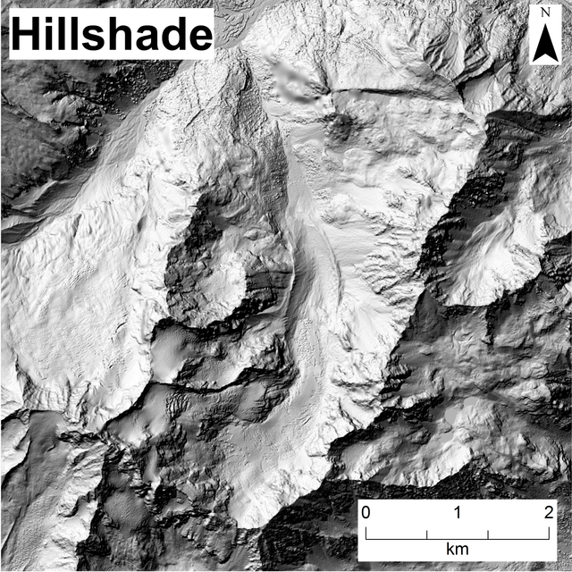
carta delle ombreggiature: permette di vedere bene le forme dei rilievi / Hillshade map: allows you to see well the shapes of the reliefs
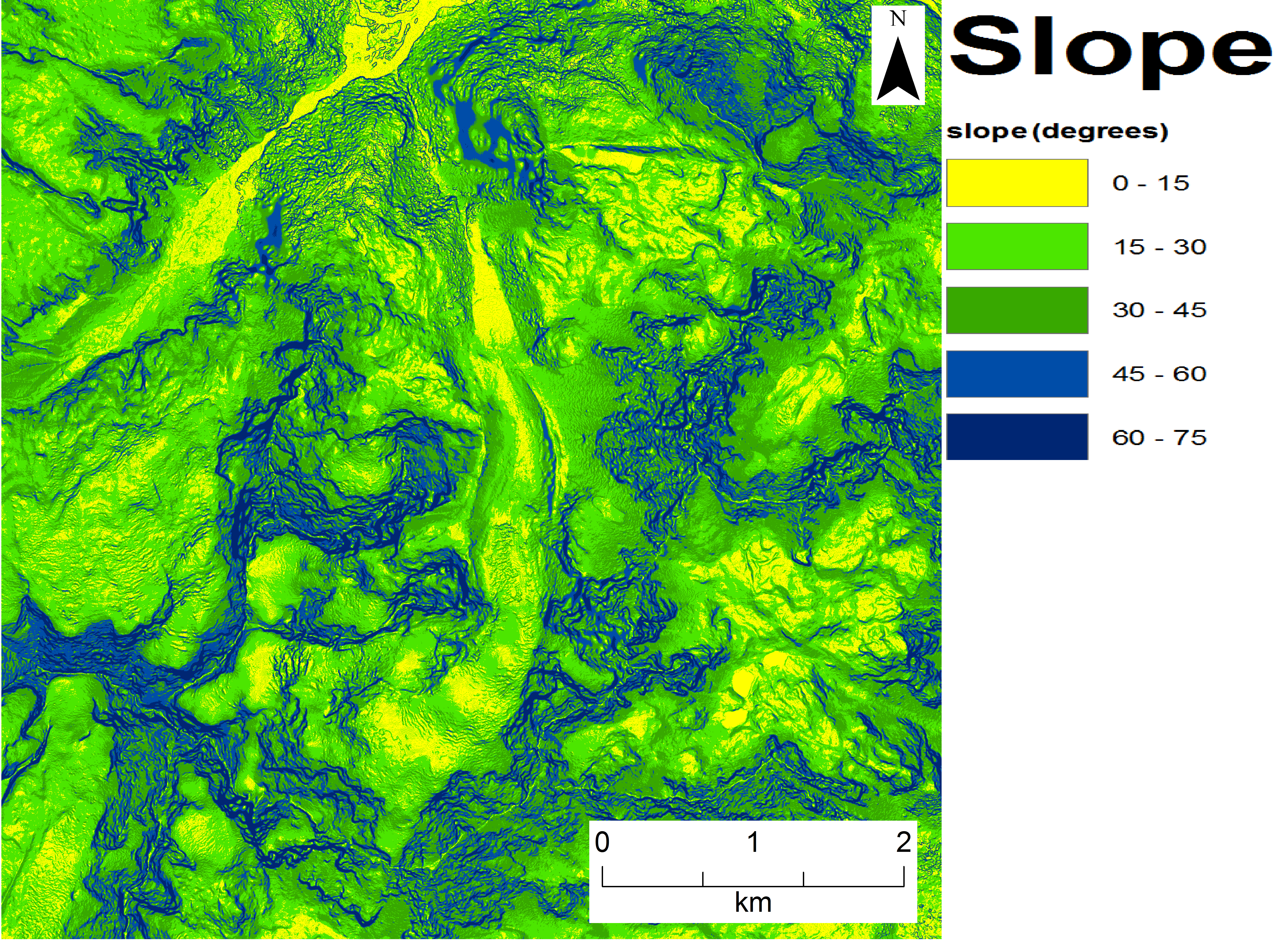
Carta delle pendenze / Slope map

Georeferenziazione tra due mappe / Georeferencing between two maps
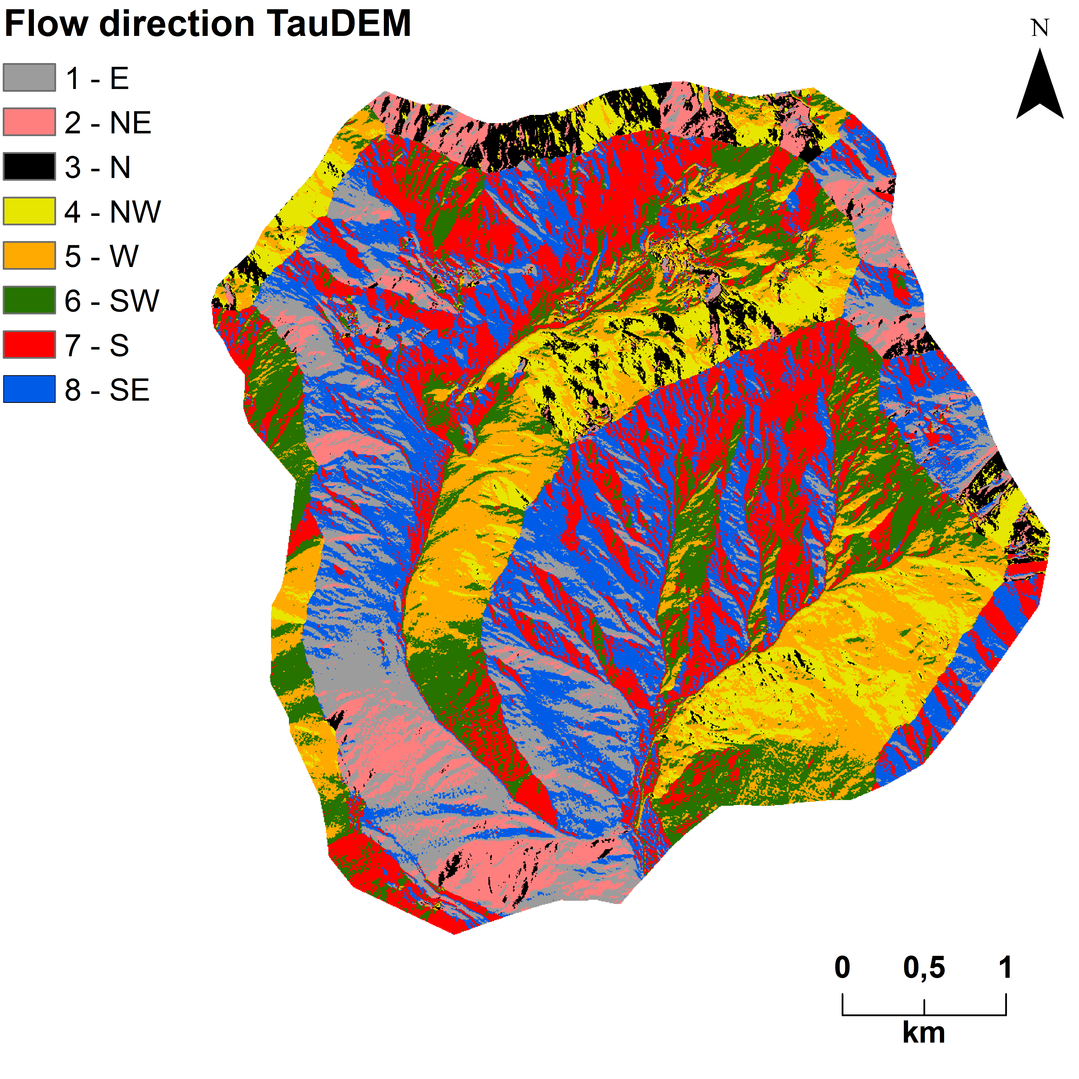
Direzione di flusso dei corsi d'acqua / Flow direction of watercourses
E con questo ho finito la parte teorica per le analisi digitali. Ci sarebbero tante altre cose da dire dal punto di vista teorico, ma sicuramente ciò che trovate in questo post è una buona base per iniziare. In fondo al post vi metterò il link alla pagina di @kaiyoko che vi mostrerà come usare il programma.
Mi auguro che vogliate lasciare un vostro upvote e i vostri commenti. Se avete altre curiosità e richieste, scrivetemi qui sotto e io cercherò di fare dei post a riguardo :) Sono a vostra completa disposizione per chiarimenti. Grazie a tutti e a presto con i miei prossimi articoli! :)
Mi auguro che vogliate lasciare un vostro upvote e i vostri commenti. Se avete altre curiosità e richieste, scrivetemi qui sotto e io cercherò di fare dei post a riguardo :) Sono a vostra completa disposizione per chiarimenti. Grazie a tutti e a presto con i miei prossimi articoli! :)
And with this I finished the theoretical part for digital analysis. There would be many other things to say from the theoretical point of view, but surely what you find in this post is a good basis to start. At the bottom of the post I will put the link to the page of @kaiyoko that will show you how to use the program.
I hope you want to leave your upvote and your comments. If you have other curiosities and requests, write me below and I will try to make posts about it :) I am at your disposal for clarification. Thanks to everyone and see you soon with my next articles! :)
I hope you want to leave your upvote and your comments. If you have other curiosities and requests, write me below and I will try to make posts about it :) I am at your disposal for clarification. Thanks to everyone and see you soon with my next articles! :)
Bibliografia e approfondimenti / Bibliography and insights
Shapefile (link ita): https://it.wikipedia.org/wiki/ShapefileShapefile (link eng):https://en.wikipedia.org/wiki/Shapefile
GIS (link ita): https://it.wikipedia.org/wiki/Geographic_information_system
GIS (link eng): https://en.wikipedia.org/wiki/Geographic_information_system
Coordinate geografiche (link ita): https://it.wikipedia.org/wiki/Coordinate_geografiche
Geographic coordinates (link eng): https://en.wikipedia.org/wiki/Geographic_coordinate_system
UTM (link ita): https://it.wikipedia.org/wiki/Proiezione_universale_trasversa_di_Mercatore
UTM (link eng): https://en.wikipedia.org/wiki/Universal_Transverse_Mercator_coordinate_system
Coordinate polari (link ita): https://it.wikipedia.org/wiki/Sistema_di_coordinate_polari
Polar coordinates (link eng): https://en.wikipedia.org/wiki/Polar_coordinate_system
Link Kaiyoko: ArcMap di ArcGis - Primi passi | First steps [ITA - ENG] https://steemit.com/technology/@kaiyoko/arcmap-di-arcgis-primi-passi-or-first-steps-ita-eng
Link: Telerilevamento: analisi di foto aeree / Remote sensing: analysis of aerial photos https://steemit.com/geology/@mirkon86/telerilevamento-analisi-di-foto-aeree-remote-sensing-analysis-of-aerial-photos


Hai fatto un bel lavoro, per questo hai ricevuto un voto anche da SteemStem

Grazie come sempre :)
continuate così, state andando alla grande!
Yep! :D
Ottimo lavoro Mirkon86. Hai dato una spiegazione molto curata, ora vado da Kaiyoko 😊
Grazie :D. Comunque anche Kaiyoko è bravissima, ma lo vedrai da te :)
Sì infatti, appena visitata 😊
Come sempre un bel post di divulgazione curata. 👍
Grazie! ^^ Sono sempre stato dell'idea di: o fai le cose bene, o non le fai affatto. Felice di aver raggiunto lo scopo :)
Di nuovo un bellissimo post, grazie!
Grazie tante del complimento :)