Telerilevamento: analisi di foto aeree / Remote sensing: analysis of aerial photos

Ciao a tutti! Bentornati nel mio profilo Steemit. Con oggi torniamo ai post scientifici. L'argomento di oggi è il telerilevamento, una tecnica molto usata per l'acquisizione di informazioni geologiche. Nel telerilevamento ci sono due tecniche utilizzate: una è più analogica, se così mi è concesso dire e una digitale. Tralasciando quella digitale (piattaforma gis), la quale sarà argomento del prossimo post, ora vorrei parlarvi di quella analogica, cioè dell'analisi delle foto aeree.
Che cosa é il telerilevamento?
Per iniziare questo argomento, è giusto avere una definizione sul cosa sia il telerilevamento.
Il telerilevamento è una disciplina che si basa sulla misura o l’acquisizione di informazioni su una proprietà di un oggetto o fenomeno, mediante uno strumento di registrazione che non è in contatto fisico o intimo con l’oggetto o il fenomeno che si intende studiare. In poche parole si acquisiscono dati tramite voli d'aereo e piattaforme satellitari.

Hello to everyone! Welcome back to my Steemit profile. Today we return to scientific posts. Today's topic is remote sensing, a technique widely used for acquiring geological information. In remote sensing there are two techniques used: one is more analogical, if this is allowed to say and a digital one. Leaving out the digital one (gis platform), which will be the subject of the next post, now I would like to talk about the analog, that is the analysis of aerial photos.
What is remote sensing?
To start this topic, it is right to have a definition on what remote sensing is. Remote sensing is a discipline that is based on the measurement or acquisition of information about a property of an object or phenomenon, by means of a recording instrument that is not in physical or intimate contact with the object or phenomenon that is to be studied. . In a nutshell, data are acquired via plane flights and satellite platforms.

Come si raccolgono i dati per il telerilevamento (immagine appunti modificata da me) /How to collect data for remote sensing (a note's picture modified by me)
Satelliti e aerei
Dall'immagine (sopra) si può notare che esistono vari modi per recuperare informazioni: da aerei/elicotteri di bassa quota, aerei ad alta quota e da satelliti. Le immagini però vengono raccolte per diverse ragioni e quindi non tutte le quote sono idonee per certe informazioni. Col satellite abbiamo informazioni a grande scala, grazie all'enorme campo visivo (IFOV), ma ovviamente la risoluzione delle piccole cose tende ad essere bassa. Gli aerei, invece, essendo a quota inferiore, hanno modo di coprire aree minori, ma fortunatamente con risoluzione maggiore. Per fare un esempio semplice: dal satellite è difficile vedere le case e poi c'è anche il problema delle nuvole, se uno vuole essere pignolo. Difatti i satelliti vengono usati più per analisi meteorologiche (satelliti geostazionari), ma nel telerilevamento per l'analisi geologica è sicuramente più utile l'aereo. Gli aerei quando prelevano le immagini, viaggiano lungo una linea retta perché devono scattare le foto una consecutiva all'altra per poter fare quindi un'analisi delle foto. Nel prossimo paragrafo vedremo come.
Satellites and planes
From the image (above) it can be seen that there are various ways to retrieve information: from low-altitude aircraft / helicopters, high-altitude aircraft and satellites. However, the images are collected for different reasons and therefore not all the quotas are suitable for certain information. With the satellite we have information on a large scale, thanks to the huge field of vision (IFOV), but obviously the resolution of small things tends to be low. Airplanes, on the other hand, being at lower altitudes, can cover smaller areas, but fortunately with higher resolution. To give a simple example: from the satellite it is difficult to see the houses and then there is also the problem of clouds, if one wants to be picky. In fact satellites are used more for meteorological analyzes (geostationary satellites), but in remote sensing for geological analysis, the plane is definitely more useful. When taking pictures, airplanes travel along a straight line because they have to take pictures one after the other so that they can then analyze the photos.
In the next section we will see how.
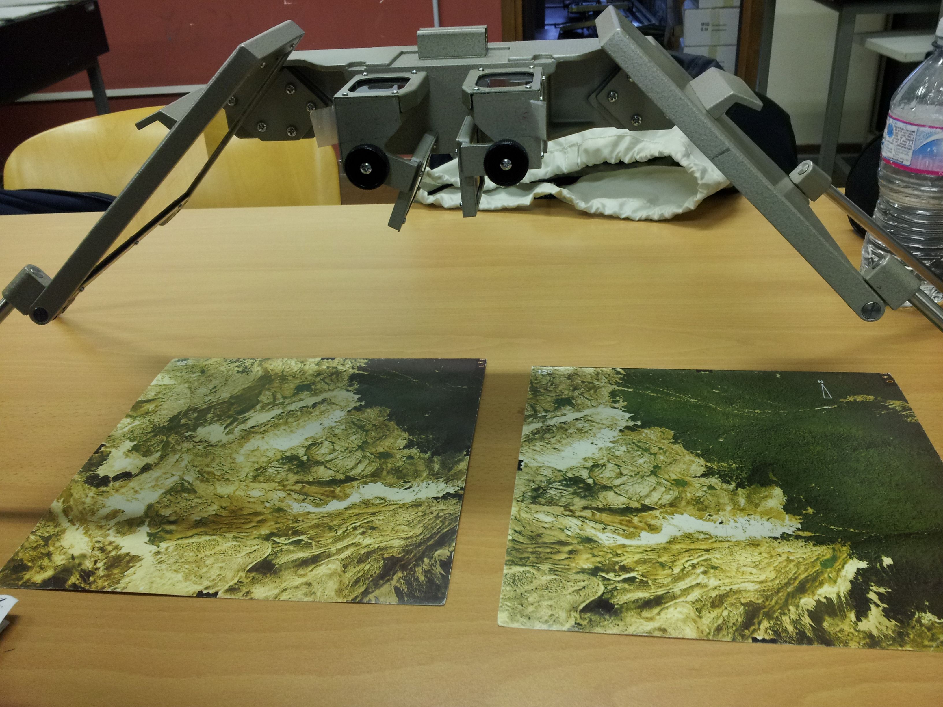 Stereoscopio a specchi / mirror stereoscope
Come si effettua un'analisi di foto aeree?
Le foto aeree si analizzano tramite uno strumento chiamato stereoscopio a specchi. Questo strumento sfrutta gli specchi per tridimensionalizzare un'immagine. Strano, vero? Come è possibile vedere un'immagine su una banale foto, in 3D? Il motivo è il seguente: il trucco sta nel scattare due foto una in fila all'altra, in modo da avere un'immagine a sinistra molto simile a quella di destra, ma con lievi differenze, dovute all'avanzamento dell'aereo. Con queste due foto simili per circa metà, è possibile muoverle sotto lo stereoscopio per far combaciare parte delle due immagini e dare così vita ad un effetto 3D. Devo ammettere che è complesso spiegarlo a parole, ma voglio farvi un esempio su qualcosa che usa lo stesso principio dello stereoscopio. Avete presente la console Nintendo 3ds? Per il 3D sfrutta esattamente questo principio. Vi ho fatto questo esempio perché sicuramente è più facile comprendere da oggetti più comuni, rispetto allo stereoscopio che non conosce quasi nessuno. Ma cosa si può vedere di così importante dalle foto aeree?
How do I perform an aerial photo analysis?
Aerial photos are analyzed using an instrument called mirrored stereoscope. This tool exploits the mirrors to 3Dize an image. Strange, right? How can you see an image on a trivial photo, in 3D? The reason is the following: the trick is to take two pictures one in a row to another, so as to have an image on the left very similar to the right one, but with slight differences, due to the progress of the plane. With these two similar photos for about half, you can move them under the stereoscope to match part of the two images and thus give life to a 3D effect. I must admit that it is difficult to explain it in words, but I want to give you an example of something that uses the same principle as the stereoscope. Do you know the Nintendo 3DS system? For 3D, it takes exactly this principle. I have given you this example because it is certainly easier to understand from more common objects, compared to the stereoscope that almost nobody knows. But what can you see so important from aerial photos?
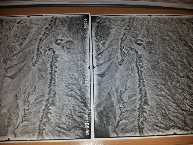
Da che parte andava l'aereo? Destra o sinistra? / Which way did the plane go? Right or left?
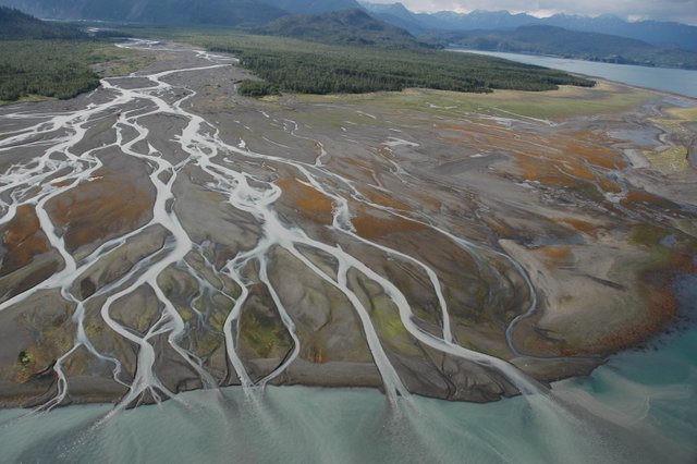
Cosa posso vedere dalle foto aeree?
Prima di rispondere a questa domanda, rispondo a quella dell'immagine. L'aereo va verso destra: è importante sapere da che parte va l'aereo perché così si ha un'idea del movimento (in volo). Giustamente, ora vi spiego anche perché va verso destra. Partiamo che per convenzione, il numero della foto (in bianco) viene messo sulla destra ed è spesso la prima foto. Questo dato già ci da l'idea di come posizionarla. Poi bisogna notare come le strutture geologiche cambiano da una foto all'altra. Se facciamo volare l'aereo verso destra vedremo che l'immagine di destra avrà alcune strutture spostate verso sinistra, ma questo, se ci pensate, è normale. Anche quando siamo in auto, il semaforo davanti a noi, prima o poi ce lo troviamo dietro di noi. Sembrano concetti stupidi, ma credetemi che non sono ovvi subito.
Però ora torniamo alla domanda centrale. Cosa posso vedere dalle foto aeree? Dalle foto aeree posso vedere le forme delle alture (ricordate che vediamo in 3D e quindi vediamo anche le montagne!), le litologie, in funzione dei drenaggi (i fiumi preferiscono litologie rispetto ad altre) e dal colore (Es: se è chiaro è forse sabbia, se scuro forse argilla), i lineamenti (possibili faglie) e le pieghe tettoniche. Da queste foto si possono dire davvero tantissime cose, ma l'importante è spesso descrivere le litologie: sapere questo aiuta molto. Nell'ultimo paragrafo di oggi, infatti, vi farò un elenco per riconoscerne le principali.
What can I see from the aerial photos?
Before answering this question, I respond to that of the image. The plane goes to the right: it is important to know which way the plane goes because this gives you an idea of the movement (in flight). Rightly, now I explain you also because it goes to the right. We start that by convention, the photo number (in white) is placed on the right and is often the first picture. This data already gives us the idea of how to position it. Then you have to notice how the geological structures change from one photo to another. If we fly the plane to the right we will see that the image on the right will have some structures moved to the left, but this, if you think about it, is normal. Even when we are in the car, the traffic lights in front of us, sooner or later we find it behind us. They look stupid concepts, but believe me they are not obvious right away.
But now let's go back to the central question. What can I see from the aerial photos? From the aerial photos I can see the shapes of the heights (remember that we see in 3D and then we also see the mountains!), the lithologies, according to the drains (the rivers prefer lithologies compared to others) and the color (Eg: if it is clear it is perhaps sand, if dark perhaps clay), features (possible faults) and tectonic folds. From these photos you can really say a lot of things, but the important thing is often to describe the lithologies: knowing this helps a lot. In the last paragraph of today, in fact, I will make a list to recognize the main ones.
E ora da che parte va l'aereo? Rispondetemi nei commenti :) / And now which way is the plane going? Answer me in the comments :)
Come si riconoscono le litologie nelle foto aeree?
Le litologie possono essere riconosciute dalle fotografie aeree, adottando la seguente procedura preliminare:
per iniziare si determina l’ambiente climatico (se faccio una foto nel Nevada, so le temperature del Nevada), si determina se l'ambiente è erosivo o meno, si tracciano le stratificazioni visibili e si riconoscono le aree senza strati evidenti, si riconoscono le aree con coperture recenti, si tracciano i lineamenti e si determina se sono faglie, fratture, dicchi ecc.
Fatto questo procedimento preliminare si può poi passare alla rilevazione della litologia. Ora vi elencherò solo i tipi principali.
Conglomerati, brecce e ghiaie
Sono in genere molto permeabili e non consentono lo sviluppo di una rete idrografica superficiale. Il pattern di drenaggio, infatti, è spesso disordinato. La superficie è tipicamente rugosa ed irregolare, con chiazze scure e chiare dovute al gioco di ombre lasciate dai ciottoli. Il colore, denominato tono in questa analisi, è spesso abbastanza scuro, dipendente dal colore dei ciottoli e dal tipo di cemento, ma può anche essere bianco (conglomerati calcarei con cementi carbonatici).
Arenarie
Hanno una porosità e permeabilità variabile e hanno spesso intercalazioni che creano morfologie ad erosione differenziale. Il pattern di drenaggio è generalmente dendritico (a forma di albero), talvolta angolare (trellis). Il tono è generalmente grigio chiaro (scuro se ferruginose) e la vegetazione non è quasi mai fitta. Le sabbie si dispongono spesso in morfologie caratteristiche (dune, barre fluviali, spiagge).
Siltiti (argille e marne)
Sono poco porose e permeabili con pattern di drenaggio dendritico medio-fine o parallelo, quasi mai angolare. Il tono è generalmente grigio scuro e la vegetazione può essere abbastanza fitta. Se ci sono intercalazioni di rocce dure, queste creano gradini morfologici sui pendii in genere dolci e poco acclivi, e condizionano il drenaggio. I calanchi sono morfologie esclusive.
Rocce carbonatiche
Hanno tono molto chiaro e la morfologia in genere accidentata con pochi fiumi in superficie e tutta una serie di caratteristiche forme (doline, valli cieche,…). Se presente, il reticolo idrografico è angolare, angolato o contorto. La fratturazione è generalmente molto ben visibile. La vegetazione è spesso localizzata nelle aree più ricche in suoli (fondo depressioni, fratture).
Rocce intrusive
Sono compatte ed omogenee e non mostrano stratificazioni o scistosità, le lineazioni rappresentando fratture e faglie , messi in evidenza dalla presenza di vegetazione. Il pattern di drenaggio è di tipo dendritico con carattere angolato e/o parallelo. I toni vanno dal chiaro (intrusioni acide) a relativamente scuro (rocce basiche).
How to recognize lithologies in aerial photos?
The lithologies can be recognized by aerial photographs, by adopting the following preliminary procedure:
to start you determine the climatic environment (if I take a picture in Nevada, I know the temperatures of Nevada), it is determined if the environment is erosive or not, the visible stratifications are traced and the areas are recognized without evident layers, we recognize areas with recent coverings, tracing the features and determining if they are faults, fractures, dicchi etc.
Once this preliminary procedure has been completed, the lithology can be analyzed. Now I will list only the main types.
Conglomerates, breccias and gravels
They are generally very permeable and do not allow the development of a surface hydrographic network. The drainage pattern, in fact, is often disordered. The surface is typically rough and irregular, with dark and light spots due to the play of shadows left by the pebbles. The color, called tone in this analysis, is often quite dark, depending on the color of the pebbles and the type of cement, but it can also be white (calcareous conglomerates with carbonate cements).
Sandstones
They have a variable porosity and permeability and often have intercalations that create differential erosion morphologies. The drainage pattern is generally dendritic (tree-shaped), sometimes angular (trellis). The tone is generally light gray (dark if ferruginous) and the vegetation is almost never thick. The sands are often arranged in characteristic morphologies (dunes, riverbanks, beaches).
Silts (clays and marls)
They are not very porous and permeable with a medium-fine or parallel dendritic drainage pattern, almost never angular. The tone is generally dark gray and the vegetation can be quite thick. If there are intercalations of hard rocks, these create morphological steps on slopes that are generally gentle and not very steep, and condition drainage. The badlands are exclusive morphologies.
Carbonate rocks
They have very clear tone and generally uneven morphology with few rivers on the surface and a whole series of characteristic shapes (sinkholes, blind valleys, ...). If present, the hydrographic network is angular, angled or twisted. Fracturing is generally very visible. Vegetation is often localized in the richest areas in soils (bottom depressions, fractures).
Intrusive rocks
They are compact and homogeneous and do not show stratifications or schistosity, the lineations representing fractures and faults, highlighted by the presence of vegetation. The drainage pattern is dendritic with an angled and / or parallel character. The tones range from light (acid intrusions) to relatively dark (basic rocks).
Pattern di drenaggio dendritico / Dendritic drainage pattern LINK:https://upload.wikimedia.org/wikipedia/commons/0/02/Line5066_-_Flickr_-_NOAA_Photo_Library.jpg
Bibliografia e approfondimenti / Bibliography and insights
https://en.wikipedia.org/wiki/Drainage_system_(geomorphology-drainage patterns -link eng)http://freedom.dicea.unifi.it/massimo.rinaldi/Geo&Geom%20CIV%200910/12%20Geomorfologia%20fluviale.pdf (pattern di drenaggio - link ita)
https://it.wikipedia.org/wiki/Telerilevamento (telerilevamento - link ita)
https://en.wikipedia.org/wiki/Remote_sensing (remote sensing - link eng)
https://it.wikipedia.org/wiki/Stereoscopio_a_specchi (stereoscopio a specchi - link ita) https://en.wikipedia.org/wiki/Stereoscope (stereoscope -link eng) https://it.wikipedia.org/wiki/Aerofotogrammetria (aereofotogrammetria - link ita) https://en.wikipedia.org/wiki/Photogrammetry (photogrammetry - link eng)

Secondo me senza un riferimento temporale dei due fotogrammi, l'aereo può andare sia a destra che a sinistra. Una mia curiosità... immagine di sinistra e quella di destra (in ambedue gli esempi) hanno dei contrasti differenti, sono dovuti a qualche filtro particolare? O solo una distorsione cromatica della tua fotocamera?
Ottimo lavoro anche questa volta, un saluto. Nicola
Grazie al tuo ragionamento corretto, mi sono accorto di non aver messo un dettaglio importante nel testo per definire la direzione :) Purtroppo facendo post con la febbre, escono anche gli errori XD. In ogni caso sulla prima foto fatta va la sigla, ma non sempre c'è (come puoi vedere nella foto a colori nel post). A dire il vero tutto questo è un dettaglio relativo, ma è sempre giusto saperlo. Mentre i contrasti differenti sono in funzione di come viene fatta la foto (c'è abbastanza luce, c'è la nuvoletta sopra...). Quindi nessun filtro, ma banale foto fatta magari con luce diversa. In ogni caso non sono foto mie (cioè le foto del post sono mie), ma quelle in bianco e nero hanno 60-70 anni. Ad esempio, come puoi leggere dalle ultime foto in bianco e nero, sono del 1954 ^^ Grazie ancora Nicola della tua opinione che mi ha permesso di fare quella correzione!
Grazie a te.
ah ok, allora sono le stesse foto del rilievo fotogrammetrico dell'Italia che hanno svolto in quel periodo (da buon topografo...). Pensavo fosse un rilievo specifico per attività geologica, ecco perché mi son chiesto se erano stati usati filtri di qualche genere.
ah... complimenti per il podium
un saluto, nicola
Nono nessun rilievo specifico :). A volte vengono usati gli infrarossi per vedere la vegetazione ad esempio, ma raro che venga usato altro ^^
Ancora grazie!
Di sta roba non sapevo nulla, bell'articolo :)
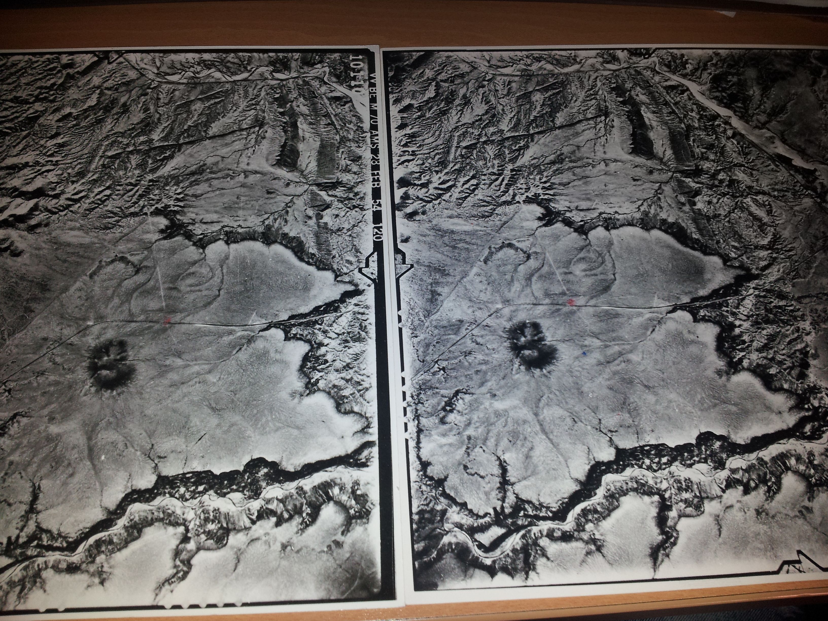
L'aereo va verso destra anche nella seconda foto vero..?
Sì va verso destra ^^ e grazie :)
Un lavorone! Bravo ;)
nonostante la febbre sono stato anche abbastanza lucido alla fine. Grazie :P