FORMATION OF PRODUCTS OF DIQUES AND SILLS, WHICH ARE EACH OF THESE GEOLOGICAL FORMATIONS
Hello welcome to the magical world of geology, in this publication I will talk about the DIQUES and the SILLS, geological formations that give origin to the oil fields, here you can observe a very complete information of this content, also each definition is supported by an image , which is very practical to make this publication much more educational.
GEOLOGY IS THE SCIENCE OF ALL ...
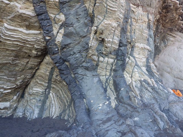
THE DIQUES represent ducts of laminar form and subvertical disposition that cross the lithosphere connecting the magmatic system between different intrusions (sills, plutons, lopolitos, lacolitos, facolitos) and also with the different extrusive manifestations (volcanoes and fissural eruptions). The left image shows several basic dams (basalts) crossing a pelagic sedimentary sequence (Fuerteventura). Its thickness is variable, from centimeters to tens of meters, as well as its route, metric to kilometric. Its composition can be from basic to extremely acidic. Given the texture of fine grain to afanítico that usually present the dikes, the IUGS recommends that in its classification the prefix micro to the name of the plutonic rock, with the exception of the terms still in use of dolerite or diabase for microgabros with intergranular textures. . Dykes can be presented as singular dykes or forming bundles or swarms of dykes. The arrangement of the dyke bundles can be of irregular, subparallel, radial, annular or conical orientation.
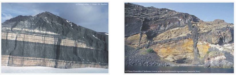
THE SILLS are laminar intrusions of subhorizontal disposition, which tend to be concordant with the structuring of the encajante rock. A difference of the dykes, its extension or lateral propagation can be very large while its growth in the vertical is much lower, giving rise to simple intrusive bodies. They can be considered magma stagnation sites through their path through other magical chambers or fusion areas. The upper left image shows several sills of large dimensions and gabroidea cut intruded in sandstones of the Finger Mountains (Victoria Land, Antarctica). The upper right image shows dykes connected with panels of basaltic composition intruyendo in pyroclastic deposits of the island of Santorini. The bottom of the levees, when reaching levels of neutral buoyancy (the density of the magma is equal to that of the enclosure, or there are lithological limits that prevent its ascent), it deviates laterally following the plane of least resistance. These intrusive units can grow by successive magmatic pulses (in the form of subterranean flows) forming, in the extreme case of stacking in levels, in a floor or, in more superficial and fragile levels, a lopolito or lacolito. At present, knockers are defined as magmatic pulses essential in amalgamation or plutonic growth.
The contact of the dam or sil
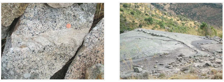
At a detailed scale, if the viscous contrast between the magma of the dam and the embedding rock is high, the contact is net and the enclosure crystals are cut cleanly; if the contrast is low, the contact is net but respects the grain boundaries. At the outcrop scale the contact pattern can be linear or sinuous, indicating an intrusion clearly posterior or very close in time. The left image shows the cooled edge of a granitic porphyry dam in contact with an equigranular monzogranite. The edge, about 2-4 cm, is felsic and with an aphanitic texture. From the edge towards the interior of the conduit both the matrix and the phenocrysts increase in size. In addition, the porphyry presents a magmatic foliation defined by the sub-parallel phenocrysts on contact with granite.
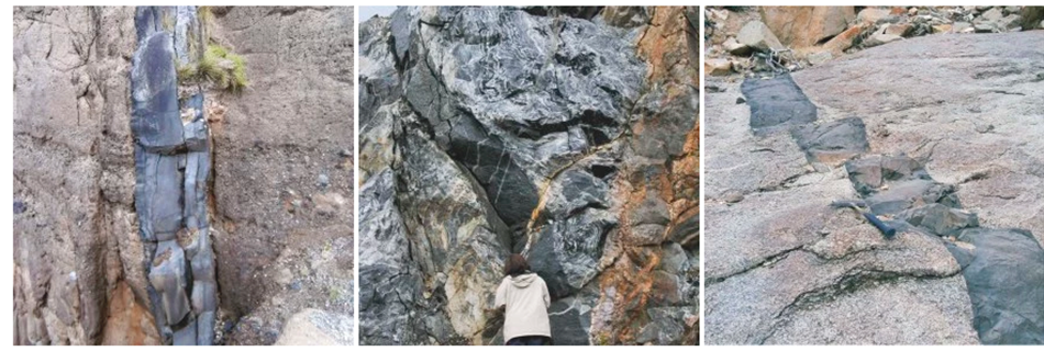
Dams can present zonality from edge to center of the duct due to variations in the size of the crystals (increasing towards the interior of the duct), as is the case of the cooling edges, or by growth in successive pulses. If they present irregular porphyritic textures, the phenocrysts can define a magmatic foliation parallel to the walls of the canal. The levee placement level can be very varied, as can be seen in the upper image gallery of basic levees. In the left image (1) you can see a dike of about 30 cm of power, crossing a pyroclastic deposit (epizonal location). The contact is net and rectilinear. You can see a certain zonality that may be related to different filling pulses (San Miguel Island, Azores Islands, Portugal). In the central image (2) of the gallery you can see a basic dike (power about 1 m) intrusive in deep areas of the crust as it appears crossing a migmatitic complex (fusion area). The dike has net and rectilinear contact but its intrusion must have been late (and not completely posterior) with respect to the migmatization, since there are dikes and veins of granitic melts crossing this dike (quarry of Kaihlankylä, Iceland). The right image (3) shows a basic dike crossing a syenitic intrusion, where the stepping linked to the typical mechanism of intrusion of basic magmas is clearly seen. The contact is net and, although stepped, linear (sienitas of the ring dike of Las Peñitas, Fuerteventura).
Felics dykes.
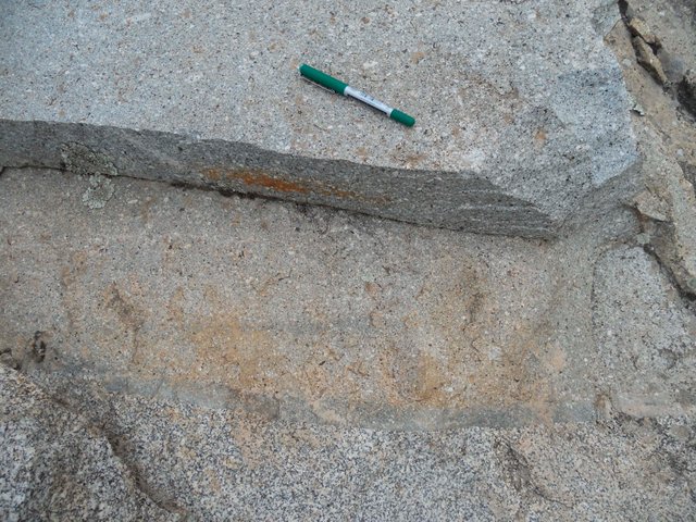
In the left image there are several dykes of aplitic and pegmatitic leucogranite, of about 5 cm of power, with rectilinear contact with the encapsulating granite (from right to left in the upper part of the image and diagonally next to the ballpoint pen). However, on a small scale, these dams are slightly winding (detail photo on the right). This type of contact indicates, on the one hand, the relative closeness in time between the granite and the differentiated aplíticos and pegmatíticos and, on the other hand, the probable more viscous behavior of the encapsulating granite when surpassing 50-60% of already crystallized magma (Alpedrete de the Sierra, Sierra de Guadarrama)._
Felics dykes. In the left image there is an aplitic leucogranite dike (aplita) passing through an amphibolic granite. The dike has about 6 cm of power and presents a net contact with the granite although sinuous in detail (Plutonic massif of La Pedriza, Sierra de Guadarrama). In the right image there is an aplitic leucogranite dike crossing a biotite granite (note that it gives a small projection with respect to the granite). The dike has about 40 cm of power, net contact and rectilinear tracing, of subvertical dip. Its acid composition and its aplitic texture (fine grain and panalotriomorfa) gives it great resistance to erosion, thus highlighting the outcrops.
Swarms of dykes. Very often dams intrude in the form of swarms or bundles of dykes. In the left image a beam of basic dykes is shown crossing a volcanic complex. The dams have very variable powers, of metric order, they are subvertical, of net contact and winding route, with frequent bifurcations. Part of these dams appear as islands of hard rock elongated in the vertical, being thus evident its laminar form. In the most powerful you can see a darker edge, probably a cooling edge.
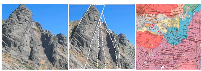
Granitic porphyries. Do granitic porphyry dikes through granites. In this image there are three dams, one very powerful, 50 m (marked as 2 in the interpreted photo) that cuts two dams smaller than 15 and 10 m (marked as 1). They present net and rectilinear contacts, and subvertical dip (to the north). These dams belong to large kilometric swarms of porphyry dams that extend into the Sierra de La Paramera, south of the province of Ávila (see map of image 3, MAGNA series, no. 531).
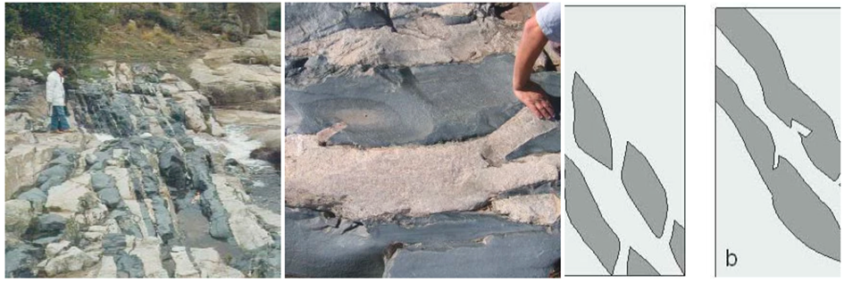
PARALLEL DIES. When at a cartographic scale the levees make swarms parallel to each other, their directions can be interpreted as an indication of the regional stress regime that acted during its location (axis of least compressive effort perpendicular to the dykes). In the gallery of images superior a beam of basic dikes (microgabros) crossing a leucogranite is shown (Charca Verde, massif of the Pedriza, Mountain range of Guadarrama). The dikes, of decimetric power, present net contacts and relatively rectilinear paths in the granitic snapper. The levees bifurcate, narrow and widen, giving a tightly intertwined set. On a more detailed scale (image 2), the contacts of the dam reflect the progression of the step location if the conduit is fed sufficiently: in this case these steps end up widening and converge (see progression outlined in image 3: from a to b) ).
)
)
)
)
)
RADIALES DIQUES
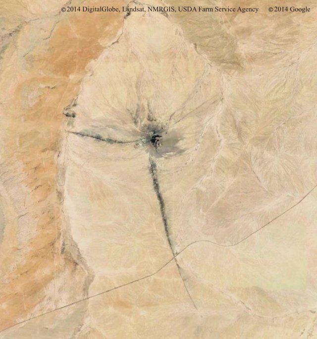
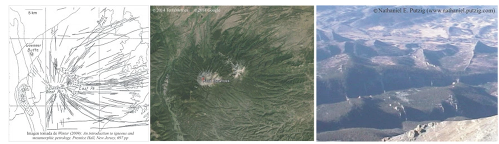
The radial dykes, like the annular and conical dikes, are typical of epizonal and volcanic areas, where the magmatic chambers are a few kilometers from the surface. The radial dikes radiate from a central cylindrical intrusion and define sub-vertical planes, constituting the laminar feeding ducts of possible fissural eruptions. The central intrusive body disturbs the regional stress field giving planes of minimal radial disposition effort through which the magma propagates. In the left image there are at least three radial dams and the chimney of a volcanic pipe currently eroded.
)
_RADIALES DIQUES. The upper images are examples of radial dykes, which show a schematic map with the arrangement of the levees, a satellite image of the same area and, finally, an image in perspective from the central igneous body, where several dams are seen radials of great extension that give topographic highlights (Spanish Peaks, Colorado, USA).
CONICAL DIES. Conical dykes are curved, discordant, concentric introns of the reefs and diverging towards a common intrusive center, describing circular or elliptical dikes in the plant. Like the ring ones, they are part of subsidence complexes, often associated with large volcanic boilers. Under these conditions, the axis of least effort (σ3) is oriented sub-parallel to the earth's surface, while the other two main axes define sub-vertical planes to it, which are the planes through which the magma is injected. The power of the conical dykes is very variable: the basic dams can reach up to ten meters, while the felsic reach powers greater than 60 m.
)
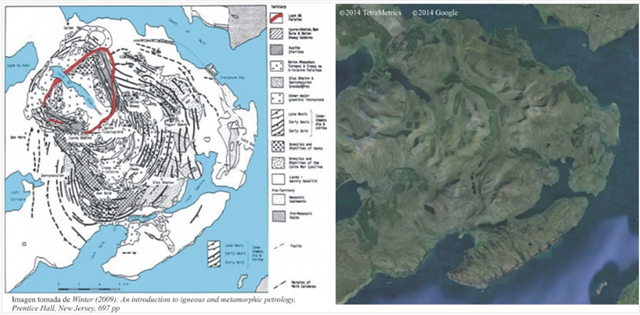
CONICAL DIES. Subvolcanic areas are common where the magmatic chambers approach the earth's surface determine a field of stress with the planes of minimum effort that describe conical shapes above the top of them. The dip inwards is a consequence of the inflation of the chamber that generates a radial compression of the upper block. When it causes the rupture of this block, the magma propagates and fills the hard conical fractures. These subvolcanic intrusions appear in sectors of subsidence linked to large magma evacuations from epigonal magmatic chambers, causing Plinian eruptions and boilers, together with a complex of dikes, annular, conical and central plutons. The satellite image and the upper map show the island of Mull (Scotland, United Kingdom), subvolcanic intrusive center formed by a dense red of annular dikes and plutons.
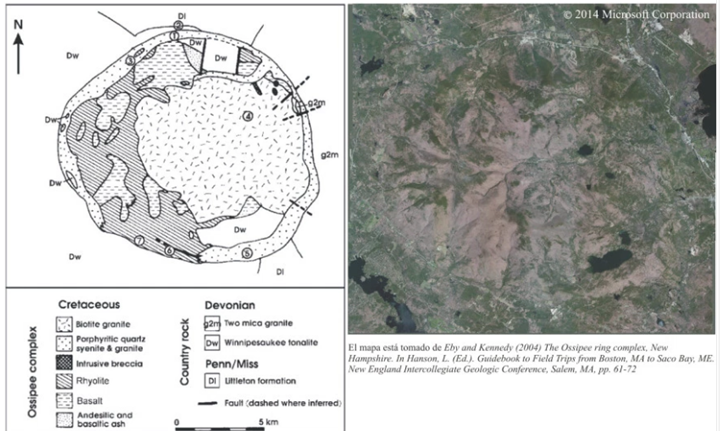
ANNULAR DICKS. They are laminar intrusive bodies that are circular, elliptical, polygonal or arched in plan and have very sharp (subvertical) dips towards the outside of the intrusive center. The powers are variable but can reach up to several hundred meters, and are usually of a felsic nature. The overpressure of the magmatic chamber yields after the formation of radial, conical dykes and the possible extrusion of magma, which causes a collapse in the surface (a circular depression called a boiler) in favor of cylindrical surface fractures. These fractures are filled by magma and form the so-called annular dikes.
)
ANNULAR DICKS. The igneous complex of Ossipee in the volcanic area of New Hampshire is shown on the map and in the upper satellite image, with an annular dam that, due to its felsic nature, gives a topographic and colored highlight, both aspects that can be seen in the image of satellite.
References Bibliography :
https://study.com/academy/lesson/volcanic-vs-plutonic-igneous-rocks-definition-and-differences.html
https://www.volcanodiscovery.com/es/geology/igneous-rocks.html
-https://www.britannica.com/science/igneous-rock/Classification-of-plutonic-rocksR. W. Le Maitre (editor), A. Streckeisen, B. Zanettin, M. J. Le Bas, B. Bonin, P. Bateman, G. Bellieni, A. Dudek, S. -
Efremova, J. Keller, J. Lamere, PA Sabine, R. Schmid, H. Sorensen, and AR Woolley, Igneous Rocks: A Classification and Glossary of Terms, Recommendations of the International Union of Geological Sciences, Subcommission of the Systematics of Igneous Rocks Cambridge University Press, 2002.
Fisher, R. V. & Schmincke H.-U., (1984) Pyroclastic Rocks, Berlin, Springer-Verlag
Tarbuck, E. J. & Lutgens, F. K. 2005. Earth Sciences, 8th edition. Pearson Education S.A., Madrid.
M. J. Unsworth et al. (2005) Crustal rheology of the Himalayas and Southern Tibet inferred from magnetotelluric data. Nature
I have partaken in discussion between dike and dyke, but have never read dique. Are you translating from another language?
You received a 10.0% upvote since you are not yet a member of geopolis and wrote in the category of "geology".
To read more about us and what we do, click here.
https://steemit.com/geopolis/@geopolis/geopolis-the-community-for-global-sciences-update-4
If you do not want us to upvote and comment on your posts concerning earth and earth sciences, please reply stop to this comment and we will no longer bother you with our love ❤️
It's nice to learn something new (I'm a biologist) and now I can impress others non-geologists on the next hike :)