My Faults: A Journey Along the Pacific and North American Plates, Part 3 of 3 (Parkfield to Mexico)
This is Part 3 of 3 in a series of posts. If you have not yet read the previous parts, please find them in my blog. Those posts covered sections of this plate boundary from Alaska to British Columbia to Washington, Oregon, and California. Now we pick up the story again in Central California.
San Andreas Central
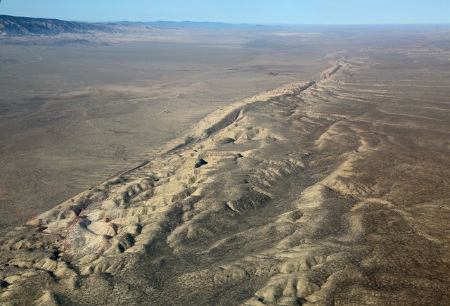
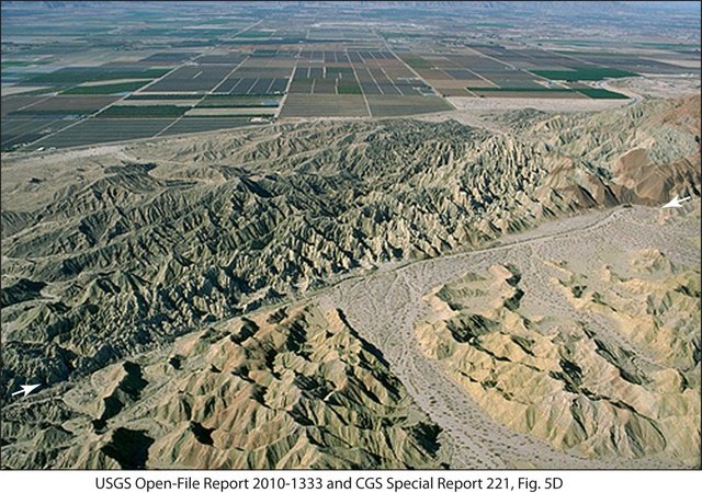
Moving down the map, the fault continues inland, moving southeast through the middle of the state. There’s an odd section of the San Andreas Fault near Parkfield, a sparsely inhabited area in central California where the fault seems to be creeping almost constantly. Here there are lots of smaller earthquakes, in addition to the occasional larger ones like the 2004 Parkfield quake (6.0 magnitude). It’s not well understood how the creeping movement affects larger quakes, but the Parkfield section is wired with sensors and is probably one of the most studied lengths of fault in the world. From the air, if you ever fly in a plane over this section of the fault, you can see it very clearly. As the fault passes through the Carrizo Plain, the land is quite barren, so evidence of this moving rift is quite visible along its surface. It looks like a giant tractor plowed right through the earth and left an ugly track (shown in the top image of this post).
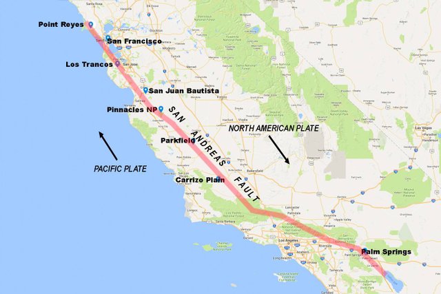
The crack between plates continues inland (parallel to the inward turn of the California coast at Pt. Conception) as it turns more sharply southeast. This means that most of southern California’s population actually lives on the Pacific Plate and not the North American Plate. Los Angeles is left with spider webs of splinter and side faults as the main San Andreas Fault runs closer to the San Gabriel and San Bernadino mountains. The San Andreas comes closest to the west coast’s largest population center where it cuts between these mountains, near Rancho Cucamonga. With no traffic, that’s about a 45 minute drive from Los Angeles itself.
In 1857, the Fort Tejon earthquake (7.9 magnitude) hit hard on the section of the fault line north of LA. In fact, this quake was centered just below Parkfield. From there, the fault ruptured like a zipper for a length of 225 miles (350 kilometers), all the way down to Wrightwood, northeast of Los Angeles. The greatest damage occurred around Fort Tejon. For those who have driven in and out of southern California through the infamous section of the Interstate 5 highway known as “the grapevine”, that’s where Fort Tejon is located.
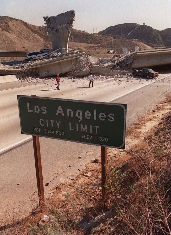
Unfortunately, a 7.9 earthquake today (the size of the 1857 and 1906 ones near Los Angeles and San Francisco, respectively) would cause much more damage now than those did then. The populations were sparse then but have blossomed in the century and more since. Stricter building codes have helped, but a big earthquake will cause plenty of damage.
Los Angeles itself sits on a patchwork of smaller faults, which may be no less dangerous, but are less directly related to the overall movement of the two main plates along the San Andreas. The 1994 Northridge quake (6.7 magnitude) occurred on a previously unknown fault line that was later named the Northridge fault. It resulted in enough damage to make it clear that a larger earthquake on the nearby portion of the San Andreas, or on any of the smaller faults, could result in plenty of destruction in and around LA.
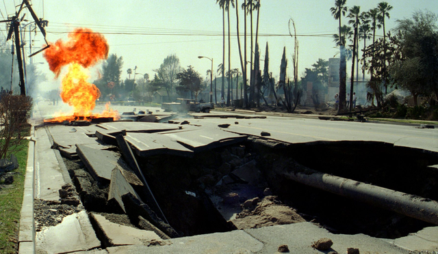
Destruction from the 1994 Northridge earthquake. Source: Los Angeles Times.
Southern Section of the San Andreas Fault
Some scientists are even more troubled by the southern section of the San Andreas Fault, which might be primed for a big event. Southeast of Los Angeles, the fault splits the San Bernadino and San Jacinto Mountains. It passes right by Palm Springs, Palm Desert, Indio, and Coachella. Some historically recent earthquakes there have been the 1948 Desert Hot Springs (6.4 magnitude) and the 1986 North Palm Springs (6.0) quakes. But even though the Coachella Valley has some recent historical experience with earthquakes, there has been a lot of development there in the decades since, enough that the next big earthquake will be more destructive.
The San Andreas fault along the edge of the Coachella Valley. Source: USGS.
At the southern end of the Coachella Valley, the San Andreas fault meets its official end at the Salton Sea. On the map, it doesn’t continue any further. This fault line is not the only thing to have ended its life in the Salton Sea, a very strange place that has little life to it aside from the few species that have adapted to handle the high salinity of this inland sea. But while the great San Andreas is extinguished here, that is not the end of the plate boundary. Here, just a few steps north of Mexico, the story continues.
The Jagged Edge
That's when something curious happens. There is a gap on the map before a zigzagging line becomes the new plate boundary. This gap is called the Brawley Seismic Zone and it sits just below the Salton Sea. Like some other transition spots, it experiences a lot of smaller earthquakes. The regional Imperial fault traces a short line below this, but looking at a larger map, the plate boundary becomes quite jagged as it leaves the United States.
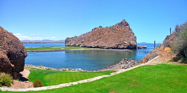
In the northern part of the Gulf of California, just after that plate boundary passes into Mexico, this photo shows the edge of a golf course and the rocky evidence of previous volcanic action along that plate boundary. Creative Commons via Flickr.com by Kurt Eichenbloom.
Crossing into Mexico, this jagged line runs down through the Gulf of California, leaving Mexico’s Baja California peninsula on the Pacific Plate while the rest of Mexico stays on the North American plate. The map of this line looks like a zipper as it splits the gulf. So the Salton Sea basin is the beginning of this line, which comes to be called the East Pacific Rise. Yes, after splitting through the Gulf of California, a section known as the Gulf of California Rift Zone, it continues south through the Pacific Ocean.
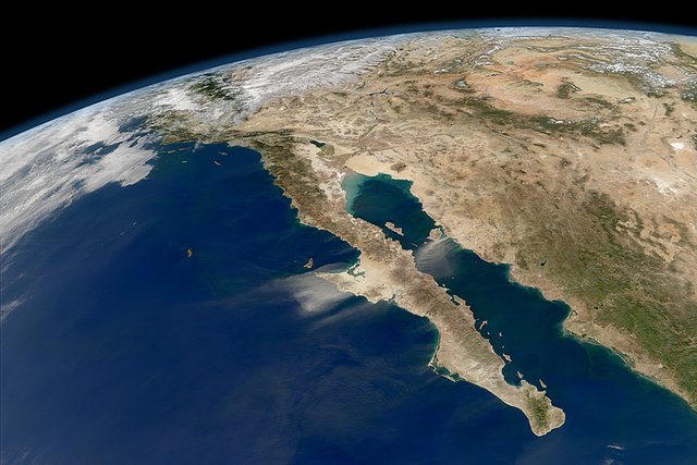
Satellite photo of the Gulf of California. Source: NASA.
On a map, the Gulf of California (formerly known as the Sea of Cortez) resembles another feature we have seen. From Part 2 of this post, you might recall Point Reyes, that small peninsula above San Francisco that is stuck out on the Pacific Plate, moving northwards as the rest of the North American continent drifts south. Not only does the fault line separate them, but there is a thin finger of water there called Tomales Bay that covers part of this fault. On a larger scale, we see the same thing again with Mexico's Baja California province, a peninsula of land that is separated from the mainland by a fault that runs through a thin body of water (in this case, the Gulf of California, once called the Sea of Cortez).
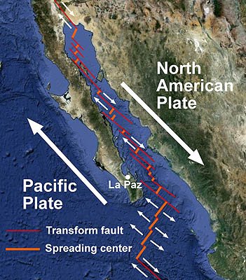
The zig-zag zipper of a fault line that runs through the Gulf of California. Source: Mbari.org.
The End of My Journey and a Brief Look at Where the Lines Go Next
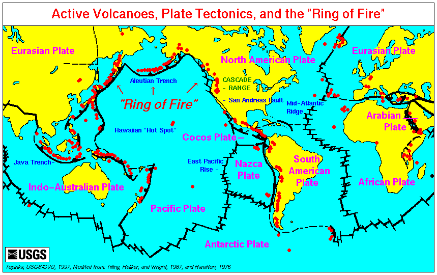
Two smaller plates, the Rivera and Cocos Plates, sit off Mexico’s Pacific shore, while the jagged line forming the edge of the Pacific Plate becomes the East Pacific Rise. It turns south on a maritime heading for Easter Island and points south and then west beneath the Southern Ocean. Eventually, it heads north again towards New Zealand and begins to trace that line of islands from Vanuatu and the Solomons along the Pacific Ring of Fire. But we're way beyond my area there.
Meanwhile, the southern boundary of the North American Plate turns east before we get deeper into Central America. As a result, the North American Plate almost perfectly encapsulates North America, taking the northern Caribbean with it as this southern boundary heads towards the plate’s eastern edge and eventually finds the Mid-Atlantic Ridge.
Though this is way over there on the Mid-Atlantic Ridge, and well beyond the area covered in my posts, here is a video of a woman freediving (with no wetsuit!) at a spot in Iceland where a person can dive in a rift along that ridge that separates North America from Europe. A fault line itself is not merely a surface feature, but is a crack in the large plates underlying the continents, most of it located many miles/kilometers beneath us. Nevertheless, this is still a nice visualization of a rift that is manifested at the earth's surface.
That’s an amazing place, but I feel that I have a lot less understanding of geography outside my home region, which is why I’ve focused on it here. I'll let someone else write about these other places.
Hopefully, you have enjoyed this trip down my portion of the plate boundary. At the very least, perhaps you have learned a few things that you can repeat at your next cocktail party. They might make you sound smart, but as for whether this will improve your social standing, I can’t offer any assurances that you won’t sound like a geography/geology/seismology geek.
Top image of the San Andreas Fault south of Parkfield is used under a Creative Commons license via Flickr.com by Doc Searles. Other images are credited in the text or are public domain or government-produced works that are not copyrighted.
References:
https://en.wikipedia.org/wiki/Aleutian_subduction_zone
https://en.wikipedia.org/wiki/1964_Alaska_earthquake
https://en.wikipedia.org/wiki/Cascadia_subduction_zone
https://en.wikipedia.org/wiki/Cascade_Range
https://www.opb.org/news/series/unprepared/jan-26-1700-how-scientists-know-when-the-last-big-earthquake-happened-here/
https://en.wikipedia.org/wiki/2012_Haida_Gwaii_earthquake
https://en.wikipedia.org/wiki/1700_Cascadia_earthquake
https://en.wikipedia.org/wiki/Mendocino_Triple_Junction
https://en.wikipedia.org/wiki/San_Andreas_Fault
https://en.wikipedia.org/wiki/1989_Loma_Prieta_earthquake
https://en.wikipedia.org/wiki/1994_Northridge_earthquake
https://en.wikipedia.org/wiki/1857_Fort_Tejon_earthquake
https://en.wikipedia.org/wiki/1986_North_Palm_Springs_earthquake
https://en.wikipedia.org/wiki/Brawley_Seismic_Zone
https://en.wikipedia.org/wiki/Salton_Trough
My palms are now sweaty, the video that plays in my mind most of the time, is now on fast forward, zipping through destruction and mayhem. I'm going to fix a drink (yes, alcohol :) and I'm moving forward to something nice, like, I don't know...apples maybe :)
It's scary if you really think about this. The key is to be prepared and then try not to lose sleep over it.
Yes, there's comfort in being prepared for sure.
I have always wanted to buy that strip of land.
100 feet wide and a couple hundred miles long. Then...
It would be all my fault!
I also am finding that the expanding earth model describes earthquakes and movement timing better than plate tectonics (floating plates).
It's everyone's fault! As for expanding earth, maybe but probably not. That theory has been around a long time and no one has really come up with any proof of it. Certainly, there are parts of the earth that expand (such as along the mid-Atlantic ridge) and other parts where expelled magma kind of deflate part of the proverbial balloon and the surface sinks (even while volcanoes deposit new material on top). That also happened along Cascadia during the last big earthquake there when the entire coastline sank, so when one plate subducts under another there can be big changes what we see on top and it seems like a contraction. On a smaller scale, when we drain an aquifer, the elevation drops and there the earth appears to contract rather than expand. I'd be open to other explanations that present actual evidence, but I think we're getting far along now with plate tectonics, though in geologic time it's still a new branch of science.
When the russians drilled their bore hole, after they got 8 miles down, they ran not into lava, but into a slurry of water and granite. So, basically all the previous ideas about the layers of the earth are pretty much thrown out.
Iron, heated to even red hot, is not magnetic. Thus, the idea that the earth has an iron core, and that is why we have a magnetic grid is false.
That gravity is caused by mass has only been shown by one insane rich guy in a barn, and the test never repeated. Electric universe models and aether theory models have different ideas for how gravity is formed. And with massless objects about to come into wide knowledge, then everything we think we knew about gravity will be thrown out.
Then you have hydrocarbons. Deceitfully called "fossil fuels". However, pockets of oil have been drilled into miles below where any earth surface ever might have been. (again, russian deep well drilling) It appears that the earth continually makes hydrocarbons and they bubble up through the earth. And where we find oil is in domed impervious layers, like salt domes.
Even further, you get findings that say the bottom of the Pacific Ocean is some of the youngest geology on the planet.
You add all of these up, and you get a very different view of the earth.
Then you add conspiracy theory and woo-woo...
NASA only has two photos of earth, the rest are confirmed photoshopped images. If the earth was a ball, then we should have thousands of images. One from each manned mission, at minimum.
Then there is the hollow earth theories. SOOOO many stories by so many peoples. That there is other people that live on the inside of the earth.
You add these in, and get in even weirder view of what the earth might be.
So, for me, this looks like an exciting field to be studying. The future will bring us surprises
I have quite often attempted to write a work of fiction based on the destruction caused by fault lines(more of dripping in sci-fi genre though actually) and reading through this post has given me some fresh ideas that I can use :)
Glad it's useful for you. Sounds like an interesting project.
Hey, somehow I missed this one. I saw it as a suggested post when I was reading part 1 of your new story.
I didn't realize that things got so complicated as the faults hit the southern border. For instance, I didn't actually know that Baja Mexico was moving northward. Do they have to check the boundaries every few years to re-mark what is the US and what is Mexico? Ha ha
I don't know that I'll increase my social standing by knowing some of this stuff, but it's still interesting to learn about. Let's hope that it's a long while before the big quakes actually happen.
I am just an amateur interested in geology. It was exciting finding this wonderful, understandable post, and to learn I am living (near Poway) on top of the riverbed of an ancient river! Thank you so much.
Thanks for the comment. I'm just an amateur also. When something interests me, I research it and pretend to look smart, but I have no formal training or work experience in this field at all. Poway: that region seems so dry. I had no idea there was ever much water out there.
Thoroughly educating. Crazy to think the North American plate extends so much. Also a 7.5 and above in current day Los Angeles will be absolutely devastating
These earthquakes can hit any time. We can't predict.the thing which matter is the movement of plates. By the way earthquakes results a big loss depending on the magnitude.
God bless all people who are suffering from earthquakes
Posted using Partiko Android
I'm afraid of these earthquakes because they destroyed a lot of humans life. A lot of people are killed when it shakes the earth. Much thriller.
Hello Friend how are you?
Parkfield has the peculiarity that practically rides on the fault of San Andres, the legendary crack of the Earth located in the state of California, which is what allows us to predict that an earthquake of incalculable consequences will shake San Francisco and Los Angeles from here to year 2036.
Although nobody knows exactly when or what will be their level of destruction.
The San Andreas fault is not difficult to find on a geological map, but in the field of reality, the fault can be elusive
We have definitely met with you about these natural phenomena and their importance to which we should not ignore.
The Lord calms us this era of disasters I am from the continent of Africa there is none of this