Everyday Geography #6 Tracing back common city patterns: Grid plan
Have you ever looked at a map of a nearby city and wondered why it is built like that? Of all possible ways to organize your city functions, why does this city looks totally different from others?
Introduction
Most often the current city patterns are a remnant of the era when the city was expanding. Due to the inertia of these structures, explained in the geological metaphor, they remained the foundation of the current city scape. Since there were many different visions on urban planning in the human history, we can expect a variety of city patterns as well. A very common pattern is the grid. This pattern requires a governance with a significant executive power and sense of order. It appears in many era's and common advantages are:
- Allows for easy division, subdivision and organisation
- Rational and easy orientation
- Flexible expansion
- Maximizes use of land?
Coming at the expense of a few disadvantages:
- Reduced traffic speed due to many intersections
- A lot of land is used for roads
- Low water permeability due to high covered area
- Not everywhere applicable because of different terrains
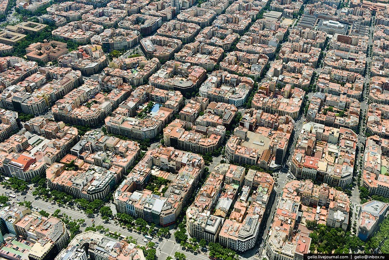
Image source: Barcelona
Ancient Greek and Roman civilization
The Greek and Roman civilizations where one of the first to build grid based cities that can still be seen today. While their civilizations started earlier, they only started building in grids since the 6th century BC. During their need for expansion they often built new cities or demolished conquered cities to found new cities according to the Roman grid ideal. An example of this is the conquest of Numantia (Hispania/Spain). The siege lasted for 8 months and ended with the suicide of most of the inhabitants in 133 BC. After the conquest the town was destroyed and rebuilt to Roman standards.


First image: Numantia before Roman invasion
Second image: Numantia's grid structure under Roman rule
Cities with grids dating back to this era can be found across the extend of the ancient Roman empire, which is situated around the Mediterranean sea.
Asia
China has been a strong, centralized dynasty for a long time and also started building according to a regular city pattern since the first millennium AD. Beijing for example has a grid structure with the Forbidden City in the center.

When Japan became politically centralized during the 7th century, It adopted many of these principles and started implementing grid patterns even until now.
European colonies
In the 15 century, Europe was under the influence of the renaissance, a new form of humanism derived from the Roman concepts and the classical Greek philosophy. With this return of Roman concepts, the concept for urban planning also came back. Many planned communities and cities where built in Europe according to the grid pattern such as New Town (how original...) and Glasgow.

Image source: Google earth - Glasgow city center
The 15th century was also the century of European colonial expansion. Many cities that were founded in overseas territories during that time were constructed on the idea of the grid pattern. This is obvious, just by looking at a map of any city in the United States, Canada or Australia. These countries also continued to develop there cities according to this plan.
Russia
While Europe had constructed for a few centuries according to grids, Russia started adopting the idea. The first planned city in Russia was St. Petersburg. Further expansions of other major cities also followed the pattern.

Present
Not all raster patterns date back from centuries ago. Rarely entirely new cities are built these days, but expansions still use it commonly as they are a rational, efficient and easy to implement. However urban planners are now pointing out the potential danger of increased traffic in this concept as there are many intersections increasing the contacts between pedestrians, cyclists and other traffic.
Conclusion
The grid pattern as foundation for urban planning can be seen as a rational efficient choice under a strong government. While it was thought to be efficient in earlier times, The shift to auto mobility in the past century has changed this idea of efficiency. This was only one of the many common patterns and expect future posts about how other era's shaped the formation of cities. Do you live near a city as such? I'd love to hear about it!
Sources:
ANCIENT ROME City planning and administration
https://www.scribd.com/doc/154898464/1-Linear-Radial-and-Grid-Iron-Layout-Patterns
https://www.quora.com/Is-the-grid-system-in-city-planning-the-most-efficient
https://www.slideshare.net/vjspa/city-forms
https://en.wikipedia.org/wiki/History_of_urban_planning
https://en.wikipedia.org/wiki/Grid_plan
Everyday Geography: previous posts
Everyday Geography #5 Recognize your weather pattern
Everyday Geography #4 Why some dry soils crack
Everyday Geography #3 What makes salt tolerating vegetation special
Everyday Geography #2 Meandering, braided and straight rivers
@OriginalWorks
The @OriginalWorks bot has determined this post by @samve to be original material and upvoted it!
To call @OriginalWorks, simply reply to any post with @originalworks or !originalworks in your message!
That barcelona picture is wonderful. 👍
Thank you, sadly I didn't take that myself
The grid pattern of urban planning brings out the beauty of the city.
There's an incredibly creepy moment in Barbara Hambly's Darwath trilogy (I think in the second book, The Walls of Air), when her historian / swordswoman heroine notices that this one ancient ruined city has no streets, and therefore cannot be a city built by humans.
https://en.wikipedia.org/wiki/Barbara_Hambly#Darwath
http://www.barbarahambly.com
Well thank you for this! sounds like an interesting story