Ceci n'est plus pas Rogatie. (Au moins, j'essayais...)
If you haven't figured out from recent posts, I'm relating to Rogatia, where part of my forthcoming Sevton Saga is set. (More in this writeup from back in May.)
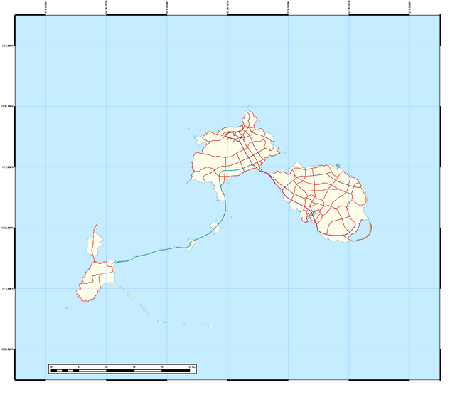
At least Veritas, the G+ gift map whose basic form came alive last month, was a walk in the park compared to you-know-where-next. If only there were a much easier way to retain the shapes of Shropshire, Elmshire, and Yorkshire (and/or their respective terrain) without venturing beyond QGIS and Wilbur--and without losing my mind. (Not helping matters a lot is the absence of GIMP, an open-source Photoshop stand-in, on my currently used USB; it's on the older, smaller-capacity unit I own instead. Heaven knows how much better I would've fared otherwise.) None of the workarounds at my disposal were of much help, as you'll find out below.
- With Wilbur, I invested in a painstaking, time-consuming reconstruction of the Rogatian terrain from old notes, spatial guesswork, and memory--never mind the terraces that resulted. Two runs of the Deterrace tool should've solved my problems, but along with them came a slew of artifacts: The remnants of the "steps" were still visible (and it didn't take long for the Histogram to prove it), a bundle of crisscrossed lines dominated the smoother areas near the shores, and the western part of the DEM (close to Yorkshire) had it a bit worse. Not even the trustworthy Fractal Noise (in Multiply mode) could wipe them all out.
- Not only that--I tried substituting the QGIS-generated Sea Mask with complex Fractalised layouts, en route to "powering" them up as best I could. (To recap, "Min" stands for "minimum height"--or, the replacement value a given point assumes if the counterpart on the preview terrain is lower than the latter's;⊙ meanwhile, "powering" values is achieved with the mathematical function "pow(x, y)".) This was important for Mount Barome's sake, since that highest point is definitely staying within eastern Shropshire. (As much as Trouvaille, the national capital, remains in that province's southwest.) Still, it wasn't uncommon to see the DEM's max height shift away from Shropshire to Elmshire's or Yorkshire's mainland, or a much smaller islet, after several runs of Fractal Multiply. And those are supposed to be lower in altitude--especially the islets. Can you imagine a small, narrow coral bar in Yorkshire's southeast rise above 600 m? Try looking for the likes of that in the South Pacific.
- As for any bathymetry below the Sea Mask? Forget about that, too. Whatever I perused in that regard didn't align well at all with a coastline that was already set in stone. Especially when adding in the Fractal setup above sea level; too many cliffs and dents to worry about. (With Multiplied Fractal Noise, you know where this is going.)
- Back on QGIS, I fetched the contour-level lines via the native Contour plugin--and smoothed them out with the non-native Generalizer--hoping that I could get something out of them. If only it were any simpler: The Interpolation tool was worth a few tries, but nothing satisfactory; beats me how effective the SAGA Gaussian Blur got; and no, we're not wasting any more time on random points-to-rasters. 'Twas nerve-racking enough back in March....
- As a last resort, a combination of v.to.rast.attribute + r.surf.contour (from the GRASS Processing menu) really looked promising. Only one hitch: r.surf.contour works best with small areas and/or low resolution, not regionwide extents like Rogatia's that cause it to bog down for minutes and minutes on end. (Even the official wiki warns about it.) Once it even works, either you get a landscape as decent and smooth as any (with the recommended small doses), or, true to form, you end up with less-than-stellar output containing--you guessed it--more artifacts, and just as worse.
...Alack, what's a poor fledgling geofictioner to do?
Answer: Retire the end result of a design I've hung on to for 10 years (be it on Inkscape, SketchUp, or our recent carto-suite)...
and move full speed ahead with r.surf.fractal + Wilbur Fractal Noise for a brand-new landscape altogether--one province at a time (along with the Atlantic canvas). What recently worked for Novissima and Veritas...will work better for this Drop in the Ocean. (As will any other imaginary realms on my watch for the foreseeable future.) Pains me to say it (as I feared), but once the experience factor sets in...
And when I say "will work better", that's because we'll also rely on Wilbur's Calculate Height Field to work more wonders than the standard Fractal Noise already can. (Now that I figured out which parameter controls were what during Thursday's trials. Except for one thing: What's the Z dimension in the Size pane for? As I've later learned, nothing really. (Saved me a ping to developer Joseph "Waldronate" Slayton at the Cartographers Guild.⊙⊙)
Scrapping my last go-round--and starting over--two hours after press time. Sad to say, this might be for the best. A perfect archipelago crafted for years, gone down the drain in minutes--how much galling can that ever get? Seems I've kind of learned a lesson about depending a bit too much on preset coastlines. That said, I'll come up with something just as unique (for West Indian standards). Again, I'll never really know how well a GIMP conversion could've gone--or how much longer.
Beyond that, Christmas rush applies. It'll be too soon if I don't deliver in the next fortnight--or before the New Year, even.
So that's all we've got for now; I'm starting to get tired from all that typing. Next we meet, an overview of recent happenings in the Dixwell universe (as the Notebook reopens); our first rerun at our new host (re: January's VCL outage); and a smattering of odds and ends beyond the scope of this report. (Relaying the Veritas rundown from r/mapmaking as I find the time.) Coming soon on the cartographic front: Vigesima, St. Isabel, and RFM realm Tovasala--along with its neighbour Cicaldia,⊙⊙⊙ a tribute to none other than Finnegans Wake.⊙⊙⊙⊙ (Wish one of its thousands of esoteric words became my Wikimedia username back in 2005; I elected for "Slgrandson" instead. [First two letters are my grand-relative's initials.])
Stay safe this final Friday the 13th of the decade--and don't get superstitious on the way. (For that matter, did you catch the last full moon of the New Tens as well [at 12:12 a.m. on 12/12]? If so, give me your thoughts.)
Also, expect some resteemed highlights as I prepare my next bulletin. About time!
(Apologies for the dense-looking text, but given the stamina of my recent R&D, this was more or less expected.)
⊙ Determined by the inequality PV < DV = 1 (PV = Preview Value; DV = [Current] DEM Value]). For example, PV = 9 / DV = 70 results in 9; PV = 90 / DV = 60 leaves the value unchanged as 60.
⊙⊙ I planned to join the G+ version of this venerable forum months before I had to move, but never got around to it.
⊙⊙⊙ Pronounced "see-SAL-de-uh"; both that and Tovasala are respective tentative revivals of my earliest full-duty paper-based (and sometimes photocopied) projects, Hartford's Island and Redvale/Valecko. (Good by my pre-digital standards at the time, but now rather shoddy compared to the QGIS et al.-assisted efforts of late. Again, experience is key--and so are reliable resources.)
⊙⊙⊙⊙ Finnegans Wake is in the public domain across Europe, Canada, Australia, and New Zealand (among other territories), but remains copyrighted in the U.S. until 2035.

![]()
(2725)
Posted using Partiko Android