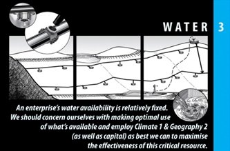
HOLISTIC REGENERATION - The Regrarians® Platform - Part 3 #Water
Water is an incredible dynamic on the land.
There are so many options and opportunities that it can be overwhelming. Yet, if we've performed our first tasks well, many of our questions are already answered before we even get to this stage.
Regardless of your geography and weather patterns, water is an issue. For us here in the Southwest, it’s generally a need to hold and utilize all the water we can. Keeping it on the land, almost always involving multiple uses, is paramount. How can we promote the health and structure of the land to maintain as much moisture as possible?
In wet locations, drainage is the challenge. How can we move water to where it’s most useful without causing harm to the land?
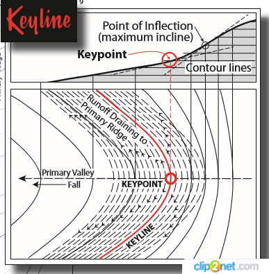
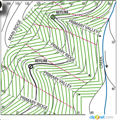
Understanding keyline, or at least contour, to some degree has a massive effect on how one approaches managing water on the land. For those of us used to considering swales, gabions and check dams as basically the extent of our tools, an understanding of keyline is huge. Maybe swales aren't the best tool for your project. Perhaps gabions would cause more trouble than they could ever avoid. It could be that you need to utilize healing techniques such as those employed by Bill Zeedyke, Craig Sponholtz and Neil Bertrando.
But Regrarians aren’t just about figuring out how to move water for permaculture purposes. One of the goals is to develop a regenerative agriculture project that also provides a positive cash flow. Where many permaculturists might settle for not getting water to certain locations (whether for idealistic reasons, resource availability and/or a simple lack of understanding/cognitive tools), a regrarian may go to extra lengths in order to promote the regenerative capacity of the land and the long-term bottom line.
Darren often remarks that this isn’t easy. Folks who make it easy miss the point. It takes hard work. There are calculations to help us understand how much water to expect in a given space and what it’s going to take to safely and efficiently manage it for regenerative purposes.
While 4Access is next, it enters the discussion at this point because it coincides with water so closely. It may be possible that water will be conveyed around a ridge along a road, providing access and moving water to an area where it's potential can be more readily realized with a single multipurpose structure.
Roads can provide nice runoff, but also consolidate water in areas that are not optimum. One of our challenges is to look for ways to pull the water from the roads in order to utilize it to provide more abundance on the land.
And, of course, it is always good to examine the land with feet on the ground after looking at maps. While they're great tools, ideally the design will include both maps and personal observation by walking the property and observing what really happens.
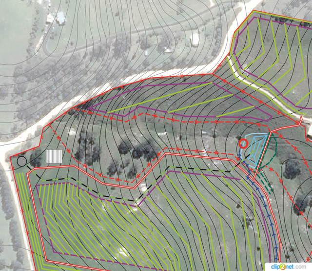
Either one alone will fool your eyes. Often we see a place where we're certain water is moving in a particular direction, only to find out later that it's doing something completely different. And, of course, even the best 3D maps cannot replace getting out and actually seeing how water flows on, affects and is affected by the land.
Water provides for some interesting challenges. Sometimes the majority of the water on the property crosses it in such a manner that makes using it less than ideal for utilizing, such as when it goes through a low point on the property. However, examining the watershed above the property often provides other opportunities as well.
The seasonal flow of creeks or washes cannot be underestimated. To do so could be disastrous. While building dams along them that could handle the water that flows through might not be a huge issue, if a great deal of the watershed is above the property anyway, it might be wiser and more cost effective to put our focus there.
Our tendency is often to focus where the greatest concentration of water flows. We think that this might make the best location for a dam, then pump the water up to where it can be used. While this can often work quite well, there are often other possibilities that are far more sustainable and offer greater regenerative potential.
The higher a pond (or tank) can be located on a property, the better. This puts gravity on your side, plus it helps to hydrate the property downhill simply through seepage. If more water is desirable and storage capacity is available, a ram-pump can be added to streams to help passively move water up from both annual and perennial streams.
Consider the added benefit of having water stored above your home when a fire is raging and the power is out. This is one of the many reasons we're not considering 6Buildings yet.
Rx for the Biosphere (7) Darren Doherty
Another consideration that designers don’t want to miss is the possibility of the watershed flushing far more water from upstream, if it is ever developed. Even if we could build a dam that could handle the current maximum water flow, we would need to build it to handle at least twice as much. This is because the possibility of development above the property could provide more hard surfaces, which would shed more water, and shed it much faster. The possible impact on downslope properties cannot be overstated. And the shock a flood event could put on any dams along a main capillary could be catastrophic, unless dramatically over-designed for current high season flows.
A great example of using water wonderfully, is Joel Salatin's Polyface Farms. They've found that as they've increased the health of the land, not only does it hold more moisture, but the have more springs, including some developing higher up on the land. Darren's wife, Lisa, produced and directed a wonderful film about Joel's farm called Polyfaces (DVD available). Here's the teaser (available in several languages on the site).
The number of tools in our boxes continues to grow, providing insights we couldn’t even begin to ask about before we dove into 1Climate. Here’s to looking forward to learning more about 4Access and how to best use it to help promote the health of the land next.
Feel free to contact me if you desire to discuss your project. If you're interested in hiring Darren, you can find details here.
Steemin' on,
Another Joe

- K-Line Irrigation
- Biologic Design
- Leaky Weirs on Earth Integral
- Savory Institute - The Foundations of Holistic Management
- Ponds - Planning, Design & Construction - USDA
- Design and Construction of Small Earth Dams
- Wildland Hydrology
- Rangeland Hands
- Back from the Brink: How Australia's Landscape Can Be Saved
- MyTopo custom maps
- Regrarians Videos
- Soil Carbon Coalition
- Water For Every Farm: Yeomans Keyline Plan
- The Challenge of Landscape: THE DEVELOPMENT AND PRACTICE OF KEYLINE by P. A. YEOMANS
- Philmac Irrigation Supplies
- Hanflo Irrigation Supplies
- Your Remarkable Reparian
- Glockemann Water Pumps
- GSE BentoLiner
- How to Add USGS Topographic Maps to Google Earth
- Let the Water Do the Work: Induced Meandering, an Evolving Method for Restoring Incised Channels by Bill Zeedyk and Van Clothier
- Watershed Artisans - Craig Sponholtz
- Bill Zeedyk
~ Introduction - 1 Climate - 2 Geography ~

Logo courtesy of @oecp85
Water is such a big deal, especially for regeneration. Your point about going out and really looking at the land is so important.
The folks managing the forested watershed for Santa Fe, New Mexico, have been thinning the trees to reduce the risk of extreme wildfires. They originally thought they needed to remove all the "debris" from the cutting. But in looking at the land, they now know they need to leave chunks of wood all over the place.
The land doesn't have much grass right after it's been thinned, because there's been so much shade from the pines. But each piece of wood acts like a little erosion control dam. As the rain runs downhill, it stops at a piece of wood, deposits sediment, and then has a chance to soak into the ground. The land managers really had a change of view. Some of that wood has a lot more value laying on the ground than being hauled off for firewood, chips, biomass energy, or anything else.
Maps and science and people out on the land - all are important.
Awesome response. I'm guessing you know Craig Sponholtz? Do you know Jeremiah Martin?
I don't think I do. Their names sound familiar, but I don't know them.
They've both done a lot of work in northern NM, Craig especially.
Thanks - I'll keep my eyes open for their stuff.
Thank you for following and upvoting @gardening-trail
Thank you!