New Contest from @Xpilar "home town" 30/11-2017 "get free upvote"
This time I have a new challenge for you in the competition.
Take pictures of the city you live in and tell about the place and the country.
Stories without images are not rewarded.
This picture is from my home town Fredrikstad in Norway. You see the river that goes through our city called "Glomma"
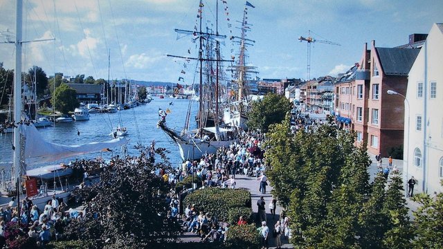
Glomma or Glåma is the longest river in Norway with a length of 604 km long. It's a meander river. The river has its headland in Aursunden north of Røros and flows into the Oslo fjord at Fredrikstad. Glomma is the mainland in the waterway with the same name, which has a total drainage area of 42 441 km² (422 km² in Sweden).
You can read more from my previous post from Fredrikstad here
For now you are going to take pictures and tell about the city and country where you live in
Upload your pictures and story in the comment here and write that you are in contest "home town" To participate, you must also Re-steemed and upvote this contest and write that you have done it.
I want to give good upvote to those who contribute to great stories with pictures
Simple and repeated comments do not get upvote from me. A good comment as content more a few words can be upvote.
This will be a small competition where the best can get up to 50 % upvote.
If you wish, you can also use your story on your own blog as well as the one you post here. Remember to write that you are in competition for @xpilar "home town" So there will not be Spam / plagiarists.
Simple rules as follows: pictures drawings, paintings taken from the web or the media you are not allowed to use, then you must prove that you own it, otherwise no upvot from @pilar
If you use images and information from the web, you need to indicate where it comes from example type "search image credit" or where info is taken from
* Spam plagiarists may be flagged 
In the competition, only one post per participant is allowed

Ilustrated images in this post are credited to Pixabay.com
Re-steemed and upvote this post and write that you have done it in the comments box to be in the competition.
Competition runs in. 4 days before it ends
What are you waiting for, come on, have fun

Entry "Home Town" Competition.
Delhi: Hindustani pronunciation: [d̪ɪlliː] Dilli, officially the National Capital Territory of Delhi or NCT, is a city and a union territory of India. It is bordered by Haryana on three sides and by Uttar Pradesh to the east. The NCT covers an area of 1,484 square kilometres (573 sq mi). According to 2011 census, Delhi's city proper population was over 11 million, the second highest in India after Mumbai, while the whole NCT's population was about 16.8 million. Delhi's urban area is now considered to extend beyond the NCT boundary to include an estimated population of over 26 million people making it the world's second largest urban area. As of 2016 recent estimates of the metro economy of its urban area have ranked Delhi either the top or second most productive metro area of India. Delhi is the second wealthiest city after Mumbai in India, with a total wealth of $450 billion and home to 18 billionaires and 23,000 millionaires.
Delhi has been continuously inhabited since the 6th century BC.Through most of its history, Delhi has served as a capital of various kingdoms and empires. It has been captured, ransacked and rebuilt several times, particularly during the medieval period, and modern Delhi is a cluster of a number of cities spread across the metropolitan region. A union territory, the political administration of the NCT of Delhi today more closely resembles that of a state of India, with its own legislature, high court and an executive council of ministers headed by a Chief Minister. New Delhi is jointly administered by the federal government of India and the local government of Delhi, and is the capital of the NCT of Delhi. Delhi hosted the first and ninth Asian Games in 1951 and 1982 respectively, 1983 NAM Summit, 2010 Men's Hockey World Cup, 2010 Commonwealth Games, 2012 BRICS Summit and was one of the major host cities of the 2011 Cricket World Cup. Delhi is also the centre of the National Capital Region (NCR), which is a unique 'interstate regional planning' area created by the National Capital Region Planning Board Act of 1985.
Delhi's culture has been influenced by its lengthy history and historic association as the capital of India, Although a strong Punjabi Influence can be seen in language, Dress and Cuisine brought by the large number of refugees who came following the partition in 1947 the recent migration from other parts of India has made it a melting pot. This is exemplified by many significant monuments in the city. Delhi is also identified as the location of Indraprastha, the ancient capital of the Pandavas. The Archaeological Survey of India recognises 1200 heritage buildings and 175 monuments as national heritage sites. In the Old City, the Mughals and the Turkic rulers constructed several architecturally significant buildings, such as the Jama Masjid – India's largest mosque built in 1656 and the Red Fort. Three World Heritage Sites – the Red Fort, Qutab Minar and Humayun's Tomb – are located in Delhi. Other monuments include the India Gate, the Jantar Mantar – an 18th-century astronomical observatory – and the Purana Qila – a 16th-century fortress. The Laxminarayan temple, Akshardham temple,Bangla Sahib the Bahá'í Lotus temple and the ISKCON temple are examples of modern architecture. Raj Ghat and associated memorials houses memorials of Mahatma Gandhi and other notable personalities. New Delhi houses several government buildings and official residences reminiscent of British colonial architecture, including the Rashtrapati Bhavan, the Secretariat, Rajpath, the Parliament of India and Vijay Chowk. Safdarjung's Tomb is an example of the Mughal gardens style. Some regal havelis (palatial residences) are in the Old City.
Thanks @xpilar
Rules observed:
Re-Steemed and upvoted
Good pictures and very good information @aabidemi
Hi @aabidemi very good information of your post
(like the pronounce of delhi like my name)

Regard from Aceh, Indonesia
Re-steemed
Ejigbo is a prominent town in Yoruba Land and the headquarters of Ejigbo Local Government Area, one of the oldest local government areas of Osun State in Nigeria. Ejigbo is strategically placed in the middle of the region, as 35 kilometres (22 mi) north-east of Iwo, 30 km (19 mi) from Ogbomoso in the north and 24 km (15 mi) from Ede in the south-east. It is about 40 km (25 mi) north-west of Osogbo, the capital of Osun State, and about 95 km (59 mi) north-east of Ibadan. It is part of the Ede North/Ede South/Egbedore/Ejigbo federal constituency. The population is 138,357 according to the GeoNames geographical database. The average elevation is 426 metres (1,398 ft).
It has an area of 373 square kilometres (144 sq mi) and had a population of 132,641 at the 2006 census. The average annual rainfall is 52.35 inches (1,330 mm), though there are great deviations from this mean value from year to year. Usually, the rainy season lasts from April to October.
Brief history of Ejigbo
Akinjole Ogiyan, The founder of Ejigbo Land
Ejigbo is a major Yoruba town in Osun State of Nigeria. It is about 40 kilometres (25 mi) to Oshogbo, the capital of Osun State.
According to oral history, Ejigbo is an ancient settlement. It was founded by Akinjole Ogiyan (abbreviation of "Ogiriniyan"), right after the old Oyo. Ogiyan has a rich pedigree, as a descendant of Oduduwa and the ruling family of Ile-Ife. Together with his brothers, particularly the Akire, the founder of Ikire-Ile, left Ile life with Oranya (Oranmiyan) – the founder of old Oyo, to establish their own town. The fact that the Ogiyan is from Ile-Ife, is confirmed by "Ejigbo Mekun" the name of a market in Ile-Ife. Akinjole settled many other villages spread around Yorubaland. He was the paramount ruler and prescribed authority over many if not all of them. The following towns and villages, among others, were under him: Ika, Igbon, Olosinmo, Ologede, Inisa, Aato, Ijimoba, Afake, Ilawo, Inisa Edoro, Isundunrin, Olla, Ado Ori-Oke, Ayegunle, Idigba, Ibogunde, Songbe, Olorin, Osuntedo and Iwata.
Around 1835, Ejigbo came under Ibadan, when the Ibadan army moved to protect Osogbo from Ilorin invaders. In fact, detachments from Ejigbo assisted the Ibadan army in the Osogbo, Ijaye, Jalumi, Off, and Kiriji wars between 1840 and 1866. Ajayi Ogboriefon, Balogun and leader of the Ibadan army in the Jalumi war circa 1860 and 1878 was native of Ejigbo from the Akala compound. His mother, Alagbabi, was the daughter of an Ogiyan of Ejigbo. In 1934, when the then government returned to the terms of the 1893 Treaty, which recognized Ibadan's independence and gazettes of the Baale and Divisional Council of Ibadan as an Independent Native Authority, five district obas, including the Ogiyan, were made members of the divisional Council.
The Ogiyan and council were also gazetted as subordinated to Native Authority under Ibadan for Ejigbo District Council. Although changes were made enlarging the membership of the Council between 1937 and 1938, the five districts Obas that included the Ogiyan retained their membership of the said Divisional Native Authority.
Thanks for reading.
@xpilar and everyone.
Good pictures and very good information @willy1
love the history and Very cultural place, voted

Kayangan peak is the top tourist attraction of the hills in the southern coastal area of Bantul regency. Its existence is still rarely known for being a tourist attraction trapper from Goa Pundong Japan. This peak has almost the same viewing angle with Bukit Parangndog located in the southeast of this hill.
Puncak Kayangan is located in the hamlet of Ngreco, Seloharjo village, Pundong district, Bantul district, DI Yogyakarta.

Location Puncak Kayangan Pundong located in the hilly area is still one area with the Pundong Japanese Cave. The route to this place from downtown Yogyakarta to the south passes Jalan Parangtritis. Push into Parangtritis Street until across the Opak River Bridge adjacent to the entrance of Parangtritis Beach entrance fee. Once out of the bridge immediately turn left towards the alternative path Parangtritis-Siluk. Follow the directions board to Goa Pundong where one access road with Sendang Surocolo and Goa Sunan Mas. Entering the area of Goa Pundong Japan follow the asphalt road through the highest cave area that has gasebo view and meet the signpost directions to Puncak Kayangan. Vehicles can be parked by the road and then walk 50 meters to reach the peak area.
Amazing Indonesia voted
Great pictures and information @jroh
in my home town there is the very beautiful place, yeah his name is Kawah Putih. Kawah Putih is a tourist place located at Jalan Raya Soreang - Ciwidey KM 25, Bandung Regency, West Java Province Indonesia.
The location if accessed from the direction of the city of Bandung is 35 KM, with a driving time of about 2.5 hours.
Ciwidey White Crater is now becoming has become the most popular tourist attractions in southern Bandung, and at the same time become Ikon tourist area Ciwidey.
Currently the management of White Crater is done by Perhutani of West Java, and it has been done since 1987.
This place is always busy visited by tourists at home and abroad, especially during the holiday weekend and will be more crowded in the long holiday season such as holidays and new year.
nice @hitz
Luar biasa bandung, Keep it up
White crater is the one of my favorit and thats was awesome place.
Great pictures and information
Re-Steemed and upvoted.
Thank @xpilar to bring this competition.
I'm in the contest : "Home Town"
Lagos popularly known as EKO is a city in the Nigerian state of the same name. The city, with its adjoining conurbation, is the largest in Nigeria, as well as on the African continent. It is one of the fastest growing in the world,and also one of the most populous urban agglomerations. Lagos is a major financial centre in Africa; the megacity has the highest GDP, and also houses one of the largest and busiest ports on the continent.
Lagos initially emerged as a port city which originated on a collection of islands, which are contained in the present day Local Government Areas (LGAs) of Lagos Island, Eti-Osa, Amuwo-Odofin and Apapa; the islands are separated by creeks, fringing the southwest mouth of Lagos Lagoon, while protected from the Atlantic Ocean by barrier islands and long sand spits such as Bar Beach, which stretch up to 100 km (60 mi) east and west of the mouth. Due to rapid urbanization, the city expanded to the west of the lagoon to include areas in the present day Lagos Mainland, Ajeromi-Ifelodun and Surulere. This led to the classification of Lagos into two main areas - the Island, which was the initial city of Lagos, before it expanded into the area known as the Mainland.
Lagos, the capital of Nigeria since its amalgamation in 1914, went on to become the capital of Lagos State after its creation. However, the state capital was later moved to Ikeja in 1976, while the federal capital also moved to Abuja in 1991. Even though Lagos is still widely referred to as a city, the present day Lagos, also known as "Metropolitan Lagos", and officially as "Lagos Metropolitan Area is an urban agglomeration or conurbation.
The exact population of Metropolitan Lagos is disputed. In the 2006 federal census data, the conurbation had a population of about 8 million people. However, the figure was disputed by the Lagos State Government, which later released its own population data, putting the population of Lagos Metropolitan Area at approximately 16 million. As at 2015, unofficial figures put the population of "Greater Metropolitan Lagos", which includes, Lagos and its surrounding metro area, extending as far as into Ogun State, at approximately 21 million
Thanks for reading.
............................................................................
Welcome to Lagos City, Nigeria
The reach of Africa.
Imagecredit
Amazing picture, thanks for the good information @dabbey
nice @dabbey
followed you @dabbey and voted, Are you in the same town with @davidad so? Lagos in Nigeria metropolis town today I see
Yes we are from same city.. thx for your kind comments...
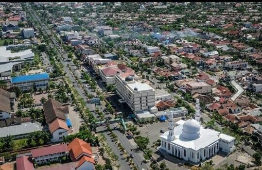
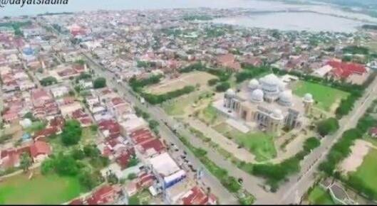
Aceh Utara District
(Aceh: Acèh Barôh, Jawi: اچيه باروح) is a district located in the province of Aceh, Indonesia.
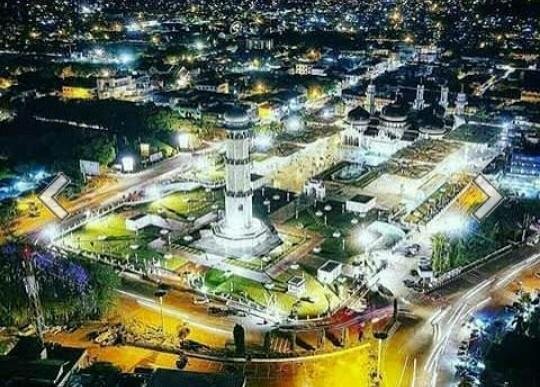
The district's capital was moved from Lhokseumawe to Lhoksukon, following Lhokseumawe as an autonomous city.
This district is classified as the largest industrial area in the province and is also classified as the largest industry outside Java, especially with the opening of liquefied natural gas processing industry PT. Arun LNG in Lhokseumawe in 1974. In this area there are also other big factories: Kraft Aceh Paper Factory, AAF Fertilizer (Aceh Asean Fertilizer) factory and Iskandar Muda Pupuk factory (PIM).
In the agricultural sector, this region has its own reputable reputation as a very important rice producer. then as a whole the District of North Aceh is the most potential Level II region in the province and per capita income above paras Rp. 1.4 million without oil / gas or Rp. 6 million with oil and gas.
Oil and gas fields were discovered in Lhokseumawe, the capital of North Aceh around the 1970s. Then, Acehpun began to be visited by foreign investors who are interested in the great natural resources. Since then, liquefied natural gas or Liquefied Natural Gas (LNG) processed at PT. Arun Natural Gas Liquefaction (NGL) Co., which comes from the installation of ExxonMobil Oil Indonesia Inc. (EMOI) in the Lhokseumawe industrial zone, has transformed the region into a modern petrochemical industry.
Economic activity of North Aceh Regency is dominated by two sectors, namely mining and quarrying sector, and manufacturing industry sector. In the mining sector, gas wells processed by PT. EMOI is certainly one of the advantages of this sector. With a contribution of Rp 8.6 trillion in Gross Regional Domestic Product (PDRB) in 2000, he was ranked first followed by the industry sector of Rp 4.7 trillion.
In the field of religion, the people of Aceh Utara are religiously devout Muslims. In 1994, there were 782 people who went on the pilgrimage.
North Aceh now occupies the former territory of the Islamic Kingdom of Pasai Ocean. Pasai Sultanate according to some opinions mentioned as the first kingdom to adopt the system of Islamic governance in the archipelago. The Pasai Sultanate experienced approximately 300 years of glorious period until the arrival of the European explorer who subjugated the sultanate to almost nothing. Just a little of the history of the greatness of the Sultanate of Pasai that we still encounter today. The most prominent site of Pasai Ocean history is the complex of the tomb of Sultan Malikussaleh and the Tomb of Sultanah Nahrasiyah located in the coastal subdistrict of Samudera now. In the past, often historical artifacts in the form of gold coins found hidden in the ground on the former capital of the ancient Pasai Empire, but now this discovery is rare. When the Dutch invaded Aceh and succeeded in establishing a colonial government in 1904, Aceh Utara was designated an Afdeeling District led by the Resident Assistant. This vast territory is named Afdeeling Noord Kust Van Aceh (North Aceh District). Afdeeling is divided into 3 onderafdeeling (Kewedanaan) headed by a Countroleur (Wedana) namely: Onder Afdeeling Bireuen, Onder Afdeeling Lhokseumawe and Onder Afdeeling Lhoksukon. Besides, the Dutch East Indies government also set some Ulee Balang Regional Power which has self-government to the region and its people. This region is named as Zelf Bestuur In addition to Onder Afdeeling in North Aceh there are also some Ulee Balang Area (Zelf Bestuur) which has the right to govern itself against the area and its people are Ulee Balang Keureutoe, Geureugok, Jeumpa, and Peusangan each Zelf Bestuur is led by Ampon Chik.
After the independence period of Aceh Utara government territory was maintained in the territory once established by the Dutch. Based on Law No. 1 of 1957 and Presidential Decree No. 6 of 1959. The District of North Aceh Level II is divided into 3 (three) Kewedanaan namely: Kewedanaan Bireuen consists of 7 districts, Kewedanan Lhokseumawe consists of 8 Subdistricts, Luckking Lhoksukon consists of 8 districts .
Along with the development and growth of the region, population growth and the spirit of regional autonomy in 1999 on the former Bireun kewedanaan set to Bireuen District and in 2001 Lhokseumawe City following the new municipality out of North Aceh regency.
thank you ferry much
Wah wah wah, Againt from Aceh, Indonesia nice one
Thank you for very good information and a great picture @smeet