The Nazi-Antarctic Survival Myth
German Expeditions to Antarctica
In the first half of the 20th century, Germany had done three Antarctic expeditions, the first (1901-03) the second (1911-13) and the third (1938-39). The third Antarctic expedition happened during Hitler's rule, with the main purpose of the expedition being: to find a suited area for a whaling station and to scout for possible locations for a German naval base.
They used a freighter with two aircraft that could be launched with a catapult system.
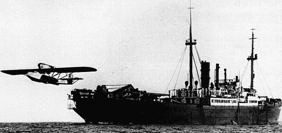
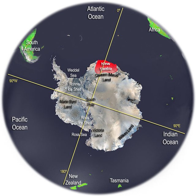
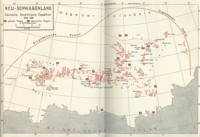
When they arrived in Antarctica, the two Dornier Wal seaplanes set off and undertook a total of 15 flights, altogether flying over hundreds of thousands of square kilometers and taking more than 16,000 aerial photographs of the Antarctic landscape. Steel cones with swastika flags were dropped from the airplanes to mark the German territory, but no formal territorial claim was submitted by the German government. The area was unofficially called "Neu-Schwabenland" or New Swabia. The official narrative says that no whaling station or other lasting bases were built there by Germany.
The Antarctic Survival Myth
The Antarctic survival myth tells us that somehow the Germans managed to make a secret naval base in Antarctica before and/or during the war. One of the alleged quotes hinting towards this is from Großadmiral Karl Dönitz, who was Commander-in-Chief of the German Navy (Kriegsmarine) and who later succeeded Hitler as head of state. In 1943, he allegedly said: “The German submarine fleet is proud of having built for the Führer, in another part of the world, a Shangri-La on land, an impregnable fortress.” Although, the source of this quote has never been found.
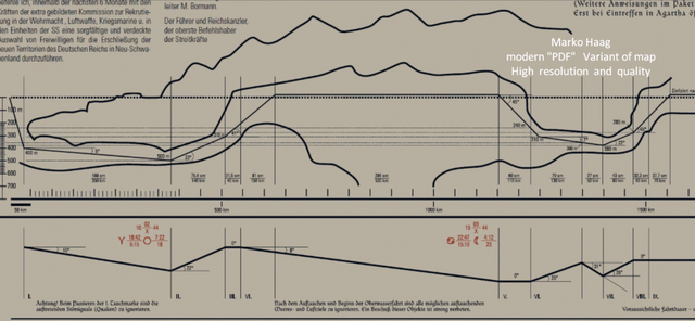
A number of odd documents float on the internet regarding German presence on Antarctica. One of these "official" documents allegedly shows instructions on how to enter a large hollow section under the ice of Antarctica called "Agartha" with an U-boat. It is unknown whether these instructions are official documents or postwar Neo-nazi fabrications.
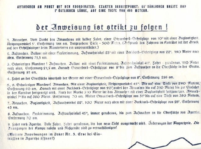
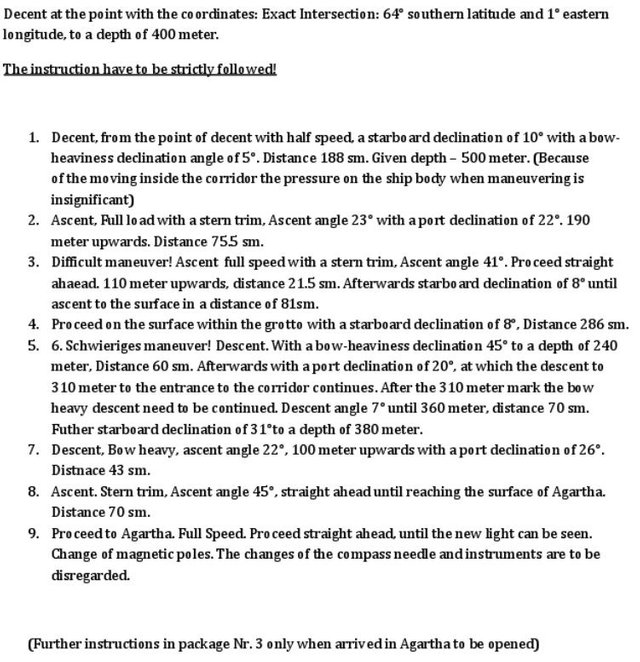
These instructions are taken from alleged German documentation of Antarctica.
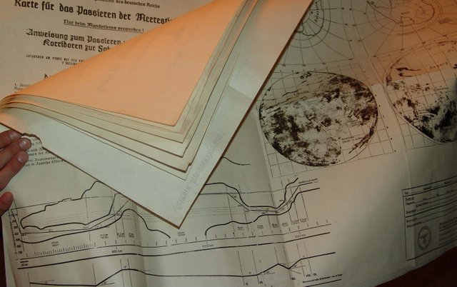
The alleged entrance to the passageway under Antarctica:
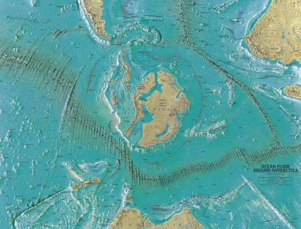
Famous cartographer and artist Heinrich C. Berann made a map for the National Geographic Society in 1966, showing the Antarctic continent without its thick layer of ice. The interesting part is the presence of underwater passages spanning the entire continent, with an entrance at the same area where the Germans held their expedition and later called New Swabia.
In the next part, we will go deeper on the Nazi-Antarctic Survival myth and connect the dots of various post-war incidents on wards. If you are interested to learn more about this myth, be sure to follow!
Information sources:
-New Swabia
-German Antarctic Expeditions
-Documents & Images
Hello @johnthehoan,
Congratulations! Your post has been chosen by the communities of SteemTrail as one of our top picks today.
Also, as a selection for being a top pick today, you have been awarded a TRAIL token for your participation on our innovative platform...STEEM.
Please visit SteemTrail to get instructions on how to claim your TRAIL token today.
If do not wish to be promoted by SteemTrail, please reply with "Stop" to opt out.
Happy TRAIL!

I just upvoted you! But, Why Does One Person Get To Decide for us all? Know the truth.
https://steemit.com/abuse/@iloveupvotes/mass-spamming-mentions-issue-why-does-one-person-get-to-decide