NYC WINDY BELOW NORMAL PUSH ARRIVES
NYC WINDY BELOW NORMAL PUSH ARRIVES
Good morning everyone. Spotty light rain is transiting the area early this morning, signaling the arrival of a reinforcing and stubborn shot of much cooler air. Meanwhile, what looked to be a relatively calm Wednesday is now looking very windy as high pressure remains a little further to our west and a little bit denser than previously expected.
EASTERN SATELLITE

Clouds are here and so is some light rain pushing though. That's associated with a warm front swinging by, followed by a cold front late tonight. We'll have a gusty SSW today, especially at the coast, and temps slightly above normal with mid to upper 60's. We'll have a round of heavier showers overnight, possibly a few rumbles of thunder, and that signals the end of a one-day mild shot for a while.

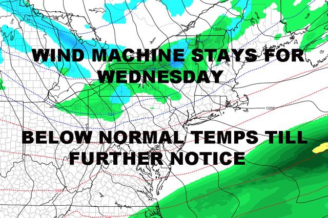
That cold front will be long gone tomorrow, replaced by sunny skies, cool air, and a stiff westerly breeze; highs in the mid to upper 50's. Originally, Wednesday was look calmer and slightly warmer, but the wind stays and we increase the gusts, possibly seeing 30mph+ gusts in areas; highs again in the mid to upper 50's.

Those gusty winds signal a stronger and colder high pressure system settling in over the area, and it'll be relatively cold Wednesday night; where some areas in the outlying NYC metro area could see some frost if the wind subsides. Expect lows in the low 40's in NYC proper, with some 30's on Long Island (if the wind subsides) and possibly even some 20's recorded N&W of NYC.

That relatively cold air sticks around for Thursday, where my concerns were right that some areas might not get out of the 40's. We can take conservative off of the table and now call it for what it is. Look for highs in the upper 40's to low 50's Thursday, then another shot of first overnight in outlying areas; especially with much lighter winds; then we slightly modify into the mid to upper 50's Friday.
Saturday continues to possibly look unsettled with some scattered rain around, especially in the morning. This represents another reinforcing shot of cooler air and Sunday could be in the low 50's and windy again.
FiOS1 News Weather Forecast For New Jersey
FiOS1 News Weather Forecast For Hudson Valley
NATIONAL WEATHER SERVICE SNOW FORECASTS
JOIN JOESTRADAMUS ON YOUTUBE!
LATEST JOESTRADAMUS ON THE LONG RANGE
Posted from my blog with SteemPress : https://www.nycweathernow.com/nyc-windy-below-normal-push-arrives/
Congratulations @joewxman! You have completed the following achievement on the Steem blockchain and have been rewarded with new badge(s) :
Click on the badge to view your Board of Honor.
If you no longer want to receive notifications, reply to this comment with the word
STOPDo not miss the last post from @steemitboard: