EARLY SEASON SNOWFLAKES LESS THAN 24 HOURS AWAY
It's been a sunny but cold day across Long Island.
Temperatures are in the upper 30s to around 40, a good 15 degrees below normal for this time of year. Oh, did I mention it was also quite breezy today? When the wind blew, it felt like it was in the 20s. Overnight lows will drop below freezing across the area, so bundle up tonight and tomorrow morning.
We will keep the cold on Thursday but lose the sun as clouds increase from the south. The storm system is currently organizing across the deep south, grabbing a lot of moisture from the Gulf of Mexico. All of that will run into this cold air mass that is in place, making for an interesting situation and messy PM commute. Winter weather advisories have already been issued north and west of NYC. It is my belief that unless there are any drastic changes, Long Island will avoid them.

Winter Weather Advisories in purple

HRRR at 6pm Thursday evening

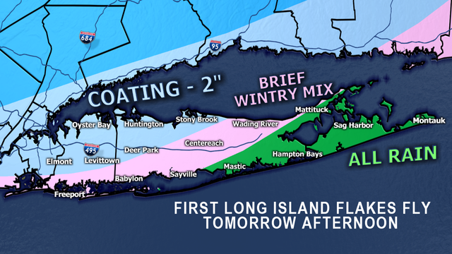
Areas well north and west of NYC could see higher numbers, as the changeover to rain will take place later on there. Some places may not see much of a changeover at all. Parts of northwestern New Jersey and the Hudson Valley may see numbers reach half a foot, especially those in the highest elevations. The models have been hinting at some surprisingly high totals across northern PA and into upstate NY - over a foot of snow! The best guess for this is a deepening upper level low creating heavy precipitation and a large column of frigid air cooling down to the surface. This would mean hours of heavy snow for these areas. It is certainly possible.

By about 8pm, any snow on the island will shortly become a thing of the past as temperatures rise and everyone changes to rain. The rain could actually be heavy at times overnight, perhaps leading to some localized flooding. Rain tapers off on Friday morning, with partial clearing during the afternoon. It will be breezy and chilly with temperatures still below average. And despite dry weather for the weekend and early next week, they are going to stay that way.
Do we get fall weather back anytime soon or just delve right into winter? Stay tuned for my long-range forecast coming up later this week.
Have a great evening!

Posted from my blog with SteemPress : https://www.weatherlongisland.com/early-season-snowflakes-less-than-24-hours-away/