Venezuela a beautiful country.
If you have not had the opportunity to come to this beautiful country and see all the beauty of this land, I leave some images for you to see and so you are encouraged to visit our beloved Venezuela.
Mochima National Park

The Mochima National Park was decreed as a national park in 1973. It extends along the maritime coast of Venezuela between Puerto la Cruz and Cumaná.

Choroní.

Choroní is a town in the state of Aragua, Venezuela, located in the foothills of the Cordillera de la Costa, which adds the peculiar natural elements of the coastal strip of Henri Pittier National Park. Its main economic activities are linked to fishing, cocoa agriculture and tourism. The word Choroni comes from the name of the natives who inhabited the valley occupied by the parish of the same name.
Colombian Port.

Village of Choroni.

choroni beach.

Bahia de Cata.

The Bahia de Cata is a beach in the state Aragua, of great extension, fine sand, and crystalline waters. In addition to the Bay of Tasting, the coast of Aragua has beaches such as Catica, La Ensenada de Juan Andrés and Cuyagua, Ensenadas de Chuao , Coffee, Puerto Maya and La Ciénaga, which can only be accessed by sea or by excursions, through the Henri Pittier National Park.
Medina beach.

Playa Medina is one of the most beautiful beaches in Venezuela. It is the typical tropical beach with coconut trees, white sands and waters of an intense blue.
Margarita Island.

The island of Margarita called the "Pearl of the Caribbean" is located southeast of the Caribbean Sea, northeast Venezuela, north of the Araya peninsula of Sucre state. Together with the islands of Coche and Cubagua, it is the only island state in Venezuela, called Nueva Esparta. The island played an important role in the history of independence of Venezuela.
Parguito Beach.

Los Roque.

Los Roques Archipelago National Park was founded in 1972, under the presidency of Rafael Caldera. Formed by some 50 islands and some 292 cays and banks of great diversity and scenic beauty. It is located in the Caribbean Sea, almost in a straight line north of the city of Caracas.


The Gran Sabana.

The Gran Sabana is a region located southeast of Venezuela that extends to the border with Brazil and Guyana. The Gran Sabana is part of one of the most extensive National Parks in Venezuela, the Canaima National Park, which offers unique prehistoric landscapes with rivers, waterfalls, valleys, jungles, tepuis, and much more.
Angel jump.

Angel Falls is located in Canaima National Park in Bolivar State. It is the highest jump in the world, fifteen times higher than Niagara Falls. The mountain from which it is born and rushes is known as "The Auyantepuy" and it is a gigantic flat plateau (Tepuy). Gambo fame in 1937, after the American aviator and adventurer James C. Angel (from whom it receives the name) landed on the Auyantepuy in search of supposed gold on the top of the mountain.
Roraima.

Roraima is the highest point of the chain of plateau tepuyes of the mountain range of Pacaraima, in South America. The peaks of the plateaus of the park are considered some of the oldest geological formations on Earth, dating back to about two billion years, in the Precambrian.


Cave of Kavac.

In the community of Kavac, at the foot of the gigantic Auyantepuy in the State of Bolívar, the star excursion is to the Kavac Cave. You arrive by plane from Ciudad Bolívar, Puerto Ordaz or Canaima to a Pemón camp where you sleep in beautiful churuatas guarded by the stone wall.
National Park Médanos de Coro.

The Médanos de Coro National Park is located in the Falcón state in northwestern Venezuela. Its most important area is circumscribed around the isthmus, on the road to the Paraguaná Peninsula on the north side of the city of Santa Ana de Coro. Los Médanos de Coro was declared a national park on February 6, 1974. This national park preserves the largest desert on the Caribbean coast and is the closest protected area to the Gulf of Venezuela.

El Ávila National Park.

El Ávila National Park is located in the Cadena del Litoral within the Cordillera de la Costa. It extends from Caracas and all the north of the Miranda state and south of the Vargas state. In 1958 it was declared a national park. This mountainous formation is considered emblem and lung of the city and within it different activities can be carried out as it is one of the main attractions of the capital.

Naiguatá Peak.

The Naiguatá Peak is the highest in the Cordillera de la Costa. It is located on the border between the Miranda and Vargas states, in the central-western sector of El Ávila National Park north of the city of Caracas. Its name comes from the town of Naiguatá located on the coast of the Vargas state. It has an altitude of 2765 m and is the highest point of these two states and the second highest in the Caribbean after Pico Duarte in the Dominican Republic.
The Bolivar Peak.

The Bolívar peak is part of a set of peaks located in the Sierra Nevada within the homonymous national park in the Cordillera de Mérida. Along with the peaks brothers: Humboldt and Bonpland form the main peaks of the Venezuelan Andes. It receives its name in honor of the Venezuelan Liberator Simón Bolívar, and in April of 1951 was unveiled a bronze bust of the Liberator at the summit of peak, work of the painter and sculptor Marcos León Mariño.

Virgin of Peace.

The Virgen de la Paz Monument is a colossal commemorative sculpture of the Virgin Mary, made entirely in the city of Trujillo. At 46.72 meters high, 16 meters wide, 18 meters deep at the base and some 1200 tons, it is the tallest living sculpture in America, being centimeters taller than the Statue of Liberty in New York and the statue of the Christ the Redeemer of Rio de Janeiro in Brazil. It is the statue dedicated to the highest Virgin Mary in the world.

The Colonia Tovar.

Founded in 1843 by a group of German and Dutch immigrants seeking refuge for the First World War. It is characterized by maintaining the cultural imprint of its origin. Nowadays Colonia Tovar depends basically on agriculture and Tourism.

Galipan.

Galipán is a small town located on the northern slope of Cerro el Avila, in the state of Vargas, Venezuela. It is famous for its flower gardens and succulent restaurants.

National Park Sierra Nevada.

The Sierra Nevada National Park is an important National Park of Venezuela located between the states of Merida and Barinas in the west of the country. Created with the objective of protecting the Sierra Nevada de Mérida within the Andean Cordillera. With its creation, it became the second nationally decreed park, after the Henri Pittier National Park, which would begin the history of Venezuela's national parks 15 years earlier.
Laguna de Mucubají.

The Mucubají lagoon is located in the Sierra Nevada Park, in the state of Mérida. It is one of the largest in the region and it is believed that the name of the lagoon is due to how it was named by the indigenous inhabitants of the region. Mucubají means in that dialect: Large water site.
The Black Lagoon.

The Black Lagoon is located in the Sierra Nevada National Park, in the state of Mérida, several kilometers from the Mucubají Lagoon. The Black Lagoon is one of the main tourist attractions of the state of Merida, and is striking for its dark color.
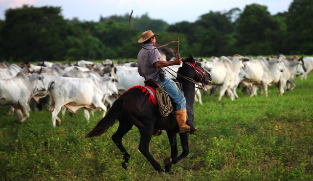
And we could not forget our Venezuelan Llanos.
Sunset llanero.


General Rafael Urdaneta Bridge.

The General Rafael Urdaneta Bridge crosses the narrowest part of Lake Maracaibo, in the Zulia State, and connects the city of Maracaibo with the rest of the country. It was named in honor of General Rafael Urdaneta, a Zulian hero of Venezuelan independence. It is one of the largest in the world of its kind, and number 52 in the world.
Maracaibo lake.

Cave of the Guácharo.
The Cave of the Guacharo, was visited for the first time in 1799 by the German naturalist Alejandro de Humboldt. It is located 4km from the nearest town that is Caripe del Guácharo, north of the Monagas State, right in the Cerro Negro sector of the Caripe massif. It is carved in sedimentary rocks that were formed 130 million years ago in the secondary era in an ancient sea.

Union of the Orinoco and the Caroni.

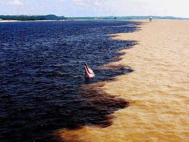
The Caroní River with its dark waters product of the content of organic acids, and the Orinoco River with its great amount of sediments of rather earthy color. This is due to the way the basin is managed, which mainly generates sediments due to erosion that results from the loss of vegetation cover.

Henri Pittier National Park.

The Henri Pittier National Park is the oldest national park in Venezuela, originally created in 1937 under the name of Rancho Grande by decree of President Eleazar López Contreras. It is between the coasts of Aragua and the mountainous areas of Carabobo. It can be seen from the road to Ocumare or Choroní, but it is much more interesting to walk it. Two of the best known trails are Turmero-Chuao and San Joaquín-Cumboto. In both cases the mountain is crossed and ends at the coast.
And now that you have completed this tour of this magical land called Venezuela, your country, my country, our country, what do you think?

No hay nada como Venezuela. Hermoso . Pasate por mi blog
Que hermoso mi país, como han tratado tan mal nuestros recursos naturales!!