HIKING SEDONA - Trip Report from Hi-rise and V-V Ranch - Petroglyphs in N. Arizona
HIKING IN SEDONA - OAK CREEK CANYON PETROGLYPHS
Visiting friends and family in Arizona this month, and had a chance to get out to see Dr. Bob in Oak Creek Canyon, near Sedona last week.
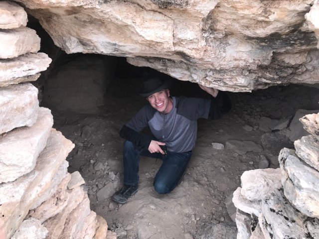
His son Vlad showed us around a hi-rise peak, forced up like a skyscraper in the middle of the flat river valley. From up there it's possible to see 360 degrees all around and it only took 25 minutes to climb it. No Trail(!) He showed us old cave dwellings built into the side of the mountain by the ancient local Indians, who could easily monitor the entire area from up there.
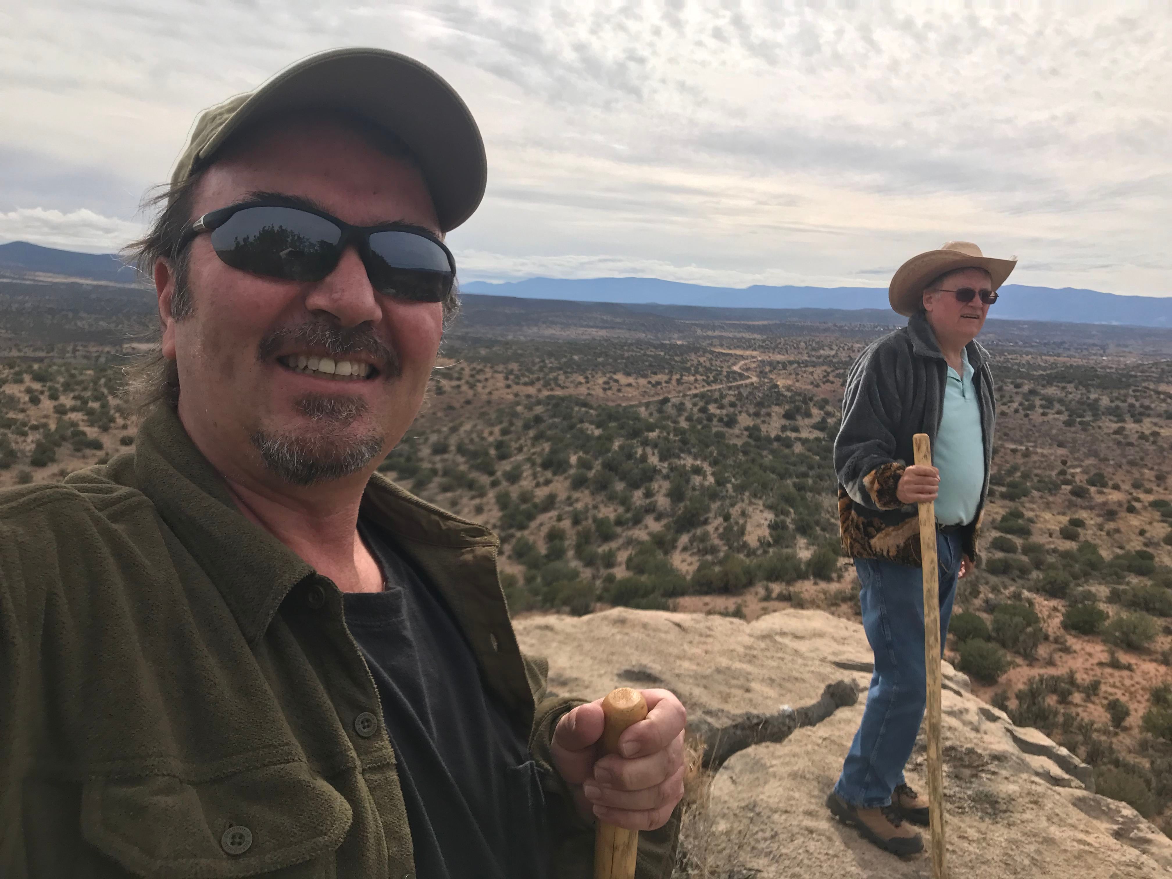
It's close to 300 meters tall I would estimate, around 1000 ft. Gives a great view of the surrounding Beaver Creek and hyway 17 going north to Flagstaff.
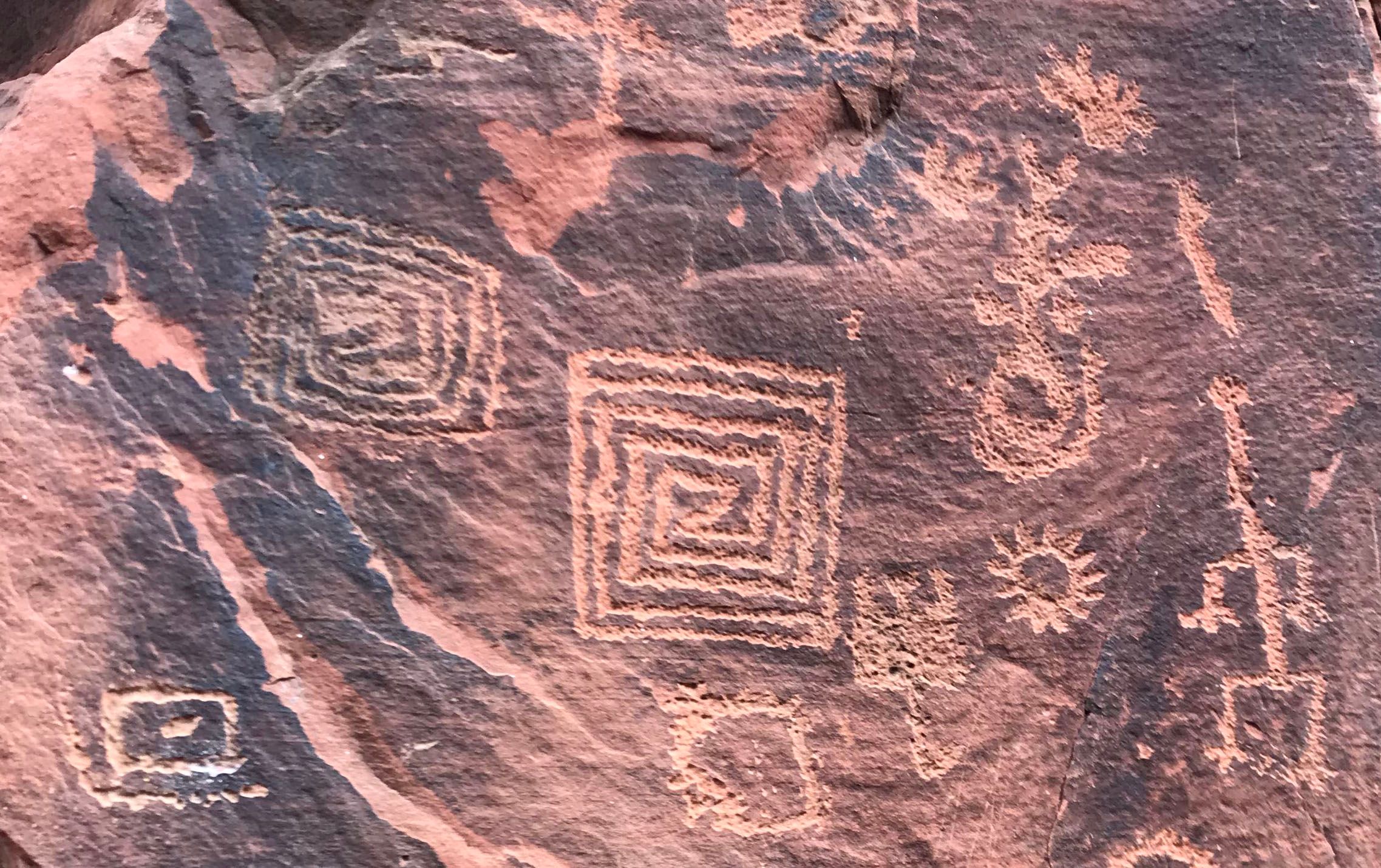
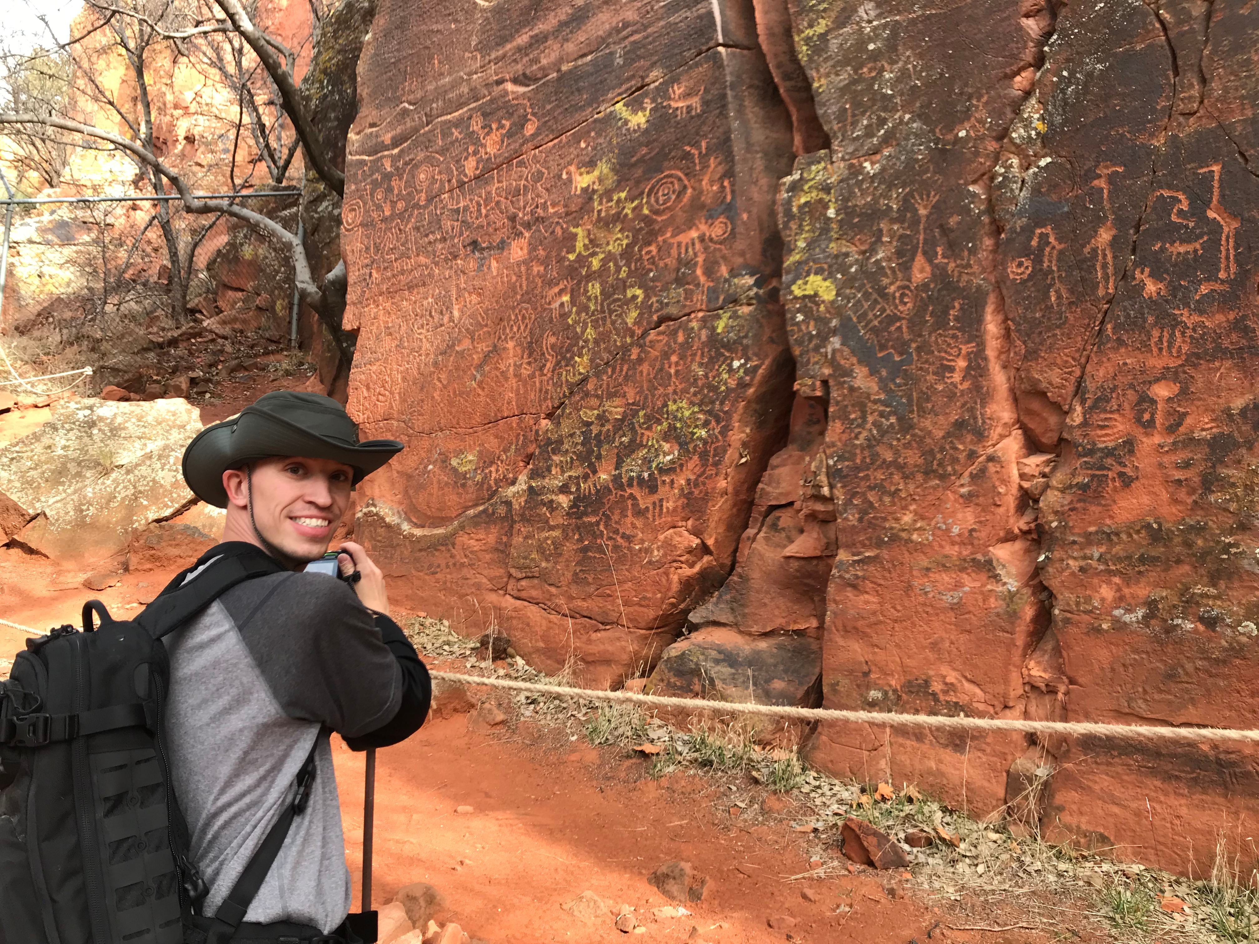
After an hour of climbing up, then down, this giant rock pedestal, we were off to see Ancient Indian Petroglyphs at the V-V Ranch nearby.
The symbols are left to interpretation, and can only guess what messages were intended. We can't be sure exactly their meanings since many generations have come and gone over the centuries.
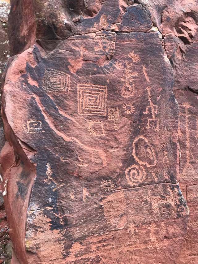
The petroglyphs were created by the Sinagua Indians between about 1150 and 1400. The Sinagua mysteriously disappeared from the area around 1400 and drifted in different directions. They had vanished by the time the first Europeans came to the area.
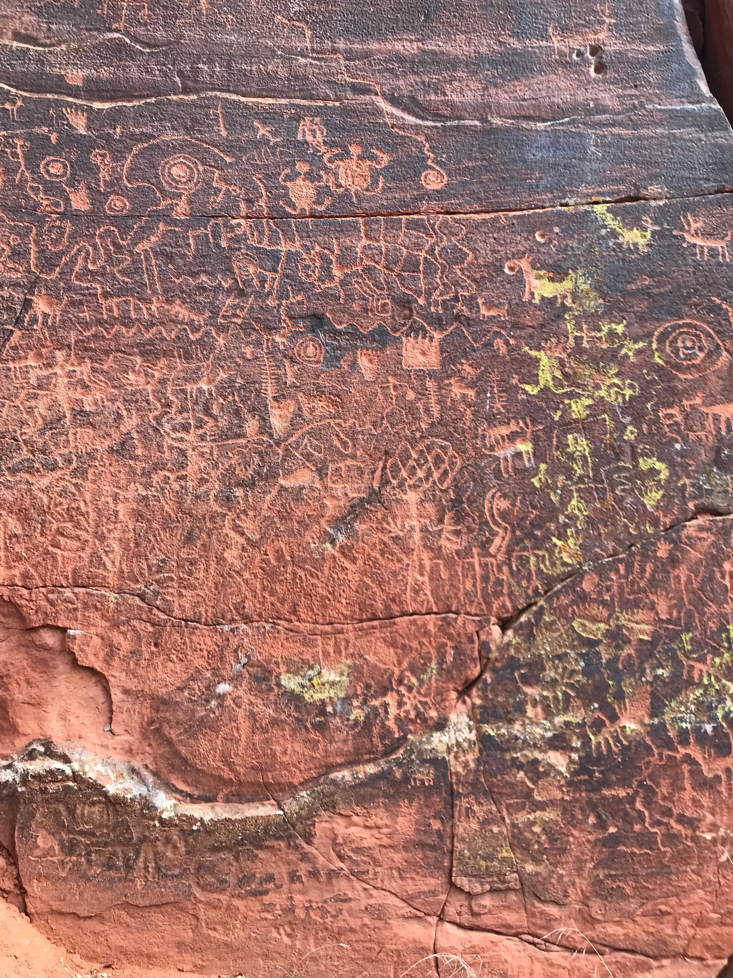
Having discovered ancient dwelling sites, the Spanish gave the name "Sinagua" to these ancient civilizations. The name means "without water".
Benjamin Franklin Taylor and his wife settled the area where the V-Bar-V is now located. Archeologists were made aware of the petroglyphs in about 1945. The Coconino National Forest acquired the site in 1994 and opened it to the public in 1996.

Archaeologists who explored the remote mesas of Northern Arizona have identified a previously undocumented group of petroglyphs, one of which confirms the presence of a prehistoric solar calendar.
The research had been led by experts affiliated with the Museum of Northern Arizona , with the support of the National Park Service. The supervisor of the study was David Purcell. Work began in 2014. The main goal of the project was to document the full extent of the rock art and other features of the site, many of which haven't been studied for decades or have never been seen before.
The result of their research is a complete library of photographic images of every panel, feature, and element of the area. The group of scientists were able to expand the scope of the project and conduct some pilot analysis as well. The works were focused on looking at how the rock art of the area is oriented to the horizon.The first information about petroglyphs in northern Arizona comes from the late 1800s. The study of them proved the human occupation of this area back as much as 4,000 years.
Among the petroglyphs, the most eye-catching is the one located on the southern face of a sandstone ledge at Horseshoe Mesa’s northern end.In 2006, archaeologists discovered another extraordinary petroglyph in Arizona. It was a rock carving which depicted an ancient star explosion seen by the Native Americans. It is believed to be the only known recording of a supernova in 1006 AD. That carving was found in the White Tanks Regional Park, Phoenix.
Thank you for sharing this topic.These issues are my specialty and I'm jealous of you.Because it must be so nice to be there. Thank you for reading @surfyogi
Great comment, very interesting to know, thanks!
According to Western Digs , the solar calendar has been marking the seasons for more than 700 years with a shadow dagger that travels across the sandstone face. This feature is made by a natural outcropping of rock above a panel of petroglyphs. Western Digs reports that the “shadow dagger” bisects a spiral carved onto the cliff wall, while another shadow interacts with a set of eight circles pecked into the panel’s left side.”
The researchers discovered the petroglyphs in the back country of the Wupatki National Monument site northeast of Flagstaff, in Arizona, USA. The area includes the ruins of dozens of sites built by Ancestral Puebloans, also known as the Kayenta or the Sinagua.
The Puebloans were an ancient Native American culture, who lived in southeastern Utah, northeastern Arizona, northwestern New Mexico, and southwestern Colorado. Researchers says that they developed as a part of the Oshara Tradition (circa 5,440 BC - 460 AD), which grew from the Paleo-Indian Picosa culture. Ancestral Puebloans lived in a range of structures from small family pit houses to larger buildings like grand pueblos - cliff side dwellings for defense and house clans. They especially dominated the Colorado Plateau and connected hundreds of communities around them.
Actually I was going to give more information, but I've kept my writing short for you to read.I wanted to write the rest.Thank you for reading @surfyogi
dude ive always wanted to go to that place, wow that's arizona? I thought new mexic, man I didntknow I lived so clos to such incredible ruins
and LOL
That guy obviously wanted people to think he might be Benjamin Franklin, like a name scammer lol
thank you:)
There are a couple of interesting theories. One of them, the one I find more fascinating, is that their entire tribe was lost in several battles with the Yavapai.
Sinagua means "without water" and Yavapai means "people of the sun".
Also, a couple of important tribes recognize the Sinagua as their ancestors. The Hopi tribe, for example.
This kind of historic episodes fascinates me.
I really like your comment!
I agree, I grew up near the Indian Reservation for Hopi Tribe near Mesa; Hopi are probably the lost Sinagua and it's very likely they gravitated to areas with more water near the Salt River near Mesa/PHX area, or even further into MX.
That's brilliant travel experience. You've to hiking world historical amazing place.The researchers watched the interplay of the sunlight at certain spots in different moments of the year. In the meantime, the documentation grew to 122 panels of petroglyphs at the Horseshoe Mesa and 107 at Middle Mesa. Altogether 138 new panels of petroglyphs were found, whilst others were rediscovered. But many of the panels contained dozens of individual petroglyphs. This sums up to the impressive number of more than 1,500 separate glyphs being recorded for the first time. The Puebloans were an ancient Native American culture, who lived in southeastern Utah, northeastern Arizona, northwestern New Mexico, and southwestern Colorado. Researchers says that they developed as a part of the Oshara Tradition (circa 5,440 BC - 460 AD), which grew from the Paleo-Indian Picosa culture. Ancestral Puebloans lived in a range of structures from small family pit houses to larger buildings like grand pueblos - cliff side dwellings for defense and house clans. They especially dominated the Colorado Plateau and connected hundreds of communities around them. Among the petroglyphs, the most eye-catching is the one located on the southern face of a sandstone ledge at Horseshoe Mesa’s northern end. It is known as Panel 50, and was recorded for the first time in 1931. Purcell confirmed that it is an imaging calendar, which means a time-tracking feature that uses the play of light and shadow. The panel is a set of eight circles, each 7 to 9 centimeters (3 to 4 inches) across, arranged in rows of two, three, two, and one. Nice you decides to share community.
STUNNING comment, thank you very much!
Wow, we really have quite a community here, were we can record these introspective views!
I want to hear MORE ABOUT SUN CALENDARS because all my friends now are saying, I MISSED THE BEST PART and they had a sun calendar and view points in the rocks like other ancient civilizations.
It only gets more amazing..
That is awesome !! I love hiking adventures . Where I lived upstate there were so many hiking paths and the best part was getting to the top and seeing the amazing view
This is the first time I am seeing you taking as a selfie. You seem to be very happy enjoying your trip.
It's a cool part of the country; we used to spend quite a lot of time around Sedona/Oak Creek and northern Arizona; my parents lived in Mesa when they were still alive and my mother-in-law in Prescott, so it was a great daytrip area. Did the obligatory Montezuma Castle visit but never got a chance to do any of the petroglyph trails; looks really cool.
I grew up in Mesa and went to school their, studied music at Mesa Community. Still one of the best music schools in US.
Oh, yes, a wonderful journey and great photos, these places in Arizona are impregnated with historical artifacts and the rock paintings of the Sinagua Indians are excellent evidence. Thank you @surfyogi for introducing us to these interesting places!
thats great to see you on your beautifull journey and also hiking is my best that its give us many enjoyment which we cannot find in other things and travels
hope you enjoyed in oak creek canyon and nice to hear about that you see the Dr. Rob and his son showed you old cave dwellings built into the side of the mountain and really best photos your shared with us and all your followers specailly this 3rd photo and selfie is exellent showing the best natural beauty around every side @surfyogi ,, i am seeing your first journey after my follow your blog and really feel glad that your journey is best and you have an adveture of life in your travel hope we see more best photos from your travel like like this
i dont know about Dr.Rob maybe i missed your post when you tell about him
Nice those belong on the blockchain. Too many times I have seen people vandalize the sweet petroglyphs we have. I live in the area kind of, the same sort of landscapes.. We need more good documentation of all the things that people will destroy in the future. Like the boyscout leader at goblin valley, or the crazy islamists did to the sweet Buddhist statues in their country.
Oh!. Very beautiful I'm fall in love with these Image.I can't describe beauty by words because it's one type of feeling which every single people have. This picture is better than better. Perfect Click without any doubt.
Capturing nature in all its glory of own creativity. Travel photography is a genre of photography that may involve the documentation of an area's landscape, people, cultures, customs and history. You have a great theoretical knowledge and experience about to make good photography as well as creative perspectives. Your creative perspectives really impressed me. Because without creative perspectives it is not possible to capture this types of glamorous photography.