Part 7 of 8 - My Epic Simpson Desert (Munga Thirri) Crossing - BIG RED | 3 States, 3 Time Zones - All in one place
Total days – 13
Route – Adelaide | Coober Pedy | Arckaringa | Oodnadatta | Dalhousie | Mt Dare | Simpson Desert | Birdsville | Adelaide.
Total Distance – 3180km (1975mi)
If you missed the first four parts of this eight-part series, please use the links at the bottom of this post to read all the posts from this amazing trip through Outback Australia.
INTO THE SIMPSON (Munga Thirri)
POEPPEL CORNER - Three States | Three Time Zones
The Simpson desert spans over the three states, namely, South Australia(SA), Northern Territories(NT) and Queensland(QLD). The French Track ended at the eastern end of the South Australian part of the desert. Thereafter we turned onto the QAA line which starts a little into Queensland. This took us over the Big Red and into the town of Birdsville.
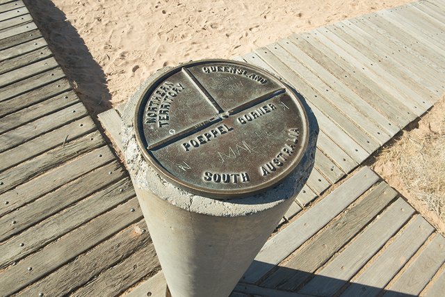
Before getting onto the QAA line we spent a short time at the unique location of "Poeppel Corner", where all three states meet, three different time zones.
Poeppel's corner is a must stop point for anyone traveling through the Simpson Desert. It is quite unique as the states of Northern Territories, Queensland and South Australia all meet at this point. Not only is the meeting of the three states unique, but also, it is the intersection of three time zones. Spend some time at this location and you will have the experience of seeing midday and midnight occur three times.
This meeting point is named after Augustus Poeppel, a surveyor, who conducted a survey in the mid 1880s to find the exact location where the three states met.
The original post Poeppel erected was wooden, carved to a triangular shape with each state name engraved on the respective sides. This post is still standing and all overlanders crossing the Simpson Desert make the pilgrimage each year. It is estimated that around 2,000 visitors travel to Poeppel corner annually.
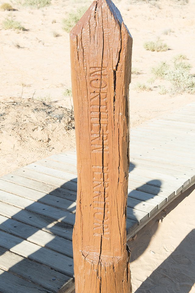
Erected in the mid 1880s, the post was only seen by indigenous Australians until 1936 when the first European settler to cross the Simpson came across the post.
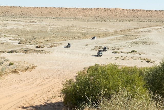
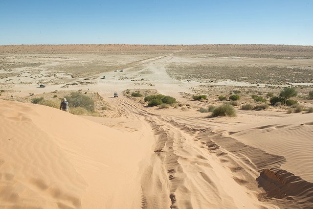
BIG RED - The Mother of all dunes
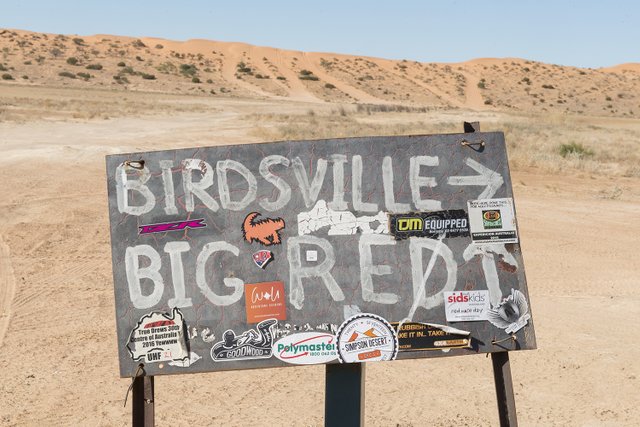
At a towering height of 30 meters (100 feet) “The Big Red” sand dune, last of the 1100 parallel dunes making up the Simpson, signified the end of the Simpson crossing for us. As per tradition, the journey is not complete (for 4x4 enthusiast) without climbing to the top of the mother of all dunes. So keeping to tradition, several attempts later, all three heavily laden fourbies were parked on the top whilst we celebrated the epic crossing.
Lining Up To Make The Run Up Big Red
Making The Run
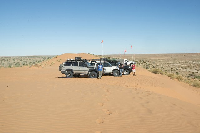
On Top Of Big Red
BIRDSVILLE - A Place To Reflect On The Journey Completed
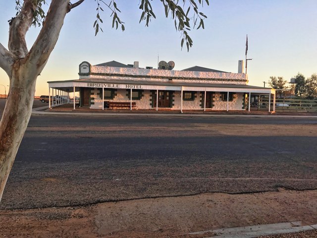
The sparsely populated (approximately 100 people) town of Birdsville was a welcome site for us after having spent the prior several days in the bush. This iconic town located at the bottom edge of QLD (bordering SA) was first established back in the late 1800s to collect toll from the drovers of cattle being moved interstate.
The iconic Birdsville Hotel/Pub is as old as the town itself offering hearty meals and comfortable accommodation to travellers as it had done over a 100 years ago. After checking into our rooms and a much needed hot shower, I made my way to the pub to get a drink and to try and meet some of the locals. I was in for a treat, spending the better part of the evening getting to know one of Birdsville’s well-known locals (and his dog).
Tourism plays a big role in the sustainment of this town. As with any outback pub, Birdsville hotel was full of outback travellers. Some, like us, had just completed the Simpson crossing (West to East) and others were about to start their crossing.
Outback pub meals always taste divine when taken in the context of one’s journey, the environment and the friends keeping you company. My Birdsville dinner of traditional veggies and meat certainly was divine and quite filling. Afterwards, it was back to the pub and a few games of pool with the other travellers before calling it a night.
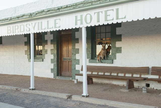
A Dog On A Windowsill Greets Us.
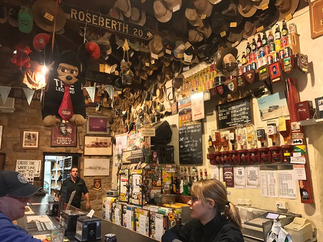
Every Inch Of Space Taken Up By Memorabilia
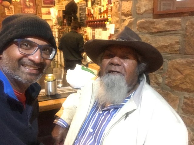
Meeting A Local Legend
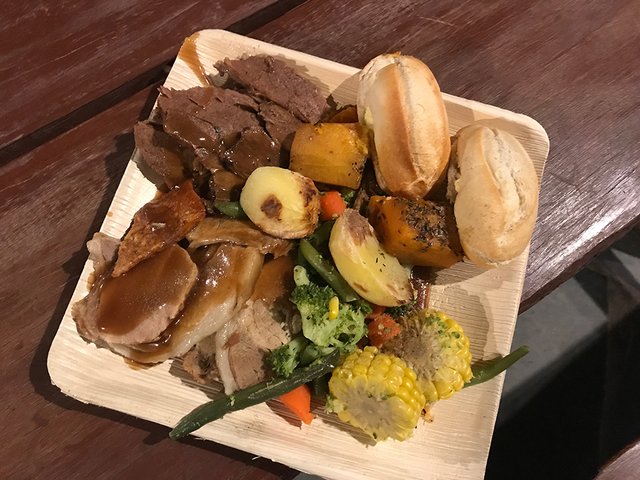
Nothing Quite Like A Filling Pub Meal
Part 8 to be posted soon - The Long Ride Back Home | A Souvenir Unique
Follow me on this epic overlanding trip.
Live life to the fullest, it's too short to procrastinate!
Duncan Udawatta
#tinyplanet #teamaustralia #overlanding
PART 1 - An Underground City | SiFi Movie sets | Dynamite From The Local Supermarket.
https://steemit.com/travel/@overlandjournals/my-epic-simpson-desert-munga-thirri-crossing-part-1-of-8-an-underground-city-dynamite-from-the-local-supermarket-sifi-movie-sets
PART 2 - The Breakaways | Longest Dog Fence In The World.
https://steemit.com/travel/@overlandjournals/part-2-of-8-my-epic-simpson-desert-munga-thirri-crossing-longest-dog-fence-in-the-world-or-kanku-breakaways-conservation-park
PART 3 - A 80 Million Year Old Painted Desert.
https://steemit.com/travel/@overlandjournals/part-3-of-8-my-epic-simpson-desert-munga-thirri-crossing-an-80-million-year-old-painted-desert
PART 4 - Hot Water On Tap In The Middle Of The Outback.
https://steemit.com/travel/@overlandjournals/part-4-of-8-my-epic-simpson-desert-munga-thirri-crossing-dalhousie-springs-or-hot-water-on-tap-in-the-middle-of-the-outback
PART 5 - Car Trouble in the middle of nowhere with night approaching!
https://steemit.com/travel/@overlandjournals/part-5-of-8-my-epic-simpson-desert-munga-thirri-crossing-mt-dare-hotel-or-car-trouble-in-the-middle-of-no-where-with-night
Part 6 - My Epic Simpson Desert (Munga Thirri) Crossing - Into The Simpson | Big Sky Country
https://steemit.com/travel/@overlandjournals/part-6-of-8-my-epic-simpson-desert-munga-thirri-crossing-into-the-simpson-or-big-sky-country
Congratulations, Your Post Has Been Added To The Steemit Worldmap!
Author link: http://steemitworldmap.com?author=overlandjournals
Post link: http://steemitworldmap.com?post=part-7-of-8-my-epic-simpson-desert-munga-thirri-crossing-big-red-or-3-states-3-time-zones-all-in-one-place
Want to have your post on the map too?
Congratulations! This post has been upvoted from the communal account, @minnowsupport, by OverlandJournals from the Minnow Support Project. It's a witness project run by aggroed, ausbitbank, teamsteem, theprophet0, someguy123, neoxian, followbtcnews, and netuoso. The goal is to help Steemit grow by supporting Minnows. Please find us at the Peace, Abundance, and Liberty Network (PALnet) Discord Channel. It's a completely public and open space to all members of the Steemit community who voluntarily choose to be there.
If you would like to delegate to the Minnow Support Project you can do so by clicking on the following links: 50SP, 100SP, 250SP, 500SP, 1000SP, 5000SP.
Be sure to leave at least 50SP undelegated on your account.
Congratulations, Your Post Has Been Added To The Steemit Worldmap!
Author link: http://steemitworldmap.com?author=overlandjournals
Post link: http://steemitworldmap.com?post=part-7-of-8-my-epic-simpson-desert-munga-thirri-crossing-big-red-or-3-states-3-time-zones-all-in-one-place
Want to have your post on the map too?
The thingy at the border is cool. I never knew about that, even though it makes sense there'd be something.
It was part of the surveying work assigned to Peoppel. From what I understood, at the time the authorities didn't quite know where the respective state borders were. Peoppel had dragged the measuring chains along the ground so once he got to the site he got his measurement wrong as the chain had stretched over the distance. The modern-day marker is in the right place. About 3 meters from where the original was planted. :)
The dedication and the trouble they went to those days has to be admired for sure.
Lol. That reminds me of where the equator is in Quito, Ecuador. The old temple thingy is about 3m away from where it's supposed to be, but the new markers are obviously right.
at least they tried :D
That's a pretty decent pub meal O_O That post is pretty cool, and I like that someone bothered to go all the way out there just to find the spot where three imaginary lines intersect XD That's some dedication.
It was part of the surveying work assigned to Peoppel. From what I understood, at the time the authorities didn't quite know where the respective state borders were. Peoppel had dragged the measuring chains along the ground so once he got to the site he got his measurement wrong as the chain had stretched over the distance. The modern-day marker is in the right place. About 3 meters from where the original was planted. :)
The dedication and the trouble they went to those days has to be admired for sure.
LOVE outback pub meals!!!